Exploring The Los Padres National Forest
1,257 Miles of Trails on 1,762,400 Acres, with 875,000 Acres of Protected Wilderness to Explore.
Thank you for taking the time to visit the Hike Los Padres Community. This website was created with the mission of being a source of shared information on trails, camps, and locations across the entire Northern and Southern portions of the Los Padres National Forest. The more information we all share and catalog, the better we can track the conditions of the forest network and figure out what sections, trails, and locations are safe to use and which need maintenance.
A good portion of the interior of Los Padres National Forest gets very little use by the public, so any information on these areas will ensure that these places remain accessible for future generations of hikers, backpackers, trail runners, equestrians, O.H.V, hunters, cyclists, and explorers. Many of the trails listed may be unmaintained. Know your level of ability, and always remember to bring extra water.
In partnership with the Los Padres Forest Association (LPFA). The LPFA’s mission is to care for the Los Padres Forest, ensuring it thrives and remains safe and open for the people to use and enjoy. LPFA volunteers work to keep trails open, report and assess forest conditions and provide public education on how to use the forest safely. If you are interested in becoming a member or volunteering, please visit www.lpforest.org to learn more.
Over 1000+ Cataloged Locations
Location specific weather reports, recent camp and trail surveys, water data and much more.
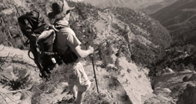
Explore the hiking trails of the Los Padres National Forest. Combine trails to make loop trips, discover new trails for backpacking, or find new areas to explore.
205 Hiking Trails
View All 205 Trails →
This updated list on camps enables you to find a new camp to visit anytime; we have included all car campgrounds and trail camps in this section.
293 Camps
View All 293 Camps →
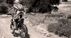
We got you covered on the O.H.V areas, including Google maps view of all trails, slope gains and losses, so you can be prepared for your next off road adventure.
56 OHV Trails
View All O.H.V. Trails →
Recent Water Reports
View All Water Reports
Latest Camp Reports
Please click on a report below to view the survey
 Middle Matilija Camp Survey - 08-01-2026 - by Max Stern
| Link: | Middle Matilija Camp |
| Date: | 08-01-2026 |
| Surveyor Name: | Max Stern |
| Camp Description: | Middle Matilija Camp is in good shape. There are two sites separated by a fair distance and equipped with primitive fire pits. The lower site has a larger fire pit but limited tent space. The upper site has plenty of space. The trail leading into the area is mostly in good condition. |
| Water Source: | Flowing |
| Water Source Details: | |
| Weather Conditions: | Sunny, ~85F mid-morning |
- Matilija Camp Survey - 08-01-2026 - by Max Stern
| Link: | Matilija Camp |
| Date: | 08-01-2026 |
| Surveyor Name: | Max Stern |
| Camp Description: | Matilija Camp is in good condition. I noticed two sites, referenced in other posts on this website as site #2 and site #3. Sites #1 and #4 were too difficult to find if they even still exist. Site #2 is a very large space with an abundance of shade and flat ground with a decently-sized primitive fire pit. It also provides excellent access to a great swimming spot in the creek. Site #3 (the official Forest Service site) is adequate, but quite rocky surrounding the rather small fire pit, though this fire pit includes a grill on top. The trail is in excellent condition in this area. |
| Water Source: | Flowing |
| Water Source Details: | |
| Weather Conditions: | Sunny, ~90F late-morning |
- Upper Santa Ynez Camp Survey - 07-30-2026 - by Anonymous Surveyor
| Link: | Upper Santa Ynez Camp |
| Date: | 07-30-2026 |
| Surveyor Name: | Anonymous Surveyor |
| Camp Description: | |
| Water Source: | Flowing |
| Water Source Details: | Massive flow. Pool deep enough to swim |
| Weather Conditions: | Clear Sunny Very hot |
- Valley View Camp Survey - 07-12-2026 - by Anonymous Surveyor
| Link: | Valley View Camp |
| Date: | 07-12-2026 |
| Surveyor Name: | Anonymous Surveyor |
| Camp Description: | |
| Water Source: | Flowing |
| Water Source Details: | |
| Weather Conditions: | |
- Raspberry Camp Survey - 07-12-2026 - by Dylan
| Link: | Raspberry Camp |
| Date: | 07-12-2026 |
| Surveyor Name: | Dylan |
| Camp Description: | |
| Water Source: | Flowing |
| Water Source Details: | Light, steady flow. |
| Weather Conditions: | |
- Chorro Grande Camp Survey - 07-11-2026 - by Dylan
| Link: | Chorro Grande Camp |
| Date: | 07-11-2026 |
| Surveyor Name: | Dylan |
| Camp Description: | |
| Water Source: | Flowing |
| Water Source Details: | Good, steady flow |
| Weather Conditions: | |
- Raspberry Camp Survey - 07-07-2026 - by Max Stern
| Link: | Raspberry Camp |
| Date: | 07-07-2026 |
| Surveyor Name: | Max Stern |
| Camp Description: | Raspberry Camp is in good shape. It is accessible by a half-mile trail (also in good shape) that comes down from site 1 of Reyes Peak Campground. There’s plenty of shade under the pines and plenty of room to set up camp, though the ground isn’t perfectly flat. Firewood can be easily found in the surrounding area. There is a spring that can be accessed by following a short path further down from the camp for just a couple of minutes. You’ll know you’ve found it when you see patches of bright green grass. There are two steel pipes that provide water. The closest one to the camp is in great shape and was flowing steadily enough to fill large bottles with cold water in a few minutes, but the second pipe has a leak right where it emerges from the ground. As of early July, there are no ripe raspberries in the area. |
| Water Source: | Flowing |
| Water Source Details: | Weak flow but stronger than a trickle |
| Weather Conditions: | Sunny, ~75F late morning |
- Murietta Camp Survey - 07-06-2026 - by Max Stern
| Link: | Murietta Camp |
| Date: | 07-06-2026 |
| Surveyor Name: | Max Stern |
| Camp Description: | Murietta Camp could use some maintenance. One of the secondary sites is overgrown and the other is partially overgrown. From what I understand, there's supposed to be a larger main site, but I didn't see that one, probably because I didn't look hard enough. The camp provides excellent access to the river, with several pools to go for a dip in as of early July.
Murietta Trail leading up to this camp is overgrown and somewhat difficult to follow, though it doesn't take long to get there from the trailhead. Murietta Trail heading out of this camp is entirely overgrown and extremely difficult to identify, let alone follow. Don't attempt the upper section of this trail that "connects" to Murietta Divide Road unless you really want to be constantly torn up by foliage whilst wondering if you're even on a trail. But... it can be done. Ask me how I know. |
| Water Source: | Flowing |
| Water Source Details: | |
| Weather Conditions: | Sunny, ~70F mid-morning in July |
- Three Mile Camp Survey - 06-28-2026 - by Kevin H
| Link: | Three Mile Camp |
| Date: | 06-28-2026 |
| Surveyor Name: | Kevin H |
| Camp Description: | We also tightened up the bolts on the picnic table and now it's solid. |
| Water Source: | Flowing |
| Water Source Details: | decent flow still; a little more than a trickle. |
| Weather Conditions: | dropped to 41 degrees at night |
- Chorro Grande Camp Survey - 06-27-2026 - by Jake Eastwood
| Link: | Chorro Grande Camp |
| Date: | 06-27-2026 |
| Surveyor Name: | Jake Eastwood |
| Camp Description: | Water is moving and fresh, but filtration is required. |
| Water Source: | Flowing |
| Water Source Details: | Flow is able to fill a Nalgene bottle (32 oz) in 3-4 seconds |
| Weather Conditions: | |
View All Camp Reports
Latest Trail Reports
Please click on a report below to view the survey
- Wheeler Gorge Nature Trail Survey - 07-13-2026 - by Los Padres Forest Association
| Link: | Wheeler Gorge Nature Trail |
| Date: | 07-13-2026 |
| Surveyor Name: | Los Padres Forest Association |
| Trail description: | LPFA has brushed and restored tread on most of this nice little loop trail. It's in great shape, enjoy! |
| Mode of transport: | Hike |
| Trail condition: | Good shape and easy to follow |
- Little Mutau Trail Survey - 06-13-2026 - by Anonymous Surveyor
| Link: | Little Mutau Trail |
| Date: | 06-13-2026 |
| Surveyor Name: | Anonymous Surveyor |
| Trail description: | Trail was evident but loose and bushes encroaching. Only made it . 5 miles in with my dog before calling it as the thought of 3+ more miles of that condition seemed impossible if it was so bad that early on. |
| Mode of transport: | Hike |
| Trail condition: | Needs some work |
- Piedra Blanca Trail Survey - 06-08-2026 - by Los Padres Forest Association
| Link: | Piedra Blanca Trail |
| Date: | 06-08-2026 |
| Surveyor Name: | Los Padres Forest Association |
| Trail description: | LPFA completed a 10-day Volunteer Working Vacation to work the trail from Pine Mountain Lodge Camp toward Haddock Camp. We completed 3.3 miles of work, including brushing, restoring sketchy tread and the slide between 3 Mile and Haddock Camps, defining the route through creek crossings, and cutting out 13 downed logs blocking the trail. It is still brushy with a few downed trees the remaining .7 miles to Haddock Camp, but easy to follow. Looking good out there! |
| Mode of transport: | Hike |
| Trail condition: | Needs some work |
- Red Reef Trail Survey - 06-06-2026 - by Andrew
| Link: | Red Reef Trail |
| Date: | 06-06-2026 |
| Surveyor Name: | Andrew |
| Trail description: | Red Reef trail from Topa Topa to Sespe River. The tread is in good shape except for 2-3 wash-outs, so the trail is easy to follow. However, it frequently requires pushing through thick foliage. A good brushing would go a long way. Found Ladybug Camp by following a side trail that looks more like a washout, campsite is in great shape with several clear tent sites and running water. |
| Mode of transport: | Hike |
| Trail condition: | Needs some work |
- Potrero John Trail Survey - 06-01-2026 - by Los Padres Forest Association
| Link: | Potrero John Trail |
| Date: | 06-01-2026 |
| Surveyor Name: | Los Padres Forest Association |
| Trail description: | LPFA spent several days this spring brushing the trail from the trailhead to Potrero John Camp. The trail is in great shape! |
| Mode of transport: | Hike |
| Trail condition: | Good shape and easy to follow |
- San Ysidro Trail Survey - 05-29-2026 - by Los Padres Forest Association
| Link: | San Ysidro Trail |
| Date: | 05-29-2026 |
| Surveyor Name: | Los Padres Forest Association |
| Trail description: | MTF and the LPFA Trail Crew brushed the upper section of the trail. It's in great shape! |
| Mode of transport: | Hike |
| Trail condition: | Good shape and easy to follow |
- Agua Blanca Trail Survey - 05-28-2026 - by Holden A. Branch
| Link: | Agua Blanca Trail |
| Date: | 05-28-2026 |
| Surveyor Name: | Holden A. Branch |
| Trail description: | "Camp Agua Blanca" (end of road, start of trail) to Log Cabin is in good condition, it's a beautiful walk. However, you really gotta look at the map all the time because the trail goes up on the ridges of the river bank. it's marked, however it's easy to get off if you're rockhopping, and when you go astray it's not fun. Pothole trailhead up the road is not a fun walk. Be prepared to take shoes off for that section. |
| Mode of transport: | Hike |
| Trail condition: | Good shape and easy to follow |
- Sespe River Trail Survey - 05-27-2026 - by Daniel J. Hall
| Link: | Sespe River Trail |
| Date: | 05-27-2026 |
| Surveyor Name: | Daniel J. Hall |
| Trail description: | Nothing new and worthwhile to add beyond the preceding two surveys, except that the Forest Service recently installed a vending machine at the Piedra Blanca Trailhead from which you can purchase an Adventure Pass. No cash accepted; only credit cards.
Photo hopefully above, or at https://tinyurl.com/227vctt5 |
| Mode of transport: | Hike |
| Trail condition: | Good shape and easy to follow |
- Pine Mountain Trail Survey - 05-22-2026 - by Anonymous Surveyor
| Link: | Pine Mountain Trail |
| Date: | 05-22-2026 |
| Surveyor Name: | Anonymous Surveyor |
| Trail description: | I began from 29S18 (labelled on some maps as an extension of Pine Mountain Rd and some maps as Queen Bee Rd). I drove up 29S18 from Pozo Rd in a 2wd vehicle easily, and probably could have continued driving up the first couple miles of Pine Mtn Trail to Castle Crags Trail. I split off at Castle Crags Trail, but ran into 2 dirt bikers heading up the other way toward Las Chiches. No water on the route, expect temperatures to be similar or higher than the forecast in Pozo. There is a register for the trail at (35.32599, -120.23948) that is sorely in need of a new notebook. If you're into geology, you'll love the views from this trail - it looks like Pinnacles NP from afar but up close you can see all the details in the sedimentary conglomerates and the wind erosion has created some interesting layering effects. See my review for Castle Crags Trail as well.
|
| Mode of transport: | Array |
| Trail condition: | Good shape and easy to follow |
- Castle Crags Trail Survey - 05-22-2026 - by Anonymous Surveyor
| Link: | Castle Crags Trail |
| Date: | 05-22-2026 |
| Surveyor Name: | Anonymous Surveyor |
| Trail description: | I began from 29S18 (labelled on some maps as an extension of Pine Mountain Rd and some maps as Queen Bee Rd). I drove up 29S18 from Pozo Rd in a 2wd vehicle easily, and probably could have continued driving up the first couple miles of Pine Mtn Trail to Castle Crags Trail. I split off at Castle Crags Trail, there is a register nearby at (35.32599, -120.23948) that is sorely in need of a new notebook. No water on the route, expect temperatures to be similar or higher than the forecast in Pozo. I followed the trail out to (35.30220, -120.22200) and then tried bushwhacking down to the castle crags formation. I only made it about a half mile before cutting my losses, climbing a tree, and enjoying the view. No ticks, no poison oak, but the flies are evil and will bite you through your clothing. |
| Mode of transport: | Hike |
| Trail condition: | Needs some work |
| Condition details: | Easy to follow for the most part, but nonexistent to hike out to the Castle Crags formation itself |
View All Trail Reports
 Use Marker Groups
 Tower OHV Trail
  Potrero John Trail
  Indian Valley Camp
  Arroyo Seco Dua - Forest…
  Garcia Mountain
  Hot Spring - Cachuma…