 Use Marker Groups
 Wolf 2002
Piru 2003
Day 2006
Zaca 2007
Gap 2008
La Brea 2009

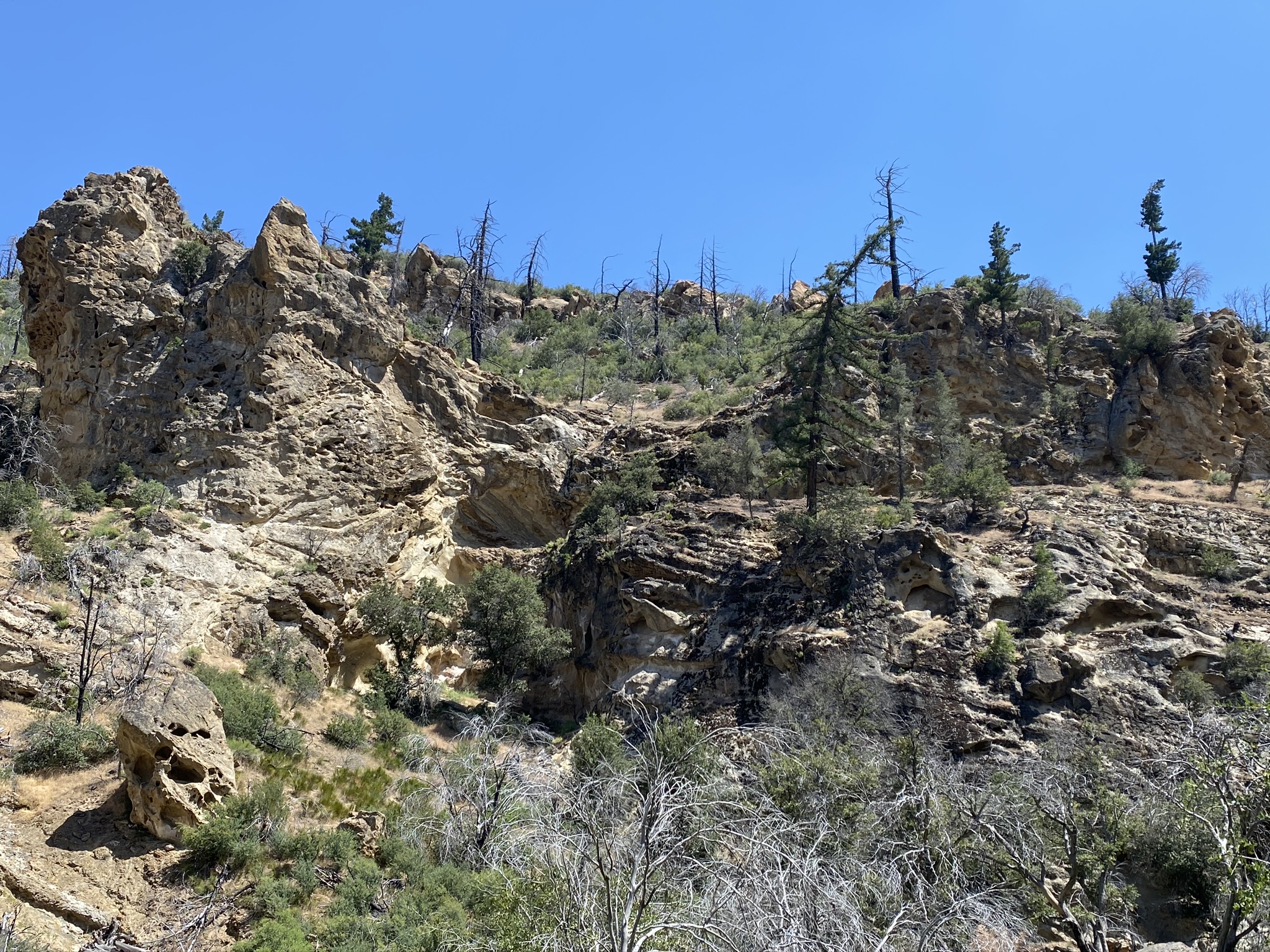
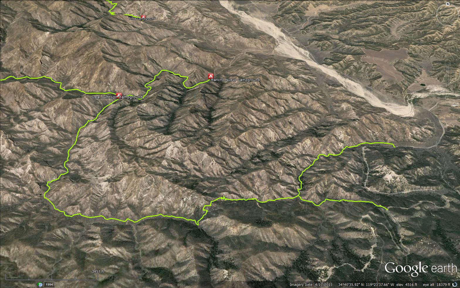
The Deal Trail is a 6 mile trail that is partially in the Dick Smith Wilderness, in Ventura County. The trail begins from Highway 33 and the completes at the Rancho Nuevo Trail (24W03).


 Deal Trail Survey - 02-08-2026 - by Tom Chard
| Link: | Deal Trail |
| Date: | 02-08-2026 |
| Surveyor Name: | Tom Chard |
| Trail description: | From Deal Trailhead made it 1.3 miles before too many down trees. Canyon was narrowing and did not know how many more trees to go soooo retreated and went up to Deal Connector TH to Deal Trail. First 2.1 to 2.2 miles trail is in good shape. Past that (into the canyon past the wilderness sign on the ridge) you are where the last trail crew stopped. Very brushed, hard to constantly push through and was getting hard to follow. |
| Mode of transport: | Hike |
| Trail condition: | Hard to follow |
| Condition details: | Brushed over 2.1 miles from Deal Connector TH |
Deal Trail Survey - 02-13-2022 - by Los Padres Forest Association| Link: | Deal Trail |
| Date: | 02-13-2022 |
| Surveyor Name: | Los Padres Forest Association |
| Trail description: | The MPRD hosted another project on the Deal Trail as part of their annual Super Bowl Sunday project. This year the volunteers worked from the eastern Deal TH up the Bear Canyon portion and out to the wilderness boundary focused on brushing, tree clearing and some light tread. LOOKS GOOD! |
| Mode of transport: | Array |
| Trail condition: | Needs some work |
Deal Trail Survey - 03-14-2022 - by Daniel J. Hall| Link: | Deal Trail |
| Date: | 03-14-2022 |
| Surveyor Name: | Daniel J. Hall |
| Trail description: | We started from the Deal Connector Trailhead (not the Deal Trailhead farther north on Route 33), went past the Mine Camp Spur Trail and connected with the Deal Trail at the marked junction after .9 miles. We then took the Deal Trail up and past the Dick Smith Wilderness Boundary, down the other side and on to about a quarter mile past where the trail intersects with Deal Canyon coming in from the left/south. There was no water in the creek and so we went no further. To that point, the trail was in good shape and easy to follow. However, there were minor slides in the switchbacks before the wilderness boundary and some brushy sections in the last half mile we hiked. The Mine Camp Spur Trail was very brushy, there were blowdowns across it and it was sometimes hard to find. Mine Camp was in good shape, but had no drinkable water. More detail in captioned photos at https://tinyurl.com/bdhn6da2 |
| Mode of transport: | Hike |
| Trail condition: | Good shape and easy to follow |
Deal Trail Survey - 06-27-2020 - by Antonio Calderon| Link: | Deal Trail |
| Date: | 06-27-2020 |
| Surveyor Name: | Antonio Calderon |
| Trail description: | Still plenty of water flow. Some brushy areas but easy to follow. Found lots and lots of ticks. |
| Mode of transport: | Hike |
| Trail condition: | Needs some work |
| Images: | |
Deal Trail Survey - 05-21-2020 - by Nate M| Link: | Deal Trail |
| Date: | 05-21-2020 |
| Surveyor Name: | Nate M |
| Trail description: | I started this trail from the bottom at the Rancho Nuevo camp. The trail is pretty overgrown in many places but still followable. I put my machete to good use but there are a lot of overhangs that have grown this Spring. Creek is flowing well the whole way. Put some videos up on IG as @picbynathan |
| Mode of transport: | Hike |
| Trail condition: | Needs some work |
| Condition details: | Needs work |
| Images: | |
Deal Trail Survey - 04-05-2020 - by Louis Tremblay| Link: | Deal Trail |
| Date: | 04-05-2020 |
| Surveyor Name: | Louis Tremblay |
| Trail description: | Wow this trail is a MUST for people! Those rock features in the canyons are amazing. Trail condition: the previous trail work has held up well. Easy enough to follow, only lost the trail twice. Very minor bushwhacking at times with 2 fallen trees that are easy to get around. A few loppers at places would help but otherwise we had a great time! |
| Mode of transport: | Hike |
| Trail condition: | Good shape and easy to follow |
Deal Trail Survey - 01-07-2020 - by Valerie Norton| Link: | Deal Trail |
| Date: | 01-07-2020 |
| Surveyor Name: | Valerie Norton |
| Trail description: | I hiked a loop along the Deal Trail and Rancho Nuevo. I started down the spur, but decided not to face its blow downs twice. There were some high winds up here and my arms got very tired from throwing small trees off the trail. I'd say half my hikes along this trail were in the context of trail work, so I was in a trail work frame of mind. Also, there would have normally been a bit of work about to happen on this one, but the yearly work moved over to the nearby NRT. They get all the attention. There's still a few bigger trees on the trail. Nothing much more than a foot in diameter to my memory. The only thing difficult to cross that didn't get tossed off the trail was up in the section that is usually skipped by using the connector instead. (That's outside the wilderness.) There is some difficulty navigating in the upper sections within the wilderness. I might have even felt slightly lost at one point, but everything follows the creek, so there is an overriding navigation to follow. |
| Mode of transport: | Hike |
| Trail condition: | Good shape and easy to follow |
Deal Trail Survey - 08-23-2019 - by Los Padres Forest Association| Link: | Deal Trail |
| Date: | 08-23-2019 |
| Surveyor Name: | Los Padres Forest Association |
| Trail description: | As part of a NFWF trail grant, the LPFA restored 4.7 miles of the Deal Trail during the 2018-2019 trail season. We worked the trail from the Deal Connector junction out to Deal Junction Camp. The trail should be in excellent shape for the 2019-2020 hiking season! Go check out this beautiful, wild, yet not that remote trail which also happens to be part of the Condor Trail. Year round water was found at this location: 34°
39' 57.12" N, 119° 24' 58.8" W
|
| Mode of transport: | Hike |
| Trail condition: | Good shape and easy to follow |
| Images: | A before and after along the middle part of the Deal Trail, below the Narrows Another before and after along the middle part of the Deal Trail, below the Narrows The trail heading up from Deal Junction Camp, wide open. The LPFA Trail Crew, braving the cold, snow and sleet in February 2019. |
Deal Trail Survey - 05-08-2019 - by Diane Soini| Link: | Deal Trail |
| Date: | 05-08-2019 |
| Surveyor Name: | Diane Soini |
| Trail description: | Other than a short stretch in the middle, the trail was in good shape. Someone has put up tape along the short stretch in the middle to guide you through. There was no trail in this section and you just had to push through the brush. Other than that, the trail was in good shape and the cliffs and the creek were gorgeous. This trail is a hidden gem. |
| Mode of transport: | Hike |
| Trail condition: | Good shape and easy to follow |
Deal Trail Survey - 12-01-2018 - by MSubbotin| Link: | Deal Trail |
| Date: | 12-01-2018 |
| Surveyor Name: | MSubbotin |
| Trail description: | MPRD Volunteer Trail project with Order of the Arrow BSA re-established the first 1/4 mile of trail from the trailhead by brushing and removing slough to FS standard. Â Trail report of 5/16 had indicated trail was impossible to follow, but not longer! |
| Mode of transport: | Hike |
| Trail condition: | Good shape and easy to follow |
| Images: | Order of the Arrow w/ Chapter Chief Jack and support team. |
Deal Trail Survey - 11-20-2018 - by Los Padres Forest Association| Link: | Deal Trail |
| Date: | 11-20-2018 |
| Surveyor Name: | Los Padres Forest Association |
| Trail description: | LPFA survey of the Deal Trail from the Deal Connector (Hwy 33) into the wilderness and down past the Narrows. See detailed trail report slideshow below. The trail is followable now thanks to a fresh set of pink flagging but expect to have to push through brush and wander a little looking for the path of least resistance. There are 8 downed trees along the trail but none of them should cause any problems to get around. Water was found in one spot between the wilderness boundary and the Narrows. Very pretty canyon and quite wild. Did not see any bear signs. This is along the Condor Trail. LPFA and MPRD will be working this trail later in 2018-2019 trail season. https://arcg.is/05LGOG |
| Mode of transport: | Hike |
| Trail condition: | Needs some work |
| Images: | The water was located in this thicket of willows. Note pink flags designating the trail. View down towards the narrows, very picturesque. The mammoth downed oak in the narrows will need a skilled sawyer to clear. View from Deal Trail down across Hwy 33 and towards Pine Mountain. |
Deal Trail Survey - 05-21-2018 - by Los Padres Forest Association| Link: | Deal Trail |
| Date: | 05-21-2018 |
| Surveyor Name: | Los Padres Forest Association |
| Trail description: | Condor Trail hikers reported the section of trail from Deal Junction to the wilderness boundary was in "need of some serious work". Water was available at all the nearby camps and along most of the usual sections of the trail. No water at Upper Tinta or Tinta Camps. |
| Mode of transport: | Hike |
| Trail condition: | Needs some work |
Deal Trail Survey - 01-07-2018 - by MSubbotin| Link: | Deal Trail |
| Date: | 01-07-2018 |
| Surveyor Name: | MSubbotin |
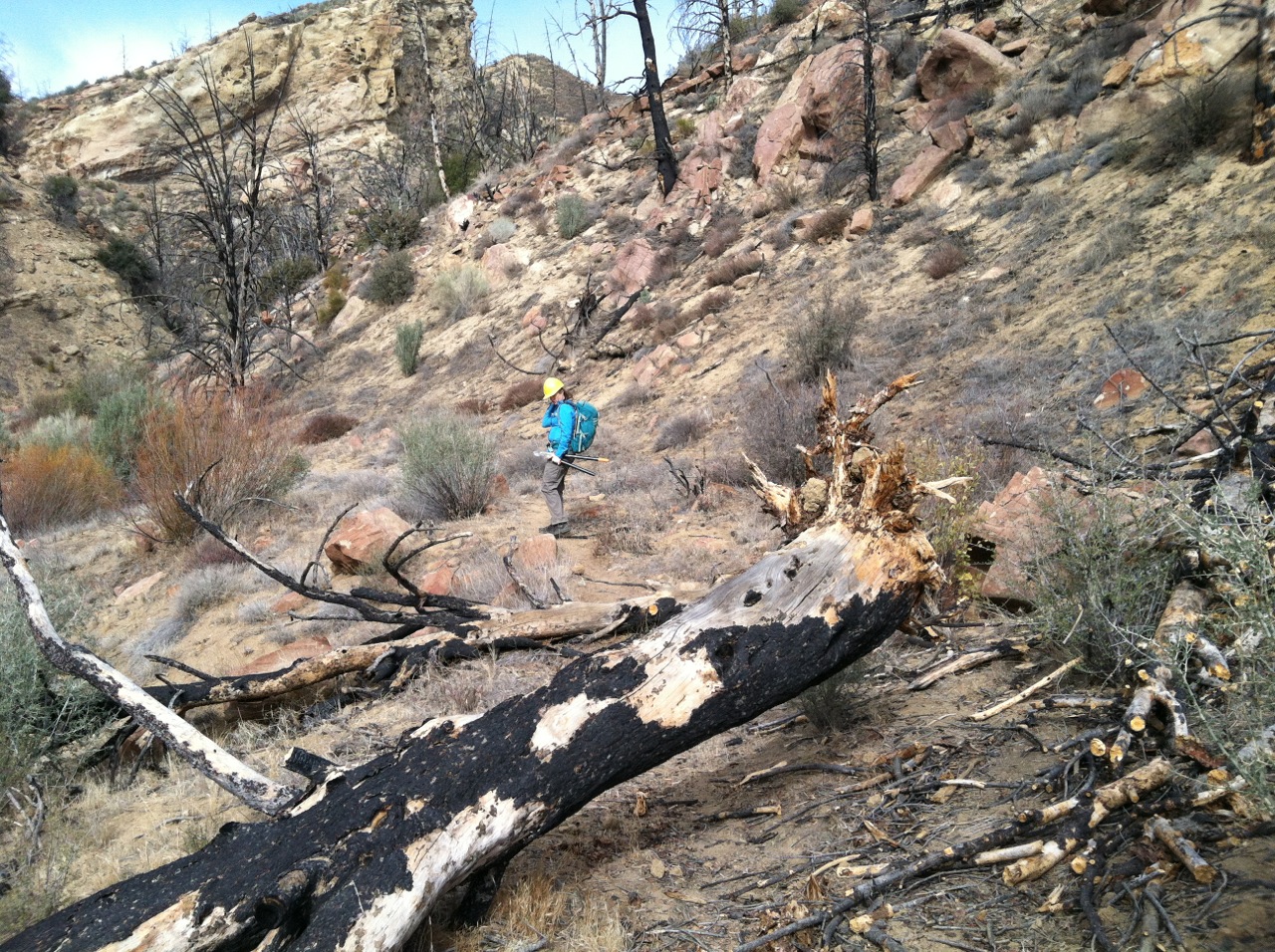
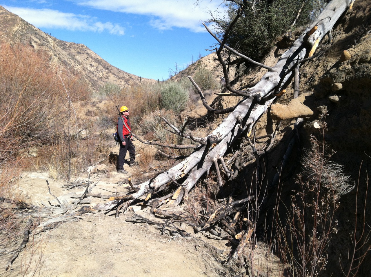
| Trail description: | From the Hwy 33 the first 1/4 mi trail not clearly defined but cross drainage and head up Bear Canyon until finding more defined tread. Trail easy to follow up to wilderness boundary and then dropping down into Deal Cyn. Heading west/northwest down Deal Cyn trail is overgrown and brushy. Some flagging but in other places no discernible trail for approx 1.5 miles until canyon starts to narrow and flagging picks up again. Trail typically can be found on east side of canyon floor. Numerous downed trees cause walk arounds. Trail is easy to follow for approx 1.5 miles above Deal Camp, but not stock passable. Trickle of flowing water in Deal Creek. Deal Camp to Rancho Nuevo Trailhead is in excellent condition. 3 new fire rings at Rancho Nuevo Campground. |
| Mode of transport: | Hike |
| Trail condition: | Hard to follow |
| Condition details: | thru hike from Hwy 33 up Bear Cyn, west & north on Deal Cyn to Deal Camp & exit Rancho Nuevo campground |
Deal Trail Survey - 11-03-2017 - by M. Jones| Link: | Deal Trail |
| Date: | 11-03-2017 |
| Surveyor Name: | M. Jones |
| Trail description: | Overall trail is in good condition, a few minor areas where it is hard to find trail. Tree blocking trail about a 1/2 mile from Deal Canyon Junction Camp:  N34° 41.002' W119° 25.164' @ 3800ft  |
| Mode of transport: | Hike |
| Trail condition: | Needs some work |
| Condition details: | There are a few pools of water along trail |
| Images: | Tree blocking trail |
Deal Trail Survey - 03-18-2017 - by Los Padres Forest Association| Link: | Deal Trail |
| Date: | 03-18-2017 |
| Surveyor Name: | Los Padres Forest Association |
| Trail description: | Boy Scout David Jones installed a new Dick Smith Wilderness sign at the wilderness junction along the Deal Trail. Â This was part of an Eagle Scout project which also included repainting Los Padres Forest signs along Hwy 33. Â Very cool project, great work David and thanks also to MPRD super volunteer Mark Subbotin for coordinating the effort. |
| Mode of transport: | Hike |
| Trail condition: | Needs some work |
| Images: | |
Deal Trail Survey - 03-03-2017 - by Mike Maki| Link: | Deal Trail |
| Date: | 03-03-2017 |
| Surveyor Name: | Mike Maki |
| Trail description: | We did a clockwise loop up Deal Tr and down Rancho Nuevo and 3 miles on Hwy 33. Most of the work the Boy Scouts did Feb 5 in Bear Cyn held very well. Great work. A few trees down and stream crossings washed out but not a problem to find route. Bryan Conant's description of the trail is right on on his map. Easy to follow to the saddle/wilderness boundary then a little more route finding is required. More of the same for the wilderness section, washed out crossings and a few tress down but if you take your time and look you can usually find the trail. Many more pics here. |
| Mode of transport: | Hike |
| Trail condition: | Needs some work |
| Condition details: | Not bad. Some down trees and wash outs. |
| Images: | Easy tree to get around One of the wash outs. Not too many. Mostly at stream crossings. Good flowing water! What happens when a culvert gets clogged. Actually surprised to find this culvert up here. |
Deal Trail Survey - 02-05-2017 - by Craig R. Carey| Link: | Deal Trail |
| Date: | 02-05-2017 |
| Surveyor Name: | Craig R. Carey |
| Trail description: | Worked the Bear Cyn section of the Deal Trail with Mark Subbotin's hard-hitting Super Bowl crew and Boy Scout Troop 111. Several trees removed, some erosion control, treadwork, and much clipping. A great weekend and great weather. |
| Mode of transport: | Hike |
| Trail condition: | Good shape and easy to follow |
| Images: | |
Deal Trail Survey - 05-14-2016 - by Josh Henderson| Link: | Deal Trail |
| Date: | 05-14-2016 |
| Surveyor Name: | Josh Henderson |
| Trail description: | This was my first time trying this trail. It's possible that I just wasn't looking in the right place but I couldn't follow this trail more than a couple of hundred yards. I saw the "Deal Connector Trail" further south on 33 which looked like a better bet, but by that time I'd just decided to call it a day. |
| Mode of transport: | Hike |
| Trail condition: | Non existent |
| Condition details: | First Timer |
Deal Trail Survey - 02-02-2014 - by Subbotin| Link: | Deal Trail |
| Date: | 02-02-2014 |
| Surveyor Name: | Subbotin |
| Trail description: | For good description of recent trail conditions, see http://valhikes.blogspot.com/2014/02/deal-trail.html |
| Mode of transport: | Hike |
| Trail condition: | Needs some work |
| Condition details: | Trail has recently been brushed and logged by UTMC (http://www.unitedtrailmaintainers.org/photos.aspx) from Hwy 33 to wilderness boundary. From there to Deal Camp general brushing needed but trail generally easy to follow. |
| Number of trees down: | 2 |
| Images: | |
 Survey / Report Form - Please click this box to open the form.