 Use Marker Groups
 Wolf 2002
Piru 2003
Day 2006
Zaca 2007
Gap 2008
La Brea 2009

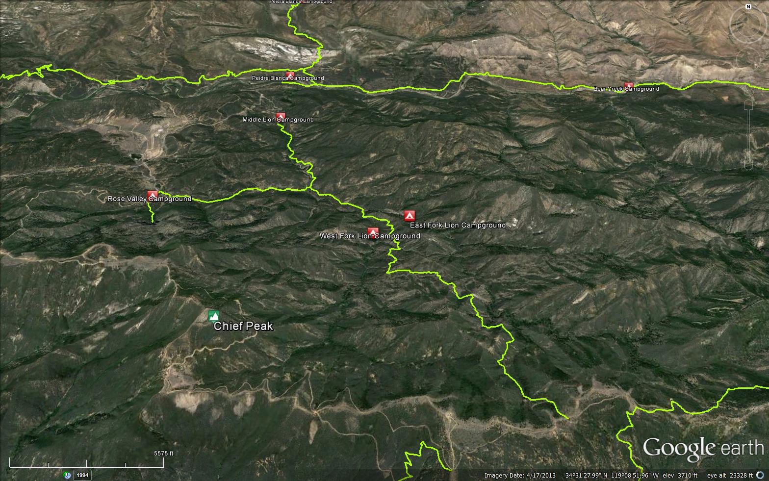
Drive 14.8 miles north of Ojai on Highway 33. The trail starts at the back of Middle Lion Campground in the Rose Valley Recreation Area where it immediately crosses the stream. You will reach two trail junctions along the way. After 1.3 miles you will reach the Rose-Lion Connector Trail (22W16) on the right. After 0.6 miles you can take side trails to East Fork Lion Camp, which is within the Sespe Wilderness, or West Fork Lion Camp. The main trail continues 3.6 miles to Nordhoff Ridge for spectacular views.
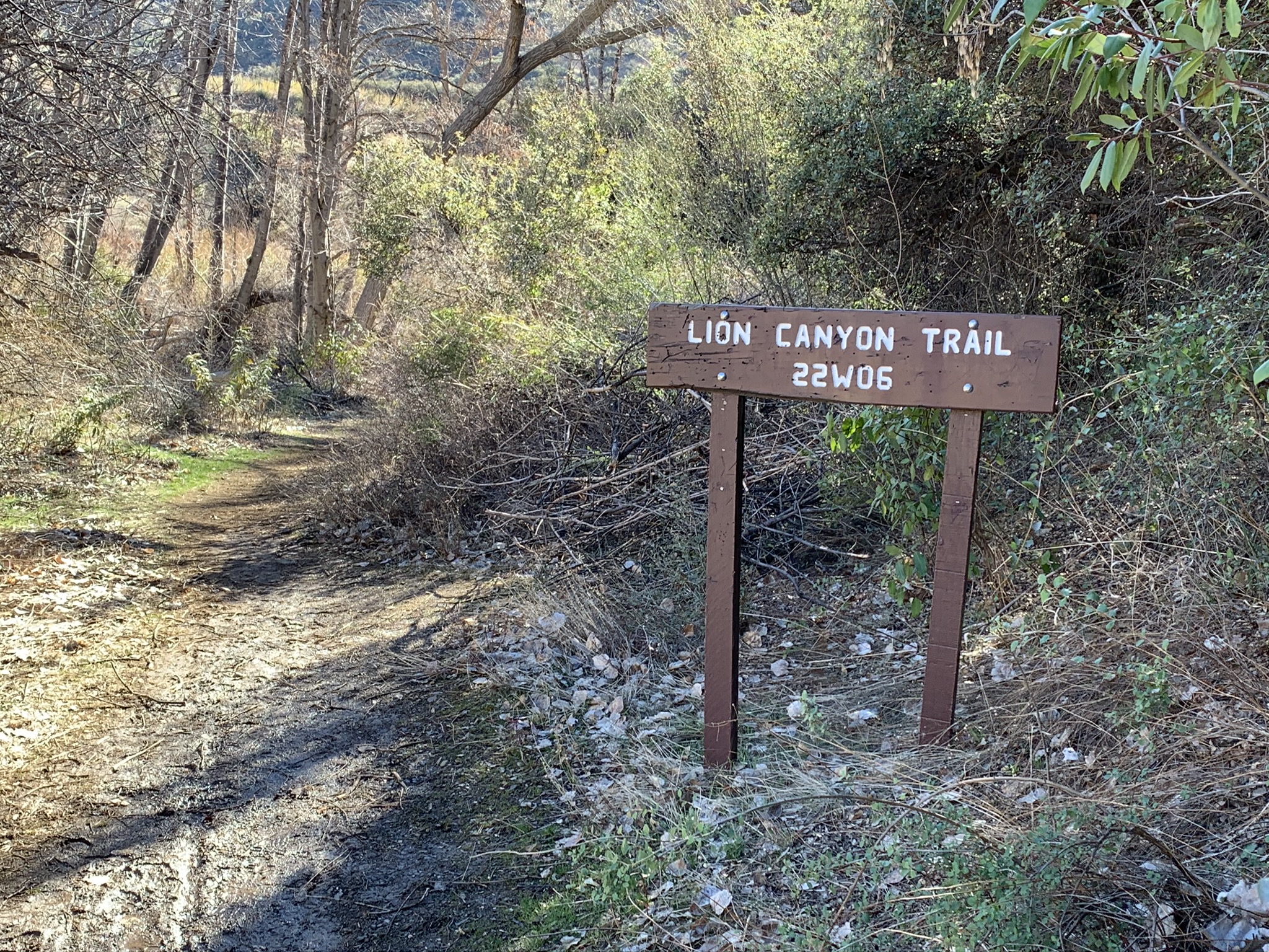


 Lion Canyon Trail Survey - 03-11-2026 - by Daniel J. Hall
| Link: | Lion Canyon Trail |
| Date: | 03-11-2026 |
| Surveyor Name: | Daniel J. Hall |
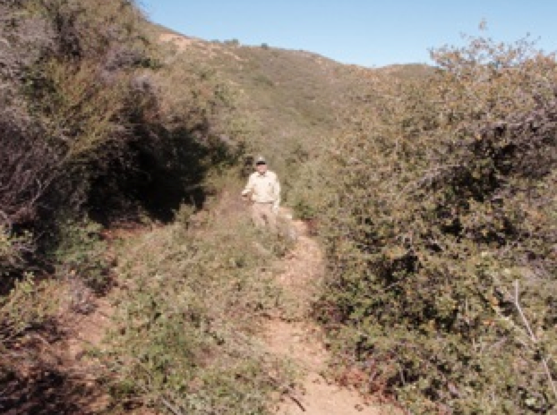
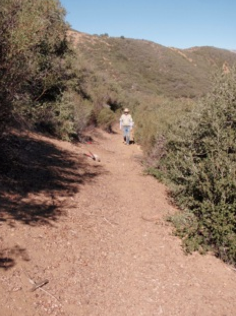
| Trail description: | From the trailhead at Middle Lion Campground to the junction for East & West Fork Lion Camps, the trail is in generally good condition and easy to follow. Only minor blowdowns near trailhead to hike over. Regarding the spur trail to West Fork Lion Camp, we went only about half way to the camp as impassibility became an issue. The trail is bad in all respects. Now has new flagging to where we stopped. Regarding the spur trail to East Fork Lion Camp, it is in mostly good condition, but about a quarter mile of it is sketchy to nonexistent. It runs across a channelized floodplain and high water resulted in fallen trees, large obstructions, extensive erosion and lots of tall brush grown over the trail. It is, however, safely passable, but just slow. Watch for the new flagging. Regarding the main trail continuing on up towards Nordhoff Ridge, I went only to where it crosses over into the East Fork Lion drainage (maybe 2.5 miles). That portion of the trail is in generally good condition, although there are a few broken/eroded spots that might slow you down. For more detail, see captioned photos at https://tinyurl.com/2ynjhu7z |
| Mode of transport: | Hike |
| Trail condition: | Good shape and easy to follow |
Lion Canyon Trail Survey - 05-25-2025 - by Omar Eff| Link: | Lion Canyon Trail |
| Date: | 05-25-2025 |
| Surveyor Name: | Omar Eff |
| Trail description: | The trail is generally great condition from Middle Lion Camp, except for dense vegetation immediately at the trailhead and then again in the last section between Four Points Junction and East Fork Camp. Immediately after the fork, there was a jungle of dense vegetation, with lots of thorns, and then the trail was difficult to follow through dry creek bed. |
| Mode of transport: | Hike |
| Trail condition: | Needs some work |
| Condition details: | Clear and easy up until just past the Four Points Junction |
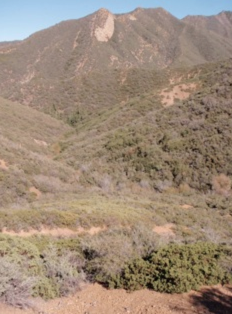
| Images: | Piedra Blanca in the background Jungle between Four Points Junction and East Fork camp |
Lion Canyon Trail Survey - 03-22-2025 - by Rick Hayes| Link: | Lion Canyon Trail |
| Date: | 03-22-2025 |
| Surveyor Name: | Rick Hayes |
| Trail description: | Hiked from Middle Lion camp to Nordoff Ridge road. Trail is in great shape and easy to follow. Did whole thing in shorts and T-shirt, no brush. Last water is at the junction of East Lion and West Lion camp. Old melted irrigation tubing at base East Lion falls. |
| Mode of transport: | Hike |
| Trail condition: | Good shape and easy to follow |
Lion Canyon Trail Survey - 02-24-2025 - by Los Padres Forest Association| Link: | Lion Canyon Trail |
| Date: | 02-24-2025 |
| Surveyor Name: | Los Padres Forest Association |
| Trail description: | LPFA cut out the jumble of downed trees about .5 miles above Middle Lion, as well as brushing the beginnings of the trails to West/East Lion Camps to make them more obvious. The rest of the trail is looking OK, a little brushy here and there but definitely open for business! |
| Mode of transport: | Hike |
| Trail condition: | Needs some work |
| Images: | |
Lion Canyon Trail Survey - 02-15-2025 - by Antonio Calderon| Link: | Lion Canyon Trail |
| Date: | 02-15-2025 |
| Surveyor Name: | Antonio Calderon |
| Mode of transport: | Hike |
| Trail condition: | Needs some work |
| Images: | East fork lion falls |
Lion Canyon Trail Survey - 11-30-2024 - by Jeremy Scarlett| Link: | Lion Canyon Trail |
| Date: | 11-30-2024 |
| Surveyor Name: | Jeremy Scarlett |
| Trail description: | Beautiful day on the Lion Canyon trail. Have done this one many times, but fall is so pretty with the leaves changing. Did the West Falls this time, found 3 of the 4 camps. Saw no one on the trail. Little brushy in spots but the tread was easy to follow. Wear pants and long sleeves for the ticks. Saw some good sized fish in the main pool. Was fun to explore above the falls. |
| Mode of transport: | Hike |
| Trail condition: | Good shape and easy to follow |
| Images: | |
Lion Canyon Trail Survey - 04-27-2024 - by Andy| Link: | Lion Canyon Trail |
| Date: | 04-27-2024 |
| Surveyor Name: | Andy |
| Trail description: | Went up to Topa Topa from Rose/Lion connector. Trail was in great condition with recent work above the campsites. There is an unmarked spring near the top (5000 ft), perfect timing for filtering and a break. |
| Mode of transport: | Hike |
| Trail condition: | Good shape and easy to follow |
Lion Canyon Trail Survey - 04-01-2024 - by Neal L| Link: | Lion Canyon Trail |
| Date: | 04-01-2024 |
| Surveyor Name: | Neal L |
| Trail description: | I got on this trail from the Rose-Lion Connector and headed to East Fork Camp. I missed the 4-way junction, following a trail on my Gaia.gps app that stayed against the north wall of the canyon. I ran into a wall of brush and crossed the East Fork of the creek to find the trail. I spent about 30 minutes going up various paths that all ended in thick brush. I could not find the trail even after reaching the opposite wall of the canyon. I gave up and turned around, coming upon the trail that led me to the junction. I went to West Fork Camp to stay the night and had no problem following that trail. It is hard to say how much of this was my fault, my apps fault or the trail being overgrown and difficult to follow after the recent storms. |
| Mode of transport: | Hike |
| Trail condition: | Hard to follow |
| Condition details: | Section from Rose-Lion Connector to East Fork Camp |
Lion Canyon Trail Survey - 03-31-2024 - by Daniel J. Hall| Link: | Lion Canyon Trail |
| Date: | 03-31-2024 |
| Surveyor Name: | Daniel J. Hall |
| Trail description: | From trailhead at Middle Lion Campground to the junction for East Fork Lion Camp, the trail is in generally good shape and easy to follow. However, there are 2 large boulders in the trail and a few minor erosion areas developing, and it is a little hard to find in the 100 yards of floodplain before the noted trail junction, but those conditions only slow hikers a little. Stock probably cannot get around the 2 boulders. Regarding the spur trail to East Fork Lion Camp, about a quarter mile of it is sketchy to nonexistent. It runs across a floodplain and the high water resulted in fallen trees, large obstructions and erosion, while brush has also grown over the trail. Real slow finding the way. For more detail see https://tinyurl.com/2doga89o |
| Mode of transport: | Hike |
| Trail condition: | Good shape and easy to follow |
Lion Canyon Trail Survey - 12-17-2022 - by Dave Chappelle| Link: | Lion Canyon Trail |
| Date: | 12-17-2022 |
| Surveyor Name: | Dave Chappelle |
| Trail description: | I hiked this trail twice back in 2014/2015 and it was ok, but I was hesitant to ride it on my bike back then. Right now trail is fucking awesome! Much thanks to LPFA for all the hard work they have put into making this trail one of the best trails in the Ojai backcountry! |
| Mode of transport: | Bicycle |
| Trail condition: | Good shape and easy to follow |
| Images: | |
Lion Canyon Trail Survey - 07-27-2022 - by Los Padres Forest Association| Link: | Lion Canyon Trail |
| Date: | 07-27-2022 |
| Surveyor Name: | Los Padres Forest Association |
| Trail description: | LPFA volunteers cleared approximately 25 downed trees along the lower mile of the trail as you climb up from Middle Lion Campground. The trail is getting overgrown again but is now cleared of downed trees. Photos of the project are shown below: https://www.instagram.com/p/CgkKbn0JXaH/ |
| Mode of transport: | Array |
| Trail condition: | Good shape and easy to follow |
Lion Canyon Trail Survey - 06-04-2022 - by Anonymous Surveyor| Link: | Lion Canyon Trail |
| Date: | 06-04-2022 |
| Surveyor Name: | Anonymous Surveyor |
| Trail description: | East Fork Lion Trail is easy to follow is some places, but needs work and is hard to follow in others, esp. as it goes through brushy creek bottom areas. Easy to start going onto false trails and having to "find" the proper trail. This makes maintaining the true trail harder and harder as more and more hikers make their own trails. Certainly not possible to get lost as you can make your way through the narrow canyon either way, but frustrating. |
| Mode of transport: | Hike |
| Trail condition: | Hard to follow |
Lion Canyon Trail Survey - 06-04-2022 - by Addison Jerlow| Link: | Lion Canyon Trail |
| Date: | 06-04-2022 |
| Surveyor Name: | Addison Jerlow |
| Trail description: | Great shape all the way. Brushy at the beginning until leaving the creek. Best, easiest to access water right after lower trailhead. Water in crossing on Rose Valley connector and West Fork Camp as well. Did not check out East Fork. |
| Mode of transport: | Hike |
| Trail condition: | Good shape and easy to follow |
Lion Canyon Trail Survey - 04-03-2021 - by Los Padres Forest Association| Link: | Lion Canyon Trail |
| Date: | 04-03-2021 |
| Surveyor Name: | Los Padres Forest Association |
| Trail description: | The LPFA Trail Crew wrapped up two weeks of Thomas Fire Trail Restoration work on the Lion Canyon spending one week working from Nordhoff and one week working from Middle Lion. We were able to fix the worst slides and erosion gullies on the top of the trail and brush most of the lower trail. There are a few spots that remain in the middle as you start the climb up from the Lion Camps but otherwise the trail looks great. Enjoy..... Some IG photos of the work: https://www.instagram.com/p/CMf01fFlFFE/ |
| Mode of transport: | Array |
| Trail condition: | Good shape and easy to follow |
Lion Canyon Trail Survey - 04-16-2021 - by Tom Fritz| Link: | Lion Canyon Trail |
| Date: | 04-16-2021 |
| Surveyor Name: | Tom Fritz |
| Trail description: | Started from Middle Lions about 2pm. Trail is in pretty good shape. Checked out East Fork Lions: water flow was good. Campsite was clean. Then checked out West Fork Lions: water flow was good. Campsite and alternate across the creek were in good shape. Spent the night in the alternate camp. 0800 next morning, hiked up to Nordhoff Ridge. I appreciate the work that had been done on the large slide area. Watch the copious poodle-dog brush the last mile toward the top! Overall, the trail is in fine shape. |
| Mode of transport: | Hike |
| Trail condition: | Good shape and easy to follow |
Lion Canyon Trail Survey - 08-24-2020 - by Jim Kenney| Link: | Lion Canyon Trail |
| Date: | 08-24-2020 |
| Surveyor Name: | Jim Kenney |
| Trail description: | Started at the parking lot. We got off trail before the creek and crossed as best we could. We found the trail and took it to West camp. The trail was easy to follow and only minor difficulty south of the west camp up to the falls. The camp looked in great shape. We hikes down to the trail junction and took off to the east camp. The trail is easy to follow for the most part. There is about a 200 foot section that is overgrown, but pretty easy to navigate. Took the trail to the camp, and then to the falls. I removed some rocks that had formed an unnatural dam in the creek. The water was amazing and i saw a 8-10 inch trout swimming around.  |
| Mode of transport: | Hike |
| Trail condition: | Needs some work |
| Condition details: | Lion Canyon to East and West camps |
Lion Canyon Trail Survey - 06-12-2020 - by David Cairngorm| Link: | Lion Canyon Trail |
| Date: | 06-12-2020 |
| Surveyor Name: | David Cairngorm |
| Trail description: | A couple of problems that I blame on low usage this year: The top mile or so is loaded with poodle dog bush, which I'm told is more poisonous than PO, and will attach to your clothes too (I'm probably going to toss this fleecy jacket). At a couple of places hikers have detoured around it. At quite a few other places I could only get through with arms above head (I'm 5'11"). Do not wear shorts. And then: although I've used the Rose Lion Connector trail several times, I couldn't find the intersection today (if you find the old signpost, you're doing better than I did), and had to make a serious fight through trees at the best point I could find. Once over the creek, the crossover trail was hard to locate. Luckily the flat land looked the same as usual and I knew the direction from there, without which I'd never have guessed the little-used route up the hill. Apart from all that - the first half of my day had been perfect, climbing straight up from Rose Valley Campsite, and an easy hike along the Nordhoff Ridge trail. |
| Mode of transport: | Hike |
| Trail condition: | Needs some work |
Lion Canyon Trail Survey - 06-06-2020 - by Anonymous Surveyor| Link: | Lion Canyon Trail |
| Date: | 06-06-2020 |
| Surveyor Name: | Anonymous Surveyor |
| Trail description: | Took this trail today. Easy to find single track trail. Easy to moderate hike. Crosses stream at the start and follows it much if the distance. A lot of the trail is overgrown with the beautiful wildflowers and shrubs, watch your feet closely for snakes and long sleeve shirts helpful. Pretty easy hike most of the way and could even jog some of it. At intersection of East and west trail the west trail is not visible. The forward trail to ridge is super overgrown as well. I’ll pack a machete next time!! Great weather today nice to see little fish in the stream. |
| Mode of transport: | Hike |
| Trail condition: | Needs some work |
| Condition details: | Easy to follow trail but several overgrown areas |
| Images: | |
Lion Canyon Trail Survey - 05-09-2020 - by Anonymous Surveyor| Link: | Lion Canyon Trail |
| Date: | 05-09-2020 |
| Surveyor Name: | Anonymous Surveyor |
| Trail description: | Trail seemed to be in fine condition. The east fork, where it crosses the stream again needs some work. Once across, be careful at the top of the embankment as the branches from a bush clearing all are slippery and inline with the direction you walk. |
| Mode of transport: | Hike |
| Trail condition: | Good shape and easy to follow |
Lion Canyon Trail Survey - 02-16-2020 - by Christopher P. Lord| Link: | Lion Canyon Trail |
| Date: | 02-16-2020 |
| Surveyor Name: | Christopher P. Lord |
| Trail description: | From Middle Lion to both the East and West Fork Camps 22W06 is probably in the best shape that it's been in awhile. Both falls were flowing nicely and water was readily available along the trail. I did note one downed tree just before reaching the West fork Camp. A full write up can be found at the link below. |
| Mode of transport: | Hike |
| Trail condition: | Good shape and easy to follow |
| Images: | |
Lion Canyon Trail Survey - 01-01-2020 - by Antonio Calderon| Link: | Lion Canyon Trail |
| Date: | 01-01-2020 |
| Surveyor Name: | Antonio Calderon |
| Trail description: | From trailhead at Middle Lion Campground to Rose/lion connector there are several blowdowns. Had to crawl under  or climb over these areas. From there the trail is clear to west fork / East fork camp junction. Trail to East fork camp  is a bit brushy but easy to follow. Trail to west fork camp is overgrown with poison ivy and poodle dog bush but the tread is all there. Creek was flowing strong. Sections of the trail still had some snow. |
| Mode of transport: | Hike |
| Trail condition: | Needs some work |
| Images: | One of several blowdowns Another blowdown Section with some snow |
Lion Canyon Trail Survey - 09-19-2019 - by RJWean| Link: | Lion Canyon Trail |
| Date: | 09-19-2019 |
| Surveyor Name: | RJWean |
| Trail description: | From Middle Lion to Rose Valley connector tread is in pretty good condition. It is getting a bit brushy in spots. From connector trail to junction for east camp,west camp and Nordhoff Ridge it is very brushy.The trail to east camp is marked with pink ribbon which seemed to sometimes disappear leaving one to take their best guess as to which way to go. Brush here is very thick, but as long as you keep heading up canyon you will eventually find yourself at the east fork camp,which is in very good shape. Creek is flowing strongly still! |
| Mode of transport: | Hike |
| Trail condition: | Needs some work |
Lion Canyon Trail Survey - 09-08-2019 - by Katie G| Link: | Lion Canyon Trail |
| Date: | 09-08-2019 |
| Surveyor Name: | Katie G |
| Trail description: | Was great to reach the ridge from this side of the mountain. We found the beginning of the trail really quickly thanks to these posts. Bushwack up the west side of bank for a quick second and look for the huge fallen tree across the creek. We opted just to rock hop as it led to the trailhead more easily. Most of the trail was very easy to follow, even tho there was a lot of overgrowth. We accidentally went up to West Fork Camp because we missed the Lion Canyon through-trail at the sign. I couldn't even see the East Fork Camp trail, albeit I didn't try very hard. At the sign, look for the pink ribbons tied to the foliage and bushwack for about 15 ft until you get to the side of the hill to start your ascent to stay on the trail. Trail to West Fork Camp was pretty overgrown. Lots of bulldozing through overgrowth required, even tho the trail was mostly easy to follow. You can't get to water until you hit the camp unless you feel like wading through Poodle Dog. Creek is running nicely. Did not have the chance to make it to the waterfall. LOTS of Poodle Dog brush alongside the trail along the traverse. Be careful! None of the springs had visible water once you leave the canyon... to be expected this late in the summer/fall. Also, definitely some bear scat along the first portion of the trail in the Canyon. Keep those vocal chords going! |
| Mode of transport: | Hike |
| Trail condition: | Needs some work |
| Condition details: | Overgrown |
Lion Canyon Trail Survey - 01-10-2019 - by Los Padres Forest Assocation| Link: | Lion Canyon Trail |
| Date: | 01-10-2019 |
| Surveyor Name: | Los Padres Forest Assocation |
| Trail description: | Lion Canyon trail heads out from Middle Lion Campground. We heard reports from a few hikers that day that the creek crossing in the first 50 yards was difficult to find. You should cross the creek almost right away. Look for cairns on the other side of the creek denoting where to cross. Newly installed trail signs should help with navigation as well. The overall trail has held together well after the Thomas fire and following rains. Some minor sliding has occurred causing the bench to shrink to about 2ft wide in sections. Watch out for a false edge and stick to hiking on the inside of the trail. This is not ideal for horses, but hikers will do just fine. There is poodle dog (the plant known to be a skin irritant) popping up along the entire trail corridor which could cause some issues as it grows. For now it's barely at ankle height.  Water is flowing and there are even springs on the side of the trail around mile 4. Enjoy! |
| Mode of transport: | Hike |
| Trail condition: | Needs some work |
| Condition details: | Beautiful spot with a view of snowy peaks (in January) |
| Images: | Beautiful trail signs! Poodle dog... watch out. Water flowing into a spring around mile 4 Narrow bench. This photo makes it look worse than it is, but still not great. The crossing in the first 50 yards. |
Lion Canyon Trail Survey - 05-28-2018 - by James Wapotich| Link: | Lion Canyon Trail |
| Date: | 05-28-2018 |
| Surveyor Name: | James Wapotich |
| Trail description: | I hiked this trail up to the trail juncture with East and West Fork Lion Camps and also hiked to both camps. Lion Canyon Trail post Thomas Fire is in good shape and remains relatively easy to hike. The few places with some ravel across the trail can easily be cleared and don't represent a significant barrier to hiking. There are no down trees across the trail that I recall. The hillsides seem stark in the absence of thick chaparral and there is little shade along the trail, but there is plenty of new growth. Wildflowers abound and many of the chaparral plants are sprouting forth from their root burls. The creek crossing just before the juncture to East and West Fork is a little confusing in that there's no longer the fully grown willow defining the traveled route and newly deposited silt has obscured parts of the trail. This is also true through that first section on the way to East Fork Lion. Where the trail once meandered through the creek and willows, it's a little less obvious, requiring a bit of sense memory to follow the route, which itself has morphed over time. In fact, now would be a great time to go in a craft a simpler route. The trail to West Fork Lion has a similar section where the creek has flowed over portions of the trail. The trail was easier to locate once I remembered that it basically follows the east side of the flood plain before getting up on the bank. The trails are otherwise relatively easy to follow. Reports for each of the camps are on their respective listings. |
| Mode of transport: | Hike |
| Trail condition: | Needs some work |
| Images: | |
Lion Canyon Trail Survey - 03-28-2017 - by Torrey Beckstrand| Link: | Lion Canyon Trail |
| Date: | 03-28-2017 |
| Surveyor Name: | Torrey Beckstrand |
| Trail description: | Rose Lion Connector needs some brushing and some tread work, water bar clean out. From the junction to the fork there is brushing needed, mainly sections of wild rose. From the junction up to east fork camp. there is one tree blocking stock. there is also some tread work that is needed. |
| Mode of transport: | Hike |
| Trail condition: | Needs some work |
| Condition details: | Hiked into East Fork Lion from Rose/Lion Connector |
| Images: | Log on the trail located at 34° 31.830' N, 119° 08.967' W |
Lion Canyon Trail Survey - 03-17-2017 - by Daniel J. Hall| Link: | Lion Canyon Trail |
| Date: | 03-17-2017 |
| Surveyor Name: | Daniel J. Hall |
| Trail description: | We hiked the trail from the top down to Middle Lion Camp, with a stop for the night at East Fork (which had flowing water). The tread was good, especially considering the February storms. No brush issues. One large blowdown about half a mile above Middle Lion Camp which hikers can pass, but stock probably cannot. Very little work needed, overall. Regarding the spur trail to East Fork Camp, portions of it are in a streambed and it took a beating recently; all is passable by hikers, but probably not stock because of one blowdown across the trail. |
| Mode of transport: | Hike |
| Trail condition: | Needs some work |
Lion Canyon Trail Survey - 02-14-2017 - by Kevin Fox| Link: | Lion Canyon Trail |
| Date: | 02-14-2017 |
| Surveyor Name: | Kevin Fox |
| Trail description: | Trail is in good shape with water available in a few places. Â No down trees to speak of. Â Unfortunately someone took a horse up this trail in recent wet weather and did a bit of damage to the tread. Â It's nothing that makes it impassible but it is a shame that this damage could have been avoided with a little patience. |
| Mode of transport: | Hike |
| Trail condition: | Good shape and easy to follow |
Lion Canyon Trail Survey - 09-25-2016 - by Los Padres Forest Association| Link: | Lion Canyon Trail |
| Date: | 09-25-2016 |
| Surveyor Name: | Los Padres Forest Association |
| Trail description: | LPFA partnered with the Forest Service, Ventura based Boy Scout Troop 111 and REI to host a National Public Lands Day project on September 23-25, 2016. Â We accomplished working the trail from Middle Lion Camp up to both East and West Lion Camps. NOTE: We did not work the first crossing just above Middle Lion. Â The first crossing is confusing with an old road and multiple user-trails making it tough to determine which trail is which. Â We are hoping to head back out there and finish it up sometime soon. Check out FB for more information about the project: https://www.facebook.com/LosPadresForestAssociation/posts/616355325156062 |
| Mode of transport: | Array |
| Trail condition: | Good shape and easy to follow |
Lion Canyon Trail Survey - 12-07-2016 - by Hikerdawg| Link: | Lion Canyon Trail |
| Date: | 12-07-2016 |
| Surveyor Name: | Hikerdawg |
| Trail description: | Started the hike at the campground. Â The trail is clearly marked up to the first creek crossing. Â There are a few side trails, but across the creek it becomes more pronounced. Â The water in the creek is flowing near the crossing and is quite cool as i stepped off a rock and into it just to verify my thoughts. Â The overall trail condition is good with a healthy dose of poison oak. Â https://www.facebook.com/Hikerdawg/videos/10212169761665774/ |
| Mode of transport: | Hike |
| Trail condition: | Good shape and easy to follow |
Lion Canyon Trail Survey - 11-21-2016 - by Anonymous Surveyor| Link: | Lion Canyon Trail |
| Date: | 11-21-2016 |
| Surveyor Name: | Anonymous Surveyor |
| Mode of transport: | Hike |
| Trail condition: | Good shape and easy to follow |
Lion Canyon Trail Survey - 09-21-2016 - by Los Padres Forest Association| Link: | Lion Canyon Trail |
| Date: | 09-21-2016 |
| Surveyor Name: | Los Padres Forest Association |
| Trail description: | Trail report from the Middle Lion Campground to the two backpackers camps in advance of an upcoming trail project for National Public Lands Day: https://www.arcgis.com/apps/MapTour/index.html?appid=245a4bd1fe69454ca730e16b385ea721 |
| Mode of transport: | Hike |
| Trail condition: | Good shape and easy to follow |
Lion Canyon Trail Survey - 03-31-2016 - by Shaddus Maximus/Los Padres Forest Association| Link: | Lion Canyon Trail |
| Date: | 03-31-2016 |
| Surveyor Name: | Shaddus Maximus/Los Padres Forest Association |
| Mode of transport: | Hike |
| Trail condition: | Good shape and easy to follow |
Lion Canyon Trail Survey - 02-12-2016 - by JO| Link: | Lion Canyon Trail |
| Date: | 02-12-2016 |
| Surveyor Name: | JO |
| Trail description: | Started at Nordoff Ridge and came down the trail. Â Trail is in excellent condition. Â It got narrow in a few spots, but no downfalls. |
| Mode of transport: | Hike |
| Trail condition: | Good shape and easy to follow |
| Images: | below nordoff ridge on Lion Canyon trail. Sespe drainage in background. Lion Canyon trail tread |
Lion Canyon Trail Survey - 10-30-2015 - by Los Padres Forest Association| Link: | Lion Canyon Trail |
| Date: | 10-30-2015 |
| Surveyor Name: | Los Padres Forest Association |
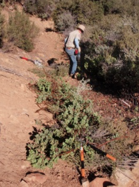
| Trail description: | Super volunteers Ranger Rik and Mickey spent a day clearing the top section of the Lion Canyon Trail above Ojai. Â They brushed the top 0.5 miles of trail. Â More work needed below but the trail is very VERY passable by LP standards. |
| Mode of transport: | Array |
| Trail condition: | Good shape and easy to follow |
| Images: | Brushing, photo Rik Before, photo Rik After, photo Rik Awesome views into the Sespe, photo Rik |
Lion Canyon Trail Survey - 01-06-2015 - by Los Padres Forest Association| Link: | Lion Canyon Trail |
| Date: | 01-06-2015 |
| Surveyor Name: | Los Padres Forest Association |
| Trail description: | The Ojai Ranger District organized a brushing project along the Lion Canyon Trail. Â They cleared the trail up towards West Fork camp. |
| Mode of transport: | Array |
| Trail condition: | Good shape and easy to follow |
| Images: | Photo Ranger Heidi, trail looking good |
Lion Canyon Trail Survey - 11-09-2014 - by Bryan Conant| Link: | Lion Canyon Trail |
| Date: | 11-09-2014 |
| Surveyor Name: | Bryan Conant |
| Trail description: | Great trail! Â One of my favorites. Â I love how it was designed and never seems to get too steep. Â The trail is in good shape. Â There was a lot of minor water damage as a result of the lat heavy rain we got a few weeks ago. Â The upper section is in fine shape, some work needed but nothing major. Â The middle section from the camps down to the Connector Trail is pretty brushy and could use a work project. |
| Mode of transport: | Bicycle |
| Trail condition: | Needs some work |
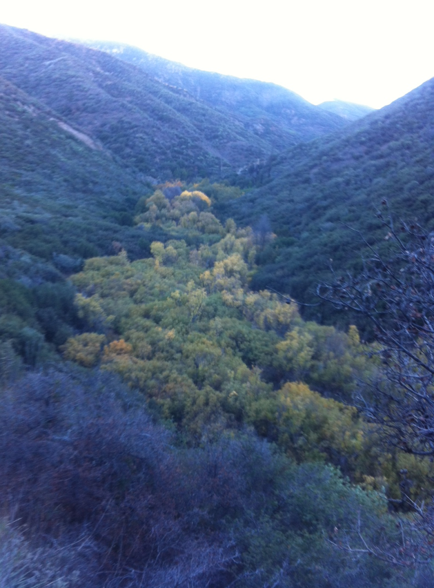
| Images: | Fall in the Air and on the Trees |
Lion Canyon Trail Survey - 05-17-2014 - by Hike Los Padres| Link: | Lion Canyon Trail |
| Date: | 05-17-2014 |
| Surveyor Name: | Hike Los Padres |
| Trail description: | Water is flowing at Middle Lion Camp and perhaps a half mile up-canyon before it goes dry. Â Trail was worked multiple times over the past months with the Ojai Ranger District 1st Saturday trail program. |
| Trail condition: | Good shape and easy to follow |
 Survey / Report Form - Please click this box to open the form.