 Use Marker Groups
 Wolf 2002
Piru 2003
Day 2006
Zaca 2007
Gap 2008
La Brea 2009

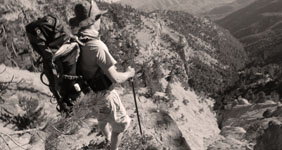
1,257 Miles of Trails on 1,762,400 Acres, with 875,000 Acres of Protected Wilderness to Explore.
Thank you for taking the time to visit the Hike Los Padres Community. This website was created with the mission of being a source of shared information on trails, camps, and locations across the entire Northern and Southern portions of the Los Padres National Forest. The more information we all share and catalog, the better we can track the conditions of the forest network and figure out what sections, trails, and locations are safe to use and which need maintenance.
A good portion of the interior of Los Padres National Forest gets very little use by the public, so any information on these areas will ensure that these places remain accessible for future generations of hikers, backpackers, trail runners, equestrians, O.H.V, hunters, cyclists, and explorers. Many of the trails listed may be unmaintained. Know your level of ability, and always remember to bring extra water.
In partnership with the Los Padres Forest Association (LPFA). The LPFA’s mission is to care for the Los Padres Forest, ensuring it thrives and remains safe and open for the people to use and enjoy. LPFA volunteers work to keep trails open, report and assess forest conditions and provide public education on how to use the forest safely. If you are interested in becoming a member or volunteering, please visit www.lpforest.org to learn more.
Location specific weather reports, recent camp and trail surveys, water data and much more.
 Los Prietos Campground Mt Pinos Campground Chula Vista Campground Manzana Schoolhouse Camp Arroyo Seco Campground
  Ballinger Route 52 OHV… Ballinger Route 23 OHV… Ballinger Route 9 OHV… Ballinger Route 53 OHV… Horseshoe Springs Spur…
 Wheeler Resi - Forest… Los Prietos - Forest… Piano Box L Ohv - Forest… Sierra Madre - Forest… Pine Canyon - Forest…
 | Location | Date ▾ | Surveyor | Water Report |
|---|---|---|---|
| Sykes Hot Springs | 10-1-1996 | Los Padres Forest Association | Flowing |
| Mono Campground | 1-1-2024 | Los Padres Forest Association | Flowing |
| Lion Den Camp | 06-14-2025 | Hitch | Trickle |
| Cottam Camp | 06-08-2025 | Lisa B | Trickle |
| Forbush Camp | 06-07-2025 | Lisa B | Trickle |
| Fish Creek Camp | 06-07-2025 | Dancebymoon | Dry |
| Rays Camp | 06-07-2025 | Dancebymoon | Flowing |
| Cottam Camp | 06-07-2025 | RJ | Stagnant |
| Big Pine Camp | 06-05-2025 | Flora K | Flowing |
| Bluff Guard Station | 06-05-2025 | Flora K | Flowing |
| Alamar Saddle Camp | 06-04-2025 | Flora K | Dry |
| Llly Meadows Camp | 06-01-2025 | Anonymous Surveyor | Trickle |
| Manzana Schoolhouse Camp | 05-30-2025 | Stephen McDaniel | Flowing |
| Ant Camp | 05-29-2025 | Holden | Flowing |
| Ant Camp | 05-29-2025 | Fisher | Flowing |
| Matias Potrero Camp | 05-26-2025 | Shaddus Maximus | Dry |
| Beartrap Camp | 05-26-2025 | Anonymous Surveyor | Flowing |
| Fishbowls Camp | 05-25-2025 | LC | Flowing |
| Lower Camuesa Camp | 05-25-2025 | Shaddus Maximus | Dry |
| East Fork Lion Camp | 05-25-2025 | Omar Eff | Flowing |
| Middle Lion Campground | 05-25-2025 | Omar Eff | Flowing |
| 19 or Nineteen Oaks Camp | 05-24-2025 | Shaddus Maximus | Flowing |
| Middle Camuesa Camp | 05-24-2025 | Shaddus Maximus | Dry |
| Madulce Camp | 05-24-2025 | Brad Marston | Flowing |
| Coldwater Camp | 05-24-2025 | Jen Smith | Flowing |
| Cottam Camp | 05-23-2025 | Dylan T | Trickle |
| Valley View Camp | 05-22-2025 | Diane Soini | Flowing |
| Lady Bug Camp | 05-22-2025 | Diane Soini | Dry |
| Upper Bear Camp | 05-19-2025 | Anonymous Surveyor | Flowing |
| Forbush Camp | 05-17-2025 | Casey Hall | Flowing |
| Mono Campground | 05-17-2025 | Casey Hall | Flowing |
| Lady Bug Camp | 05-17-2025 | Dusty Ham | Flowing |
| Oak Camp | 05-16-2025 | Michael Carter | Flowing |
| Mission Pine Basin Camp | 05-15-2025 | Dalton Beeler | Dry |
| Cedar Creek Camp | 05-11-2025 | Laura Clay | Flowing |
| Fishbowls Camp | 05-10-2025 | Dylan Belitski | Flowing |
| Happy Hunting Ground Camp | 05-04-2025 | Luna | Flowing |
| White Ledge Camp - San Rafael Wilderness | 05-03-2025 | Luna | Flowing |
| Three Mile Camp | 05-01-2025 | Anonymous Surveyor | Flowing |
| Pine Mountain Lodge Camp | 05-01-2025 | Anonymous Surveyor | Flowing |
| Haddock Camp | 04-30-2025 | Anonymous Surveyor | Flowing |
| Beartrap Camp | 04-30-2025 | Anonymous Surveyor | Flowing |
| Upper Reyes Camp | 04-30-2025 | Anonymous Surveyor | Flowing |
| Chorro Grande Camp | 04-28-2025 | Anonymous Surveyor | Trickle |
| White Ledge Camp - Red Reef Trail | 04-27-2025 | Anonymous Surveyor | Flowing |
| Oak Flat Camp | 04-26-2025 | Zach Teske | Flowing |
| Willet Camp | 04-25-2025 | Zach Teske | Flowing |
| Matias Potrero Camp | 04-19-2025 | Brian King | Dry |
| Mansfield Camp | 04-19-2025 | Randy Lahey | Flowing |
| South Fork Camp - Sisquoc | 04-19-2025 | Randy Lahey | Flowing |
| Pine Mountain Lodge Camp | 04-18-2025 | Brandon Steets | Flowing |
| Fishbowls Camp | 04-18-2025 | Brandon Steets | Flowing |
| Alcove Camp | 04-18-2025 | Randy Lahey | Trickle |
| Bear Creek Camp | 04-17-2025 | Daniel J. Hall | Flowing |
| Manzana Schoolhouse Camp | 04-15-2025 | BJ | Flowing |
| Estrella Camp | 04-12-2025 | Anonymous Surveyor | Flowing |
| Heath Camp | 04-12-2025 | Antonio Calderon | Flowing |
| South Fork Camp - Sisquoc | 04-12-2025 | Antonio Calderon | Flowing |
| Lady Bug Camp | 04-12-2025 | Tom Kelley | Flowing |
| Gridley Springs Camp | 04-06-2025 | Anonymous Surveyor | Trickle |
Please click on a report below to view the survey
 Sykes Hot Springs Survey - 10-1-1996 - by Los Padres Forest Association
| Link: | Sykes Hot Springs |
| Date: | 10-1-1996 |
| Surveyor Name: | Los Padres Forest Association |
| Camp Description: | A story about a missed chance at visiting Sykes from 1996. Worth a read: https://www.latimes.com/lifestyle/story/2025-03-03/big-sur-wildfire-threat-camping-survival-story-between-a-rock |
| Water Source: | Flowing |
| Water Source Details: | |
| Weather Conditions: |
Mono Campground Survey - 1-1-2024 - by Los Padres Forest Association| Link: | Mono Campground |
| Date: | 1-1-2024 |
| Surveyor Name: | Los Padres Forest Association |
| Camp Description: | Historic video showing the construction of the Mono Debris Dam from 1936, enjoy! https://archive.org/details/CCCAtMono1936 |
| Water Source: | Flowing |
| Water Source Details: | |
| Weather Conditions: |
Lion Den Camp Survey - 06-14-2025 - by Hitch| Link: | Lion Den Camp |
| Date: | 06-14-2025 |
| Surveyor Name: | Hitch |
| Camp Description: | Mountain lion spotted 06;00 on 6/12. He wasn’t interested in me fortunately |
| Water Source: | Trickle |
| Water Source Details: | |
| Weather Conditions: |
Cottam Camp Survey - 06-08-2025 - by Lisa B| Link: | Cottam Camp |
| Date: | 06-08-2025 |
| Surveyor Name: | Lisa B |
| Camp Description: | At Cottam there was a trickle, but verging on stagnant. We actually camped at the rock firepit a 1/4 mile or so west of Cottam proper, and there was a decent trickle behind the camp there. |
| Water Source: | Trickle |
| Water Source Details: | |
| Weather Conditions: |
Forbush Camp Survey - 06-07-2025 - by Lisa B| Link: | Forbush Camp |
| Date: | 06-07-2025 |
| Surveyor Name: | Lisa B |
| Camp Description: | Filled water here before continuing down blue canyon. |
| Water Source: | Trickle |
| Water Source Details: | |
| Weather Conditions: |
Fish Creek Camp Survey - 06-07-2025 - by Dancebymoon| Link: | Fish Creek Camp |
| Date: | 06-07-2025 |
| Surveyor Name: | Dancebymoon |
| Camp Description: | |
| Water Source: | Dry |
| Water Source Details: | |
| Weather Conditions: |
Rays Camp Survey - 06-07-2025 - by Dancebymoon| Link: | Rays Camp |
| Date: | 06-07-2025 |
| Surveyor Name: | Dancebymoon |
| Camp Description: | |
| Water Source: | Flowing |
| Water Source Details: | |
| Weather Conditions: |
Cottam Camp Survey - 06-07-2025 - by RJ| Link: | Cottam Camp |
| Date: | 06-07-2025 |
| Surveyor Name: | RJ |
| Camp Description: | Well maintained campground with tools and firepit. Bench is decaying, but still sturdy for sitting and eating. Lots of bugs and mosquitos. |
| Water Source: | Stagnant |
| Water Source Details: | Cottam Creek stagnant upon arrival, slight trickle the following morning. Recommend bringing water |
| Weather Conditions: | Clear skies, high 70's during day, mid 40's night. |
Big Pine Camp Survey - 06-05-2025 - by Flora K| Link: | Big Pine Camp |
| Date: | 06-05-2025 |
| Surveyor Name: | Flora K |
| Camp Description: | The camp itself is not very inviting. Many downed and damaged trees all around the site. would not want to set up camp there. Picnic table is still usable. the hike 1/4 quarter mile down from buckhorn road is very steep and slippery due to the ground being covered by pine needles. Would have been impossible with our bikes or with lots of stuff. |
| Water Source: | Flowing |
| Water Source Details: | the stream is trickling but the well has a good amount of clear cold water |
| Weather Conditions: |
Bluff Guard Station Survey - 06-05-2025 - by Flora K| Link: | Bluff Guard Station |
| Date: | 06-05-2025 |
| Surveyor Name: | Flora K |
| Camp Description: | Camp is in great shape but SO many flies. Not just regular flies, but the ones that bite. Also a beehive near the tree by the administrative cabin. Cool outhouse with proper camp toilet and even toilet paper!. Flowing water just 20 ft away from the camp sites at indian creek. |
| Water Source: | Flowing |
| Water Source Details: | Creek flowing with small pools of water |
| Weather Conditions: |
Please click on a report below to view the survey
Manzana Trail West (Lower) Survey - 05-30-2025 - by Stephen McDaniel| Link: | Manzana Trail West (Lower) |
| Date: | 05-30-2025 |
| Surveyor Name: | Stephen McDaniel |
| Trail description: | Took 11 teenage boys on this hike from Lower Manzana Trailhead to the Schoolhouse camp. A whole lot of river crossings along the way. For a while, I tried going from rock to rock to keep out of the water but eventually gave in and got my feet wet. There were probably half a dozen times where there was no easy way to avoid getting my feet wet - most of those about ankle deep but one or two times when it went a bit higher. The trail was in good shape. We lost the trail for a bit once but that was probably more for not paying enough attention. The very start of the hike is a bit tough being away from the river and rather exposed...but then the rest of the hike is somewhat shaded and there was a nice breeze coming off the water. We came in Friday and only saw one person (the Beeman!) on the trail and none at camp. The next day a few more groups arrived and we saw a few people at each of the camps along the way back (Coldwater and Potrero). Great hike. Can't wait to come back. |
| Mode of transport: | Hike |
| Trail condition: | Good shape and easy to follow |
Bucksnort Trail Survey - 05-29-2025 - by Holden| Link: | Bucksnort Trail |
| Date: | 05-29-2025 |
| Surveyor Name: | Holden |
| Trail description: | Not too hard at all, until you go down the big mountain. Pain in the ass from then on, and the trail is a bit scattered and easy to get lost, especially when coming up again. you'll get kind of cut up but it's too hot to put on a shirt or pants. prepare for 2 hours up or down the last big hill. |
| Mode of transport: | Hike |
| Trail condition: | Hard to follow |
| Condition details: | Great 'til the Saddle |
Santa Barbara Canyon Trail Survey - 05-27-2025 - by Brad Marston| Link: | Santa Barbara Canyon Trail |
| Date: | 05-27-2025 |
| Surveyor Name: | Brad Marston |
| Trail description: | The trail is generally easy to follow, with one exception being a section of about 100' length where it seems to be in the creek due to a slide and fallen trees. From about miles 2.5 to 3.5 from the trailhead brushing is needed. In some parts in that section it is hard to avoid poison oak which mixes in with the wild roses. The new switchbacks are wonderful! Thank you for all the hard work building them. |
| Mode of transport: | Hike |
| Trail condition: | Needs some work |
| Condition details: | brushing needed in parts |
Madulce Trail Survey - 05-27-2025 - by Brad Marston| Link: | Madulce Trail |
| Date: | 05-27-2025 |
| Surveyor Name: | Brad Marston |
| Trail description: | Hiked up about 2 miles from Madulce camp. Very brushy after trail leaves creek to climb the ridge, with whitethorn ceanothus (or similar) jabbing with large needles. Big downed, smooth, and steeply inclined tree blocked our way further (shown in May 2, 2025 report). |
| Mode of transport: | Hike |
| Trail condition: | Needs some work |
| Condition details: | Brushy with large downed tree blocking way |
Lion Canyon Trail Survey - 05-25-2025 - by Omar Eff| Link: | Lion Canyon Trail |
| Date: | 05-25-2025 |
| Surveyor Name: | Omar Eff |
| Trail description: | The trail is generally great condition from Middle Lion Camp, except for dense vegetation immediately at the trailhead and then again in the last section between Four Points Junction and East Fork Camp. Immediately after the fork, there was a jungle of dense vegetation, with lots of thorns, and then the trail was difficult to follow through dry creek bed. |
| Mode of transport: | Hike |
| Trail condition: | Needs some work |
| Condition details: | Clear and easy up until just past the Four Points Junction |
Sespe River Trail Survey - 05-25-2025 - by AidLenSel| Link: | Sespe River Trail |
| Date: | 05-25-2025 |
| Surveyor Name: | AidLenSel |
| Trail description: | Trail is in great shape and easy to follow after the first few river crossings. Just keep an eye out for markers and such. The crossing at Bear Creek Camp was a bit tough to find, but some nearby campers were helpful enough to guide us. Get out there before the water dries up! There are still a few swimmable pools, but it has been a dry winter so I wouldn’t wait. Also, watch out for poison oak by Kerr spring, there’s a whole lot, sometimes coming into the trail. |
| Mode of transport: | Hike |
| Trail condition: | Good shape and easy to follow |
Red Reef Trail Survey - 05-21-2025 - by Diane Soini| Link: | Red Reef Trail |
| Date: | 05-21-2025 |
| Surveyor Name: | Diane Soini |
| Trail description: | Hiked this trail from the ridge down to the Sespe. Overall it is followable but there are places with fallen burned trees and one where I had to take my pack off and crawl underneath. The trail gets brushy at times and is tick heaven. I did not see a Ladybug camp or any place you could camp. I saw no water until where the trail crosses Timber Creek a little above Harris Tunnel. I may have left my pot containing a stove, lighter, spoon and green bandana at the creek on the south side of Harris Tunnel. If anyone finds it and wants to return it, my fist and last name, all one word, at gmail is my email. |
| Mode of transport: | Hike |
| Trail condition: | Needs some work |
| Condition details: | Brushy, ric-rack areas sketchy, saw no camps |
Franklin Trail North Survey - 05-21-2025 - by Diane Soini| Link: | Franklin Trail North |
| Date: | 05-21-2025 |
| Surveyor Name: | Diane Soini |
| Trail description: | I went down to explore the Jameson end of the trail and discovered the old parking area was washed away, the sluice was broken and the start of the trail is not readily apparent. I do not know what the rest of the trail is like but the devastation at the mouth of the canyon doesn't look promising. |
| Mode of transport: | Hike |
| Trail condition: | Needs some work |
| Condition details: | The start of the trail obscured and old parking area washed away |
Chorro Grande Trail Survey - 05-17-2025 - by Casey Horgan| Link: | Chorro Grande Trail |
| Date: | 05-17-2025 |
| Surveyor Name: | Casey Horgan |
| Trail description: | Biked down from Pine Mountain trailhead. Trail was in good shape and easy to follow, but could use brushing and tread work in various locations. |
| Mode of transport: | Bicycle |
| Trail condition: | Needs some work |
Murietta Trail Survey - 05-17-2025 - by Diane Soini| Link: | Murietta Trail |
| Date: | 05-17-2025 |
| Surveyor Name: | Diane Soini |
| Trail description: | I came over Murietta Divide from the Jameson Lake side. The dirt road was washed out in many areas wherever there was a side canyon starting right after the spring. Although I saw a cairn marking the Murietta trail where the upper portion meets the road, I did not have confidence the trail still exists so I did not follow. It did not help that the last trip report here that sounds like anyone went all the way to the road is from 2021. It would be helpful if anyone has hiked the complete trail could let us know if the whole trail is open. |
| Mode of transport: | Hike |
| Trail condition: | Needs some work |
| Condition details: | I did not trust the trail existed |
 Cozy Dell Trail
 Ventana Cone
  Live Oak Spring - Sisquoc