Welcome To Hike Los Padres!
User Log In or Sign Up

Sespe Wilderness - Hiking and Backpacking Trails

Backpacking and Hiking Trails in the Sespe Wilderness, Los Padres National Forest


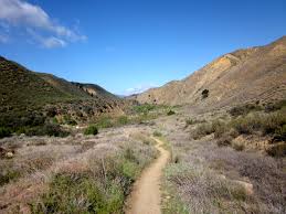
The Sespe Wilderness is a 219,700-acre (88,900 ha) wilderness area in the eastern Topatopa Mountains and southern Sierra Pelona Mountains, within the Los Padres National Forest (LPNF), in Ventura County, Southern California. The wilderness area is predominately located within in the Ojai Ranger District and Mt. Pinos Ranger District of the LPNF. The wilderness area was established in 1992 by the Los Padres Condor Range and River Protection Act. The Sespe Condor Sanctuary is within the Sespe Wilderness. It was established to promote the propagation and growth of the California Condor, and is closed to the public.

The Wilderness is predominately located in the Ojai and the Mt. Pinos Ranger Districts. One popular destination is the Willett Hot Springs. The Sespe Wilderness is mainly a chaparral covered environment with rock cliffs in various sites. There is a beautiful area called Piedra Blanca, just off highway 33 along the Piedra Blanca-Gene Marshall Trail. The Sespe Condor Sanctuary is also in the wilderness. This site, closed to the public, was established to promote the propagation and growth of the California Condor.

(20) Trails are currently available in the Sespe Wilderness ×
Agua Blanca Trail - 12.44 Miles
19W10 • Sespe • Ojai Ranger District • Ventura County
In the 1930's the U. S. Forest Service, using C.C.C. (Civilian Conservation Corps) labor, improved an old chumash trail that followed Agua Blanca Creek up the canyon. It was a popular trail because of the good hunting and fishing in the canyon. The trail begins at Festers Camp at the junction of the…
Alder Creek Trail - 5.95 Miles
20W11 • Sespe • Ojai Ranger District • Ventura County
Take Highway 126 to Fillmore. Turn north on A Street/Goodenough Road and drive 14.1 miles to Dough Flat. This is a rough dirt road that is traveled by large oil trucks. Continue on to the end of the road at the Dough Flat trailhead. Sometimes the gate is locked and you have to walk an extra 5 miles…
Buck Creek Trail - 11.10 Miles
18W01 • Sespe • Mt. Pinos Ranger District • Ventura County
This trail begins at the old Hardluck Campground on Buck Creek Road and follows Piru Creek before eventually ascending to the ridge between Sewart Mountain and McDonald Peak. Though it is still possible to connect the two trailheads, most hikers don't…
Bucksnort Trail - 2.99 Miles
19W18 • Sespe • Ojai Ranger District • Ventura County
The Sespe Wilderness - Hiking and Backpacking Trails is a beautiful 0.1 mile trail in the Non Wilderness Area Wilderness in . The trail connects the Agua Blanca Trail (19W10) and the Alder Creek Trail (20W11). Please let us know if you have explored this trail recently. Protecting…
Cedar Creek Trail - 5.80 Miles
21W10 • Sespe • Ojai Ranger District , Mt. Pinos Ranger District • Ventura County
A beautiful trail located in the Sespe Wilderness, the trailhead is located on Thorn Medow Road (7N03B) a short side road off Mutah OHV Road (7N03.2). The Cedar Creek Trail connects Thorn Medow Road (7N03B) and the GeneMarshall-Piedra…
Fishbowls Trail - 7.79 Miles
21W05 • Sespe • Mt. Pinos Ranger District • Ventura County
The Sespe Wilderness - Hiking and Backpacking Trails is a scenic 0.1 mile trail in the Non Wilderness Area Wilderness in County. The trailhead is located off Grade Valley Road (Mutah OHV Road (7N03.2)) at , . The trail connects the Grade Valley…
Johnston Ridge Trail - 9.30 Miles
20W12 • Sespe • Ojai Ranger District • Ventura County
The trailhead is near Mutau Flat, located in the Mt. Pinos Ranger District. After a rolling three miles, the trail drops steeply into Hot Springs Canyon. There is no water and little shade along the first seven miles of the trail. After 8.5 mile from the trailhead, a side trail leads into Hot Springs…
Last Chance Trail - 7.57 Miles
21W09 • Sespe • Ojai Ranger District • Ventura County
A beautiful trail in the Sespe Wilderness that connects the Santa Paula Canyon Trail (21W11) and the Red Reef Trail (21W08). At Cross Camp are several large waterfalls and deep pools that provide excellent swimming spots in the bottom…
Lion Canyon Trail - 5.62 Miles
22W06 • Sespe • Ojai Ranger District • Ventura County
Drive 14.8 miles north of Ojai on Highway 33. The trail starts at the back of Middle Lion Campground in the Rose Valley Recreation Area where it immediately crosses the stream. You will reach two trail junctions along the way. After 1.3 miles you will reach the Rose-Lion Connector Trail (22W16) on…
Little Mutau Trail - 6.29 Miles
20W10 • Sespe • Mt. Pinos Ranger District • Ventura County
The Sespe Wilderness - Hiking and Backpacking Trails is a remote 0.1 mile trail in the Non Wilderness Area Wilderness in . The trail connects the Johnston Ridge Trail (20W12) and the Alamo Mountain Road (8N01.3). Little Mutau Creek flows westward from Alamo Mountain…
Middle Sespe Trail - 7.38 Miles
22W04 • Sespe • Ojai Ranger District • Ventura County
Drive to Middle Sespe Trailhead, 17.1 miles north of Ojai on Highway 33. The trailhead is on the right side of the highway Ventura County . The trail crosses Sespe Creek and follows the old road. It then leaves the drainage and climbs over a steep bluff. Once you have reached the high point, you will drop down and…
Piedra Blanca Trail - 16.32 Miles
22W03 • Sespe • Ojai Ranger District , Mt. Pinos Ranger District • Ventura County
The Gene Marshall-Piedra Blanca Trail is a National Recreation Trail, The trail can be accessed from four locations: The Piedra Blanca Trailhead at the end of Rose Valley Road, Reyes Creek Campground, Cedar Creek Trail / Fishbowls Trail…
Pothole Trail - 5.31 Miles
18W04 • Sespe • Ojai Ranger District • Ventura County
From Highway 126, turn north on Piru Canyon Road. Drive 6 miles to the Lake Piru gatehouse and inform staff that you are parking at the Pothole Trailhead. Drive approximately 5 miles on Piru Canyon Road to the trailhead parking lot. The trail switchbacks up the ridgeline for 2.7 miles, enters the…
Potrero John Trail - 1.63 Miles
23W06 • Sespe • Ojai Ranger District • Ventura County
Take Highway 33 north of Ojai to the trailhead at mile marker 32.10. The trail is on the right hand side of the highway.  This trail provides a beautiful day hike following a stream channel into the Sespe Wilderness. It has running water most of the year. The trail ends at Potrero John Camp, but it…
Raspberry Trail - 0.57 Miles
23W42 • Sespe • Mt. Pinos Ranger District • Ventura County
Wild raspberries grow near the spring on the north face of Pine Mountain which gave this area its name. The campground is located about 1 1/2 mile down a steep trail starting at the west end of Reyes Campground. Water is available from the spring.
Red Reef Trail - 13.24 Miles
21W08 • Sespe • Ojai Ranger District • Ventura County
Park along north side of Highway 150 adjacent to Summit School. Hike one mile up Sisar Road to locked gate. Respect private property. Hike another 2.1 miles  until the Red Reef Trail leaves the road at a switchback. (If you stay on the road, you will reach Nordhoff Ridge after 4.5 miles). Follow…
Reyes Peak Trail - 5.61 Miles
23W04 • Sespe • Ojai Ranger District • Ventura County
Take Highway 33 north of Ojai to Pine Mountain Summit Road (6N06) at highway mile marker 42.50.  Turn right on the road and drive through Reyes Peak Campground.  Continue an additional mile to a parking area at the end of Reyes Peak Road. Hike about 100 yards past the barrier on the old roadbed. An…
Sespe River Trail - 18.73 Miles
20W13 • Sespe • Ojai Ranger District • Ventura County
From Highway 33, travel east on Rose Valley Road to Piedra Blanca Trailhead. Starting from the parking lot at Piedra Blanca, the trail quickly drop down to the river crossing, after the crossing Lion Creek and Sespe Creek is the Gene Marshall Piedra Blanca trail junction. The…
Stonehouse Trail - 3.97 Miles
20W35 • Sespe • Mt. Pinos Ranger District • Ventura County
The Sespe Wilderness - Hiking and Backpacking Trails is a creek side 0.1 mile trail in the Non Wilderness Area Wilderness in . The trail connects the Johnston Ridge Trail (20W12) to the Piru OHV Trail (20W07). Please let us know if you have explored this trail recently.    
Thorn Point Trail - 3.46 Miles
21W07 • Sespe • Ojai Ranger District , Mt. Pinos Ranger District • Ventura County
Thorn Point is located in the Sespe Wilderness, within the Los Padres National Forest.  About 20 miles southwest of Frazier Park, 90 miles from Los Angeles. This peak has a Lookout tower is very weathered has seen better days, but the tower…