Welcome To Hike Los Padres!
User Log In or Sign Up

San Rafael Wilderness - Hiking and Backpacking Trails

Backpacking and Hiking Trails in the San Rafael Wilderness, Los Padres National Forest


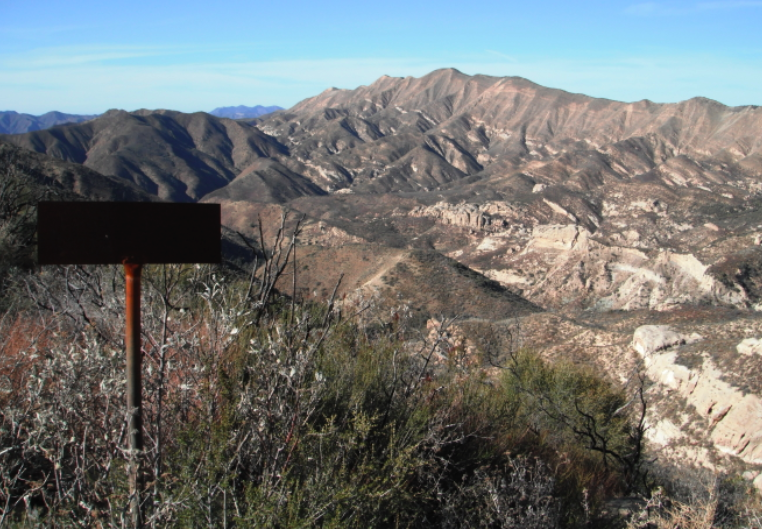
Most of the wilderness lies between the crests of two parallel mountain ranges, the San Rafael Mountains and Sierra Madre Mountains, and includes the drainages of two watercourses: the Sisquoc River and Manzana Creek. Both flow to the northwest, eventually joining together and draining into the ocean near Santa Maria. Elevations within the wilderness vary from 1,166 feet (355 m) at the confluence of Manzana Creek and the Sisquoc River on the western boundary, to over 6,800 feet (2,100 m) at Big Pine Mountain, the highest point in Santa Barbara County. Dividing the drainages of the Manzana and Sisquoc is a ridge known as Hurricane Deck, a rugged 15-mile (24 km) slab of upthrust sandstone with a trail snaking along the top.

Rock formations in the wilderness are predominantly sedimentary, and are of Miocene and Cretaceous age. Both the Nacimiento and Big Pine Faults run through the wilderness, roughly parallelling the Sierra Madre and San Rafael Mountain crests respectively. Hurricane Deck is a single block of Miocene-age sedimentary rock. Immediately south of the wilderness, opposite the Big Pine and Camuesa Faults, is a large region of the Franciscan Formation. Mercury was formerly mined in this area, and abandoned mines along with tailings piles can be found.

(17) Trails are currently available in the San Rafael Wilderness ×
Big Cone Spruce Trail - 3.20 Miles
28W04 • San Rafael • Santa Lucia Ranger District • Santa Barbara County
The San Rafael Wilderness - Hiking and Backpacking Trails is a short 0.1 connector mile trail in the Non Wilderness Area Wilderness in . The trail starts from Cachuma Mountain Road at , and connects with the Manzana Trail (30W13) just passed Manzana…
Grapevine Trail - 5.39 Miles
27W10 • San Rafael • Santa Barbara Ranger District • Santa Barbara County
The Grapevine Trail is located in the southern San Rafael Wilderness and connects the Santa Cruz Trail to the Buckhorn Road at Bluff Cabin.  There are a few stories as to how the Grapevine Trail got its name.  One legend states that it was named after a grapevine plant which once grew at the Murietta…
Horse Canyon Labrea Trail - 23.1 Miles
31W09 • San Rafael • Santa Lucia Ranger District • Santa Barbara County
The San Rafael Wilderness - Hiking and Backpacking Trails is a scenic 0.1 mile trail in the Non Wilderness Area Wilderness in County.  The trail connects the La Brea Canyon. OHV Raod (10N06.1) and the 3 trails junction at the Manzana Schoolhouse. The three trails are the…
Hurricane Deck Trail - 13.91 Miles
30W14 • San Rafael • Santa Lucia Ranger District • Santa Barbara County
The Hurricane Deck Trail was constructed in the 1930's. The trail starts near the Manzana Schoolhouse on the Sisquoc Trail (30W12) and after climbing to the crest of the Hurricane Deck, the trail follows along the crest of the deck until it ends at White Ledge…
Jackson Trail - 4.45 Miles
27W05 • San Rafael • Santa Lucia Ranger District • Santa Barbara County
It was named after Mr. Jackson who ran cattle in the late 1890's on the Potreros on the crest of the Sierra Madre Mountains. The Jackson Spring is near the top of the climb the trail makes from Ed Montgomery's homestead on the Sisquoc River up to Montgomery Potrero where Josiah…
Judell Trail - 4.90 Miles
26W05 • San Rafael • Santa Lucia Ranger District • Santa Barbara County
The Judell Trail descends from Santa Barbara Potrero into the San Rafael Wilderness to its terminus at the junction with the Sisquoc Trail.  The trail has seen quite a bit of LPFA and VWR attention after the 2007 Zaca Fire but sees little traffic.  As a result you should expect the trail to be very…
Lost Valley Trail San Rafael Wilderness - 7.12 Miles
29W14 • San Rafael • Santa Lucia Ranger District • Santa Barbara County
The Lost Valley Trail connects Manzana Creek with the Hurricane Deck Trail.  The trail is used by day hikers looking to explore the secrets of Lost Valley as well as a connection for backpackers heading towards the Sisquoc. In the early 20th century there were plans to build a road…
Manzana Trail East (Upper) - 13.8 Miles
30W13 • San Rafael • Santa Lucia Ranger District • Santa Barbara County
The East Trail (31W13.2) follows the Mazana canyon east to the narrows, then climbs over the Hurricane Deck at White Ledge to end at South Fork Guard Station on the Sisquoc River. Access the trial from Nira Campground via Sunset Valley Road. MANZANA - A Spanish word for little apples. In the…
Manzana Trail West (Lower) - 8.7 Miles
30W13.2 • San Rafael • Santa Lucia Ranger District • Santa Barbara County
The west portion of the Manzana Trail in the San Rafael Wilderness spans from the Manzana Schoolhouse to Nira Campground. The Lower Manzana Trail intersects with the Sisquoc Trail and reaches the Sisquoc River near the Schoolhouse. Access the trial from Nira Campground via Sunset…
Mission Pine Trail - 14.55 Miles
28W01 • San Rafael • Santa Lucia Ranger District , Santa Barbara Ranger District • Santa Barbara County
The Mission Pine Trail connects Cachuma Mountain Forest Road (8N08.2) and Buckhorn Forest Road (9N11.4). The trail is in the San Rafael Wilderness, So remember no mountain biking is allowed on any wilderness trails.
Potrero Canyon Trail - 2.90 Miles
29W12 • San Rafael • Santa Lucia Ranger District • Santa Barbara County
The trail is located one mile down from the Lower Manzana Trailhead (aka Lower NIRA) along Manzana Creek.  The trailhead for Potrero Trail is between the two trail camps at Potrero Camp.  It begins at the junction of Manzana Creek Trail 30WI3 and Potrero Canyon Trail 29W12. The trail climbs consistently,…
Roque Canyon Trail - 5.68 Miles
30W03 • San Rafael • Santa Lucia Ranger District • Santa Barbara County
The San Rafael Wilderness - Hiking and Backpacking Trails is a scenic 0.1 mile trail in the Non Wilderness Area Wilderness in . The trail connects the Sierra Madre Ridge Road and the Kerry Canyon OHV Trail (30W02). Please let us know if you have explored this trail recently.…
Santa Cruz Trail - 18.47 Miles
27W09 • San Rafael • Santa Barbara Ranger District • Santa Barbara County
WARNING: THERE IS A SKETCHY SLIDE LOCATED ABOUT 4 MILES UP THE TRAIL FROM UPPER OSO ALONG THE SOUTH SLOPE OF LITTLE PINE MOUNTAIN THAT IS NOT PASSABLE FOR SOME…
Sisquoc Trail Lower - 20.4 Miles
30W12 • San Rafael • Santa Lucia Ranger District • Santa Barbara County
The Upper Sisquoc Trail is located in the San Rafael Winderness and extends from South Fork Camp to Alamar Saddle and Manzana Schoolhouse Camp. This trail follows back and forth across the Sisquoc River from the junction with Horse Gulch, below…
Sisquoc Trail Upper - 11.06 Miles
30W12 • San Rafael • Santa Lucia Ranger District • Santa Barbara County
The Upper Sisquoc Trail is located in the San Rafael Winderness and extends from South Fork Camp to Alamar Saddle and Alamar Saddle Camp. This trail follows back and forth across the Sisquoc River from the junction with Horse Gulch, below the…
Sweetwater Trail - 6.76 Miles
27W06 • San Rafael • Santa Lucia Ranger District • Santa Barbara County
The San Rafael Wilderness - Hiking and Backpacking Trails is a 0.1 mile trail in the Non Wilderness Area Wilderness in . The trail connects the Sierra Madre Road to the Sisquoc Trail (30W12). Sweetwater Canyon was so named because the creek water does not contain alkali…
White Elephant Trail - 2.51 Miles
30W29 • San Rafael • Santa Lucia Ranger District • Santa Barbara County