 Use Marker Groups
 Wolf 2002
Piru 2003
Day 2006
Zaca 2007
Gap 2008
La Brea 2009

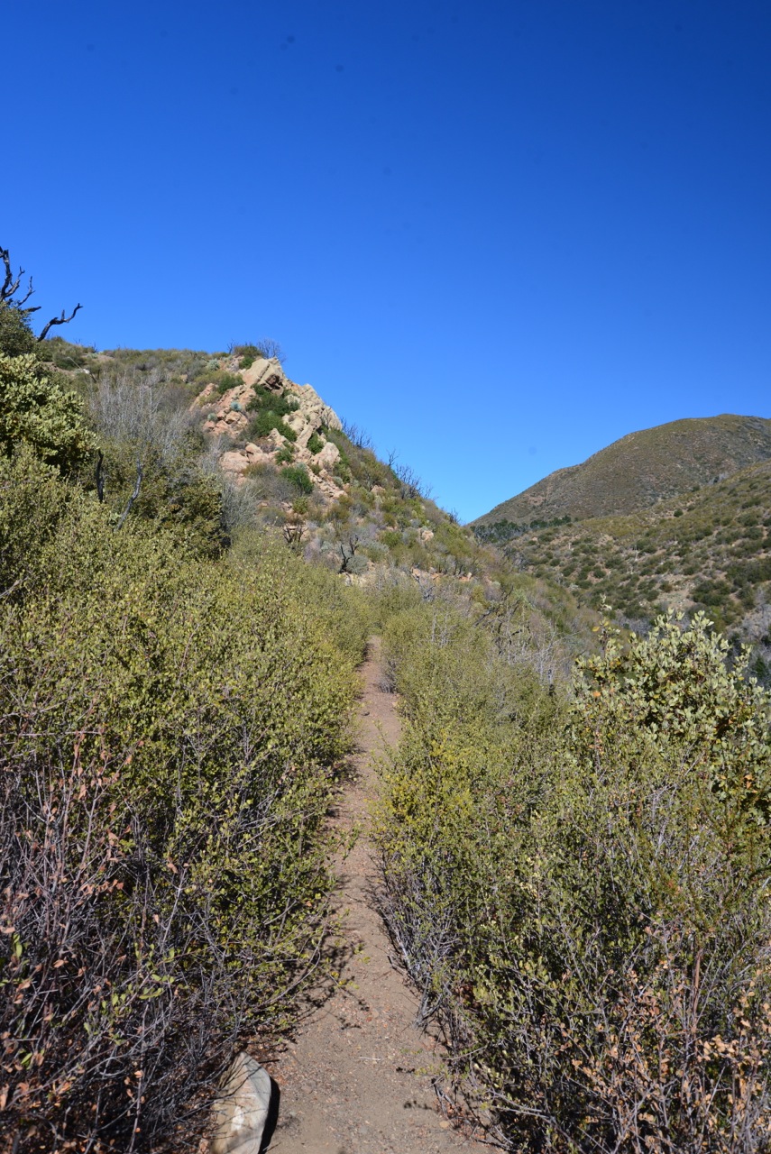
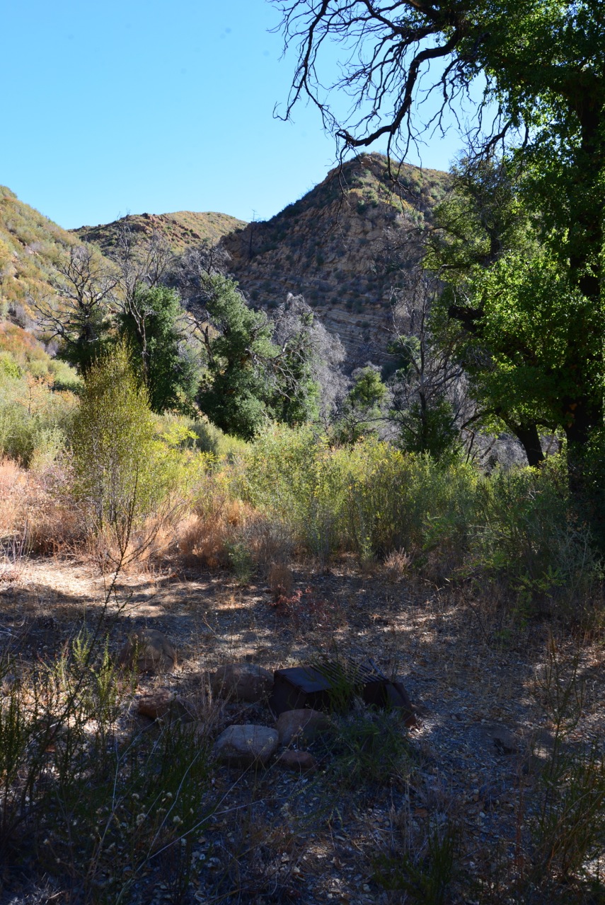
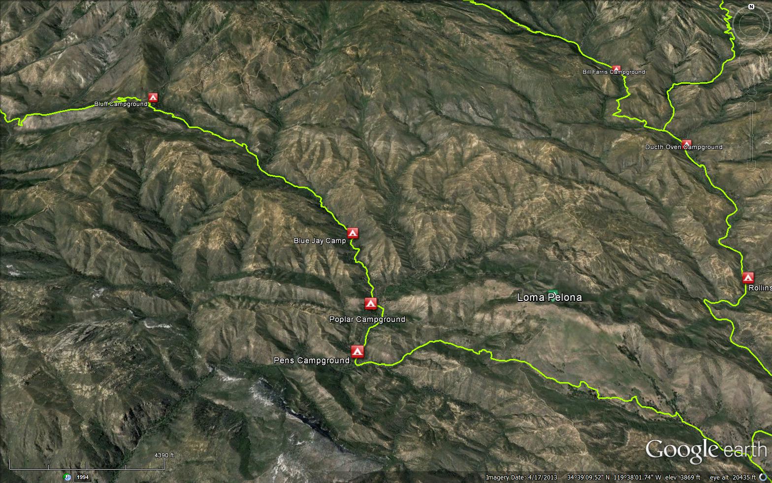
The Poplar Trail is a senic 6.50 mile trail in the Dick Smith Wilderness in Santa Barbara County County. The trail follows the Indian Creek and connects the Mono-Alamar Trail (26W07) and the Bluff Guard Station (4,480 feet). Please let us know if you have explored this trail recently. Starting on the south face of Big Pine Mountain at a spring a short distance above Bluff Camp, the creek descends to Pens Camp where it bends to the west for a mile then cuts through the Sierra Blanca Limestone and then down through a narrow of sandstone formation to finally open up and join Mono Creek a short distance before this creek enters the Santa Ynez River. A trail follows along the creek except in the narrows where the stream bed must be walked. There are several deep pools and beautiful waterfalls.


 Poplar Trail Survey - 02-13-2026 - by Amelie Grant
| Link: | Poplar Trail |
| Date: | 02-13-2026 |
| Surveyor Name: | Amelie Grant |
| Trail description: | we hiked from pens to loma pelona and then down to the mono-alamar trail... Gorgeous area but trail is totally overgrown. tread is followable and we left it VERY well taped, but prepare to crawl through the chaparral. I was in a school group and it took the 11 of us ~3 hours to go the 1 mile from pens to loma. |
| Mode of transport: | Hike |
| Trail condition: | Hard to follow |
| Condition details: | prepare to crawl! well taped and tread is followable, but chaparral is brutal |
Poplar Trail Survey - 03-27-2025 - by Chris Berry | Link: | Poplar Trail |
| Date: | 03-27-2025 |
| Surveyor Name: | Chris Berry |
| Trail description: | We only did the 1 mile section of this trail down from the Loma-Victor fire road to Pens camp and the trail was next to non-existent. Multiple sections of hands and knees crawling, hoping to find the occasional cut stumps of chaparral to indicate there once was a trail here. A few decaying pieces of orange flagging helped give hints that we were on the correct path. Overall, very hard to follow and it took close to 3 hours to get through. Had we been going uphill I don't know that we would have succeeded. Unsure of the status of the trail up to Bluff as we exited down Indian Creek. Lot's of water flowing in Indian Creek at Pens. Pens camp was fairly overgrown but there was enough space to pitch a couple of tents. |
| Mode of transport: | Hike |
| Trail condition: | Non existent |
| Images: | Sign at entrance to Dick Smith at Loma-Victor Fire road Looking West into Indian Creek drainage from Loma-Victor fire road |
Poplar Trail Survey - 04-27-2022 - by Ojai Valley School Lower Campus| Link: | Poplar Trail |
| Date: | 04-27-2022 |
| Surveyor Name: | Ojai Valley School Lower Campus |
| Trail description: | The route from Loma Pelona down into Pens is almost entirely GONE. When you drop off the road heading west the trail descends through grass, and enters chaparral. It switchbacks steeply for a bit and then levels off and runs almost straight west toward Pens. At the point that the switchbacks end, we began flagging with red and orange, following black/orange polka dot flags as well. There is no sign of previous tread, and there is no sign of previous cuts/pruning or ducks. The brush was intense and we tunneled, crawled, and generally got thrashed the rest of the way to camp. This section is about 1.5 miles and it took us 2+ hours. Eventually, we blew it off and walked creek bed as our clothes and skin were shredded. Tough little section that I would not recommend. |
| Mode of transport: | Hike |
| Trail condition: | Non existent |
| Condition details: | Loma Pelona to Pens |
Poplar Trail Survey - 04-01-2022 - by Addison Jerlow| Link: | Poplar Trail |
| Date: | 04-01-2022 |
| Surveyor Name: | Addison Jerlow |
| Trail description: | Trail from Loma Pelona down to Pens is rough. A few pieces of tape left but lots of deadfall and really thick ceanothus and scrub oak. Some crawling necessary. A few flags left but a lot are disintegrating. Following the old trail maintenance cuts is your best bet. |
| Mode of transport: | Hike |
| Trail condition: | Hard to follow |
Poplar Trail Survey - 02-06-2022 - by Stephen S| Link: | Poplar Trail |
| Date: | 02-06-2022 |
| Surveyor Name: | Stephen S |
| Trail description: | I hiked from Bluff town to Pens which was relatively easy the entire way and was mostly in good shape. From there I went up to Loma Pelona Victor Fire Road and this was probably the worst bushwhacking I did all weekend. There was some flagging (thank you whoever did this!), but most of the section was slowly picking my way through until the last .2 miles. |
| Mode of transport: | Hike |
| Trail condition: | Good shape and easy to follow |
Poplar Trail Survey - 04-09-2021 - by LPFA| Link: | Poplar Trail |
| Date: | 04-09-2021 |
| Surveyor Name: | LPFA |
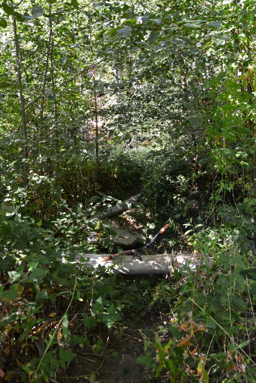
| Trail description: | Lead a trail project to brush Poplar Trail between Bluff Camp and Blue Jay Camp. Spent 6 hours brushing, clearing trees, and some basic treading. Trail is in excellent hiking condition now. Some branches still too low for equestrian work. Faucet Springs Dry (as usual). Still one downed tree that we were unable to move, and didn't have the right equipment to cut and move (see picture). Really beautiful trail with varied topography. Get out there! |
| Mode of transport: | Hike |
| Trail condition: | Good shape and easy to follow |
| Images: | |
Poplar Trail Survey - 03-05-2021 - by Luna| Link: | Poplar Trail |
| Date: | 03-05-2021 |
| Surveyor Name: | Luna |
| Trail description: | Hiked from Bluff to Pens. Plenty of water. A rock fall happened about 1/2 mile south of blue jay camp. Easily passable, but a large tree may come down soon now. Countless encroaching whitethorn ceanothus on the trail, forcing you to crouch and push through or get down on your knees and crawl. About 10 fallen dead trees, all <1ft thick but a pain to squeeze through. Many sections of poison oak ready to come into bloom and block the trail for anyone sensitive, but it has not started to bud yet. Lots of smaller rose bushes. Spring has not arrived yet, everything for the most part looks dormant and brown. |
| Mode of transport: | Hike |
| Trail condition: | Needs some work |
| Condition details: | Trail is easy to follow, but quite overgrown |
Poplar Trail Survey - 01-07-2021 - by John O'Connell| Link: | Poplar Trail |
| Date: | 01-07-2021 |
| Surveyor Name: | John O'Connell |
| Trail description: | Trail on the field on Loma Pelona was hard to follow. There were a few white posts marking the general direction but nearer to the FS road they disappeared. Over the top of the hill, the trail had been cleared for the first half mile or so and was in decent shape. After the first stream crossing, however, the trail completely disappeared and turned into intense bushwhacking for the next 3/4 mile. Thankfully the route had been flagged and was followable, albeit slowly and painfully. Once the trail hit Pens, the trail became significantly better, although it was dogged by numerous low-hanging branches that were annoying more than anything all the way to Bluff. Water was abundant in this area through the numerous streams. |
| Mode of transport: | Hike |
| Trail condition: | Hard to follow |
Poplar Trail Survey - 12-13-2020 - by MWiltshire| Link: | Poplar Trail |
| Date: | 12-13-2020 |
| Surveyor Name: | MWiltshire |
| Trail description: | Overgrown but passable from Bluff Station to Pens Camp. Very overgrown and difficult to follow from Pens Camp to Loma Pelona Victor Fire Rd |
| Mode of transport: | Hike |
| Trail condition: | Needs some work |
| Condition details: | Brushy but passable from Bluff Station to Pens Camp. |
Poplar Trail Survey - 10-28-2020 - by Los Padres Forest Association| Link: | Poplar Trail |
| Date: | 10-28-2020 |
| Surveyor Name: | Los Padres Forest Association |
| Trail description: | The Forest Service and a volunteer hiked the Poplar Trail from Bluff down to Pens and here are the two reports we got back: FOREST SERVICE The trail is good over all. There were two spots where large dead tree
limbs fell across the trail, the hassle there is they crushed the
surrounding brush onto the trail. If you have camping packs you might
have to take off and maneuver through with them. There are also a
number of spots were the brush (buckthorn) leans into the trail and you
have to decide to either go under, over, or through. The trail tread is
good but for some reason the buckthorn likes to lean a few of it’s
branches across the trail. We all got scratched up to varying degrees. VOLUNTEER WAY overgrown
on the lower half around where there is the last good running water (unnamed tributary) there were several huge trees
down, crawling under, etc. |
| Mode of transport: | Hike |
| Trail condition: | Needs some work |
Poplar Trail Survey - 10-24-2018 - by Los Padres Forest Association| Link: | Poplar Trail |
| Date: | 10-24-2018 |
| Surveyor Name: | Los Padres Forest Association |
| Trail description: | LPFA 10-day Working Vacation based at Bluff Cabin and focused on working down the Poplar Trail. We were able to complete work up to 0.5 miles above Poplar Camp. |
| Mode of transport: | Hike |
| Trail condition: | Needs some work |
| Images: | |
Poplar Trail Survey - 02-25-2019 - by Los Padres Forest Association| Link: | Poplar Trail |
| Date: | 02-25-2019 |
| Surveyor Name: | Los Padres Forest Association |
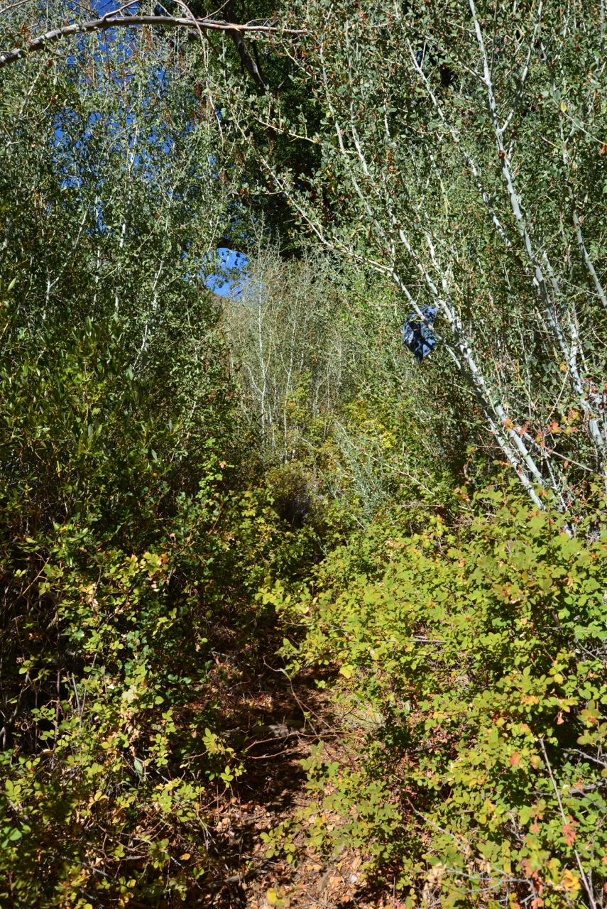
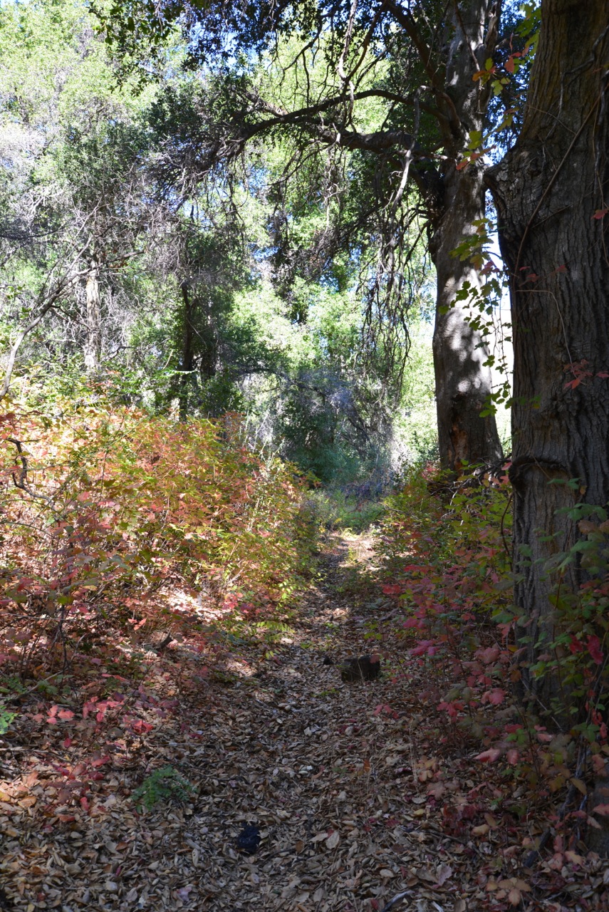
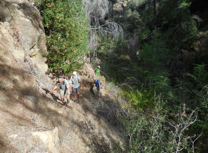
| Trail description: | LPFA Trail Survey of the entire Poplar Trail starting from the junction of Poplar, Mono-Alamar and Alamar and finishing at Bluff Camp. - The trail starting at Mono-Alamar / Alamar Trails is pretty good up to the bottom of the Lomas. Follow flagging where needed and tread should guide you up the correct spine and up onto the lower Lomas. - Once on the Lomas we've installed a series of white PVC pipe positioned over t-posts to help guide you up the Lomas. There is no trail, just go from point to point following the pipes line of sight. The upper part of the trail as it connects with the Don Victor Jeepway is hard to follow through a thick yucca garden but very pretty. When in doubt, go up. - Once you cross the old road you enter the Dick Smith and the trail is okay for a while until you hit the lower drainages and then it pretty much disappears. Lots of people get lost in here. There are flags laid out but you'll be crawling and pushing your way through the ceonothus until you spill out onto Indian Creek and Pens. - From Pens the trail is rough for about 6/10 of a mile before connecting in with work that the LPFA volunteers completed in October 208. From there up to Bluff is in great shape other than some severe rutting on the upper reaches. |
| Mode of transport: | Hike |
| Trail condition: | Needs some work |
| Condition details: | Trail varies from GREAT to HORRID |
| Images: | Junction of Poplar, Mono-Alamar and Alamar Trails. Poplar heads up-canyon towards the distinct Loma Pelona Once on the Lomas, follow the PVC pipes. The bear have bent and knocked a few over. This is the bad section between Lomas and Pens, in particular the lower portions. Not much trail to follow. Iconic Indian Creek, so nice! Upper section of Poplar showing the extended ruts |
Poplar Trail Survey - 06-28-2019 - by Los Padres Forest Association| Link: | Poplar Trail |
| Date: | 06-28-2019 |
| Surveyor Name: | Los Padres Forest Association |
| Trail description: | The LPFA Trail Crew spent a few days cleaning up water drainage features along the Poplar Trail, in particular the very rutted sections between Bluff and the first creek crossing. As of summer 2019 the Poplar Trail is a wilderness freeway from Bluff down to Pens Camp, beyond that heading up towards the Lomas it is one of the worse trails you'll encounter. Very overgrown, downed trees, hard to follow and expect to get lost with extreme bushwhacking. |
| Mode of transport: | Hike |
| Trail condition: | Good shape and easy to follow |
| Images: | Poplar Trailhead at Bluff Water Control Feature Water Control Feature Water Control Feature |
Poplar Trail Survey - 04-29-2018 - by Los Padres Forest Association| Link: | Poplar Trail |
| Date: | 04-29-2018 |
| Surveyor Name: | Los Padres Forest Association |
| Trail description: | This trail may be the most overgrown 'regularly used' trail in the Southern Los Padres at the moment. It's covered with downed trees, 8ft high brush and walls of poison oak. It is mostly followable but expect to push, wade, crawl, scramble and dive your way across and over the obstacles...... LPFA is planning a Working Vacation in October 2018 to fix the trail. Stay tuned! |
| Mode of transport: | Hike |
| Trail condition: | Hard to follow |
| Condition details: | Trail is a mess! |
| Images: | Photo Humphrey Photo Humphrey Photo Humphrey |
Poplar Trail Survey - 05-29-2016 - by Los Padres Forest Association| Link: | Poplar Trail |
| Date: | 05-29-2016 |
| Surveyor Name: | Los Padres Forest Association |
| Trail description: | LPFA trail projects working the Poplar Trail from Pens Camp up and over to the Mono-Alamar Trail junction. Â The trail is now very passable and clear but more brushing is needed, mostly on the Indian Creek side. Â We led two projects along the trail. Â The first in April and the second in late May. Â More photos at the LPFA Facebook page below: https://www.facebook.com/LosPadresForestAssociation/posts/618307491627512?notif_t=like¬if_id=1481309113196993 |
| Mode of transport: | Array |
| Trail condition: | Needs some work |
Poplar Trail Survey - 02-28-2016 - by Los Padres Forest Association| Link: | Poplar Trail |
| Date: | 02-28-2016 |
| Surveyor Name: | Los Padres Forest Association |
| Trail description: | THIS IS THE PORTION OF THE POPLAR TRAIL THAT CONNECTS INDIAN CREEK WITH THE MONO-ALAMAR TRAIL This trail is sometimes referred to as the Alamar Hill Trail, most of the old signage shows it as Alamar Hill Trail. Â The trail leading from Pens up towards the Lomas is hard to follow, if not completely gone. Â There are some flags but the recent washouts have filled the creeks in with enough silt to make traveling through the creekbed easier than trying to follow the "trail". Â Be careful as the trail heads up the northern creekbeds and not the larger ones. Â I suggest bringing a GPS or detailed topo map. Â People have gotten lost in here. Â Once you get out of the creek and onto the switchback section it is pretty easy to make it to the Lomas. Â You'll still get lost but not for much more than a minute or two. Once at the Lomas it is equally as hard to follow the trail down towards Alamar Hill. Â There are metal posts set across the canyon that you can follow. Â Be sure to head as far to the left (north east) as you can as you head down the Lomas. Â The trail is near the "spring" at the far north east side. Â If you can follow the metal posts then you are going the right way. Don't expect to find any water between Indian Creek and at least Alamar Creek or Mono Narrows and during summer months there may be no water out here at all. |
| Mode of transport: | Hike |
| Trail condition: | Hard to follow |
| Images: | The washout creek section between Pens and the Lomas Looking down from the Lomas into Indian Creek and towards Pens Camp Looking down the Lomas towards Mono Narrows and Alamar Hill One of the metal posts marking the way down the Lomas Junction of Poplar, Alamar and Mono-Alamar Trails |
Poplar Trail Survey - 02-28-2016 - by Los Padres Forest Association| Link: | Poplar Trail |
| Date: | 02-28-2016 |
| Surveyor Name: | Los Padres Forest Association |
| Trail description: | THIS IS THE PORTION OF THE POPLAR TRAIL BETWEEN BLUFF CAMP AND PENS CAMP |
| Mode of transport: | Hike |
| Trail condition: | Needs some work |
| Images: | Upper section near Bluff. Trail in good shape. One badly rutted section. Need to get the water flowing off the trail here. Typical post fire white thorn ceonothus tunnel. Upper Indian Creek showing off her stuff. Between Poplar and Pens you get great views. |
Poplar Trail Survey - 02-28-2016 - by Anonymous Surveyor| Link: | Poplar Trail |
| Date: | 02-28-2016 |
| Surveyor Name: | Anonymous Surveyor |
| Trail description: | Beginning around Blue Jay camp the trail deteriorates significantly. Â Lots of encroaching brush, and numerous tree falls (some of which are impassible to stock users). Â PO is just starting to bud out making it sometimes difficult to see/avoid. Tricky sections, at creek crossings in particular, are flagged. Â Not too hard to stay on the trail... just slow going picking your way through snags, thorns and brush. Plenty of running water in the creek the entire way. |
| Mode of transport: | Hike |
| Trail condition: | Needs some work |
Poplar Trail Survey - 11-14-2015 - by Los Padres Forest Association| Link: | Poplar Trail |
| Date: | 11-14-2015 |
| Surveyor Name: | Los Padres Forest Association |
| Trail description: | Trail is in poor shape after about a mile from Bluff. Brush reaches across trail in many places. Also lots of downed branches and trees – we had to break a way through for hikers, not passable for equestrians. No indication Blue Jay, Poplar or Pens have been used recently. Indian Creek dry except flowing for a stretch above Blue Jay |
| Mode of transport: | Array |
| Trail condition: | Needs some work |
Poplar Trail Survey - 09-27-2015 - by Los Padres Forest Association| Link: | Poplar Trail |
| Date: | 09-27-2015 |
| Surveyor Name: | Los Padres Forest Association |
| Trail description: | LPFA VWR patrol from Bluff down to Indian Narrows. Â No water along entire stretch of trail but there was some water at the Narrows. Â Trail is hard to follow in places and we got off the trail a few times going in each direction. Â Work is certainly needed. Â The rose is thick at the moment as well. |
| Mode of transport: | Array |
| Trail condition: | Hard to follow |
| Images: | Photo Curt Cragg |
Poplar Trail Survey - 03-21-2015 - by Anonymous Surveyor| Link: | Poplar Trail |
| Date: | 03-21-2015 |
| Surveyor Name: | Anonymous Surveyor |
| Trail description: | Day hiked from Bluff down to Pens and beyond. Steady flow of water the whole way in Indian Creek. Â Faucet Spring, however, was dry. From Bluff, the trail starts easy to follow up until about Blue Jay camp. Â There's a couple of sections of trail on the way to Blue Jay that look like they may be lost soon to a slide or rutting, but otherwise, it's mostly clear, easy walking. Beginning around Blue Jay, the trail becomes much narrower and more overgrown. Â Lots of small tree falls and encroaching brush. Â Tread becomes faint and at times a little tough to follow, especially in/around creek crossings. Â The Poison Oak gets bad between Blue Jay and Poplar, then lets up a bit on the way to Pens. No evidence of any recent visitors to Blue Jay or Poplar, but Pens had some semi-fresh trash in the fire ring. Strangely, the trail was much more difficult to find/follow on the way back up toward Bluff from Pens than it was on the way down. Â On multiple occasions during our return trip we lost the trail between Pens and Poplar. All in all, the trail is pretty faint and rough. Â Of course, this is par for the course in these parts and is part of the reason this area is a reliable destination for some solitude. |
| Mode of transport: | Hike |
| Trail condition: | Hard to follow |
| Condition details: | Overgrown; doesn't see much use |
Poplar Trail Survey - 10-02-2014 - by Los Padres Forest Association| Link: | Poplar Trail |
| Date: | 10-02-2014 |
| Surveyor Name: | Los Padres Forest Association |
| Trail description: | Â It need lots of brushing, trees down. Â Only a couple remote spots with h20 flowing down in the valley about 1.5 miles down from Bluff. Â It would be good to brush to Pens, then brush up to the Lomas. Â I added some flags to help get people down to Pens from Bluff. |
| Mode of transport: | Hike |
| Trail condition: | Needs some work |
| Images: | Photo Humphrey Photo Humphrey Photo Humphrey Photo Humphrey Photo Humphrey |
 Survey / Report Form - Please click this box to open the form.