 Use Marker Groups
 Wolf 2002
Piru 2003
Day 2006
Zaca 2007
Gap 2008
La Brea 2009

From Highway 33, travel east on Rose Valley Road to Piedra Blanca Trailhead. Starting from the parking lot at Piedra Blanca, the trail quickly drop down to the river crossing, after the crossing Lion Creek and Sespe Creek is the Gene Marshall Piedra Blanca trail junction. The Sespe River Trial proceeds down stream and is in excellent shape. At one point the trail was a forest service road that lead to Willets Hot Spring, after the wilderness protection act the road was closed to car traffic and only open for hiking and horseback riding.
Continue hiking 4.3 miles from the trial head to the first camp along the trail named Bear Creek Camp (2820 feet). This is a wonderful camp located on a large sandbar with a swimming and shade from cottonwood trees. Past the camp you will come to Kerr Spring, the first year-round water source, which is located .8 miles further from Bear Creek Camp on the south side of the river. Continuing towards Hot Springs Canyon, there are several more camps before you reach Willets. First is Oak Flat Camp (2600 feet) (7.4 miles from trailhead). After Oak Flat Camp the trail has another junction with the Red Reef Trail (21W08). Another 9.4 miles down the trail is Thacher Camp (2528 feet) which is sort of an overflow camp for Willet Camp and Hot Spring (2520 feet) (9.8 miles), as you continue on you will find Hartman Camp (2489 feet) (10.9 miles), and then Coltrell Flat Camp (2312 feet) (14 miles). Just after Coltrell Flat the third trail juntion is with the Johnston Ridge Trail (20W12). The Johnston Ridge Trail leads to Mutau Flat and the Matau Trail. Past the junction you will find Shady Camp (2440 feet) at 17.5 miles. The trail then quickly ends near Alder Creek Camp (2520 feet) and turns into the Alder Creek Trail.
The entire length of the Sespe River Trail has ten crossings of the Sespe River. Use caution when travelling during the wet season due to the potential of flash flooding. Since this trail is in the wilderness, only hikers and equestrians are permitted. The river is considered one of the best trout fishing streams in Ventura County. It used to have an annual Steethead Trout run but dam construction and drought years have ended these runs.
Sespe Creek is a stream, some 61 miles long in Ventura County. The creek starts at Potrero Seco in the eastern Sierra Madre Mountains, and is formed by more than thirty tributary streams of the Sierra Madre and Topatopa Mountains, before it empties into the Santa Clara River in Fillmore. Thirty-one miles (50 km) of Sespe Creek is designated as a National Wild and Scenic River and National Scenic Waterway, and is untouched by dams or concrete channels. It is one of the last wild rivers in Southern California. It is primarily within the southern Los Padres National Forest.
The name Sespe can be traced to a Chumash Indian village, called Cepsey, Sek-pe or S'eqpe' ("Kneecap") in the Chumash language in 1791. The village appeared in a Mexican Alta California land grant called Rancho Sespe or Rancho San Cayetano in 1833
The creek remains free from major habitat modifications and is noteworty for its lack of dams, although one was originally proposed for a site named Topa Topa near Sespe Hot Springs in the Sespe Wilderness. After originating above 5,000 feet (1,500 m) in the Sierra Madre Mountains in the northwest corner of the Ojai Ranger District, about 75 percent of the Sespe Creek subwatershed is characterized by numerous rugged slopes and canyon walls of the southern Pine Mountains. It flows intermittently but is characterized by a series of permanent deep pools. Major tributaries include the Lion Canyon, Hot Springs Canyon, Timber, West Fork Sespe and Little Sespe Creeks, although over 30 creeks and springs nourish it. Sespe Creek receives most of its rainfall between January and April, and furnishes 40% of the water flowing in the Santa Clara River.
Also known as Arroyo Sespe, Cespai River, Sespe River.
To learn more about gear visit the following:
.jpg)


 Sespe River Trail Survey - 05-25-2025 - by AidLenSel
| Link: | Sespe River Trail |
| Date: | 05-25-2025 |
| Surveyor Name: | AidLenSel |
| Trail description: | Trail is in great shape and easy to follow after the first few river crossings. Just keep an eye out for markers and such. The crossing at Bear Creek Camp was a bit tough to find, but some nearby campers were helpful enough to guide us. Get out there before the water dries up! There are still a few swimmable pools, but it has been a dry winter so I wouldn’t wait. Also, watch out for poison oak by Kerr spring, there’s a whole lot, sometimes coming into the trail. |
| Mode of transport: | Hike |
| Trail condition: | Good shape and easy to follow |
| Images: | |
Sespe River Trail Survey - 04-25-2025 - by Zachary Caipang| Link: | Sespe River Trail |
| Date: | 04-25-2025 |
| Surveyor Name: | Zachary Caipang |
| Trail description: | We started the hike from the Piedra Blanca trailhead towards the Sespe Hot Springs on the morning of 4/25/25. The weather was overcast and cloudy, making for great hiking conditions. The first 10 miles of the trail to Willett Camp are well maintained with little overgrowth. As the trail follows the Sespe River, the general profile of the trail is flat, allowing for quick and relaxed hiking.The first day of the trip to Willett took us through two other camps: Bear Creek at mile 4 and Oak Flat at mile 7. Both camps had ample water, with water deep enough for swimming. All the river crossings we encountered on the first day were passable with manageable maneuvers by stepping across rocks; water depth averaged about 1 foot at the crossings. Compared to last year, the general water level of the Sespe is significantly lower; however, for a low storm year, the water levels were still decent. After Oak Flat, the trail took us through various plateaus with meadows of tall grass with views of the towering Topa Topa Bluff and the Red Reef rocks to the south. Just past the junction with the Red Reef trail, we began our descent to our first camp at Willett Hot Springs. Here, the trail can be easily lost. Most of the camp sites are on the northern side of the river, so it’s best to stick to the left of the Sespe before deciding on a spot to set up camp. The Willett Camp is large with plenty of campgrounds spread out around the area with amenities (tables, fire pits, vault toilet). The Willett hot spring is up a steep hillside climb north of the camp. The temperature of the tank at the hot spring felt around 100 degrees. The temperatures at camp that night were comfortable with what felt like high 40s to low 50s. The next day we continued our hike to the main Sespe Hot Springs, around 6 miles away from our camp at Willett. We got rained on the entire morning, making for a miserable day of hiking.The trail past Willett, especially the first 4 miles is a lot harder to follow. These 4 miles involved switching back and forth between the trail and the riverbed, as the trail follows the Sespe River closely with a plethora of river crossings.The river crossings past Willett were noticeably more frequent and higher flow than crossings we dealt with the day before; some crossings seemed to be around 2’ in depth. Due to the trail being difficult to follow, there were many trail marker rock cairns and pink ribbons to alert hikers of the correct way. The proximity to the river entailed many washed out areas of the trail, and many of the intact trails outside of the riverbed were cluttered with overgrowth and noticeable areas of poison oak. At around mile 4 the trail veers north of the river and begins to climb the mountainside. Due to the rain, we were not checking our GPS maps as frequently and we missed the trail, and we had to climb up a steeper grassy hillside to intercept the official trail. If low on water, it is best to filter water before this climb as any water sources encountered north towards the Sespe Hot Springs are warmer due to the residual water from the hot springs flow. The climb up from the Sespe River takes you to a saddle in the mountain that overlooks a small vegetated valley. At this point the rain stopped, and we could see the Topa Topas to the south covered in snow. After hiking into and out of the valley, we hit the junction with the Johnston Ridge Trail. At this junction we began hiking north on the Johnston Ridge Trail towards Sespe Hot Springs. The trail north was full of warm streams and some small areas of poison oak. After hiking north for over a mile, we made our way into a white rock canyon. Through the east side of the canyon ran the hotspring, with the stream getting hotter the further north upstream through the canyon. We ended up hanging around a pool near the southern end of the canyon where the water was still easily over 100. We got treated with the sight of a herd of bighorn sheep hanging out on the hillside maybe 50 yards away from the hot springs. After resting at the hot springs, we made our way back. We hiked past Willett and made our camp the next night at Oak Flat at one of the campsites on the north side of the river. That night was noticeably colder than the night before, maybe 5-10 degrees colder. The last day, we packed up our camp at Oak Flat and hiked the last 7 miles back to the Piedra Blanca trailhead. The weather was overcast just like the first day, making for a nice easy hike to finish up our trip.
|
| Mode of transport: | Hike |
| Trail condition: | Needs some work |
| Condition details: | The Sespe still has decent flow with plenty of water at the camps. The trail gets hard to follow past Willett. |
| Images: | |
Sespe River Trail Survey - 04-17-2025 - by Daniel J. Hall| Link: | Sespe River Trail |
| Date: | 04-17-2025 |
| Surveyor Name: | Daniel J. Hall |
| Trail description: | Went only from Piedra Blanca Trailhead to Bear Creek. Trail is in generally good shape and easy to follow. No blowdowns across the trail, nor catastrophic rutting or slides. However, there are a few areas where the brush is starting to grow over the trail. For more detail, see captioned photos at https://tinyurl.com/258mpag9 |
| Mode of transport: | Hike |
| Trail condition: | Needs some work |
Sespe River Trail Survey - 12-17-2023 - by Dave Billybob| Link: | Sespe River Trail |
| Date: | 12-17-2023 |
| Surveyor Name: | Dave Billybob |
| Trail description: | Hiked from Dough Flat/Alder Creek Trail to Sespe Hot Springs, so I only hiked the upper section of Sespe River Trail. It's a bit rough and hard to follow along Alder Creek, mostly walking through the stream bed until hitting the fork to go up and over the ridge line. Hike up the ridgeline is pretty overgrown, but a narrow trail exists. I took a couple wrong turns bushwhacking on the way up but it was easy enough to find the right path through. Hike down the ridgeline to Sespe River is open and easy to follow but some sections of trail are a bit washed out with some steep drops below. Trekking poles recommended. |
| Mode of transport: | Hike |
| Trail condition: | Needs some work |
Sespe River Trail Survey - 02-26-2022 - by Daniel J. Hall| Link: | Sespe River Trail |
| Date: | 02-26-2022 |
| Surveyor Name: | Daniel J. Hall |
| Trail description: | Went only from Piedra Blanca Trailhead downstream to Oak Flat, with camp at Bear Creek, check of Kerr Spring and other off-trail hikes. Trail in good shape and easy to
follow. Water flowing entire distance, but low for late February. More detail at https://tinyurl.com/y8tcskto |
| Mode of transport: | Hike |
| Trail condition: | Good shape and easy to follow |
Sespe River Trail Survey - 01-22-2022 - by Christopher P. Lord| Link: | Sespe River Trail |
| Date: | 01-22-2022 |
| Surveyor Name: | Christopher P. Lord |
| Trail description: | https://christopherplord.blogspot.com/2022/01/middle-lion-to-piedra-blanca-via-little.html |
| Mode of transport: | Hike |
| Trail condition: | Good shape and easy to follow |
| Images: | |
Sespe River Trail Survey - 11-02-2021 - by Daniel J. Hall| Link: | Sespe River Trail |
| Date: | 11-02-2021 |
| Surveyor Name: | Daniel J. Hall |
| Trail description: | Went only from Piedra Blanca Trailhead downstream to Timber Creek (almost to Oak Flat), with camp at Bear Creek and check of Kerr Spring (surveys provided on those pages). Trail in good shape and easy to follow. |
| Mode of transport: | Hike |
| Trail condition: | Good shape and easy to follow |
Sespe River Trail Survey - 05-20-2021 - by Diane Soini| Link: | Sespe River Trail |
| Date: | 05-20-2021 |
| Surveyor Name: | Diane Soini |
| Trail description: | I spent some time relaxing at Sespe Hot Spring, laying in the shade under some cottonwoods on a small foam mat. I am covered in bites all over my arms, neck, and body which had been covered by my loose-fitting button-down shirt. I never saw or felt anything bite me. I was not bitten on my legs where I wore pants, nor on my feet, which were bare while I sat in the shade. I've been here many many times over the years and never had this happen to me before. I also camped in the sand below Willet hot spring (did not go in the hot spring). I was bitten somewhere in one of those two locations. |
| Mode of transport: | Hike |
| Trail condition: | Good shape and easy to follow |
Sespe River Trail Survey - 11-27-2020 - by Christopher P. Lord| Link: | Sespe River Trail |
| Date: | 11-27-2020 |
| Surveyor Name: | Christopher P. Lord |
| Trail description: | Not a whole lot to say here that hasn't been said already. Trail is good from the PB trailhead to the Red Reef junction. Water flowing intermittently with the deeper pools still holding especially near Bear and just upstream of Oak flat. Could use a new sign or decals at the Junction with red Reef. Spent a few nights on Thanksgiving weekend. The nights are cold, cold cold. more details below. https://christopherplord.blogspot.com/2020/12/horsethief-timber-canyon-camps.html |
| Mode of transport: | Hike |
| Trail condition: | Good shape and easy to follow |
| Images: | Bear Creek Crossing |
Sespe River Trail Survey - 07-27-2020 - by Anonymous Surveyor| Link: | Sespe River Trail |
| Date: | 07-27-2020 |
| Surveyor Name: | Anonymous Surveyor |
| Trail description: | Creek still running, went up to Bear Creek.  |
| Mode of transport: | Hike |
| Trail condition: | Good shape and easy to follow |
Sespe River Trail Survey - 05-15-2020 - by Anonymous Surveyor| Link: | Sespe River Trail |
| Date: | 05-15-2020 |
| Surveyor Name: | Anonymous Surveyor |
| Trail description: | Went as far as Willet. Water everywhere, nice and green. |
| Mode of transport: | Hike |
| Trail condition: | Good shape and easy to follow |
Sespe River Trail Survey - 04-22-2020 - by Tick hikes | Link: | Sespe River Trail |
| Date: | 04-22-2020 |
| Surveyor Name: | Tick hikes |
| Trail description: | Lots of water.lots of people Lots of glass shattered on the ground and trash. Pack in /pack it out |
| Mode of transport: | Hike |
| Trail condition: | Good shape and easy to follow |
| Images: | Before bear creek |
Sespe River Trail Survey - 04-19-2020 - by Anonymous Surveyor| Link: | Sespe River Trail |
| Date: | 04-19-2020 |
| Surveyor Name: | Anonymous Surveyor |
| Trail description: | River crossings are knee deep to Bear Creek Camp. After Bear Creek Camp crossings are thigh to hip deep |
| Mode of transport: | Hike |
| Trail condition: | Good shape and easy to follow |
| Images: | |
Sespe River Trail Survey - 04-27-2019 - by Michelle Macgilfrey| Link: | Sespe River Trail |
| Date: | 04-27-2019 |
| Surveyor Name: | Michelle Macgilfrey |
| Trail description: | There were some washed out sections of trail that need a little work, but overall the trail was in good condition. Camps appeared to all be in good shape. Sespe was flowing well with crossings knee to thigh deep. Vegetation still very green with lots of wild flowers.  |
| Mode of transport: | Hike |
| Trail condition: | Needs some work |
| Images: | |
Sespe River Trail Survey - 05-15-2019 - by Daniel J. Hall| Link: | Sespe River Trail |
| Date: | 05-15-2019 |
| Surveyor Name: | Daniel J. Hall |
| Trail description: | From Piedra Blanca Trailhead downstream to Oak Flat, the trail is easy to find and follow, but with some brushy and rutted sections. Tough spot for stock near Kerr Spring because of narrow trail and big step. No blowdowns across the trail. Sespe Creek flowing well, but crossings are easy to do. Captioned photos with more detail at http://tinyurl.com/yy32hc7v |
| Mode of transport: | Hike |
| Trail condition: | Needs some work |
Sespe River Trail Survey - 10-16-2017 - by Anonymous Surveyor| Link: | Sespe River Trail |
| Date: | 10-16-2017 |
| Surveyor Name: | Anonymous Surveyor |
| Trail description: | There was stagnant water at Bear Creek, although I recommend pushing on to Kerr Springs for cleaner water (still not moving). The trail up to Bear creek was extremely well marked, and between Bear Creek and Oak Flat was reasonable but a bit overgrown and hard to follow at a few points. Despite the dry river, the terrain was beautiful. There was also water at both Oak Flat and Willet. At Willet, there was a moving creek with much cleaner water. We couldn't find the hot spring, but maybe we just needed to look more closely at the map. |
| Mode of transport: | Hike |
| Trail condition: | Good shape and easy to follow |
Sespe River Trail Survey - 05-23-2017 - by Kevin Fox| Link: | Sespe River Trail |
| Date: | 05-23-2017 |
| Surveyor Name: | Kevin Fox |
| Trail description: | Conditions: From the junction with the Alder Creek trail there is water found along the east fork of alder creek off and on until the junction with Alder creek then there is flowing water in alder creek until Shady Camp.  Alder Creek campsite is in good condition and shows signs of light use. From the Junction with Alder Creek trail until Shady Camp the trail makes many crosses of the river bed and about 20% of the time is directly in the river bed.  Despite no formal trail tread the trail is easy to follow and navigate.  There are no downed objects or other navigation hazards. Shady camp is in good condition and shows signs of light use.  Someone has left a large tarp in the middle of the camp.  It is folded and and it is held in place with a large rock. From Shady Camp to the high point of the trail at (34.5781, -118.9624)  there are signs of recent brush clearing work.  Where the trail has obviously been cleared it is wide open but where it has not been cleared a traveler needs to push aside some light brush to continue.  See picture below:  From the aforementioned high point of the trail down to where the trail meets the Sespe river there are a number of small slides that pose a challenge to navigation.  The worst one is located here: (34.5798, -118.9647).  There is one place where the trail tread has been destroyed for about 10 feet and another 20 to 30 feet of uneven rocks and debris that have fallen onto the trail tread on the uphill (north east) portion of the trail.  At the worst part of the slide people have walked to the uphill side to climb over a small dead tree and root ball.  The downhill side of this climb/rootball is the most dangerous part of the trail.  It was passable but I had a light pack and 2 poles to aid my balance.  This area is passable on foot but not with stock.  See a few pictures below taken of the slide:                                   Slide @ (34.5798, -118.9647). From uphill side                                Slide @ (34.5798, -118.9647). From downhill side  From this slide to the Sespe river there are a few other small slides but none pose nearly as great a hazard as the one above.  Below is an example of another slide found along this section of trail:    Once along the Sespe river the trail is easy to follow for a while until it crosses to the south side of the river bed.  Here, where the trail was high above the high water line it was easy to follow.  Unfortunately where the trail was below the high water line it is completely gone.  There are some cairns to be found but there are sections where there is no discernable path and the traveler must push through somewhat heavy, flood matted down brush.  The crossing back to the north side of the river has no clear route.  Once on the north side it can be hard to find the trail but once found it is in good condition until the junction with the Johnston Ridge Trail. |
| Mode of transport: | Hike |
| Trail condition: | Needs some work |
| Condition details: | Survey from Dough Flat to Johnston Ridge |
Sespe River Trail Survey - 05-26-2017 - by Kara Hooper| Link: | Sespe River Trail |
| Date: | 05-26-2017 |
| Surveyor Name: | Kara Hooper |
| Trail description: | My group accessed the Sespe Trail via the Alder Creek Trail, from Dough Flat trailhead. We brushed the trail coming up and out of the Alder Creek Drainage up through the steep uphill part of the trail. We also headed out to fix the slide that occurs on the side of the mountain coming out of the saddle and down into the Sespe. Using a pickmatix, we worked to open up the footing and widen it to ensure safe passage. We also smoothed out the slide as best we could, and we left the pickmatix wedged into the tree that sits on the left side of the slide area for others to use. The saddle area of this part of the Sespe trail needs significant brushing. It is easy (but scratchy) to follow the trail through here. |
| Mode of transport: | Hike |
| Trail condition: | Needs some work |
Sespe River Trail Survey - 04-14-2017 - by Craig R. Carey| Link: | Sespe River Trail |
| Date: | 04-14-2017 |
| Surveyor Name: | Craig R. Carey |
| Trail description: | Hiked the Sespe Trail from PB TH to Bear Creek with the Troop 111 Scouts on Good Friday. Trail in great shape; flowers are popping (esp. the lupine and blue dicks). Water is plentiful. Get 'em out there! |
| Mode of transport: | Hike |
| Trail condition: | Good shape and easy to follow |
| Images: | |
Sespe River Trail Survey - 03-17-2017 - by Cairngorm| Link: | Sespe River Trail |
| Date: | 03-17-2017 |
| Surveyor Name: | Cairngorm |
| Trail description: | I hiked from Piedra Blanca to Sycamore Flat. At Bear Creek and below, the water was over the stepping stones and I had to ford the creek.  I'd planned to go on to Hot Spring Canyon but didn't want to ford the creek four more times in each direction, and I heard Hot Spring Canyon was washed out. The landslide at Kerr Spring wasn't a problem. There are minor rock falls here and there, and the traverse of a steep loose  hillside a mile or so before Sycamore is more exciting than it used to be for a few feet. At Willett Hot Spring there's a good repair near the foot of the side trail, but another hairy traverse higher up. The spring is in great condition - new robust plumbing giving a good flow, which means totally clear water in the tub, not the usual green liquid. |
| Mode of transport: | Hike |
| Trail condition: | Good shape and easy to follow |
Sespe River Trail Survey - 03-12-2017 - by Mike Maki| Link: | Sespe River Trail |
| Date: | 03-12-2017 |
| Surveyor Name: | Mike Maki |
| Trail description: | I recently hiked from Piru (Pothole Tr) to Piedra Blanca. I had read the 2/28 LPFA report of the dangerous section of trail that has slid just west of the saddle between Alder and Sespe. I approached the slide and decided it was too dangerous to cross. Many have crossed but I'm a chicken. I wish I would have taken better pics since the attached don't show the steepness of the area below the slide. If you fall here it is very bad. I found what I feel is a safe alternate (use at your own risk). Best if you're headed west since it's downhill. Climb the hill south of the saddle. Bit of a dense brush challenge but doable. Traverse over to just below hill 3067. Follow the ridge down to the river. You will also see an old road cut paralleling the ridge for a while but I stayed just above it on the ridge. Find your route along the river and join the trail where it comes down to the river as well. The south facing slope is sparsely vegetated and I never found myself on an uncomfortable slope. You could probably take the first ridge down as well but the upper section looked a little sketcy to me. Map |
| Mode of transport: | Hike |
| Trail condition: | Non existent |
| Condition details: | Alternate found around dangerous slide |
| Images: | View of slide from across ravine. Same view just zoomed. |
Sespe River Trail Survey - 03-04-2017 - by Hikezin DeNude| Link: | Sespe River Trail |
| Date: | 03-04-2017 |
| Surveyor Name: | Hikezin DeNude |
| Mode of transport: | Hike |
| Trail condition: | Needs some work |
| Condition details: | Rain has made rocks fall like men on the trail after Bear Creek. All in all, trail is in good shape, minus the abundance of swingin dongs at every other swimming hole. Sespe is the best! |
| Images: | |
Sespe River Trail Survey - 03-04-2017 - by Naked Gary and the gang | Link: | Sespe River Trail |
| Date: | 03-04-2017 |
| Surveyor Name: | Naked Gary and the gang |
| Trail description: | Trail is in good condition besides rock slide after crossing bear creek camp. PACK YOUR TRASH AND DAM SOCKS OUT!! |
| Mode of transport: | Hike |
| Trail condition: | Needs some work |
| Condition details: | Hippies can't pack out trash |
| Images: | |
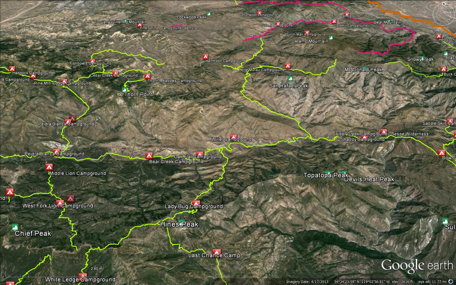
Sespe River Trail Survey - 02-28-2017 - by Los Padres Forest Association| Link: | Sespe River Trail |
| Date: | 02-28-2017 |
| Surveyor Name: | Los Padres Forest Association |
| Trail description: | Some bad news to report along the Sespe. Â We had two reports come in this week showing substantial slides on different sides of the Sespe River Trail. Â Both were in places where there has been historical slide damage: 1. KERR SPRINGS: The pictures pretty much tell the story. Â This section of trail is just upstream from Kerr Spring and was reworked about 5-7 years ago. Â The trail went along the base of a large slide and it looks like all the rain made that slide active once again. 2. SESPE SADDLE: The trail heading from Alder Creek to the Sespe, just as you head West and crest at the Saddle the trail wraps around to the north with some pretty dramatic exposure. Â This section of trail was worked a few years back but remained narrow and scary. Â It was reported this week as impassable, even making backpackers retreat rather than risk passing along the slide. Â We've seen backpackers have to drop crosscountry down to the Sespe here as well in years past. |
| Mode of transport: | Hike |
| Trail condition: | Non existent |
| Images: | Sespe Map of Current Slides, Tom Harrison Basemap Photo JMartinez; Kerr Spring Slide Photo JMartinez; Kerr Spring Slide Photo KMiller; Sespe Saddle looking West, note the high flow along the Sespe. |
Sespe River Trail Survey - 02-25-2017 - by Keith Miller| Link: | Sespe River Trail |
| Date: | 02-25-2017 |
| Surveyor Name: | Keith Miller |
| Trail description: | We were attempting to access sespe creek from dough flat trail head, but got turned around just after climbing out of alder creek on the sespe river trail. Â After crossing the saddle between the two, the first drainage crossing to the west is severely washed out and not safely passable. Â We attempted to cross, but the hillside is not stable and we turned around at the beginning where there is a bit of exposure (if one were to slide off the trail as they would go over a 15ft cliff). Â The trail continuing west looked like it was in reasonably good shape, but a little overgrown. Â Climbing up from alder creek was relatively easy to follow, but overgrown near the saddle |
| Mode of transport: | Hike |
| Trail condition: | Hard to follow |
Sespe River Trail Survey - 02-15-2017 - by Kevin Fox| Link: | Sespe River Trail |
| Date: | 02-15-2017 |
| Surveyor Name: | Kevin Fox |
| Trail description: | Trail is in great shape to Bear Creek camp. Â Then in good shape, with the above mentioned gillies, from Bear to Willet. I hiked from Piedra Blanca to Willet on Saturday 2/11. There had been rain on Friday 2/10 and off and on during the day on Saturday with some of the side creeks dying the whole Sespe a chocolaty brown. Â Attempting the 2 crossings of the Sespe between PB and Willet were significant factors for a number of people that day. Â There were a few groups that either got to Bear creek and stayed put or decided to turn around and return to the car not willing to risk the river. Â These folks were a bit disappointed to not make the hot springs. Â Exploration of the canyon beyond Willet was restricted as no one was willing to attempt the third river crossing due to depth and speed. In an effort to help those who come next, see links to the two stream gauges below: Â javascript:nicTemp();Â - This is upstream from Piedra Blanca TH javascript:nicTemp();Â Â - This is below the canyon carved by the Sespe On 2/11 the Sespe near Wheeler springs was at 100cfs and the Sespe near Filmore was at 380 cfs. Â At these levels, on a 6'3" guy, the first river crossing at Bear Creek was thigh deep and moving quickly. Â The second river crossing was waist deep but moving slowly. Â Dogs are not a good idea at these flows. |
| Mode of transport: | Hike |
| Trail condition: | Good shape and easy to follow |
Sespe River Trail Survey - 01-31-2017 - by Los Padres Forest Association| Link: | Sespe River Trail |
| Date: | 01-31-2017 |
| Surveyor Name: | Los Padres Forest Association |
| Trail description: | We received a report from the Sespe Trail from a couple who hiked from Piedra Blanca down to Willet. Â Trail is in typical good shape with a few sections that are being rutted by the rain (I think there are already pictures of those sections here on HLP). Â Crossings were not too hard but did require your feet to get wet. The biggest issue was that the spur trail up to the hot springs was washed out and sketchy enough for them not to make it up to the hot spring - wow! |
| Mode of transport: | Hike |
| Trail condition: | Good shape and easy to follow |
Sespe River Trail Survey - 08-19-2016 - by Anonymous Surveyor| Link: | Sespe River Trail |
| Date: | 08-19-2016 |
| Surveyor Name: | Anonymous Surveyor |
| Trail description: | Very little water. Found some at Bear Creek and Willet. |
| Mode of transport: | Hike |
| Trail condition: | Good shape and easy to follow |
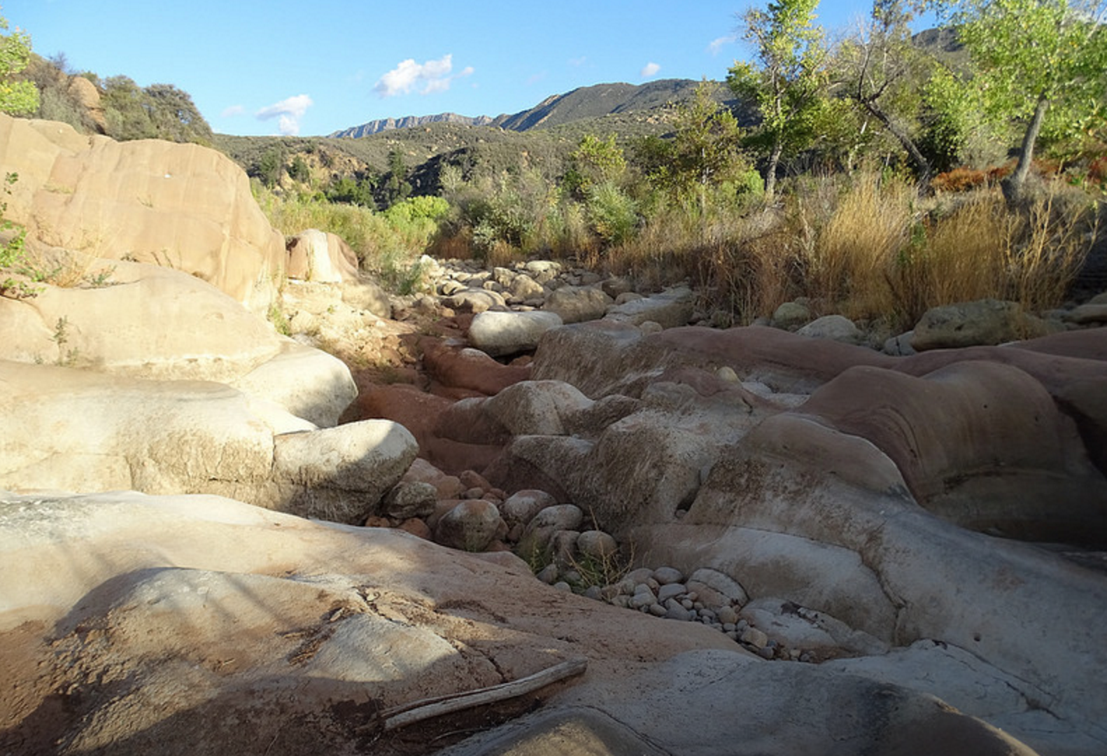
Sespe River Trail Survey - 08-13-2016 - by Anonymous Surveyor| Link: | Sespe River Trail |
| Date: | 08-13-2016 |
| Surveyor Name: | Anonymous Surveyor |
| Trail description: | No water in the creek. Went to the first 2 creek crossings to find both completely dry. |
| Mode of transport: | Hike |
| Trail condition: | Good shape and easy to follow |
Sespe River Trail Survey - 03-24-2016 - by Fredrick W Heiser| Link: | Sespe River Trail |
| Date: | 03-24-2016 |
| Surveyor Name: | Fredrick W Heiser |
| Trail description: | Trail from the last crossing of the Sespe River to Shady Campsite in mostly good but one section by the river badly overgrown  and a landslide on the uphill making things dicey. Not for people with acrophobia or vertigo. |
| Mode of transport: | Hike |
| Trail condition: | Needs some work |
| Condition details: | Good for most of the time but where it is bad it is horrible. |
Sespe River Trail Survey - 02-13-2016 - by JO| Link: | Sespe River Trail |
| Date: | 02-13-2016 |
| Surveyor Name: | JO |
| Trail description: | Hiked to Willet's. Â There were 71 cars in the parking lot by 10 AM. Â Lot's of water coming out of piedra blanca creek crossing. Â Plenty of water coming down all of the side canyons too, if sespe creek water isn't your flavor of water that you prefer. |
| Mode of transport: | Hike |
| Trail condition: | Good shape and easy to follow |
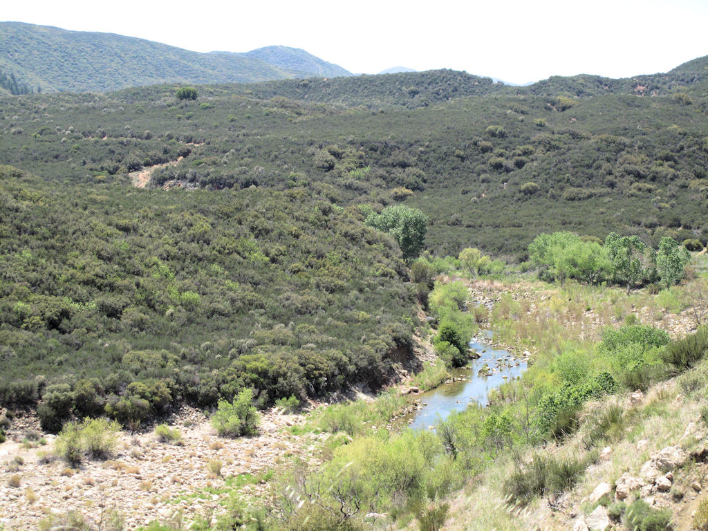
| Images: | piedra blanca creek and sespe river trail Anyone know if that's San Rafael peak poking up in the background? |
Sespe River Trail Survey - 01-23-2016 - by Chester| Link: | Sespe River Trail |
| Date: | 01-23-2016 |
| Surveyor Name: | Chester |
| Trail description: | Hiked to Willet two weekends in a row, water flowing through most parts of the Sesepe which was good to see. a couple sections with serious rain water erosion and some trees blocking the path about a 1/4 past bear creek after you cross the creek. see pictures. |
| Mode of transport: | Hike |
| Trail condition: | Good shape and easy to follow |
| Images: | The Beautiful Sesepe erosion approx 7miles from trail head erosion approx 7miles from trail head downed trees nr bear creek |
Sespe River Trail Survey - 10-03-2015 - by Los Padres Forest Association| Link: | Sespe River Trail |
| Date: | 10-03-2015 |
| Surveyor Name: | Los Padres Forest Association |
| Trail description: | Hiked from Piedra Blanca Trailhead down past Bear Creek. Â Trail is in great shape. Â The creek is not flowing but there are a few pools between Bear and PB if you know where to look. Â Beautiful day! |
| Mode of transport: | Hike |
| Trail condition: | Good shape and easy to follow |
| Images: | Dry pools upstream from Bear Creek, photo Benjamin Roudenis |
Sespe River Trail Survey - 10-17-2015 - by Anonymous Surveyor| Link: | Sespe River Trail |
| Date: | 10-17-2015 |
| Surveyor Name: | Anonymous Surveyor |
| Mode of transport: | Hike |
| Trail condition: | Good shape and easy to follow |
Sespe River Trail Survey - 05-11-2015 - by Hike Los Padres| Link: | Sespe River Trail |
| Date: | 05-11-2015 |
| Surveyor Name: | Hike Los Padres |
| Trail description: | Water along the entire stretch of the Sespe from Piedra Blanca to Alder Creek. Â The trail is wide open most of the way but starts to get overgrown as you approach Alder Creek at the last crossing of the Sespe. Â It is brushy on the last drop down to Alder at Shady Camp. |
| Mode of transport: | Hike |
| Trail condition: | Needs some work |
Sespe River Trail Survey - 04-11-2014 - by Anonymous Surveyor| Link: | Sespe River Trail |
| Date: | 04-11-2014 |
| Surveyor Name: | Anonymous Surveyor |
| Trail description: | All downed trees were removed from Piedra Blanca to the Hot Springs junction. Â Trail is in great shape. |
| Mode of transport: | Hike |
| Trail condition: | Good shape and easy to follow |


 Survey / Report Form - Please click this box to open the form.