 Use Marker Groups
 Wolf 2002
Piru 2003
Day 2006
Zaca 2007
Gap 2008
La Brea 2009

The Franklin Trail provided access for decades for many an outdoor adventurer, hunter, fisherman and backcountry explorer for many decades until things began to change after World War II, especially as avocado ranching became more and more prominent. About the same time Carpinterians were first venturing over the Santa Ynez Mountains to explore the mysteries of the backcountry, Santa Barbara Judge R.B. Ord introduced the Mexican avocado to the area. By the 1950s a number of varieties were becoming commercially successful, among them the Fuerte and the Hass.
In Carpinteria, ranches such as those owned by the Franklin families and others began to change hands and this shift in ownership accelerated in the early 1970s when the Carpinteria Valley became a mecca for commercial flower growing. Over time a wide swath of valley land stretching along the base of the mountains from Santa Monica Canyon east to the County were developed either for avocados or nursery related businesses. By the mid 70s public access to the mountains ground to a halt and after the Romero Fire in 1971, brush rapidly closed in what was left of the upper parts of the Franklin Trail.
Access: Park at the Juncal Gate and take the Murieta Road to Jameson Lake and then once you reach the old sign head down the side road to trail.


 Franklin Trail North Survey - 05-21-2025 - by Diane Soini
| Link: | Franklin Trail North |
| Date: | 05-21-2025 |
| Surveyor Name: | Diane Soini |
| Trail description: | I went down to explore the Jameson end of the trail and discovered the old parking area was washed away, the sluice was broken and the start of the trail is not readily apparent. I do not know what the rest of the trail is like but the devastation at the mouth of the canyon doesn't look promising. |
| Mode of transport: | Hike |
| Trail condition: | Needs some work |
| Condition details: | The start of the trail obscured and old parking area washed away |
| Images: | The trail should start here |
Franklin Trail North Survey - 04-01-2022 - by Adam Donald| Link: | Franklin Trail North |
| Date: | 04-01-2022 |
| Surveyor Name: | Adam Donald |
| Trail description: | A fair amount of bushwhacking required from the crest down to Alder Creek Camp. A large rockslide has obscured one section of the trail, but mostly easy to follow until you reach the creek crossings. There are flagging tape markers and cairns, but it is easy to get off track, especially when going uphill (south) in the segment above Alder Creek Camp. Continuing down to Jameson Reservoir is steep but easy to follow. The erosion barrier/retaining beams shown in the LPFA 2016 post could use some restoration. Tons of pretty wildflowers, and plenty of water in the creek starting just below the camp. Some bear tracks following the trail, be sure to make noise around blind turns where there is heavy brush. |
| Mode of transport: | Hike |
| Trail condition: | Needs some work |
| Images: | |
Franklin Trail North Survey - 11-19-2021 - by Los Padres Forest Association| Link: | Franklin Trail North |
| Date: | 11-19-2021 |
| Surveyor Name: | Los Padres Forest Association |
| Trail description: | LPFA Trail Crew and volunteers teamed up and spent a couple weeks throughout summer and fall 2021 working on the North Franklin Trail. Work concluded November 19, 2021. We were able to clear the trail from the Jameson Trailhead up to Alder Camp. This included brushing, clearing downed trees and fixing tread along the entire stretch up to camp. The trail from Alder up to Divide Peak OHV remains brushy and steep but is followable. We'll be back in 2022 to continue that effort. You'll also notice some improvements at Alder Creek Camp and a new trailhead sign compliments of the FS and some help from local Scout Troop 50. Enjoy.... |
| Mode of transport: | Array |
| Trail condition: | Needs some work |
Franklin Trail North Survey - 03-05-2021 - by Anonymous Surveyor| Link: | Franklin Trail North |
| Date: | 03-05-2021 |
| Surveyor Name: | Anonymous Surveyor |
| Trail description: | Once you drop into the canyon the vegetation is over grown. Starting about .75 miles from the bottom to the aqueduct the dead fall is everywhere making it hard to navigate. Boulder hopping in the creek would be easier then using the path. |
| Mode of transport: | Hike |
| Trail condition: | Hard to follow |
Franklin Trail North Survey - 04-12-2020 - by James| Link: | Franklin Trail North |
| Date: | 04-12-2020 |
| Surveyor Name: | James |
| Trail description: | Lots of poison oak |
| Mode of transport: | Bicycle |
| Trail condition: | Hard to follow |
| Condition details: | Very overgrown, hard to follow, especially at the creek crossings |
Franklin Trail North Survey - 11-05-2018 - by Jonathan Rocque| Link: | Franklin Trail North |
| Date: | 11-05-2018 |
| Surveyor Name: | Jonathan Rocque |
| Trail description: | I backpacked up Franklin Trail to Alder Creek Camp. The canyon was beautiful and the creek flowing well. There was evidence of debris flows in the creek. This made picking up the trail challenging at the creek crossings. There are sections of the old flume littering the trail and creating a hazard with some boards with nails sticking out of them. Once out of the lower creek, the trail became easier to follow. There were several downed trees across the trail and many smaller branches and dead trees in the path of the trail. It appeared most of these were due to the fires. There are several small slides along the canyon wall which are a hazard, particularly with a heavy pack. I had trekking poles which were almost a necessity to keep my footing on loose shale. Overall, a beautiful and challenging hike with spectacular views from the top. Lots of trail rehabilitation needed to make it safer and easier to follow. |
| Mode of transport: | Hike |
| Trail condition: | Hard to follow |
| Condition details: | Trail was obviously affected by recent fires and debris flows |
| Images: | Heading toward the flume Flowing creek Littered flume Switchbacks with loose terrain Views from above. About 0.25 mi from Alder Creek Camp |
Franklin Trail North Survey - 07-15-2017 - by Los Padres Forest Association| Link: | Franklin Trail North |
| Date: | 07-15-2017 |
| Surveyor Name: | Los Padres Forest Association |
| Trail description: | The LPFA spent a few hours clearing the Franklin Trail from the flume up to Alder Creek Camp. Â The trail was in really nice shape but we cleared a few tight areas and brushed here and there as needed. Â Most of our focus was spent clearing a tree that was spilling out across the trail about 40 yards below Alder Camp. |
| Mode of transport: | Hike |
| Trail condition: | Good shape and easy to follow |
| Images: | Alder Tree before and after. |
Franklin Trail North Survey - 07-06-2017 - by La Foote| Link: | Franklin Trail North |
| Date: | 07-06-2017 |
| Surveyor Name: | La Foote |
| Trail description: | We hiked up from Carp High on FT South to DP road, and then down past Alder Camp to Jameson and back.  Trail was more brushy on this side but still easy to follow. I had my pruning shears with me so I did some random pruning here and there on obvious overhanging branches.  Poison oak around, but relatively avoidable. Funny to see the toilet just sitting there on the side of the trail prior to entering camp. No water flowing in washes above camp, but flowing below camp. Water flowing at Alder Creek Dam, no water in flume. Flume is being worked on with many new wooden struts in place in the initial section. A hot, long gruel=tastic hike especially re=ascending back up from Alder to the road. Glad to finally check this off my list!  I'd like to go back and see some water flowing down that flume. Total trip time 5 hours each way, 10 hours total from Carp High to Jameson and back. Pros:  Water, shade, lingering wildflowers, dragonflies and butterflies. Cons: Lots of biting flies and other pesky flying insects in the woody shaded sections by creek. |
| Mode of transport: | Hike |
| Trail condition: | Good shape and easy to follow |
Franklin Trail North Survey - 06-04-2016 - by Los Padres Forest Association| Link: | Franklin Trail North |
| Date: | 06-04-2016 |
| Surveyor Name: | Los Padres Forest Association |
| Trail description: | The LPFA joined forces with a plethora of other trail groups to host a trail project along the Franklin Trail as part of National Trails Day 2016. Â We worked 1 mile of the trail from the Jameson Trailhead up to Alder Camp. Â That section of trail is in great shape. The upper section from Divide Peak OHV to Alder Camp has been worked recently by MTF. Â It is passable but still needs some more work, what trail doesn't. Â All is all the trail is very very followable and is probably in better shape than its been in for quite some time. Â Go get some! Â More photos at the link below: https://www.facebook.com/LosPadresForestAssociation/posts/521405164651079 There was water along the entire trail as well. |
| Mode of transport: | Array |
| Trail condition: | Good shape and easy to follow |
| Images: | |
Franklin Trail North Survey - 11-10-2015 - by Valerie Norton| Link: | Franklin Trail North |
| Date: | 11-10-2015 |
| Surveyor Name: | Valerie Norton |
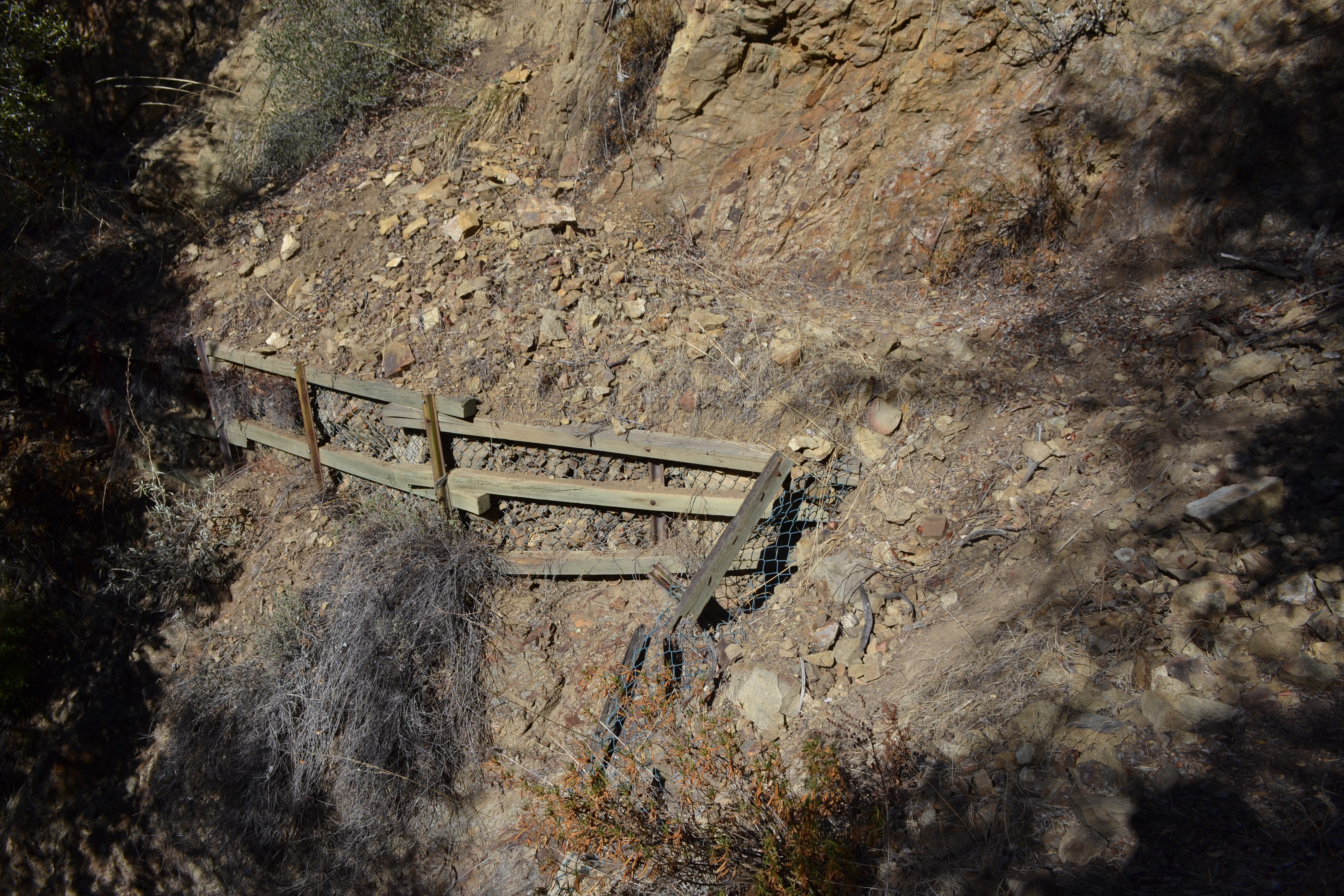
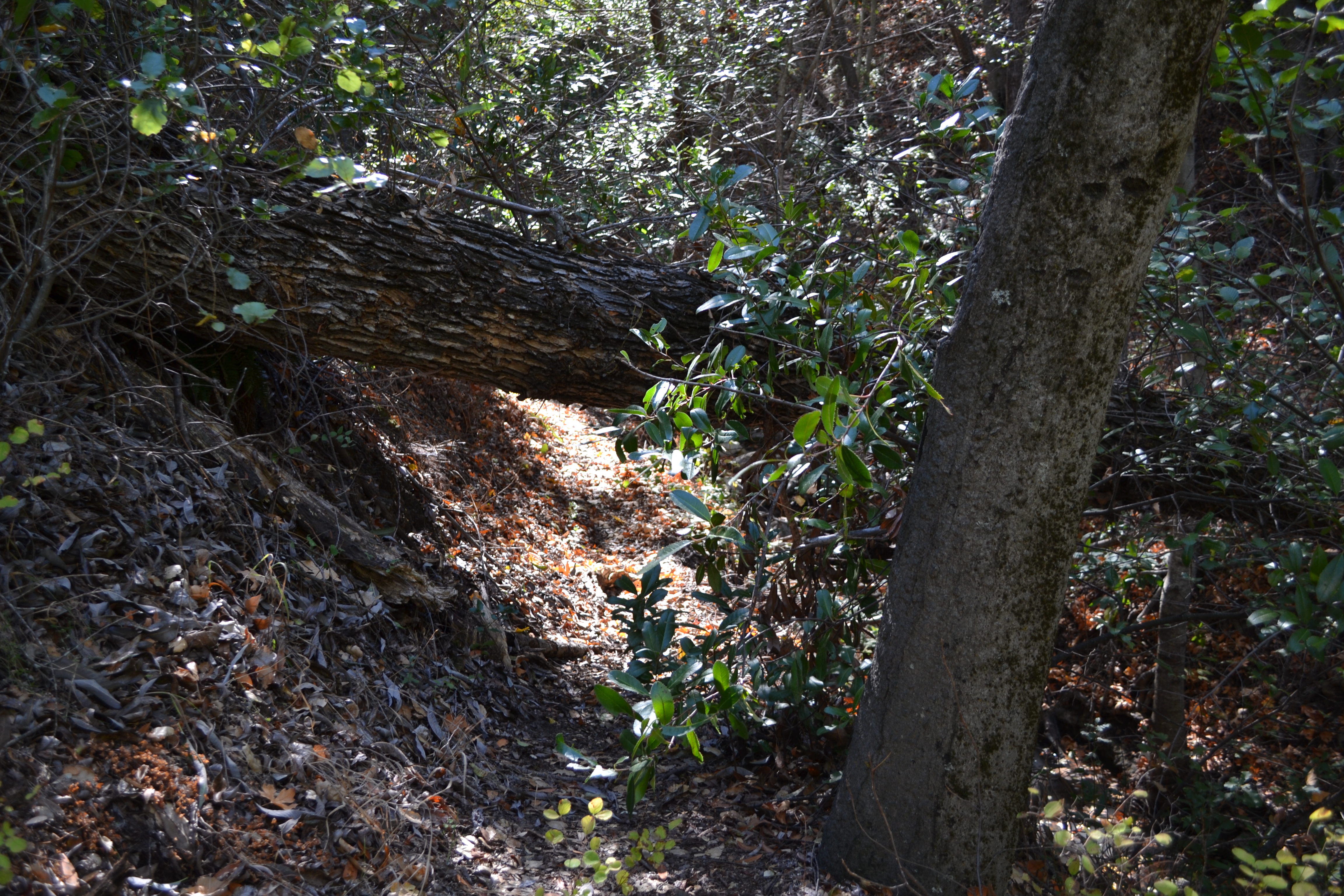
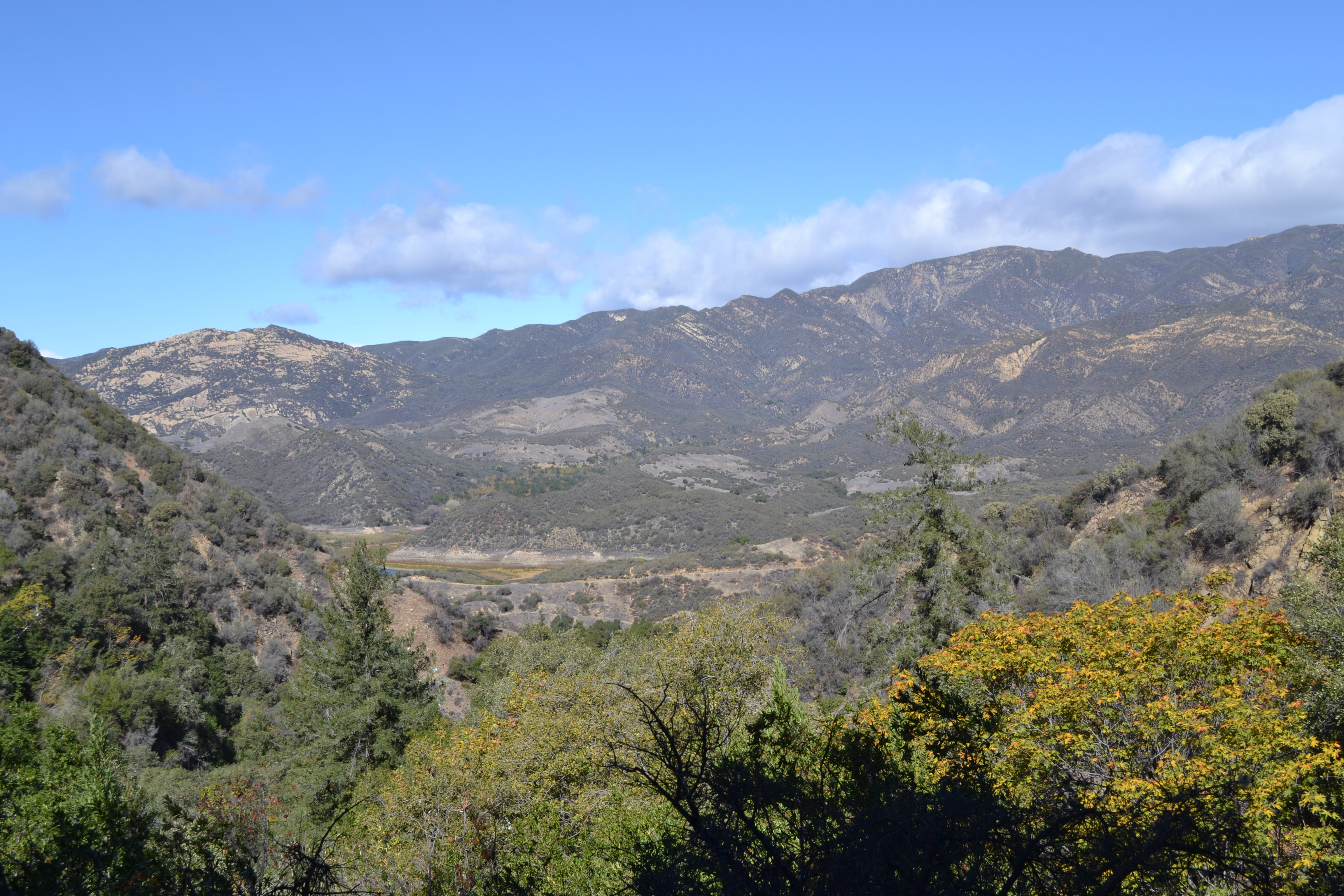
| Trail description: | The raspberries weren't making it hard to find the trail this time, so that's a plus. Â Otherwise, it is practically the same as three years ago. Â Downed trees (under 12") and a small spring make it not entirely obvious which way the trail goes toward the bottom and it looks like some people have looked for it climbing rather than up the canyon a few hundred more feet before climbing. Â There are more trees down above this (all under 24") and some of them are still growing. Â Above the first set of switchbacks is a slide area with improvements to hold in the trail, but half of these have failed and the other half have so much extra sluff that it feels a little dangerous. Â There are a couple spots near the top where the trail bed is failing, too, but otherwise it is good and obvious. Â Well, I thought it was obvious. Â Some switchbacks have been cut the last 5 feet or so. Â One spot where it crosses a dry creek shortly has seen many feet go up the creek instead of the trail on the other side, but the trail comes back quickly and it is currently flagged in this location. Â Brush is stabby from both sides, especially over the mile above camp. Â Different from 3 years ago: the front side exists! Â Another plus. |
| Mode of transport: | Hike |
| Trail condition: | Needs some work |
| Condition details: | trees down, narrow tread |
| Images: | failing trail supports, was like this 3 years ago too growing very low bridge, could be complicated to remove scenery |
Franklin Trail North Survey - 08-23-2014 - by Los Padres Forest Association| Link: | Franklin Trail North |
| Date: | 08-23-2014 |
| Surveyor Name: | Los Padres Forest Association |
| Trail description: | Trail could use some brushing and tread work but is very followable. Â Water was flowing nicely at the bottom of the creek. |
| Mode of transport: | Hike |
| Trail condition: | Needs some work |
| People Seen: | 0 |
 Survey / Report Form - Please click this box to open the form.