 Use Marker Groups
 Wolf 2002
Piru 2003
Day 2006
Zaca 2007
Gap 2008
La Brea 2009

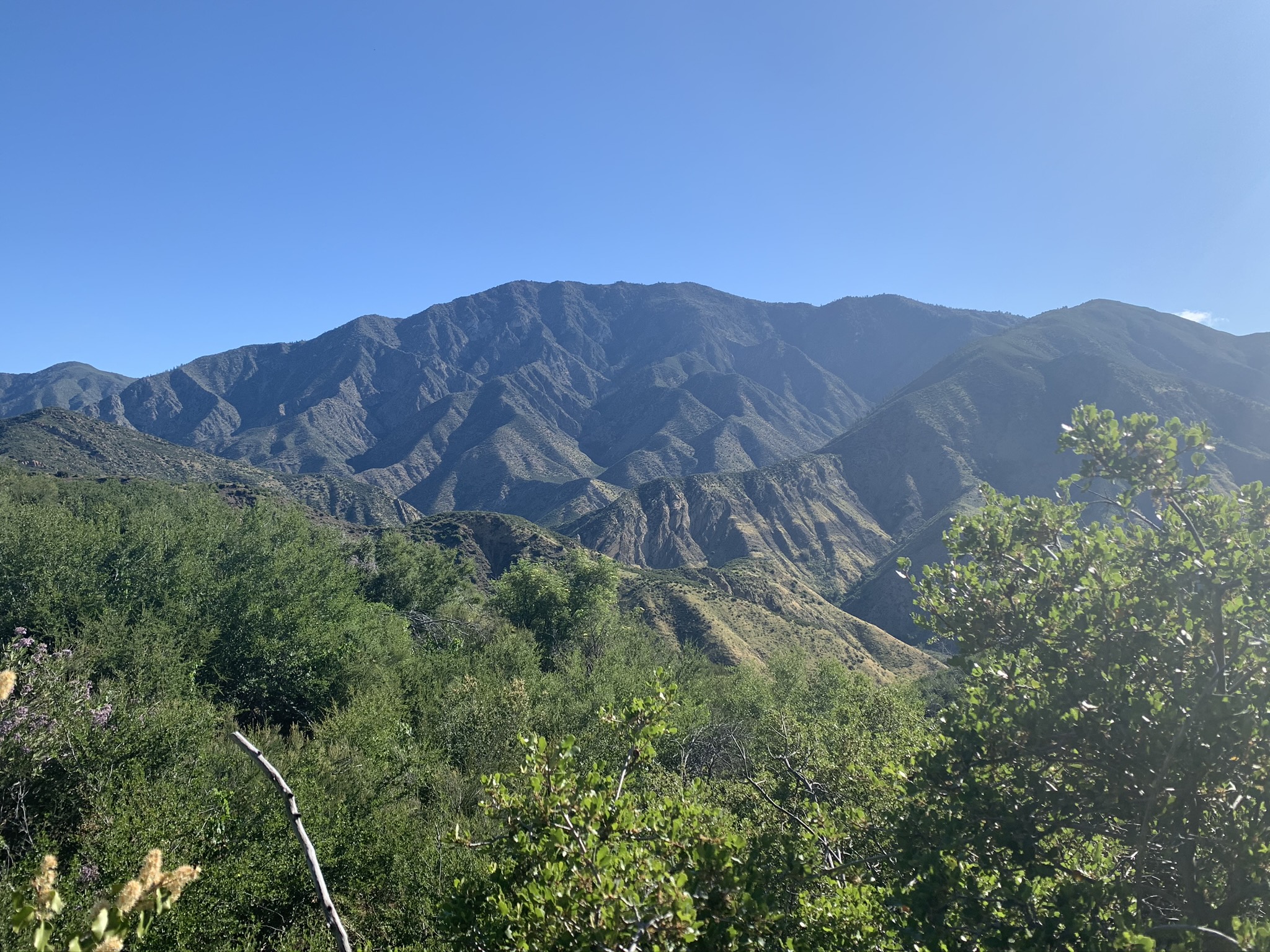
The Bucksnort Trail is a beautiful 2.99 mile trail in the Sespe Wilderness in Ventura County . The trail connects the Agua Blanca Trail (19W10) and the Alder Creek Trail (20W11). Please let us know if you have explored this trail recently.
Protecting the Sespe Condor Sanctuary
California condors are one of the most endangered species in the world. They were placed on the federal endangered species list in 1967. In the 1980's, due to a decreasing population, the U.S. Fish and Wildlife Service began a captive breeding program teaming with the Los Angeles Zoo and the San Diego Wild Animal Park. In 1987, a controversial decision was made to bring all remaining condors (22 individuals) into captivity and the last wild bird was captured in 1987. At that time, it was uncertain if the California condor would ever soar again in the wild. Through the efforts of many organizations and individuals, reintroduction of California condors began in 1992 and now has a population of over 230 animals living in the wild.
Today, the greatest threat to condors in the wild is human activity. Condors forage exclusively on dead animals; they are especially susceptible to lead exposure from carcasses left in the field and lead poisoning is often fatal. Also, interaction with humans increases exposure to food and microtrash. Condors feed microtrash (bottle caps, broken glass, litter, etc.) to their young which can lead to the death of the chick.
Sespe Condor Sanctuary
The Sespe Condor Sanctuary north of Fillmore, CA, was established in 1947 and expanded in 1951 to its current size of 53,000 acres. The Chief of the U.S. Forest Service intended the Sanctuary to be closed to all public entry except by permit however there are four one-quarter mile wide recreation travel corridors that can be used to hike through the Sanctuary – the Sespe Creek, Agua Blanca Creek, Alder Creek, and Bucksnort Trails.
The California condo was recognized as "endangered" in 1967 and received legal protection in 1972 when the U.S. Migratory Bird Treaty was amended to include vultures and certain other families of birds. With the passage of the Endangered Species Act of 1973, federal agencies were required to protect habitat and to prepare recovery plans that specified actions for its recovery.
The Sanctuary lies within the boundary of the Sespe Wilderness and is where the Forest Service provides critical habitat, wildlife refuge, and land management for the protection of the California condor. The Los Padres Condor Range and River Protection Act of 1992 established the Sespe Wilderness, which is also regarded as the "Home of the California Condor." These protections include the controlled public access to the Sanctuary to protect condor nesting, roosting, and foraging habitat. Survey data shows that California condors heavily use the Sanctuary to breed, nest, roost and forage.
As condors expand their use into their historic range, interactions with humans continue to be a concern. Refuges of high-quality habitat without human contact are necessary for the continued recovery of the species. Contaminants, primarily lead exposure from lead ammunition, continue to be a threat to the condor and the Sanctuary provides an area of protection from exposure.
The frequency of human trespassing in the Sanctuary, particular the Tar Creek area, exposes condors to human food and microtrash as well as direct human contact. This habituation increases the risk of injury to condors as documented by a condor that was strangled in a climbing rope in 2008. Adjacent to the Sanctuary and also closed to public entry is the Hopper Mountain National Wildlife Refuge. It is maintained as a refuge to protect the Sanctuary.


 Bucksnort Trail Survey - 05-29-2025 - by Holden
| Link: | Bucksnort Trail |
| Date: | 05-29-2025 |
| Surveyor Name: | Holden |
| Trail description: | Not too hard at all, until you go down the big mountain. Pain in the ass from then on, and the trail is a bit scattered and easy to get lost, especially when coming up again. you'll get kind of cut up but it's too hot to put on a shirt or pants. prepare for 2 hours up or down the last big hill. |
| Mode of transport: | Hike |
| Trail condition: | Hard to follow |
| Condition details: | Great 'til the Saddle |
| Images: | old oil equipment by Bucksnort |
Bucksnort Trail Survey - 04-07-2025 - by Rick Hayes| Link: | Bucksnort Trail |
| Date: | 04-07-2025 |
| Surveyor Name: | Rick Hayes |
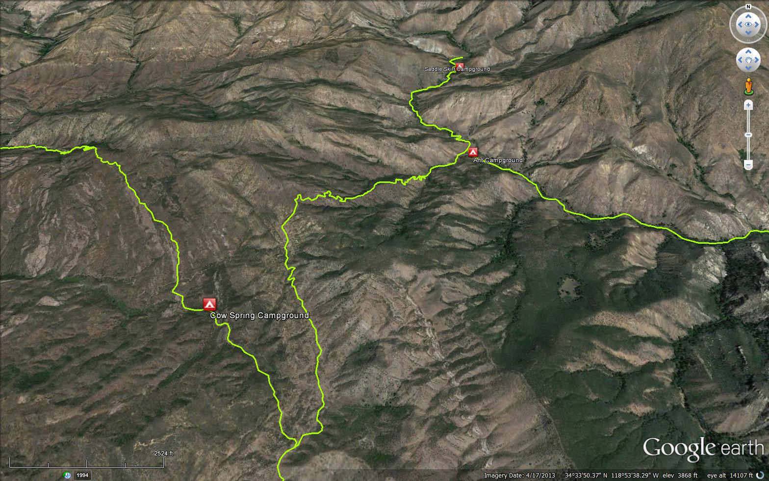
| Trail description: | Dough Flat to Ant Camp, then 1/2 mile up Agua Blanca creek. Day pack from Cow Spring/Bucksnort junction. Can wear shorts to the saddle before changing watersheds to drop down to Ant. Overgrown from saddle to Ant, need pants and long sleeves. Could do it with a full pack. Couldn't make it to Saddle Skirt, too overgrown, hard to follow and poison oak. Couldn't hike up the water itself, too much flow and too much debris. Found old marijuana grow 1/4 mile upstream from Ant Camp, on right side. Irrigation, trash, fertilizer bags, pesticide spray bottle. |
| Mode of transport: | Hike |
| Trail condition: | Needs some work |
Bucksnort Trail Survey - 11-03-2023 - by Jaime Santana| Link: | Bucksnort Trail |
| Date: | 11-03-2023 |
| Surveyor Name: | Jaime Santana |
| Trail description: | I was able to complete this route (started at dough flat trailhead, down to ant camp in one day, then went onward to log cabin and out through pothole trail to pothole trailhead). About halfway down the trail you begin the actual descent down to Ant camp. Use GPS if possible as it's very easy to lose the trail/no noticable trail exists at the flat just before the decent down to Ant camp. The trail is good until the descent down to Ant camp which is about half way. The descent down to Ant camp is extremely rough - it cannot be overstated how rough it is. extreme thick growth makes some parts extremely hard - no noticable trail exists at some parts and you are just pushing through extremely dense brush until you pick it up. This was possible going down, but I'm not sure I could have completed the trail going up it. use GPS to keep on trail so you can pick it back up when you find it, and expect some loose dirt on mountainsides. Recommend picking up water at bucksnort spring as you can find some there. Once at Ant camp you can get water at Agua Blanca no problem. Ant camp itself is in good shape and I was able to find easy water access about 200 yards up the river from Ant Camp |
| Mode of transport: | Hike |
| Trail condition: | Hard to follow |
| Condition details: | Extremely overgrown and hard to follow with very rough thick brush. Some sections are slippery with loose dirt |
Bucksnort Trail Survey - 10-13-2023 - by Luke M| Link: | Bucksnort Trail |
| Date: | 10-13-2023 |
| Surveyor Name: | Luke M |
| Trail description: | Trail down to Ant camp is very overgrown and hard to follow make sure you have GPS. I started the decent at about 5pm and I ended up turning back and doing the alder creek instead because I was running low on water and it was beginning to get dark. Would love to know what the water situation is like at Ant Camp this time of year. I would recommend having lots of water for this hike and filling up at Squaw spring on the Alder Creek trail on the way in. Do not underestimate the decent down to Ant Camp. |
| Mode of transport: | Hike |
| Trail condition: | Hard to follow |
| Condition details: | Decent down to ant camp is very over gown and can get lost without GPS |
Bucksnort Trail Survey - 04-09-2021 - by Addison Jerlow| Link: | Bucksnort Trail |
| Date: | 04-09-2021 |
| Surveyor Name: | Addison Jerlow |
| Trail description: | well worn from alder creek junction until the main decent to Ant Camp. Already very dry out there. No seasonal streams or water in Bucksnort Spring. The trail down to Ant is easy enough to follow since you can see the oaks that mark the camp for nearly the entire decent. Many of the switchbacks are hidden by chaparral at the turns, or have been cut (maybe unintentionally) to the point that the cuts look more like the trail than the real trail. Could use a little work to redefine the correct path. |
| Mode of transport: | Hike |
| Trail condition: | Needs some work |
Bucksnort Trail Survey - 03-19-2021 - by Jim Kenney| Link: | Bucksnort Trail |
| Date: | 03-19-2021 |
| Surveyor Name: | Jim Kenney |
| Trail description: | The trail junction from alder creek is well worn and easy to follow. After about 11/2 mile you will come to the saddle. At the saddle there is a flat head shovel head. Take the left and follow the trail. The trail is in fair to good shape to Ant camp. It is overgrown in places that require some bushwhacking and route finding. There are places where the switchbacks that have been cut- don’t take those please. There are places where the trail tread has been worn and some care is needed as it sloughs off to the downhill side. Ant camp is in good shape. Water is running. |
| Mode of transport: | Hike |
| Trail condition: | Needs some work |
| Condition details: | Shovel head |
Bucksnort Trail Survey - 02-21-2021 - by Dylan| Link: | Bucksnort Trail |
| Date: | 02-21-2021 |
| Surveyor Name: | Dylan |
| Trail description: | Went from the intersection with Alder Creek Trail to Ant Camp (and back) Trail in decent condition mostly, but very overgrown in some places. Easy to lose in a couple places, make sure you have proper navigation. Full body coverage required if you don't want to get chewed up by chaparral. Trekking poles also recommended, there are a few steep crumbly bits |
| Mode of transport: | Hike |
| Trail condition: | Needs some work |
Bucksnort Trail Survey - 11-17-2020 - by Fredrick W Heiser| Link: | Bucksnort Trail |
| Date: | 11-17-2020 |
| Surveyor Name: | Fredrick W Heiser |
| Trail description: | Followed Bucksnort from the intersection with Alder Creek trail to where it begins its descent. That part is in good shape. There were plenty of footprints and somebody has taken a dirt bike out here. :( The trail turns right as it leaves the second clearing, climbs a small hill, and then descends to Ant. At the top of the hill, the trail is very badly overgrown and I decided to go no further today. I got as far as the marker on the map I uploaded. |
| Mode of transport: | Hike |
| Trail condition: | Needs some work |
| Images: | |
Bucksnort Trail Survey - 05-15-2020 - by Christopher P. Lord| Link: | Bucksnort Trail |
| Date: | 05-15-2020 |
| Surveyor Name: | Christopher P. Lord |
| Trail description: | Came through Bucksnort on my way up the Agua Blanca. As I have reported previously the tread is mostly there but the trail desperately needs work and quite a bit of it. Be nice to someday get this one back in shape again as would be convenient for the hikers enjoying Ant Camp. This is me harping Bryan yet also willing to help. More details at the link below |
| Mode of transport: | Hike |
| Trail condition: | Needs some work |
| Images: | Blooming Yucca View of Cobblestone Mountain from Buchsnort |
Bucksnort Trail Survey - 05-03-2020 - by Fredrick W Heiser| Link: | Bucksnort Trail |
| Date: | 05-03-2020 |
| Surveyor Name: | Fredrick W Heiser |
| Trail description: | Didn't get all the way to Ant. The trail left to Cow Camp was full of hikers but didn't see anyone at all on Bucksnort Trail. Not even recent footprints. Plenty of water flowing from Bucksnort Spring. |
| Mode of transport: | Hike |
| Trail condition: | Good shape and easy to follow |
| Images: | |
Bucksnort Trail Survey - 06-22-2019 - by Christopher P. Lord| Link: | Bucksnort Trail |
| Date: | 06-22-2019 |
| Surveyor Name: | Christopher P. Lord |
| Trail description: | Came through Bucksnort on my way to Saddle Skirt. From the junction with Alder Creek trail and until starting the descent toward Ant is relatively smooth sailing aside from the small inconvenience of trail disappearing through the open Flat areas. Along the steep descent down the canyon is where things become more overgrown, however the tread is mostly there and still not very difficult for the casual observer to follow. The junction sign is horrible, lets get some new decals on that thing or something. A nice guerrilla site can be found about a half mile from the Alder junction here at: N34° 33' 15.8" W118° 53' 51.8" Keep in mind what goes in should be packed out, way to much crap is being left behind at Ant camp. More details at the link below. |
| Mode of transport: | Hike |
| Trail condition: | Needs some work |
| Images: | Bucksnort/Alder junction sign Bucksnort Guerrilla site views of cobblestone Descending to Ant Camp second large flat area |
Bucksnort Trail Survey - 02-04-2018 - by Los Padres Forest Association| Link: | Bucksnort Trail |
| Date: | 02-04-2018 |
| Surveyor Name: | Los Padres Forest Association |
| Trail description: | The trail is obvious enough to follow but getting a little brushy and a lot in need of tread work. Some obvious signs of people cutting the switchbacks in sections. The sign at the top is hard to read as it is rusted and faded. Really fun trail though and different that you hike out and drop down rather than climb up. Check it out sometime! |
| Mode of transport: | Hike |
| Trail condition: | Needs some work |
| Images: | Views from Bucksnort into the Agua Blanca at Ant Camp |
Bucksnort Trail Survey - 05-19-2017 - by Kara Hooper| Link: | Bucksnort Trail |
| Date: | 05-19-2017 |
| Surveyor Name: | Kara Hooper |
| Trail description: | We hiked the Bucksnort trail from the Dough Flat trail down to Ant Camp. It began in a very straightforward, easy to follow way for about the three quarters to one mile. Once we crossed into a new drainage and began descending down the side of the mountain, it was a skinny path and overgrown in places. However, we were able to stay with it. Coming back up it the next day, it looks more foreboding than it actually is. We came up the mountain in about one hour. |
| Mode of transport: | Hike |
| Trail condition: | Needs some work |
| Condition details: | a skinny trail that is at times hard to follow, but mostly easy to stick with. |
Bucksnort Trail Survey - 02-25-2016 - by Mark Subbotin| Link: | Bucksnort Trail |
| Date: | 02-25-2016 |
| Surveyor Name: | Mark Subbotin |
| Trail description: | Easy to follow first 1.4 lies from junction of Alder Creek Trail to where it begins descent into Agua Blanca drainage. Â Next 1.2 miles drop steeply; trail is narrow, brushy, several slides, switchbacks gone in several places; flagging placed at possible areas of confusion but trail not difficult to follow. Â Upon reaching creek crossing grade flattens out to sign marking junction with Agua Blanca trail. |
| Mode of transport: | Hike |
| Trail condition: | Needs some work |
| Images: | trail sign at start of Bucksnort trail typical lack of trail tread discernible tread in most locations sign at junction w/ Agua Blanca trail near Ant Camp |
 Survey / Report Form - Please click this box to open the form.