 Use Marker Groups
 Wolf 2002
Piru 2003
Day 2006
Zaca 2007
Gap 2008
La Brea 2009

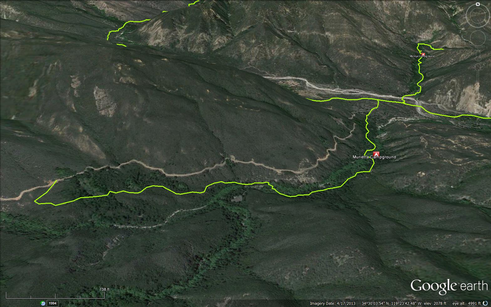
Drive up Matilija Canyon Road 5N13 to the locked car gate. Hike up the road, crossing two creeks, then take the trail to the left and then about 1 mile to the campsite.
This canyon was reported in folk tales to be a secret route for Joaquin Murieta, a Mexican bandit when he would visit Santa Barbara without being seen coming or going. A great deal of folklore has developed about this person but, actually the name was applied to a number of bandits waging war against the Yankees who had taken over their country. His name is generally spelled with just one "R' but several place names in this area all are spelled with two "TT"s. Murietta Canyon ascends to reach a divide that separates the Matilija drainage from the headwaters of the Santa Ynez River that flows west to the ocean, west of Lompoc some 70 miles away.


 Murietta Trail Survey - 01-14-2024 - by Los Padres Forest Association
| Link: | Murietta Trail |
| Date: | 01-14-2024 |
| Surveyor Name: | Los Padres Forest Association |
| Trail description: | The Murietta Trail has been closed due to storm damage since January 2023. LPFA surveyed the trail in January 2024. The trail is very overgrown. Passable from the lower trailhead up to Murietta Camp. Above Murietta Camp, the trail is non-existent until you get above the final creek crossing. From there to the upper TH is followable but very very overgrown. The trail needs substantial work above the camp. |
| Mode of transport: | Hike |
| Trail condition: | Hard to follow |
Murietta Trail Survey - 05-17-2025 - by Diane Soini| Link: | Murietta Trail |
| Date: | 05-17-2025 |
| Surveyor Name: | Diane Soini |
| Trail description: | I came over Murietta Divide from the Jameson Lake side. The dirt road was washed out in many areas wherever there was a side canyon starting right after the spring. Although I saw a cairn marking the Murietta trail where the upper portion meets the road, I did not have confidence the trail still exists so I did not follow. It did not help that the last trip report here that sounds like anyone went all the way to the road is from 2021. It would be helpful if anyone has hiked the complete trail could let us know if the whole trail is open. |
| Mode of transport: | Hike |
| Trail condition: | Needs some work |
| Condition details: | I did not trust the trail existed |
| Images: | Washout on the road coming over the divide. |
Murietta Trail Survey - 11-05-2022 - by Los Padres Forest Association| Link: | Murietta Trail |
| Date: | 11-05-2022 |
| Surveyor Name: | Los Padres Forest Association |
| Trail description: | The LPFA led a volunteer day maintaining the lower part of the Murietta Trail. We lightly brushed about a mile up the trail. Still more to do but the trail is holding up nicely after we last worked it in 2019. |
| Mode of transport: | Array |
| Trail condition: | Needs some work |
Murietta Trail Survey - 02-18-2022 - by bardley| Link: | Murietta Trail |
| Date: | 02-18-2022 |
| Surveyor Name: | bardley |
| Trail description: | this trail is now free of obstructions and easier to follow with thanks to a group of volunteers from boy scout troop 111 and friends. water is flowing freely at both trail / creek crossings. |
| Mode of transport: | Hike |
| Trail condition: | Good shape and easy to follow |
Murietta Trail Survey - 04-20-2021 - by Ryan Freeman| Link: | Murietta Trail |
| Date: | 04-20-2021 |
| Surveyor Name: | Ryan Freeman |
| Trail description: | From the trail head, follow the private service/fire road through a ranch style neighborhood. Please respect the private property and driveways. Soon after you pass the North Matilija Creek Trail junction (on your right), the Murietta Trail tee's off the service road to the left. The trail gets more and more shady up to Murietta Camp. After that, there's just one more creek crossing before going back up to the service road. There are a few overgrown spots that could use some work, but overall easy to follow. You can take the service road back to the trail head to create a lollipop loop. The trail is beautiful in Spring and littered with wild flowers! Much quieter trail than North Matilija Creek Trail. |
| Mode of transport: | Hike |
| Trail condition: | Good shape and easy to follow |
| Images: | View from Top of Murietta trail at a service road junction Overgrown Section Overgrown Section Wild Flowers! Creek |
Murietta Trail Survey - 03-16-2021 - by bardley| Link: | Murietta Trail |
| Date: | 03-16-2021 |
| Surveyor Name: | bardley |
| Trail description: | a great trail with many uncommon features not seen in the lower los padres. damp trail. ferns. easy to follow. currently a few downed tress across the trail in various spots, but easy to get over and will probably be gone soon. consider taking the loop up to the road and then back down to the parking area. great trail. great views. |
| Mode of transport: | Hike |
| Trail condition: | Good shape and easy to follow |
Murietta Trail Survey - 08-14-2020 - by Ron Wean| Link: | Murietta Trail |
| Date: | 08-14-2020 |
| Surveyor Name: | Ron Wean |
| Trail description: | Trail is in great condition. The camp is clean and in good condition also.however every good spot to put down a tent has a potential widow maker burnt oak tree looming over it!  There is still plentiful water in the creek.  Thanks to LPFA for getting this trail cleared recently! |
| Mode of transport: | Hike |
| Trail condition: | Good shape and easy to follow |
Murietta Trail Survey - 11-29-2019 - by Jim Kenney| Link: | Murietta Trail |
| Date: | 11-29-2019 |
| Surveyor Name: | Jim Kenney |
| Trail description: | Started this trail at 9 AM. The first mile is fairly flat with a little water that needed to be crossed. It took some finding to even spot where the trail connected past the road. We bushwacked through the trail as best as we could. This is a trail in name only. There is significant route finding that is needed to find your way to the trail camp. Once at the camp the trail is non existent.  There are frequent blow downs and trail work is needed to even see that a trail was there. I suggest maintaining the trail from Matilja cyn to Murietta trail camp.  The trail from the camp to the divide road has for the most part been absorbed back to forest. |
| Mode of transport: | Hike |
| Trail condition: | Non existent |
| Condition details: | There’s a trail there somewhere |
Murietta Trail Survey - 11-29-2019 - by LPFA| Link: | Murietta Trail |
| Date: | 11-29-2019 |
| Surveyor Name: | LPFA |
| Trail description: | Thank you all to the brave volunteers who came out for this epic bushwack! Ten of us (plus two goats) started off from the lower trailhead and hiked up to where the trail meets with the road, ~1.7 miles. The first half mile is possible to follow, but full of tall grass and downed branches. It is easy to lose the trail at any of the crossings, and at times the creek bed was more followable than the trail. Murietta Camp was wide open and clear of downed trees. After the camp, we lost the trail again and spent some time in the creek, before finding an old roadbed cut on the West side of the creek. The "trail" then climbs up and out of the creek bed, but is almost totally gone due to overgrown brush. About 1.3 miles up, we found some old check steps that were still in place, which was our only indication that we were still on the original trail. There were only a few large oaks (<20in) down across the trail. All the other burnt vegetation was wrist size and smaller. There are mostly vines, tall grass and Thomas Fire regrowth (sycamore, laurel sumac, scrub oak, ect.) that prevent you from walking on any real tread for 90% of the trail. The thick regrowth forces you hover slightly above the ground while walking, but does not give you the feeling of weightlessness. Awesome views with snow on all the peaks. Busy day at the Matilija gate with about 40 cars, but no one on the Murietta trail except us....... |
| Mode of transport: | Hike |
| Trail condition: | Hard to follow |
| Condition details: | #OptOutside Black Friday: Murietta Trail Scouting |
| Images: | The largest of the downed trees There's a goat in there somewhere... The camp The trail at mile 1.5 |
Murietta Trail Survey - 05-17-2019 - by Michael Sallwasser| Link: | Murietta Trail |
| Date: | 05-17-2019 |
| Surveyor Name: | Michael Sallwasser |
| Trail description: | Trail only exists as far as campsite. Disappears beyond that. |
| Mode of transport: | Hike |
| Trail condition: | Non existent |
Murietta Trail Survey - 09-11-2019 - by Dan Whelan| Link: | Murietta Trail |
| Date: | 09-11-2019 |
| Surveyor Name: | Dan Whelan |
| Trail description: | The fire damage has taken its tole on this trail You can follow the trail up to the camp ground through the sometimes head high grass and over the downed trees. Shortly after the camp ground the trail vanishes in heavy new plant growth. A wall of thorny plans turned me back. I dropped down to the creek and with the trail on my GPS I went on. There are a few spots where you can see or since the trail being there but without the gps I would have never known. Beyond the camp ground the trail is practically non existent until just before it ties back in with the road. The camp ground is in decent shape with evidence of recent use. There is water in the creek all the way up |
| Mode of transport: | Hike |
| Trail condition: | Non existent |
Murietta Trail Survey - 05-07-2019 - by Stephen S| Link: | Murietta Trail |
| Date: | 05-07-2019 |
| Surveyor Name: | Stephen S |
| Trail description: | The trail from the bottom of the camp was still fairly easy to follow with a flag helping us find the trail over a creek crossing. Beyond the camp was completely overgrown and we abandoned the trail and ended up using the road. |
| Mode of transport: | Hike |
| Trail condition: | Hard to follow |
| Images: | up the creek during a crossing |
Murietta Trail Survey - 01-04-2019 - by C Day| Link: | Murietta Trail |
| Date: | 01-04-2019 |
| Surveyor Name: | C Day |
| Trail description: | This trail has sustained a lot of damage from fire and flood. Â If it is not worked on, it will probably be lost. Â The camp, on the there hand, is in good shape. Â There are no problems on the road, for those wanting to hike the loop. Â I would recommend going up the road and down the trail. Â There is no sign now to mark the upper trailhead. |
| Mode of transport: | Hike |
| Trail condition: | Hard to follow |
| Condition details: | Aside from a few trees blocking the trail, it is not too bad from the bottom to the camp; after that is is in bad condition, with parts of the trail gone. Some bushwhacking required. |
| Images: | Example of downed tree blocking the trail Tre trail is in here somewhere Upper trailhead is center right |
Murietta Trail Survey - 12-10-2018 - by Jim Kenney| Link: | Murietta Trail |
| Date: | 12-10-2018 |
| Surveyor Name: | Jim Kenney |
| Trail description: | It took some finding to even spot where the trail connected with the road. We bushwacked through the trail as best as we could. This is a trail in name only. There is a significant route finding that is needed to find your way to the trail camp. Once at the camp the trail is managable with still frequent blow downs and trail work needed. |
| Mode of transport: | Hike |
| Trail condition: | Hard to follow |
| Condition details: | Murrietta Trail to the Divide Rd |
| Images: | |
Murietta Trail Survey - 01-03-2017 - by Matt Swider| Link: | Murietta Trail |
| Date: | 01-03-2017 |
| Surveyor Name: | Matt Swider |
| Trail description: | Hiked up the trail to the forest rte 5N13 up to the spring of the right side of the road. Â Trail from a bit past the Murietta camp to the road was a bit overgrown in areas, but still very passable. Â Once we got on the road we encoutered a downed oak tree limb that blocked the road. Â Fortunately I brought a hand saw and we cleared about half the road, see the pictures. Â Just below the spring a few hundred yards we encountered the biggest ladybug gathering I have ever seen. Â And I have seen some pretty good sized ones on the trails in the area. Â About 20 feet on both sides of the road were loaded with lady bugs. Â Had hoped to hike up to the divide but one in our group was tiring, so we turned around at the spring. Â |
| Mode of transport: | Hike |
| Trail condition: | Good shape and easy to follow |
| Images: | oak limb blocking road Road now partially cleared At the spring Forest Rte 5N13 view |
Murietta Trail Survey - 04-30-2016 - by Los Padres Forest Association| Link: | Murietta Trail |
| Date: | 04-30-2016 |
| Surveyor Name: | Los Padres Forest Association |
| Trail description: | Ojai Ranger District organized twelve volunteers to work on the Murietta Trail. Eight from the lower trailhead with hand tools and four from the top using a chainsaw. There is still another one to two days of work, but a great start and improvement.  |
| Mode of transport: | Array |
| Trail condition: | Needs some work |
Murietta Trail Survey - 05-03-2016 - by Anonymous Surveyor| Link: | Murietta Trail |
| Date: | 05-03-2016 |
| Surveyor Name: | Anonymous Surveyor |
| Trail description: | Trail is fine until camp but overgrown up to the fire road. Lots of poison oak. No water. |
| Mode of transport: | Hike |
| Trail condition: | Good shape and easy to follow |
Murietta Trail Survey - 11-20-2015 - by Bryan Conant| Link: | Murietta Trail |
| Date: | 11-20-2015 |
| Surveyor Name: | Bryan Conant |
| Trail description: | Trail is very brushy from the road down to the camp. Â Some branches in the trail. Â Both creek crossings are hard to follow, especially with a bike. Â The trail gets much better as you get below the camp. Â Hot in the sun and cool in the shade. Â A great short hike out of Ojai. Â Didn't see another person. |
| Mode of transport: | Bicycle |
| Trail condition: | Needs some work |
 Survey / Report Form - Please click this box to open the form.