 Use Marker Groups
 Wolf 2002
Piru 2003
Day 2006
Zaca 2007
Gap 2008
La Brea 2009

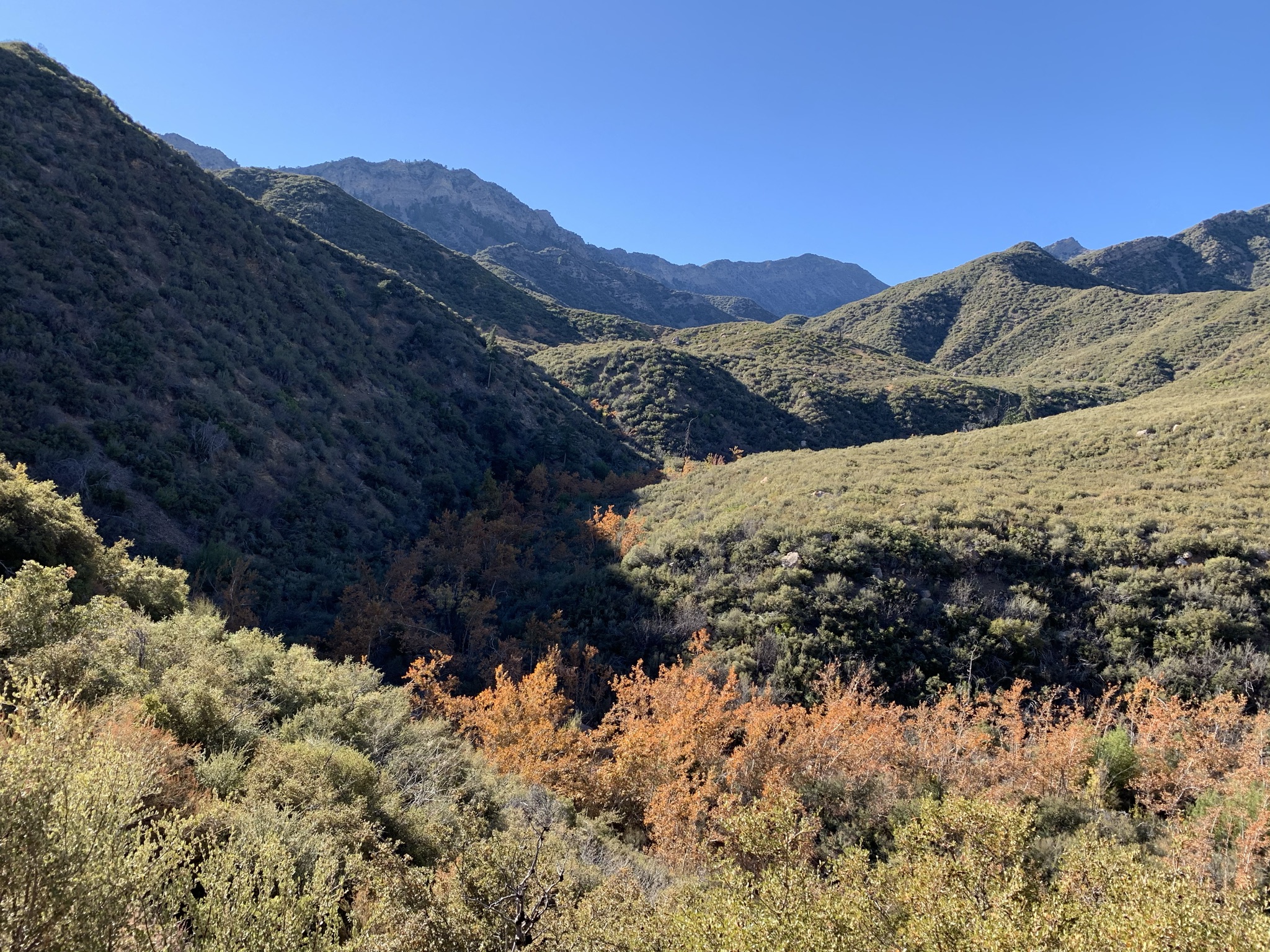
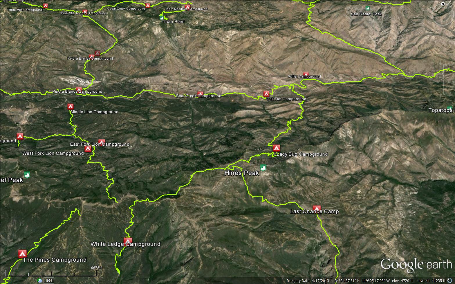
Park along north side of Highway 150 adjacent to Summit School. Hike one mile up Sisar Road to locked gate. Respect private property. Hike another 2.1 miles until the Red Reef Trail leaves the road at a switchback. (If you stay on the road, you will reach Nordhoff Ridge after 4.5 miles).
Follow the trail for one mile to White Ledge Camp which offers three streamside sites set in a thick stand of laurel trees beside a year-round stream. The trail climbs steeply another 1.7 miles to Hines Peak Road. Turn right (east) and go .6 miles to the Sespe Wilderness boundary at the steel pipe barrier. Continue east for 2.4 miles to where the old road ends beyond its junction with Last Chance Trail (21W09), northwest of Hines Peak.
Ladybug Camp is 2.3 miles northeast from the ridge and is shaded by big cone Douglas-firs. Ladybug Spring is about 600 feet south (uphill) from the camp and has year-round water. This area is a famous overwintering spot for ladybird beetles. After 5.6 miles, the trail ends at the junction with the Sespe River Trail (20W13). Continuing east (right) you’ll reach Willett Camp after 1.3 miles and Sespe Hot Springs after 6.7 miles. Hiking west (left) takes you to Piedra Blanca Trailhead after 9 miles.


.JPG)
.JPG)
.JPG)


 Red Reef Trail Survey - 05-21-2025 - by Diane Soini
| Link: | Red Reef Trail |
| Date: | 05-21-2025 |
| Surveyor Name: | Diane Soini |
| Trail description: | Hiked this trail from the ridge down to the Sespe. Overall it is followable but there are places with fallen burned trees and one where I had to take my pack off and crawl underneath. The trail gets brushy at times and is tick heaven. I did not see a Ladybug camp or any place you could camp. I saw no water until where the trail crosses Timber Creek a little above Harris Tunnel. I may have left my pot containing a stove, lighter, spoon and green bandana at the creek on the south side of Harris Tunnel. If anyone finds it and wants to return it, my fist and last name, all one word, at gmail is my email. |
| Mode of transport: | Hike |
| Trail condition: | Needs some work |
| Condition details: | Brushy, ric-rack areas sketchy, saw no camps |
Red Reef Trail Survey - 04-27-2025 - by Anonymous Surveyor| Link: | Red Reef Trail |
| Date: | 04-27-2025 |
| Surveyor Name: | Anonymous Surveyor |
| Trail description: | Light rain. Road and trail are in good condition. |
| Mode of transport: | Hike |
| Trail condition: | Good shape and easy to follow |
Red Reef Trail Survey - 04-01-2025 - by Rick Hayes| Link: | Red Reef Trail |
| Date: | 04-01-2025 |
| Surveyor Name: | Rick Hayes |
| Trail description: | Hiked from Nordhoff road down Red Reef to Sespe with full pack. Need pants, long sleeves, trekking poles entire route. Brush and deadfall. Water flowing at Ladybug and Horsethief camp. Poison Oak from Horsethief to Sespe. |
| Mode of transport: | Hike |
| Trail condition: | Needs some work |
Red Reef Trail Survey - 09-29-2024 - by A. Robinson | Link: | Red Reef Trail |
| Date: | 09-29-2024 |
| Surveyor Name: | A. Robinson |
| Trail description: | The trail is hard to follow and near completely overgrown at the lowest elevation crossing of Timber Creek. As it climbs from Sespe it is in need of brushing and limbing, but is passable and easily followed. Blow downs become more frequent as it climbs, and there are many spots that need tread work due to slides. One particular ridge before Ladybug has an extremely exposed slide with blow downs hanging in the way. The entrance to Ladybug is blocked by several trunks. Above Ladybug it is mostly clear but could use some brushing. |
| Mode of transport: | Hike |
| Trail condition: | Needs some work |
| Condition details: | Overgrown, blow downs, slides, treadwork needed |
| Images: | One of the sections above Ladybug that is in good shape. |
Red Reef Trail Survey - 12-31-2022 - by Los Padres Forest Association| Link: | Red Reef Trail |
| Date: | 12-31-2022 |
| Surveyor Name: | Los Padres Forest Association |
| Trail description: | LPFA spent 2022 working on the Red Reef Trail, in particular the wilderness section. The entire Wilderness portion of Red Reef has been brushed, logged and treaded where needed. Great shape and easy to follow, get it while you can cause that brush is already trying to retake the trail....... |
| Mode of transport: | Array |
| Trail condition: | Good shape and easy to follow |
Red Reef Trail Survey - 06-18-2022 - by Douglas Edwards| Link: | Red Reef Trail |
| Date: | 06-18-2022 |
| Surveyor Name: | Douglas Edwards |
| Trail description: | |
| Mode of transport: | Hike |
| Trail condition: | Good shape and easy to follow |
| Images: | |
Red Reef Trail Survey - 06-03-2022 - by Addison Jerlow| Link: | Red Reef Trail |
| Date: | 06-03-2022 |
| Surveyor Name: | Addison Jerlow |
| Trail description: | Good from road to White Ledge Camp. Brushy but easy to follow from White Ledge Camp to Chief Peak Road. A highway for almost the entire wilderness portion of the trail, only one small (maybe .25mi) section still overgrown as you drop to Timber Creek above Horsethief Camp, thanks to recent efforts by the LPFA and volunteers. No water from White Ledge to Lady Bug. No water from Lady Bug to final creek crossing before hitting the Sespe. |
| Mode of transport: | Hike |
| Trail condition: | Good shape and easy to follow |
Red Reef Trail Survey - 04-01-2022 - by bardley| Link: | Red Reef Trail |
| Date: | 04-01-2022 |
| Surveyor Name: | bardley |
| Trail description: | from the wilderness barrier to the junction of the road to the back side of the topa topa bluff there is a lot of poodle dog encroachment on the trail. if you haven't heard of this, google it. like poison oak but worse. from that junction to the beginning of the single tread drop off to ladybug there's a lot of ceanothus encroachment. easy to follow. from the drop off down to ladybug camp the trail is wide open. except for two trail blocking trees. flowing water at ladybug camp. |
| Mode of transport: | Hike |
| Trail condition: | Needs some work |
| Condition details: | wilderness barrier to ladybug |
Red Reef Trail Survey - 02-18-2022 - by Daniel Feinberg| Link: | Red Reef Trail |
| Date: | 02-18-2022 |
| Surveyor Name: | Daniel Feinberg |
| Trail description: | Brushed from Hines Saddle down to Ladybug Camp. Watch out for poodle dog bush at the start of the trail from Topa Topa. |
| Mode of transport: | Hike |
| Trail condition: | Good shape and easy to follow |
Red Reef Trail Survey - 01-12-2022 - by Vanessa| Link: | Red Reef Trail |
| Date: | 01-12-2022 |
| Surveyor Name: | Vanessa |
| Trail description: | Hiked up Lion Canyon Trail from Middle Lion up to Chief Peak Road, then headed out on the Red Reef Trail past Hines Peak and down to Lady Bug on 1/8. We encountered quite a lot of snow (12-18 inches) on the way up starting at around 4,000 feet. Lady Bug camp was in good condition albeit completely snowed in. Finding the trail turnoff for the camp was a bit tricky with all the snow. There's a shovel at camp, which we were able to use to dig out the snow to match our shelter footprint. Hiked down from Lady Bug to Willet on 1/9. The trail was sketchy, tough to follow and very grown over with nasty montane chaparral. We spent two hours post-holing, bush-whacking, and breaking iced-over snow along narrow shale drops and only made it a mile-and-a-half. QUITE fortuitously, we then ran into an LPFA trail crew, who had done an incredible job of clearing the trail down to the river. The rest of our hike was beautiful and smooth sailing. We are so grateful to the crew! |
| Mode of transport: | Hike |
| Trail condition: | Hard to follow |
| Images: | Snowed over Lady Bug View of the Topa Topa ridge line near Hines Peak from Red Reef Trail |
Red Reef Trail Survey - 12-05-2021 - by bardley| Link: | Red Reef Trail |
| Date: | 12-05-2021 |
| Surveyor Name: | bardley |
| Trail description: | my report is the anonymous one below. |
| Mode of transport: | Hike |
| Trail condition: | Needs some work |
| Condition details: | my report is the anonymous one below |
Red Reef Trail Survey - 12-05-2021 - by Anonymous Surveyor| Link: | Red Reef Trail |
| Date: | 12-05-2021 |
| Surveyor Name: | Anonymous Surveyor |
| Trail description: | This report is from sisar road to hines peak road. the trail is open wide from sisar road to white ledge camp - where there is flowing water. the trail from white ledge camp to hines peak road is easy to follow. and has vegetation encroaching in numerous sections. dormant poodle dog is also seen lurking in the sage and surrounding vegetation in numerous areas. |
| Mode of transport: | Hike |
| Trail condition: | Needs some work |
| Condition details: | Open - beware of poodle dog bush |
Red Reef Trail Survey - 10-14-2021 - by bardley| Link: | Red Reef Trail |
| Date: | 10-14-2021 |
| Surveyor Name: | bardley |
| Trail description: | this report is from sisar canyon road to white ledge camp - about 1 mile. the tread needs some minor help in places. a little brushing couldn't hurt either. great views of topatopa and backwards out to sulphur mountain and the pacific. |
| Mode of transport: | Hike |
| Trail condition: | Needs some work |
Red Reef Trail Survey - 05-20-2021 - by Diane Soini| Link: | Red Reef Trail |
| Date: | 05-20-2021 |
| Surveyor Name: | Diane Soini |
| Trail description: | I hiked up to the tunnel from Sespe. I had a hard time finding the trail immediately from the sign on Sespe trail, but I just aimed toward the canyon and eventually found a good trail. It was also a little hard to find the trail after crossing Sespe creek. The trail to the tunnel was in good shape. I went beyond the trail about a quarter of a mile and then it closed in too much with brush and poison oak. There is old rick rack way up high. I had hoped to get all the way to Ladybug and to the top but I didn't like being smacked in the face with poison oak. |
| Mode of transport: | Hike |
| Trail condition: | Needs some work |
| Condition details: | Lower portion to the tunnel isn't bad |
| Images: | Harris Tunnel Rick-rack Old high trail I could see where I turned back As the trail closed in there was pink tape to follow, but I didn't go much further than this. |
Red Reef Trail Survey - 04-25-2021 - by Tom Fritz| Link: | Red Reef Trail |
| Date: | 04-25-2021 |
| Surveyor Name: | Tom Fritz |
| Trail description: | Hiked from Hines to Sespe on 4/17 (top to bottom). Brutal. Brush over my head most of the way. Snags from Wolf fire in 2006 have fallen across trail in several areas and interlaced with brush so they're immovable. Totally impassable for stock. Solid walls of whitethorn to bust through. I was totally armored up (nylon shirt/pants, leather gloves, safety glasses, boonie hat, Permethrin). Took 4.5 hours. Ladybug camp needs work. Water was flowing there, I could fill a liter bottle in 10 seconds. Bad poison oak across trail in areas from below Horsethief, through the Harris Tunnel, and out to Sespe. My one thought: this trail is very close to eventually sealing itself closed. |
| Mode of transport: | Hike |
| Trail condition: | Hard to follow |
| Condition details: | Solid Wall of Brush in some portions. Almost non-existent. |
| Images: | Consider this an "easy, open"" part of the trail. You dive back into it in 15'. Brush taller than me most of the way. You can see the snags here. Ladybug camp needs work. Notice picnic table turtled over and flattened. The "newer" picnic table at Ladybug. |
Red Reef Trail Survey - 02-16-2021 - by Clint Baechle| Link: | Red Reef Trail |
| Date: | 02-16-2021 |
| Surveyor Name: | Clint Baechle |
| Trail description: | Me and my party took a side trip from Sespe River Trail up Red Reef Trail, as far as Timber Creek. After Harris Tunnel, the brush starts to close in, rather thick in some sections, but the trail remains visible on the ground. We went up to Timber Creek and looked for Horse Thief Camp, but couldn't find it, maybe we didn't go far enough. |
| Mode of transport: | Hike |
| Trail condition: | Needs some work |
| Condition details: | Somewhat overgrown from Harris Tunnel to Timber Creek |
| Images: | here's one example |
Red Reef Trail Survey - 02-08-2021 - by Robert Zeithammer| Link: | Red Reef Trail |
| Date: | 02-08-2021 |
| Surveyor Name: | Robert Zeithammer |
| Trail description: | I hiked this trail from its intersection with Nordhoff Ridge down to Sespe River yesterday. Getting to Hines Peak is easy. But the trail becomes overgrown almost immediately after that as it descends the Red Cliff canyon. Very overgrown. There was lots of swimming through head-high thorny brush, crawling through small openings in thorny brush, and getting lost. The situation improves after Horsethief camp. I recommend bringing a bulldozer and/or a full kevlar bodysuit :-). Once cleared, this will make a very nice 30-mile loop with Lion and Sespe trails. A side-note about a side-trip: instead of trudging up the road to Hines Saddle, I took the Topa Topa Bluff trail up to the rock sofa, and descended the trail/road visible on the USGS quad back to the road a while later. Highly recommended! |
| Mode of transport: | Hike |
| Trail condition: | Hard to follow |
| Condition details: | Very overgrown from Hines Saddle to Horsethief |
Red Reef Trail Survey - 11-28-2020 - by Christopher P. Lord| Link: | Red Reef Trail |
| Date: | 11-28-2020 |
| Surveyor Name: | Christopher P. Lord |
| Trail description: | Spent the day fixing up Horsethief Camp (not listed here on HLP but it should be). Aside from the last 100 feet of nasty overgrowth on the spur leading in the camp is now nicer than it has been in decades. Camp coordinates - N34° 32.688' W119° 03.265' From the Sespe Crossing to a little past Harris Tunnel the trail is in excellent shape aside from 3 downed sycamores. Beyond that point requires some heavy brushing in places until just before the Red Reef/Timber Saddle. Water flowing intermittently with plenty available near the tunnel and a small pool holding downstream from Horsethief. More details at the link below. https://christopherplord.blogspot.com/2020/12/horsethief-timber-canyon-camps.html |
| Mode of transport: | Hike |
| Trail condition: | Needs some work |
| Images: | Horsethief Camp Horsethief Harris Tunnel Horsethief Camp |
Red Reef Trail Survey - 11-11-2020 - by Mike Maki| Link: | Red Reef Trail |
| Date: | 11-11-2020 |
| Surveyor Name: | Mike Maki |
| Trail description: | I would say this trail is in pretty good shape and easy to follow. It could use a little brushing and some tread work in spots but by Los Padres standards it very usable. Lots poodle dog bush up above White Ledge camp but avoidable. Not sure what it will be like in the spring. White Ledge Camp water flowing very well. Several gallons/min. Did not see a sole after the first couple of miles from the trailhead. Headed up to Topatopa Bluff. A little snow lingering. Some poodle dog on that trail as well. |
| Mode of transport: | Hike |
| Trail condition: | Needs some work |
| Condition details: | Report for section from Sisar Rd to Nordhoff Rd |
| Images: | Typical Trail condition A very nice section! Some good erosion near the top. Poodle dog bush. Looks worse that it is. Maybe tough in the spring. |
Red Reef Trail Survey - 06-05-2020 - by bardley| Link: | Red Reef Trail |
| Date: | 06-05-2020 |
| Surveyor Name: | bardley |
| Trail description: | This report relies on information seen on another forum. That report states there are a few passable washouts between the trailhead at Sisar Road and White Ledge Camp.  Additionally, there is head-high poodle dog along both sides of the trail between White Ledge Camp and Hines Peak Road. This may prevent all but the most adventurous from passing. See photo at:  https://www.tapatalk.com/groups/sangabrielmnts/sisar-canyon-t8302.html |
| Mode of transport: | Hike |
| Trail condition: | Needs some work |
| Condition details: | Beware poodle dog bush |
Red Reef Trail Survey - 03-29-2020 - by Louis Tremblay| Link: | Red Reef Trail |
| Date: | 03-29-2020 |
| Surveyor Name: | Louis Tremblay |
| Trail description: | From Sisar to topa topa ridge. A massive fallen oak right at the Sespe Wilderness gate on the ridge road. Had to get on all 4 to pass it. Otherwise trial in great condition. (note the topa topa access trail is a mess though)Â |
| Mode of transport: | Hike |
| Trail condition: | Needs some work |
| Condition details: | From Sisar to TopaTopa |
Red Reef Trail Survey - 01-19-2020 - by Los Padres Forest Association| Link: | Red Reef Trail |
| Date: | 01-19-2020 |
| Surveyor Name: | Los Padres Forest Association |
| Trail description: | Our goal was to scout the Red Reef trail from the Sespe to Horsethief. We did not make it that far as we spent a lot of time removing trees laying across the trail. The scouting trip ended at location point 3 on the map where the trail became heavily brushed. This is about 1/2 mile past the tunnel rock.  At this point the trail did not match the map we had on the GPS. The GPS map showed the trail switchbacking up the hill starting at the crib wall. The trail being used stays low and travels through brush.  This part of the trail needs to be cleared. We are not sure how far this brushy area goes but it would be a good starting point to do the next trail project.  |
| Mode of transport: | Hike |
| Trail condition: | Hard to follow |
| Condition details: | Scouting trip part of the Sespe MLK working vacation |
| Images: | Remove a sycamore tree that is across the trail at two points A section of trail that could use some widening and some rock work to support trail start clearing brush at this point and south for unknown distance |
Red Reef Trail Survey - 12-01-2019 - by C Goodyear| Link: | Red Reef Trail |
| Date: | 12-01-2019 |
| Surveyor Name: | C Goodyear |
| Trail description: | Took a quick out-and-back hike up to White Ledge Camp after the Thanksgiving storms. Trail was often wet but never sloppy; since it's mostly forest roads, it's extremely clear and easy to follow. The section where the foot path leaves Sisar Canyon Rd (about 3.8 - 4 miles from the trailhead, at the burn scar warning sign) was the roughest; about 100 meters in, the path was covered by brush for ~30 feet, and the trail was slightly washed out (but still passable) in several spots. The coolest part was bumping into a little burrowing owl in the twilight on my way out. |
| Mode of transport: | Hike |
| Trail condition: | Needs some work |
| Condition details: | Mostly decent, but foot path thru burn scars is rough in spots. |
| Images: | Sisar Canyon Rd & Topa Topa Bluffs Looking over upper Ojai toward the Oxnard plain and Channel Islands Burrowing owl |
Red Reef Trail Survey - 08-01-2019 - by Trevor C| Link: | Red Reef Trail |
| Date: | 08-01-2019 |
| Surveyor Name: | Trevor C |
| Trail description: | There are numerous spots where you must walk through thick, wall-like bushes to continue along this narrow trail. Other times you are walking through dead brush that leans into the trail, but is easily passable. Just keep a watchful eye for snakes in these areas as it’s hard to see the ground, and an area they would be especially likely to hang around. Most of this overgrowth is going towards and right up to White Ledge Campground, as well as while leaving the campground/creek area to go towards Nordhoff Ridge. Photos are screenshots of a video taken while approaching bushes fully covering the trail. |
| Mode of transport: | Hike |
| Trail condition: | Needs some work |
| Condition details: | Patches of total trail brush/bush coverage |
| Images: | |
Red Reef Trail Survey - 05-31-2019 - by Lorax| Link: | Red Reef Trail |
| Date: | 05-31-2019 |
| Surveyor Name: | Lorax |
| Trail description: | Need major trail work. Do not use with stock, it is not safe for horses. very overgrown with poison oak and many down trees from lady bug to sespe river. Some wash outs as well. |
| Mode of transport: | Hike |
| Trail condition: | Hard to follow |
| Condition details: | Impassable to stock and many down trees. Very overgrown with poison oak after thomas fire from lady bug to sespe |
Red Reef Trail Survey - 05-13-2019 - by Garvey| Link: | Red Reef Trail |
| Date: | 05-13-2019 |
| Surveyor Name: | Garvey |
| Trail description: | From Hines Pk (Topa Topa ridge) intersection descending to Sespe - Trail in very good structural shape overall, but about 60% of the 6 mi stretch is overgrown. Still easily navigated and passable, but probably a mile of so in the creek sections (by Lady Bug and lower drainages) have unavoidable poison oak patches overgrowing the trail. Ridge and ridge side sections a bit more open but thorny and slow going. Recommend long pants and sleeves until trail is cleared (hopefully that will happen again one of these years). - I was running in shorts and t-shirt and will be paying the price of entry for a couple of weeks :) |
| Mode of transport: | Hike |
| Trail condition: | Needs some work |
| Condition details: | Hines Pk to Sespe |
Red Reef Trail Survey - 03-15-2019 - by Jim Kenney| Link: | Red Reef Trail |
| Date: | 03-15-2019 |
| Surveyor Name: | Jim Kenney |
| Trail description: | The trail is overall in ok shape. There were two spots that could use some trail work. The water was flowing well and the campsite was in use. The second washout was definitely the most hazardous and if you slip on the loose soil, it will be a bad day.  |
| Mode of transport: | Hike |
| Trail condition: | Needs some work |
| Condition details: | Red Reef from Sisar rd to White Ledge Campground |
| Images: | wash out at 34.48056, -119.1265 washout at 34.48482, -119.12561 |
Red Reef Trail Survey - 06-09-2017 - by James Lee Rea III| Link: | Red Reef Trail |
| Date: | 06-09-2017 |
| Surveyor Name: | James Lee Rea III |
| Trail description: | HIked from trailhead atop Topa Topa down through Ladybug and attempted to make it to Willet hotsprings. Â Trail was easily seen and passable until about a mile out from Harris Tunnel. Â Up to this point there was almost no poison oak except for a very different looking strain that overgrew the trail in one particular spot. Â But two miles out it became extremely thick and completely unavoidable. Â Can't attest to whether or not it lets up but it did get progressively worse over a quarter mile. Â Ended up hiking back to Ladybug. Â Luckily there was water at a creek crossing a mile back from where we turned around. Â If there hadn't been we'd have been pretty dehydrated trying to make it back to Ladybug. |
| Mode of transport: | Hike |
| Trail condition: | Good shape and easy to follow |
Red Reef Trail Survey - 05-10-2017 - by bardley| Link: | Red Reef Trail |
| Date: | 05-10-2017 |
| Surveyor Name: | bardley |
| Trail description: | To clarify, this is the Red Reef Trail - Ojai side. Currently there are about 10 dedicated parking spaces near the first gate ~ there are three gates total. If using the trail on weekends get there early or park on Highway 150 and walk up. The trail has a lot of grass covering the tread in places and overall is in need of major brushing. There is flowing water at White Ledge Camp. Passable to stock - must duck in places. |
| Mode of transport: | Hike |
| Trail condition: | Needs some work |
| Images: | |
Red Reef Trail Survey - 03-16-2017 - by Daniel J. Hall| Link: | Red Reef Trail |
| Date: | 03-16-2017 |
| Surveyor Name: | Daniel J. Hall |
| Trail description: | We went from Sespe Creek to the top, with a night at Lady Bug (where there was water flowing). From Sespe Creek to Lady Bug, there were 8 large blowdows across the trail, several small ones and a small rockslide. All were passable for hikers, but some will not be for stock. From Harris Tunnel to about a 100 yards past the crossing of Timber Creek, many brushy areas on the trail. From Lady Bug to the top, there were 4 large blowdowns across the trail, all passable for hikers, but some not by stock. Tread the entire distance was surprisingly good considering the February storms. Photos of the rockslide and significant blowdowns at http://tinyurl.com/n4af85e |
| Mode of transport: | Hike |
| Trail condition: | Needs some work |
Red Reef Trail Survey - 02-14-2017 - by Kevin Fox| Link: | Red Reef Trail |
| Date: | 02-14-2017 |
| Surveyor Name: | Kevin Fox |
| Trail description: | Trail tread is in great shape from the Sespe all the way up to the ridge. Â There are a few down trees along the way. Â The worst is just above the timber creek crossing and just above Lady Bug Camp. Â Lots of water available along the trail right now! |
| Mode of transport: | Hike |
| Trail condition: | Good shape and easy to follow |
| Images: | Above timber creek crossing |
Red Reef Trail Survey - 01-08-2017 - by Carlos Davidson| Link: | Red Reef Trail |
| Date: | 01-08-2017 |
| Surveyor Name: | Carlos Davidson |
| Trail description: | Backpacked Jan 8-11. Heavy rain on night of 8th and 10. Trail in great shape. Up Sisar canyon, went as far as junction with Santa Paula canyon trail (Last Chance Trail). Also took side spur to top of Topatopa bluff. On backside of Topatopa bluff lots of bear scat on the trail. Water available just below where trail first crosses upper reach of Santa Paula creek - just east of spur trail to top of Topatopa bluff. Great views into Sepse and out to Channel Islands with constantly changing clouds. |
| Mode of transport: | Hike |
| Trail condition: | Good shape and easy to follow |
| Images: | View from near Topatopa summit to south View from near Topatopa summit across Oxnard plain to ??? Island |
Red Reef Trail Survey - 03-30-2016 - by Shaddus Maximus/Los Padres Forest Association| Link: | Red Reef Trail |
| Date: | 03-30-2016 |
| Surveyor Name: | Shaddus Maximus/Los Padres Forest Association |
| Trail description: | Coming up from the Sespe drainage, the first couple of miles on the Red Reef are the most challenging. The trail is choked with poison oak and ticks seem to be everywhere. ("Check yourself before you wreck yourself" folks.) There are also a number of downed trees, about 4-5 which required me to get down on hands and knees and crawl under. There is one large downed oak tree which required a tricky "climb" through its canopy, which was lying across the trail. Having said all of that, however, the tread is very easy to follow, even through this lower section that largely follows the creek bed. As you climb higher, the trail gets better and better, thanks to recent trail work. |
| Mode of transport: | Hike |
| Trail condition: | Needs some work |
Red Reef Trail Survey - 10-11-2014 - by Los Padres Forest Association| Link: | Red Reef Trail |
| Date: | 10-11-2014 |
| Surveyor Name: | Los Padres Forest Association |
| Trail description: | OJAI RANGER DISTRICT TRAIL PROJECT by Heidi Anderson Yesterday’s project was on the Red Reef Trail in
honor of Don Borad. The ten of us ventured up Sisar Road to access the
trail to White Ledge Camp. (That was the toughest part of the day due
to the poor condition of the road!)Â The group
hiked to the White Ledge Camp and started the brushing project ¼ mile
above the camp working our way back to the lower trailhead. There was a
noticeable climb in the temperature around noon. Group did an great
job staying focused on improving the access
on the trail. Thanks to all that attended! There is water at the camp. Walk beyond the sites to find the stream and definitely bring a filter. |
| Mode of transport: | Array |
| Trail condition: | Good shape and easy to follow |
Red Reef Trail Survey - 05-01-2014 - by LPFA| Link: | Red Reef Trail |
| Date: | 05-01-2014 |
| Surveyor Name: | LPFA |
| Trail description: | Reports are that all trees have been cleared except for one large fallen pine just outside of Ladybug Camp. |
| Trail condition: | Good shape and easy to follow |
 Survey / Report Form - Please click this box to open the form.