 Use Marker Groups
 Wolf 2002
Piru 2003
Day 2006
Zaca 2007
Gap 2008
La Brea 2009

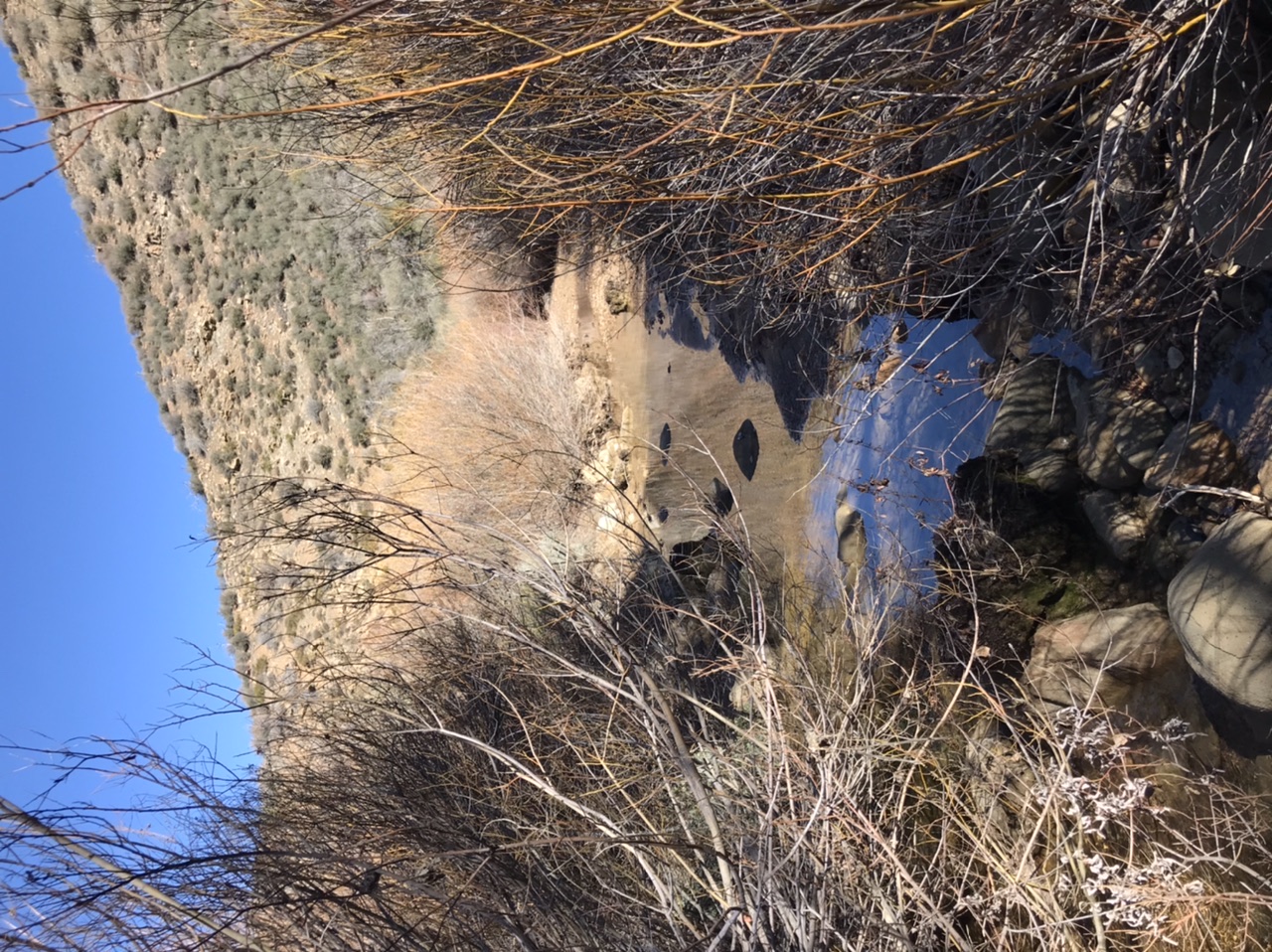
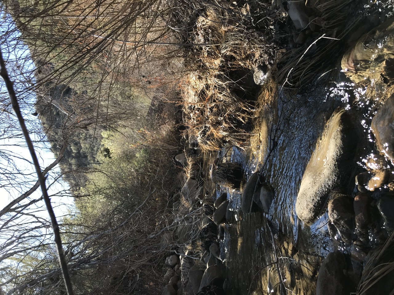
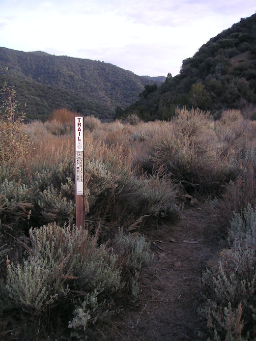
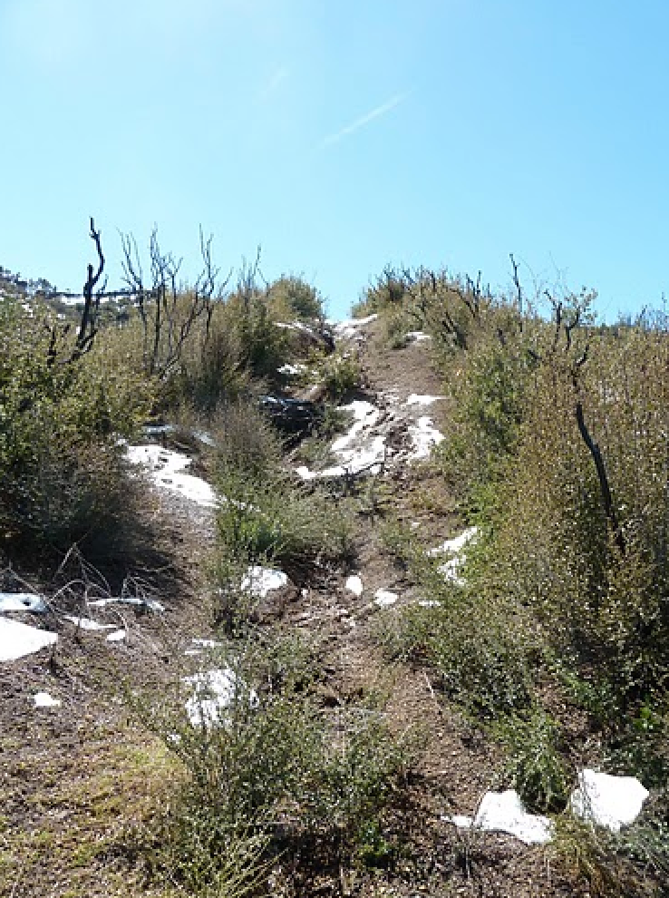
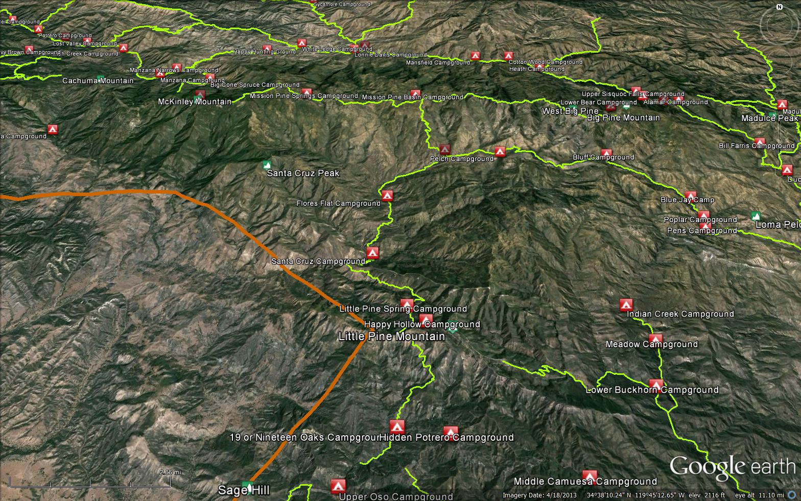
Santa Barbara Canyon heads south from the trailhead at the old Willow Flat Campground. The trailhead is marked by a turnout on the righthand side of the road next to a juniper tree. The trail starts there, crosses the creek and immediately enters the Dick Smith Wilderness. The trail meanders along a large sandy portion of the canyon but gradually gets narrower and narrower as you get deeper into the canyon. There are 34 creek crossings as you make your way up the canyon. Expect to see lots of bear signs and push your way through more than your share of flesh breaking California rose bushes. The canyon is mostly oak trees and is quite nice. Eventually you'll make your way to a final climb up to Madulce Camp called Heart Break Hill. This climb was named by an ex-Ranger of the SLRD named Dave Weaver. Heart Break Hill is a steep gullied climb of less than a mile but it will feel like twice that much. Once at the top of the hill, it is a short, gradual and beautiful descent to Madulce Camp.
Madulce - 7 miles from the trailhead


 Santa Barbara Canyon Trail Survey - 01-05-2025 - by Anonymous Surveyor
| Link: | Santa Barbara Canyon Trail |
| Date: | 01-05-2025 |
| Surveyor Name: | Anonymous Surveyor |
| Trail description: | Hiked from trailhead to picnic table at Chokecherry. Trail was easy to follow. Had a handful of ticks from just North of Chokecherry Canyon. Light water flowing on a about half of the crossings. |
| Mode of transport: | Hike |
| Trail condition: | Good shape and easy to follow |
Santa Barbara Canyon Trail Survey - 05-24-2024 - by Clancy| Link: | Santa Barbara Canyon Trail |
| Date: | 05-24-2024 |
| Surveyor Name: | Clancy |
| Trail description: | Generally pretty good by LPF backcountry standards these days. Some downed trees and occasional pushing through brush. Easy to follow for the most part. A little tricky at some of the stream crossings to find the trail again. There is a picnic table on the creek before Chokecherry Canyon and going up Heart Break Hill. |
| Mode of transport: | Hike |
| Trail condition: | Needs some work |
Santa Barbara Canyon Trail Survey - 11-24-2022 - by Charles| Link: | Santa Barbara Canyon Trail |
| Date: | 11-24-2022 |
| Surveyor Name: | Charles |
| Trail description: | The trail was in good shape for the most part. There were about 7 downed trees and the rosebush thorns were very overgrown, but the tread was still findable the whole way. Just a couple of crossings with water. Switchbacks in heartbreak hill would be amazing. |
| Mode of transport: | Hike |
| Trail condition: | Needs some work |
Santa Barbara Canyon Trail Survey - 04-30-2022 - by Mojo| Link: | Santa Barbara Canyon Trail |
| Date: | 04-30-2022 |
| Surveyor Name: | Mojo |
| Trail description: | Recent trail work makes this a pleasant and easy trail to follow as far as SB backcountry goes. Hiked from the trailhead to Madulce where I turned up towards the ridge. Lots of wildflowers and great examples of other local flora. First few crossings were dry but reliable water starting not far from the trailhead. Unbelievable amount of ticks in the mile stretch before Heartbreak Hill. They really like to hang out on the wild rosebush encroaching on the trail. Picked off a total of 106, glad I wore pants. Tickmageddon ended once I got a little up the hill and out of the creek bed. No downed trees or heavy chaparral. One crossing was ankle deep, feet stayed dry on all the rest. The rose grows in fast but thorns weren't too bad yet. Poison oak was present but unoppressive. Saw two fire rings on the side of the trail before reaching Madulce. But for the ticks this was a 10/10 section. |
| Mode of transport: | Hike |
| Trail condition: | Good shape and easy to follow |
Santa Barbara Canyon Trail Survey - 03-13-2022 - by Anonymous Surveyor| Link: | Santa Barbara Canyon Trail |
| Date: | 03-13-2022 |
| Surveyor Name: | Anonymous Surveyor |
| Trail description: | Many creek crossings and roses as indicated in the description. 3 camps/fire rings were observed along the trail. Water was flowing in the creek. Water was cleaner in the upper portion of the canyon and not Orange like in the lower portion. Went down heartbreak hill. Definitely a gully down the middle of it. Would not go out of my way to hike the judell-sb canyon loop again |
| Mode of transport: | Hike |
| Trail condition: | Needs some work |
| Images: | |
Santa Barbara Canyon Trail Survey - 02-17-2022 - by Los Padres Forest Association| Link: | Santa Barbara Canyon Trail |
| Date: | 02-17-2022 |
| Surveyor Name: | Los Padres Forest Association |
| Trail description: | The LPFA is working on a reroute of Heartbreak Hill and will be out along SB Cyn quite a bit over the coming months and years. The trail is in good shape at the moment and easy to follow. Some brush in spots but otherwise a wilderness freeway by LP standards. Water starts along the trail at third creek crossing and continues from there up to Heartbreak. Enjoy..... |
| Mode of transport: | Array |
| Trail condition: | Good shape and easy to follow |
Santa Barbara Canyon Trail Survey - 02-21-2021 - by Los Padres Forest Association| Link: | Santa Barbara Canyon Trail |
| Date: | 02-21-2021 |
| Surveyor Name: | Los Padres Forest Association |
| Trail description: | Trail was in good enough shape by LP Backcountry standards. Some brush once again encroaching on the trail in places and the occasional downed tree but overall in good shape. Heartbreak remains steep and rutted! Good water along most of the trail..... Enjoy. |
| Mode of transport: | Array |
| Trail condition: | Good shape and easy to follow |
Santa Barbara Canyon Trail Survey - 11-27-2021 - by Anonymous Surveyor| Link: | Santa Barbara Canyon Trail |
| Date: | 11-27-2021 |
| Surveyor Name: | Anonymous Surveyor |
| Trail description: | Very beautiful trail. Only a couple fallen trees and some overgrowth. Easy to follow. Rosebush was annoying. The creek had a couple different spots with flowing water but other than that it was completely dry. |
| Mode of transport: | Hike |
| Trail condition: | Good shape and easy to follow |
| Images: | |
Santa Barbara Canyon Trail Survey - 04-24-2021 - by Addison Jerlow| Link: | Santa Barbara Canyon Trail |
| Date: | 04-24-2021 |
| Surveyor Name: | Addison Jerlow |
| Trail description: | Clear and easy for the first few miles, intermittent flow/pools in the creek after 3ish miles (first flowing creek crossing has fastest moving water). Lots of roses from then on but not too sharp right now, trail still easy to follow. Heart Break Hill looking a little washed out/overgrown but easy to follow. |
| Mode of transport: | Hike |
| Trail condition: | Good shape and easy to follow |
Santa Barbara Canyon Trail Survey - 12-20-2020 - by Luna| Link: | Santa Barbara Canyon Trail |
| Date: | 12-20-2020 |
| Surveyor Name: | Luna |
| Trail description: | |
| Mode of transport: | Hike |
| Trail condition: | Needs some work |
| Condition details: | A few downed trees, and a lot of overgrown rose. Some sneaky poison oak hidden in the rose. |
Santa Barbara Canyon Trail Survey - 06-23-2020 - by John Doe | Link: | Santa Barbara Canyon Trail |
| Date: | 06-23-2020 |
| Surveyor Name: | John Doe |
| Trail description: | The first half or so of the trail is in great condition, gradually becoming more overgrown, with several downed trees and sections choked with ceanothus and rose thorns as you near Heartbreak Hill. Once the steep climb begins, the path widens and the  bushwhacking ends. There are a few crossings that are choked out with vegetation to the point where you have to stop and think about where the trail might be on the other side, but it is easy to follow overall. Water (of varying quality) present in most crossings, passable without getting your feet wet. |
| Mode of transport: | Hike |
| Trail condition: | Needs some work |
| Condition details: | Easy to follow w/ bushwhacking near upper creek crossings |
Santa Barbara Canyon Trail Survey - 05-15-2020 - by Antonio Calderon| Link: | Santa Barbara Canyon Trail |
| Date: | 05-15-2020 |
| Surveyor Name: | Antonio Calderon |
| Trail description: | Did a portion of the trail from willow flat to chokecherry canyon. The deeper you go in the canyon the brushier the creek crossings get. Bringing some shears next time to cut through some of the rougher sections. Creek was flowing good and getting our feet wet was unavoidable at some creek crossings. |
| Mode of transport: | Hike |
| Trail condition: | Good shape and easy to follow |
| Images: | |
Santa Barbara Canyon Trail Survey - 05-17-2019 - by Los Padres Forest Association| Link: | Santa Barbara Canyon Trail |
| Date: | 05-17-2019 |
| Surveyor Name: | Los Padres Forest Association |
| Trail description: | The LPFA led 8-days of trail work on SB Cyn between mid April and late May 2019. The focus of these projects was to brush the lower 1/2 mile of the trail and we also cleared 21 downed trees between the trailhead and the bottom of Heartbreak Hill. It's very depressing seeing how fast all the California Rose and willows at the crossings have come back after all the work we did on SB Cyn in 2017-2018. The trail was in near perfect shape in late 2017 and early 2018 and now in some spots it looks like we were never there. That's part of life working in the chaparral but it's also partly due to the Reyes Ranch gate now being closed during prime backpacking season. SB Cyn just isn't seeing the amount of users it once did and as a result the trail is becoming overgrown at a much faster rate. |
| Mode of transport: | Hike |
| Trail condition: | Needs some work |
| Condition details: | Water was available along the full extent of the SB Canyon Trail. |
Santa Barbara Canyon Trail Survey - 05-06-2019 - by Diane Soini| Link: | Santa Barbara Canyon Trail |
| Date: | 05-06-2019 |
| Surveyor Name: | Diane Soini |
| Trail description: | The trail was a lot of work to hike. There are a lot of fallen trees requiring constant negotiation, sometimes removing your pack to get under. The trail is brushy. Lots of ticks. Fortunately not much poison oak. The heartbreak hill section is more like footbreak hill for anybody going down. And the start of the trail at the top near Madulce Camp is faint. |
| Mode of transport: | Hike |
| Trail condition: | Needs some work |
| Condition details: | Trail is brushy with a lot of small fallen trees |
Santa Barbara Canyon Trail Survey - 04-09-2019 - by Los Padres Forest Association| Link: | Santa Barbara Canyon Trail |
| Date: | 04-09-2019 |
| Surveyor Name: | Los Padres Forest Association |
| Trail description: | LPFA trail report that there are "tons of down trees from Santa Barbara Cyn up to Madulce".  There will be a trail crew working SB Cyn later this month, we'll update when they get back. |
| Mode of transport: | Hike |
| Trail condition: | Needs some work |
Santa Barbara Canyon Trail Survey - 01-02-2019 - by Brad Anderson| Link: | Santa Barbara Canyon Trail |
| Date: | 01-02-2019 |
| Surveyor Name: | Brad Anderson |
| Trail description: | Approximately 10 1-2 ft diameter trees down between Santa Barbara canyon trailhead and madulce camp. There is a trickle for me spring about halfway to madulce camp. |
| Mode of transport: | Hike |
| Trail condition: | Good shape and easy to follow |
Santa Barbara Canyon Trail Survey - 08-25-2018 - by Andrew| Link: | Santa Barbara Canyon Trail |
| Date: | 08-25-2018 |
| Surveyor Name: | Andrew |
| Trail description: | Easy to follow trail however the second half of the trail will mostly have waist-high brush along the rest of the way until Heartbreak Hill. The California Rose Bushes were incredibly annoying. Trail was completely dry this time of year. A few large dead trees required a little bushwhacking to get around including one spot that unfortunately required cutting a switchback. |
| Mode of transport: | Hike |
| Trail condition: | Needs some work |
Santa Barbara Canyon Trail Survey - 05-15-2018 - by Valerie Norton| Link: | Santa Barbara Canyon Trail |
| Date: | 05-15-2018 |
| Surveyor Name: | Valerie Norton |
| Trail description: | There is water in the canyon from about 2 miles up until shortly before Heartbreak Hill. There is more water from Madulce Camp on up to until shortly before that one tree that had fallen along the trail. You know it? That's the last crossing, anyway. Water can be heard past that, but it would be really hard to get to. I guess we are calling that bit Madulce Trail anyway even though the signs clearly think it is more of Santa Barbara Canyon. Sure, there is a certain amount of sense to doing it this way... Anyway. I jumped over/walked around 9 trees, none of them very big but half of them annoyingly high. I followed the switchbacks on the first bit of the rut up Heartbreak Hill. I take it those are being left to return to the bushes? Oh, the roses. They all seem soft and not particularly grabby as they are still getting started. Or maybe I found the right pair of pants. I doubt it is the pants. A few of the leaves have galls on them, which was interesting to see. No one else out there, but it was a Tuesday. |
| Mode of transport: | Hike |
| Trail condition: | Good shape and easy to follow |
Santa Barbara Canyon Trail Survey - 03-19-2018 - by Los Padres Forest Association| Link: | Santa Barbara Canyon Trail |
| Date: | 03-19-2018 |
| Surveyor Name: | Los Padres Forest Association |
| Trail description: | The SB Cyn Trail is in FANTASTIC SHAPE, best shape its been in for many many years. All the work from the past two seasons is holding nice. It starts a little brushy for the first 1.5 miles but then opens up into a really lovely trail - best way to describe it. There are two larger crosscut trees down across the trail at 3.1 and 4.2 miles. Heartbreak Hill remains a sloshy rutted challenge but all the brush has been cleared along that section as well. Good time for SB Cyn - get it while the gettin is good.  The biggest bummer is that the gate remains closed at Reyes Ranch, which tacks on an additional 4 miles each way to your hike. You could ride it on a mountain bike but lets hope the gate gets opened again soon as the road is in good shape. |
| Mode of transport: | Hike |
| Trail condition: | Good shape and easy to follow |
| Images: | New trailhead sign. Lovely Still breaking hearts One of the best views out there Trail junction at Madulce Camp |
Santa Barbara Canyon Trail Survey - 05-07-2017 - by Los Padres Forest Association| Link: | Santa Barbara Canyon Trail |
| Date: | 05-07-2017 |
| Surveyor Name: | Los Padres Forest Association |
| Trail description: | LPFA trail project clearing a large downed oak from the trail: http://lpforest.org/santa-barbara-canyon-oak-tree-clearing/ |
| Mode of transport: | Hike |
| Trail condition: | Needs some work |
Santa Barbara Canyon Trail Survey - 04-30-2017 - by Abby Fitch| Link: | Santa Barbara Canyon Trail |
| Date: | 04-30-2017 |
| Surveyor Name: | Abby Fitch |
| Trail description: | The gate at Reyes Ranch is still closed, so plan for an extra 4 miles each way on this hike from the closed gate (we were lucky to run into forest manager Joe Dura, our knight in shining pickup truck, who gave us a lift back to the gate on our way back out and saved us the walking from the trailhead). Â Trail is in good shape and easy to follow, except to note that it iS getting a bit brushy in spots - definitely wear your hiking pants- and that at the first water crossing the trail picks up to the left on the opposite bank - we missed that on the way out and walked downstream for almost a mile. Â Water everywhere - prepare to get wet on the numerous creek crossings - and the Maldulce campsite is in beautiful shape. Â Saw a rattlesnake but no bears. Â Have a great time! |
| Mode of transport: | Hike |
| Trail condition: | Good shape and easy to follow |
| Images: | Pine canyon Full bloom Stunning Water everywhere Green at last |
Santa Barbara Canyon Trail Survey - 04-21-2017 - by Mike Maki| Link: | Santa Barbara Canyon Trail |
| Date: | 04-21-2017 |
| Surveyor Name: | Mike Maki |
| Trail description: | I second what Los Padres Forest Association reported from 3/18/2017. Still good water all the way to Heartbreak Hill. Couple of easy crossing trees down and a little brusy in some areas. Definitely a "Yellow" Bryan Conant map trail. Able to keep feet dry at all crossings. Saw two other hikers that day on top of Heartbreak Hill when I was about half way up. Made it to Lower Bear Camp that afternoon. First of a four day Condor Trail section hike to Manzana Schoolhouse and out at NIRA. Pics here if interested. |
| Mode of transport: | Hike |
| Trail condition: | Good shape and easy to follow |
| Images: | Wayside at beginning of trail section after 3 mile hike in up road. Trail on the lower section. Good water The "in the creek" section. Able to keep dry. VIew north down the canyon from top of Heartbreak Hill |
Santa Barbara Canyon Trail Survey - 03-18-2017 - by Los Padres Forest Association| Link: | Santa Barbara Canyon Trail |
| Date: | 03-18-2017 |
| Surveyor Name: | Los Padres Forest Association |
| Trail description: | Santa Barbara Canyon Trail is in really good shape by Dick Smith standards. Â Someone has gone through and cut out around 30 trees (all but two) along the trail. Â There remains brushy sections, that one section that literally goes through the creek and some severe ruts, but there is no trouble following the trail. Â Heartbreak Hill remains a steep rutted slog but is still open after last years May Working Vacation trail work. Â Water along the entire length of the trail. Â The gate is still locked at Reyes Ranch, which does add an extra 4miles of hiking/riding the road in order to get to the trailhead. Â Enjoy! |
| Mode of transport: | Hike |
| Trail condition: | Good shape and easy to follow |
| Images: | Signs of recent tree removal along the entire stretch of SB Cyn Trail. One of two remaining downed trees along the trail (34.7416, -119.5668) Dick Smith rose sections, ouch! Heartbreak Hill, looking better than normal! Views down to Madulce Camp and Madulce Peak (no snow) |
Santa Barbara Canyon Trail Survey - 02-12-2017 - by Kevin Pietrzak| Link: | Santa Barbara Canyon Trail |
| Date: | 02-12-2017 |
| Surveyor Name: | Kevin Pietrzak |
| Trail description: | Water water everywhere! We had to wade a number of the creek crossings as the creek was too high for rock hopping. The trail was in good shape and easy to follow. The roses haven't taken over... yet. Thanks to all the folks who have been working on the trail! There were about 10 trees down between the TH and Madulce. A couple of trees were down at creek crossings which made for awkward fording. Next time I'm bringing a saw. Manzanita and silk tassel were in bloom but otherwise a little early for spring. It was very nice to see all the green in the hills and water in the creeks I was taken aback by the abundance of trash along the trail, almost entirely beverage containers (water bottles, beer/soda cans, gatorade, pedialyte, etc.) My girlfriend and I packed out all we could find. In total we brought back 83 plastic bottles, 34 aluminum cans, a glass bottle and a small trash bag of non-recyclables. Both of our packs doubled in volume with all the trash. While I'm glad people are taking care of themselves and staying hydrated I wish they would show the same respect for the Los Padres and their fellow hikers. |
| Mode of transport: | Hike |
| Trail condition: | Good shape and easy to follow |
Santa Barbara Canyon Trail Survey - 05-30-2016 - by Los Padres Forest Association| Link: | Santa Barbara Canyon Trail |
| Date: | 05-30-2016 |
| Surveyor Name: | Los Padres Forest Association |
| Trail description: | The LPFA led two trail projects along Santa Barbara Canyon Trail in 2016. Â The trail should be very followable from start to finish but expect sections of brush-pushing and having to fight back the California Rose. Â All in all, it should be in good shape and great shape by Dick Smith measures. Â Go and get some..... More information and photos can be found here: https://www.facebook.com/LosPadresForestAssociation/posts/617391001719161 |
| Mode of transport: | Array |
| Trail condition: | Needs some work |
Santa Barbara Canyon Trail Survey - 12-18-2015 - by Los Padres Forest Association| Link: | Santa Barbara Canyon Trail |
| Date: | 12-18-2015 |
| Surveyor Name: | Los Padres Forest Association |
| Trail description: | See report below: |
| Mode of transport: | Hike |
| Trail condition: | Needs some work |
Santa Barbara Canyon Trail Survey - 05-01-2015 - by Hike Los Padres| Link: | Santa Barbara Canyon Trail |
| Date: | 05-01-2015 |
| Surveyor Name: | Hike Los Padres |
| Trail description: | Mount Pinos Volunteer Wilderness Rangers patrolled the SB Cyn Trail and removed a few downed trees before Heart Break Hill. |
| Mode of transport: | Array |
| Trail condition: | Needs some work |
| Images: | Before After |
Santa Barbara Canyon Trail Survey - 03-29-2015 - by Hike Los Padres| Link: | Santa Barbara Canyon Trail | ||
| Date: | 03-29-2015 | ||
| Surveyor Name: | Hike Los Padres | ||
| Trail description: | UTMC and Wilderness Corps led a trail project up SB Cyn and removed nearly 60 trees from the trailhead up to the base of Heartbreak Hill.  There was one large downed oak that was not cleared at the base of  of the HBHill. Link to Wilderness Corps photos:
| ||
| Mode of transport: | Array | ||
| Trail condition: | Needs some work |
Santa Barbara Canyon Trail Survey - 02-28-2015 - by Hike Los Padres| Link: | Santa Barbara Canyon Trail |
| Date: | 02-28-2015 |
| Surveyor Name: | Hike Los Padres |
| Trail description: | Wilderness Corp and United Trail Maintainers of California led a trail project to log fallen trees from the SB Canyon Trail. Â They counted 25 trees and were able to remove 11 of them from the trail corridor. Â Further projects are planned to remove the remaining downed trees. |
| Mode of transport: | Array |
| Trail condition: | Needs some work |
Santa Barbara Canyon Trail Survey - 04-25-2015 - by Los Padres Forest Association| Link: | Santa Barbara Canyon Trail |
| Date: | 04-25-2015 |
| Surveyor Name: | Los Padres Forest Association |
| Trail description: | • Most of the crossings along SB Canyon had water. |
| Mode of transport: | Hike |
| Trail condition: | Needs some work |
Santa Barbara Canyon Trail Survey - 06-21-2014 - by Los Padres Forest Association| Link: | Santa Barbara Canyon Trail |
| Date: | 06-21-2014 |
| Surveyor Name: | Los Padres Forest Association |
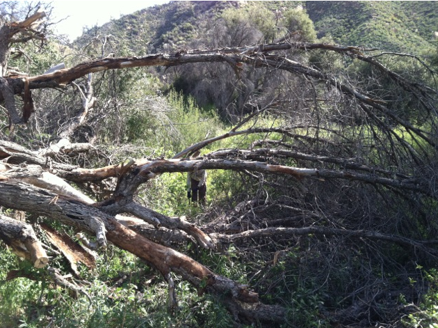
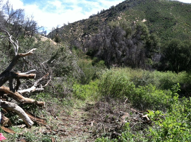
| Trail description: | Approximately 4 downed trees. The rose was awful. Worst time along this trail, time for a clearing. |
| Mode of transport: | Hike |
| Trail condition: | Needs some work |
| Condition details: | Overhead California rose was gnarly |
| Number of trees down: | 4 |
 Survey / Report Form - Please click this box to open the form.