 Use Marker Groups
 Wolf 2002
Piru 2003
Day 2006
Zaca 2007
Gap 2008
La Brea 2009

| Date | Surveyor | Water Report |
| 10-20-2023 | Connor Byrne | Flowing |
| 11-11-2018 | Anonymous Surveyor | Dry |
| 10-27-2018 | Antonio Calderon | Flowing |
| 08-25-2018 | Andrew Carter | Flowing |
| 09-19-2017 | NickD | Trickle |
| 05-16-2017 | Kara Hooper | Flowing |
| 02-25-2017 | Anonymous Surveyor | Flowing |
| 07-09-2016 | Anonymous Surveyor | Flowing |
| 06-24-2016 | Anonymous Surveyor | Flowing |
| 02-13-2016 | Ron Varenchik | Flowing |
| 05-18-2015 | Kara Hooper | Flowing |
| 09-07-2014 | Los Padres Forest Association | Flowing |
This camp is located on the southeast side of Alder Creek under large Coast Live oak trees on a low stream terrace. The 1968 floods washed out the short side trail to the camp from the Capper Sespe River Trail 20W30 so one must walk down the bed of Alder Creek. A short distance down stream from the camp Alder Creek plunges down a steep narrows on its way to the Sespe River. It is possible to climb down to the river through the narrows if you keep at the base of the left wall.
At one time there was a fire ring. Water is available from Alder Creek down stream from the camp.
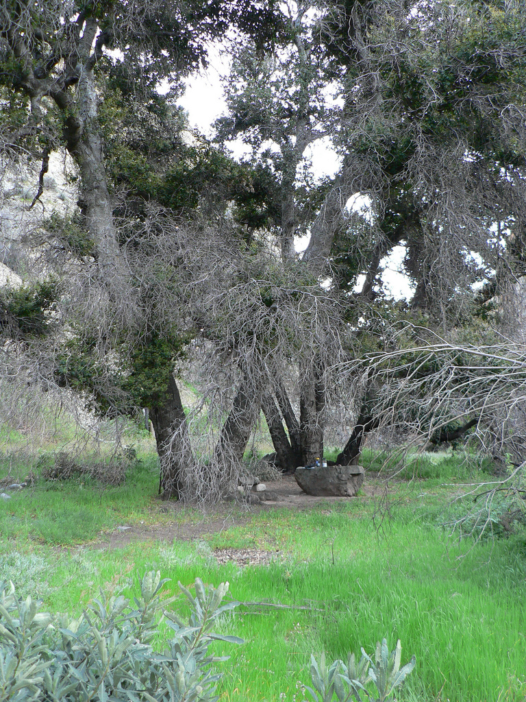
Shady Camp is located a short distance off the Alder Creek Trail above Alder Gorge in the Sespe Wilderness. Shady is set under a large oak tree and is home to a unique flat rock that acts more like a table for campers. Shady is along the Condor Trail.
Special Features: This small, serene camp is located just above the Sespe Condor Sanctuary. Firearms are prohibited.


 Shady Camp Survey - 10-20-2023 - by Connor Byrne
| Link: | Shady Camp |
| Date: | 10-20-2023 |
| Surveyor Name: | Connor Byrne |
| Camp Description: | |
| Water Source: | Flowing |
| Water Source Details: | |
| Weather Conditions: |
Shady Camp Survey - 11-11-2018 - by Anonymous Surveyor| Link: | Shady Camp |
| Date: | 11-11-2018 |
| Surveyor Name: | Anonymous Surveyor |
| Camp Description: | I'm looking for anyone who wants to pack into this camp. I'm looking at next May. Please contact me at lakesidepark@hotmail.com if anyone is interested. Thank |
| Water Source: | Dry |
| Water Source Details: | |
| Weather Conditions: |
Shady Camp Survey - 10-27-2018 - by Antonio Calderon| Link: | Shady Camp |
| Date: | 10-27-2018 |
| Surveyor Name: | Antonio Calderon |
| Camp Description: | Beautiful camp with nice size fire ring and huge flat boulder to use as a table. The camp is huddled  by a couple of oak trees that provides lots of shade. We stayed over night and the weather was perfect. |
| Water Source: | Flowing |
| Water Source Details: | Slow flow |
| Weather Conditions: | Sunny and Hot, High 80s |
| Images: | |
Shady Camp Survey - 08-25-2018 - by Andrew Carter| Link: | Shady Camp |
| Date: | 08-25-2018 |
| Surveyor Name: | Andrew Carter |
| Camp Description: | Hiked in from Dough Flats Trailhead with my son. About 7.5 miles. Spent night. No other obvious water until this point. Deepest pool was 1 feet. Enough to take cooling cooking pot shower. Water has high mineral content. Not very tasty. |
| Water Source: | Flowing |
| Water Source Details: | Water flowing above ground for perhaps 50 yards |
| Weather Conditions: | Hot during the day, chilli at night. Terrible air quality. |
Shady Camp Survey - 09-19-2017 - by NickD| Link: | Shady Camp |
| Date: | 09-19-2017 |
| Surveyor Name: | NickD |
| Camp Description: | Trail tough to follow between Alder Creek Camp and Shady Camp. It zig-zags numerous times and it's easy to miss sections. Shady camp itself is nice, situated between to huge oak trees for shade. There's a big cliff to the west though so it does lose daylight early, and as another poster pointed out, it gets WINDY! Water had dwindled down to a trickle just about 20yards long. Under current conditions I'd guess it's gone in a month |
| Water Source: | Trickle |
| Water Source Details: | |
| Weather Conditions: | 80's |
Shady Camp Survey - 05-16-2017 - by Kara Hooper| Link: | Shady Camp |
| Date: | 05-16-2017 |
| Surveyor Name: | Kara Hooper |
| Camp Description: | It was wonderful to be back at Shady Camp and to see all of the water! Wow! The waterfall, located in the canyon just down from camp, was roaring and three times the size it was a year ago. Alder Creek itself had plenty of water. We packed out an entire tent that had been left behind as well as some old tin cans. Remaining at the camp is a large, green tarp, which is actually really helpful to use and is in good shape. There is also a sleeping pad there which is defunct. Shady Camp is a lovely spot with a wonderful flat rock and a spacious, well constructed fire ring. This is a little slice of paradise. It can get really windy at times, and cool, as it is at the mouth of a canyon that leads Alder Creek into the Sespe. |
| Water Source: | Flowing |
| Water Source Details: | nice steady flow |
| Weather Conditions: |
Shady Camp Survey - 02-25-2017 - by Anonymous Surveyor| Link: | Shady Camp |
| Date: | 02-25-2017 |
| Surveyor Name: | Anonymous Surveyor |
| Camp Description: | Made an unplanned stay at this campsite because we were not able to follow the sespe creek trail down into the sespe drainage due to washout. Â The trash noted be a previous visitor is still at the site, in addition to other trash that has since been left. Â We picked up the small trash scattered across the ground, but did not have room to carry out the large items |
| Water Source: | Flowing |
| Water Source Details: | |
| Weather Conditions: | |
| Images: | Pile of trash left by previous campers |
Shady Camp Survey - 07-09-2016 - by Anonymous Surveyor| Link: | Shady Camp |
| Date: | 07-09-2016 |
| Surveyor Name: | Anonymous Surveyor |
| Camp Description: | |
| Water Source: | Flowing |
| Water Source Details: | |
| Weather Conditions: | Hot and dry |
Shady Camp Survey - 06-24-2016 - by Anonymous Surveyor| Link: | Shady Camp |
| Date: | 06-24-2016 |
| Surveyor Name: | Anonymous Surveyor |
| Camp Description: | Trash at camp (thermarest, tarp, plastic drop cloth, plastic bag with toiletries). Removed plastic drop cloth. |
| Water Source: | Flowing |
| Water Source Details: | |
| Weather Conditions: | 95F+ |
| Images: | Alder Creek - South of Camp |
Shady Camp Survey - 02-13-2016 - by Ron Varenchik | Link: | Shady Camp |
| Date: | 02-13-2016 |
| Surveyor Name: | Ron Varenchik |
| Camp Description: | |
| Water Source: | Flowing |
| Water Source Details: | Lots of waterfalls just down the creek! |
| Weather Conditions: |
Shady Camp Survey - 05-18-2015 - by Kara Hooper| Link: | Shady Camp |
| Date: | 05-18-2015 |
| Surveyor Name: | Kara Hooper |
| Camp Description: | This is a beautiful camp, nestled underneath some old, mature oak trees. A huge boulder names a great table, and there is a good fire ring and sitting logs. Campers can easily access the canyon and the waterfall just below the camp. Finding the camp can be a little bit tricky, as it is actually downstream and to the left side of the river, while the topo map for Devil's Heart Peak places it on the right side of the river. |
| Water Source: | Flowing |
| Water Source Details: | The water is plentiful here. |
| Weather Conditions: |
Shady Camp Survey - 09-07-2014 - by Los Padres Forest Association| Link: | Shady Camp |
| Date: | 09-07-2014 |
| Surveyor Name: | Los Padres Forest Association |
| Camp Description: | |
| Water Source: | Flowing |
| Water Source Details: | |
| Weather Conditions: |
 Survey / Report Form