 Use Marker Groups
 Wolf 2002
Piru 2003
Day 2006
Zaca 2007
Gap 2008
La Brea 2009

The trailhead is near Mutau Flat, located in the Mt. Pinos Ranger District. After a rolling three miles, the trail drops steeply into Hot Springs Canyon. There is no water and little shade along the first seven miles of the trail. After 8.5 mile from the trailhead, a side trail leads into Hot Springs Creek. At .6 miles further, there is another camp and .4 mile further is the Sespe River Trail (20W13). Prior to the June 1992 wilderness legislation, this was a popular motorcycle trail. It is now open only to horseback riders and hikers.
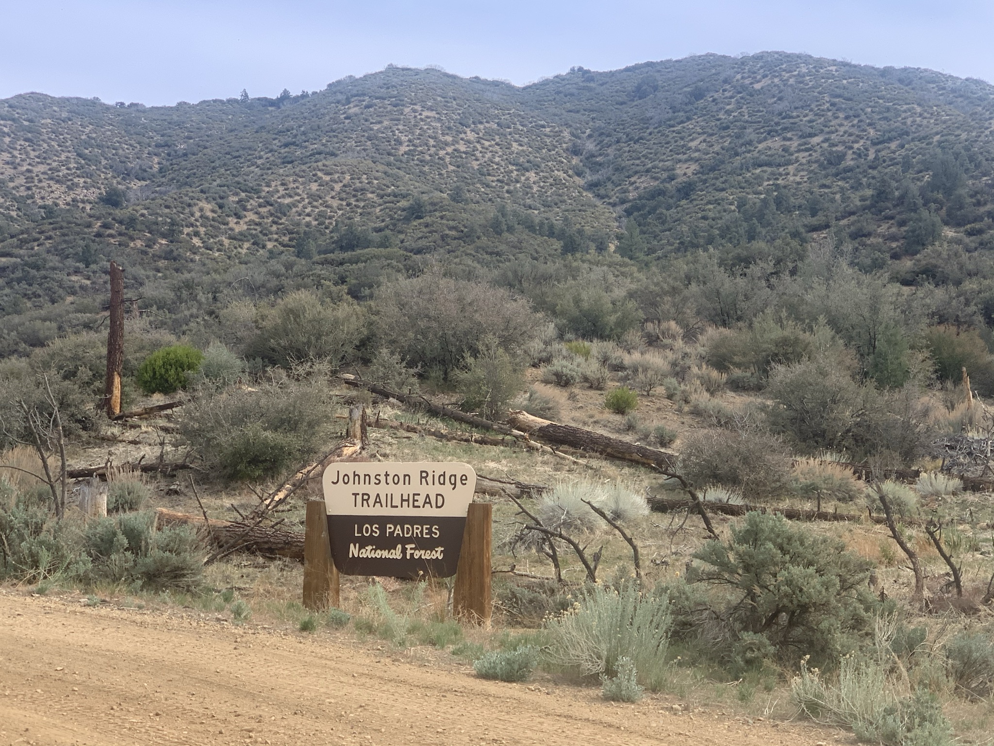


 Johnston Ridge Trail Survey - 04-30-2025 - by Tom Fritz
| Link: | Johnston Ridge Trail |
| Date: | 04-30-2025 |
| Surveyor Name: | Tom Fritz |
| Trail description: | Hiked this in its entirety from North to South, from the intersection with the StoneHouse trail, down to the intersection with the trail to Shady camp. The Mutau Creek had good flow. No water at the intersection where the trail to Little Mutau splits off. The unnamed creek coming out of the watershed/canyon that's to your right as you're heading down-ridge was running clear and cold. The trail wasn't too bad, but needs some work. It's getting tight in some places. Permethrin was the word of the day. Once you've left the split to Little Mutau, where the big-iron-motorbike trap is, the trail to the top of the first ridge has a shrub or two growing up out of the tread causing some work-arounds in the trail. Once you've hit the top of this first ridge (1.2 mi from the SH/JR intersection), the scrub starts to close-in. In .3 mile, the trail takes its first switchback off the old firebreak you notice you've started hiking on. Looking down this switchback, the washed out trail and the manzanita overgrowth at that point forced my hand to continue down the old firebreak. In another .1 mi, the trail switches back to the right (off the firebreak, and down into a small meadowy-pocket). This is the area where those weird oval-shaped, "salami-cut," trail signs are located. That portion of the trail has been slowly filling with brush over the past several years. Looked like a thrash – so I kept to the fire-break for another .1mi, and then dropped down to rejoin the trail where one can clearly see it heading south, appearing as an old road. The trail is in fairly good shape until you reach that portion where the trail is on the southwest-facing portion of the ridge (where you've lost sight of peneplains to the east). That's where the brush starts to squeeze-in again. Judicial lopping in places has helped (and is gratefully appreciated!! – Thank you!!), but it'll soon need more attention. Once I reached the bottom, I had the entire hot springs area to myself. Enjoyed a soak and continued on my way down-canyon. Poison oak is more than abundant in the usual spots heading down to the creek-crossing before Sespe camp, and the rest of the way to the metal "Trail 20W12" sign. Blue-bird skies with puffy clouds made for a beautiful hike. |
| Mode of transport: | Hike |
| Trail condition: | Needs some work |
Johnston Ridge Trail Survey - 12-23-2024 - by Brian Clark| Link: | Johnston Ridge Trail |
| Date: | 12-23-2024 |
| Surveyor Name: | Brian Clark |
| Trail description: | So happy to see this trailhead open for the Christmas break! Trail is in good condition but a bit overgrown. Water is flowing at Matu Creek crossing and at the end of the trail at the bottom of the canyon. I stashed some extra water that I did not need in two places along the trail if anyone is in need, at 2 miles and 5 miles starting from the bottom of the canyon. They should both be obvious. One was opened (1 L in a gallon jug) and the other (1.5 L) is unopened. This hike can be really difficult if its not nice and cool out. So, be careful and bring extra water! |
| Mode of transport: | Hike |
| Trail condition: | Needs some work |
Johnston Ridge Trail Survey - 11-13-2021 - by Marcus Imes| Link: | Johnston Ridge Trail |
| Date: | 11-13-2021 |
| Surveyor Name: | Marcus Imes |
| Trail description: | The road from Fishbowls trailhead to Johnston TH has 1 water
crossing even during drought, but was only about 8" deep. If it rained
recently this may be up to a foot or 2 deep and may require a high
clearance vehicle to access the trailhead. You could also park at
Fishbowls but that adds a few miles to the hike. I hear they also close
the access gate when it snows, but have not seen this personally. This
hike is HOT. Prepare for heat and exposure. Even in mid November it was
still close to 90 in the sun. I always hike with a solar umbrella and I
highly recommend it on this hike. You'd be cray to do this hike anytime
in the hot season without an umbrella (and i would not recommend this
hike when its hot under any conditions). Do
not expect any water along the hike. You pass a couple dry rivers, but
they only flow in the wet season after adequate soaking rains. On the
way in, even in the heat I only carried 2L water, and drank almost 1L at
the car before setting off. Since I got a late start I did not need it
all, as the sub goes behind the mountains a couple hours before sunset
and it cools off nicely. In the hot spring
valley, right now the only water source is the hotspring itself. During
wetter times there is a cold spring at the lower camp near the oaks on
the west side of the valley. That has the best water when its flowing. I
drank the hot spring water for 2 days. It tasted ok (I use a carbon
filter in addition to particulate). Not great, but it works. There were the usual bighorn sheep near the top of the valley in the morning. The
hike out is Brutal. 4000ft gain in 4 miles. Fully exposed. Carry lots
of water. I carried 2L water just to soak myself with as I climbed and
this plus my solar umbrella kept me adequately thermally regulated even
in the mid-day sun. I'd say get an early start on the hike out, but then
you miss the sheep which is half the reason to come to Sespe. I did not hike down to Sespe creek to see if there was water there. PLEASE
RESPECT FIRE BANS and TREAT EVERY FIRE WITH THE SAME RESPECT AS A
LOADED FIREARM. I had to tongue lash a group for violating fire ban, not
having a bucket of water ready, and leaving the fire unattended for a
couple minutes as it sparked in the direction of the dead palms. They
did not comprehend the severity of the situation. 1 spark finds fuel and
Thomas Fire version 2 is unleashed in a moment. If you have a fire, do
it only when allowed and treat it as if you are trying to contain a
monster, because you are!!! I encourage
everyone to call out poor behavior (fire, litter, poop, LNT) in the back
country as rangers are sparse. I had to hike out over a pound of litter
from trashy people. Dont be trashy. Stay Classy Los Padres peps |
| Mode of transport: | Hike |
| Trail condition: | Good shape and easy to follow |
| Images: | |
Johnston Ridge Trail Survey - 05-01-2021 - by Christopher P. Lord| Link: | Johnston Ridge Trail |
| Date: | 05-01-2021 |
| Surveyor Name: | Christopher P. Lord |
| Trail description: | Wandered about the Johnston Ridge area a bit today with the family. Didn't go to far beyond the wilderness boundary. Couple 13 inch downed trees shortly before dropping in on the Stonehouse junction. 34° 38.321' -119° 02.606' Pictures attached. |
| Mode of transport: | Hike |
| Trail condition: | Needs some work |
| Images: | |
Johnston Ridge Trail Survey - 04-18-2021 - by Tom Fritz| Link: | Johnston Ridge Trail |
| Date: | 04-18-2021 |
| Surveyor Name: | Tom Fritz |
| Trail description: | Started at bottom(Sespe Hot Springs area) and went up to Mutau Creek. Tanked up at the small creek coming in from the west at the bottom of the Johnston Ridge Trail where all the large campsites are. The water was flowing and is always cold and tastes great. The bottom mile of the Ridge Trail appears to have been brushed recently, as it wasn't too overgrown. The rest of the trail to the top was pretty straightforward. I suggest permethrin on your clothes as the ticks are always numerous on this trail. Up at the top, when you get into the Mutau Flat area, pay attention to the trail. This portion needs to be brushed and the trail reestablished. It can be tricky if you haven't been over the route before. The switchbacks as you proceed to the top of the ridge, right before you get to the saddle and drop into the Mutau Creek canyon, are starting to become a bushwhack. |
| Mode of transport: | Hike |
| Trail condition: | Needs some work |
| Condition details: | Needs brushing/clearing on the section from the Mutua Flat area to Mutau creek |
Johnston Ridge Trail Survey - 06-13-2020 - by Anonymous Surveyor| Link: | Johnston Ridge Trail |
| Date: | 06-13-2020 |
| Surveyor Name: | Anonymous Surveyor |
| Trail description: |
Trail was in mostly
good condition, except a few miles in around Mutau Flat, I got a
little lost, trail there has several branches that are not always
well marked. Going down the steep incline on the Johnston Ridge,
the trail is easy to follow, but brushy in places. You can see lots
of work went in fixing or supporting the trail in many locations.
Going uphill along the trail, I carried about a gallon of water and
drank it all before I was able to refill at Mutau Creek. Good amount of water in Hot Springs Creek. Side canyon on the west of Johnston Ridge trail is the good source of drinking water. |
| Mode of transport: | Hike |
| Trail condition: | Good shape and easy to follow |
Johnston Ridge Trail Survey - 11-23-2019 - by Robin Hutchinson| Link: | Johnston Ridge Trail |
| Date: | 11-23-2019 |
| Surveyor Name: | Robin Hutchinson |
| Trail description: | |
| Mode of transport: | Hike |
| Trail condition: | Needs some work |
| Condition details: | thick vegetation in some sections |
Johnston Ridge Trail Survey - 05-19-2019 - by MightyM| Link: | Johnston Ridge Trail |
| Date: | 05-19-2019 |
| Surveyor Name: | MightyM |
| Trail description: | From Sespe Hot Springs to Johnson Ridge TH - Very overgrown in spots, esp at lower end (near hot springs). Brushy trail is a haven for ticks, and snakes will be hard to spot in a hundred places along the trail (take a stick to prod the brush-covered trail before proceeding). Trail is not hard to follow. A few narrow spots, but nothing unpassable.  |
| Mode of transport: | Hike |
| Trail condition: | Needs some work |
| Condition details: | Brushy |
Johnston Ridge Trail Survey - 05-11-2019 - by Diane Soini| Link: | Johnston Ridge Trail |
| Date: | 05-11-2019 |
| Surveyor Name: | Diane Soini |
| Trail description: | I hiked the Johnston Ridge trail from the fancy trailhead parking and horse staging area in the middle of nowhere to the junction with the Little Mutau Trail. The trail was in excellent condition. There may have been a little bit of brushiness. There may have been a log over the trail near Mutau Flat, but I cannot remember now. There was nothing of any significance to impede your progress. |
| Mode of transport: | Hike |
| Trail condition: | Good shape and easy to follow |
Johnston Ridge Trail Survey - 08-19-2017 - by Dillon| Link: | Johnston Ridge Trail |
| Date: | 08-19-2017 |
| Surveyor Name: | Dillon |
| Trail description: | Trail was easy to follow, although somewhat overgrown in some areas with grasses and shrubs. Didn't need to do any real bushwhacking but snakes were a worry and did see one. The hot springs are definitely flowing but the creek on the other side was dry. This was the first overnight for my cousin and I and we weren't sure about the safety of drinking from hot springs due to sulfur, arsenic, etc. but we had packed in two gallons each which was good enough, although a little more would've been more comfortable. Tried to follow the creek downstream but the trail was far too overgrown for us in shorts without a machete. Going up towards the source was also overgrown with waist high grasses but we just crossed the creek and followed it up off trail instead. The downhill was pretty brutal on the knees and the uphill was definitely a good challenge, but the hike was definitely fun. Would recommend doing it in cooler weather when the other creek is flowing with some nice cool water. |
| Mode of transport: | Hike |
| Trail condition: | Good shape and easy to follow |
Johnston Ridge Trail Survey - 08-05-2017 - by Mysol| Link: | Johnston Ridge Trail |
| Date: | 08-05-2017 |
| Surveyor Name: | Mysol |
| Trail description: | The trail is easy to follow. We left at 2am and arrived to the Palm campsite by 4:30am we didn't need breaks on the way in since its fairly easy. The weather was warm even at night with a breeze. Hot springs are flowing perfectly but the cold steam near the trail head up to Johnston ridge trail head is low and ugly so I would recommend bring plenty of water. |
| Mode of transport: | Array |
| Trail condition: | Good shape and easy to follow |
| Images: | Hot spring near Palms camp view down the hot spring seen deer enjoying paradise |
Johnston Ridge Trail Survey - 06-09-2017 - by Tenderfoot| Link: | Johnston Ridge Trail |
| Date: | 06-09-2017 |
| Surveyor Name: | Tenderfoot |
| Trail description: | The trail was easy to follow with a few branches on the way back that required noting. From the hotsprings back is a steep climb so prepare yourself. The hot spring was flowing a lot and cold water in the creek to the north. It took us 5 hours in and 6 back but I am slow. Saw a rattlesnake headng over to the palm tree campsite so pay attention. |
| Mode of transport: | Hike |
| Trail condition: | Good shape and easy to follow |
Johnston Ridge Trail Survey - 05-17-2017 - by Anonymous Surveyor| Link: | Johnston Ridge Trail |
| Date: | 05-17-2017 |
| Surveyor Name: | Anonymous Surveyor |
| Trail description: | As usual hot and dry, but the trail was wide enough all the way down. |
| Mode of transport: | Hike |
| Trail condition: | Good shape and easy to follow |
Johnston Ridge Trail Survey - 09-17-2016 - by Oh Three| Link: | Johnston Ridge Trail |
| Date: | 09-17-2016 |
| Surveyor Name: | Oh Three |
| Trail description: | I did Johnson Ridge, from trailhead to Hot Springs and back, Sept 17-18, 2016. It's cleared of brush and easy, well, *easy* except for two things: It's confusing as you cross the Stonehouse trail valley. There's too many trails, cattle tracks, roads, fences, etc. Just aim to keep the same compass direction crossing that little valley as you came into it. Yes, like Shaddus Maximus said, go left on 1st choice, but when you come up out of the creek, then you take the right path. The other thing that is not *that* easy, is coming back uphill out of the Hot Springs. Whoa! Most of your elevation gain is in 1st couple miles. It's a south facing ridge, and you can bake your brains out. But anyone who hikes Los Padres National Forest knows about that! I strongly suggest hitting the trail before the sun. After 2-3 miles of nonstop climbing, it's basically level back to trailhead, maybe a couple hundred up and down. I last hiked Johnson Ridge in its last year as a motorcycle trail, 1994? God bless Bill Clinton for locking up Sespe and a lot of other land as Wilderness. Back then Johnson Ridge was an old car road, seriously rutted out by the dirt bikes. Now it's a nice trail, with just the right amount of switch backs. Little or no erosion. Excellent job NF rangers! Is there a volunteer group that puts in work? There must be. God bless them! Last time I hiked it, and this time, -- nobody else on the trail. That's wilderness! |
| Mode of transport: | Hike |
| Trail condition: | Good shape and easy to follow |
| Images: | Picture of little me as a shadow on a big uphill. Grinding! |
Johnston Ridge Trail Survey - 03-29-2016 - by Shaddus Maximus/Los Padres Forest Association| Link: | Johnston Ridge Trail |
| Date: | 03-29-2016 |
| Surveyor Name: | Shaddus Maximus/Los Padres Forest Association |
| Trail description: | This trail is an excellent shape. There is one confusing moment, however: When dropping south down from the trailhead, you cross the dirt road running east/west to Mutau Flat. On the other side of the road, there appears to be two ways to go (left of right) and there is no trail sign posted. Stay to the left. The trail will quickly become apparent again as you cross the sandy wash here. |
| Mode of transport: | Hike |
| Trail condition: | Good shape and easy to follow |
Johnston Ridge Trail Survey - 05-09-2015 - by Nico| Link: | Johnston Ridge Trail |
| Date: | 05-09-2015 |
| Surveyor Name: | Nico |
| Trail description: | Hiked the trail from the Sespe River up to the Hot Springs. Â Plenty of hot water pouring into the canyon from the various springs. Â Poplar Creek was dry and only a tiny trickle of water was running in the unnamed canyon just west of Johnston Ridge. Â I did not check Coldwater Creek. Lots of people milling about the Hot Springs now with Grade Valley Rd open. Â |
| Mode of transport: | Hike |
| Trail condition: | Good shape and easy to follow |
Johnston Ridge Trail Survey - 03-12-2015 - by Los Padres Forest Association| Link: | Johnston Ridge Trail |
| Date: | 03-12-2015 |
| Surveyor Name: | Los Padres Forest Association |
| Trail description: | We got a report today from a backpacker who hiked the lower Johnston Ridge Trail from Sespe up to the Hot Spring. Â There is good water flowing throughout the canyon and even cold water within the two creeks that feed into the hot springs above and below the spring. Â Great time to get out! Â Trail was in good shape. |
| Mode of transport: | Hike |
| Trail condition: | Good shape and easy to follow |
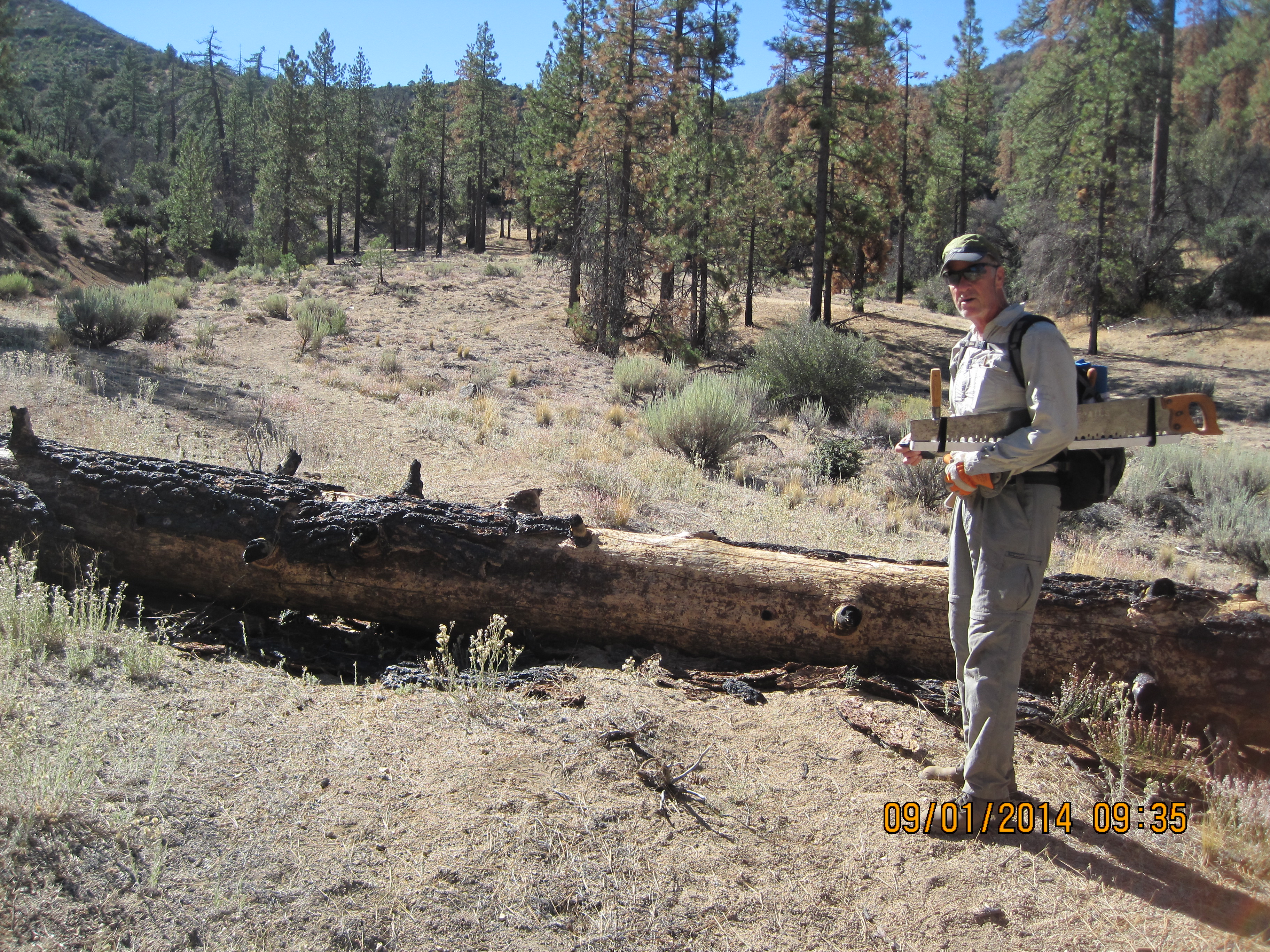
Johnston Ridge Trail Survey - 09-01-2014 - by Mark| Link: | Johnston Ridge Trail |
| Date: | 09-01-2014 |
| Surveyor Name: | Mark |
| Trail description: | Started trail from Johnston Ridge Trailhead; went approx 3+ miles to Ojai Ranger District Boundary. Â 2 trees down, but cleared several others. Â No water in Mutau Creek. |
| Mode of transport: | Hike |
| Trail condition: | Good shape and easy to follow |
| People Seen: | 2 |
| Images: | |
 Survey / Report Form - Please click this box to open the form.