 Use Marker Groups
 Wolf 2002
Piru 2003
Day 2006
Zaca 2007
Gap 2008
La Brea 2009

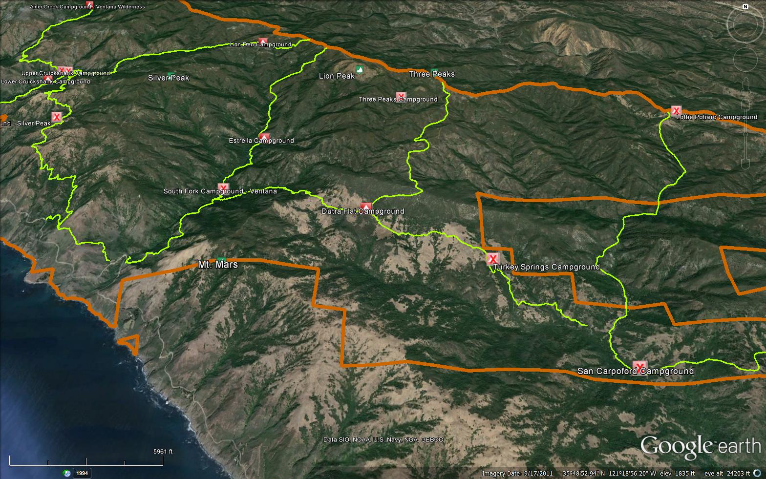
The Spruce Creek Trail is a scenic 5.07 mile trail in the Silver Peak Wilderness in Monterey County . The trail connects the Salmon Creek Trail (6E11) to the Dutra Trail (6E09) and the Lottie Potrero Trail (7E01). Please let us know if you have explored this trail recently.


 Spruce Creek Trail Survey - 05-18-2018 - by tepuerling
| Link: | Spruce Creek Trail |
| Date: | 05-18-2018 |
| Surveyor Name: | tepuerling |
| Trail description: | Walked through a lot of harmless spider webs. If you're looking for the Dutra Flats campground, traveling East, it's in the second open area - don't stop at the first clearing, keep going along the path. |
| Mode of transport: | Hike |
| Trail condition: | Good shape and easy to follow |
Spruce Creek Trail Survey - 12-30-2017 - by Steve Cypher| Link: | Spruce Creek Trail |
| Date: | 12-30-2017 |
| Surveyor Name: | Steve Cypher |
| Trail description: | VWA volunteers cut some big logs and made a safe path across the big slide next to Spruce Creek. Still one log in the middle to step over and a couple to duck under a little higher up the trail. This may look completely different after winter rains. |
| Mode of transport: | Hike |
| Trail condition: | Needs some work |
| Condition details: | Big slide cleared for now |
| Images: | |
Spruce Creek Trail Survey - 12-02-2017 - by Steve Cypher| Link: | Spruce Creek Trail |
| Date: | 12-02-2017 |
| Surveyor Name: | Steve Cypher |
| Trail description: | Spruce Creek Trail has been getting regular use and now has well-tromped paths through the meadows and around the blow-downs in the woods. There is some work being done to make getting past the landslide and 3 giant logs about a mile up from Salmon Creek safer. The moist ground makes footing safer crossing the slide right now. |
| Mode of transport: | Hike |
| Trail condition: | Needs some work |
| Condition details: | Meadows are trampled, trail is easier to follow. |
Spruce Creek Trail Survey - 04-22-2017 - by Steve Cypher| Link: | Spruce Creek Trail |
| Date: | 04-22-2017 |
| Surveyor Name: | Steve Cypher |
| Trail description: |
I hiked the Spruce Creek Trail east from Dutra Flat Camp to Baldwin Ranch Rd. on a perfect sunny afternoon. There is zero chance I would have been able to stay on the trail if not for a map printed from bigsurtrailmap.net. I’d have lost the trail in the meadows and not followed the sharp left before Turkey Sprs. But if you know where the trail is supposed to be, you can find it. In response to Robert Gunn’s report of 4/16/17, the left option at the cairn west out of Dutra Flat Camp is the Murry Mine Track, which is the easiest route to Dutra Flat from Ragged Point Inn. I recently cleared this trail myself (you’re welcome) to allow packed horses to deliver dinner to a volunteer trail crew at Dutra Flat in March. Murry Mine Track connects to County Line Road at the top of the ridge and was the road to the Murry mercury mine near Dutra Creek in the mid 20th century. The Murry Mine Track and the Dutra Use Trail, the most direct trails from Ragged Point to Dutra Flat, can be seen at bigsurtrailmap.net – select “Big Sur Trailmap†vice “Trail Conditionsâ€. Murry Mine Track from Ragged Point to Dutra Flat is ~ 6 miles of wide, scenic, easy trail, and Dutra Use Trail is narrow and steep, but only about 5 miles Ragged Point to Dutra Flat. |
| Mode of transport: | Hike |
| Trail condition: | Hard to follow |
| Condition details: | Faint in meadows, narrow through woods. |
| Images: | Spruce Creek Trail through meadow east of Dutra Flat. |
Spruce Creek Trail Survey - 04-16-2017 - by Robert Gunn| Link: | Spruce Creek Trail |
| Date: | 04-16-2017 |
| Surveyor Name: | Robert Gunn |
| Trail description: | Two teenagers and mom and dad enjoyed spring break by backpacking the Silver Peak Wilderness. Unaware of the Highway 1 closure 100 yards north of the Ragged Point Inn until we had already traveled from our home in Sacramento to San Luis Obispo county, we hoped that Cal Trans would let us walk up the last four miles from the road closure to Salmon Creek trailhead. A very friendly Cal Trans worker however turned us away, but was kind enough to share that people were hiking around the closure via Baldwin Ranch Road, which starts a few hundred feet south the Ragged Point Inn. The receptionist at the Inn was nice enough to give us permission to park our car in the Inn lot, and we hiked Baldwin Ranch Road east about 6 miles to where it meets the east end of Spruce Creek trail. Baldwin Ranch road by the way is a very steep at times fire trail that our 4-wheel drive would have been incapable of negotiating, and is blocked by a locked gate where it meets Highway 1. Other than the steep grades it is a scenic hike with lots of wild flowers and ocean views. The actual junction with Spruce Creek trail is virtually impossible to spot, save for a weathered sign post facing west-bound travelers on Baldwin Ranch Road. It starts in a meadow with 2' tall grass and basically no track until the trail enters the forest. From that point on it is fairly easy to follow in daylight all the way to Dutra Camp, though nighttime hiking would be more difficult. From Dutra Camp traveling west, there is Y intersection about 1/4 mile from Dutra Camp that is not signed. The path going left at the Y is slightly more traveled, has had some professional-looking trail clearing performed on it through a grove of manzanita in the the first 1/4 mile or so, and had a rock cairn indicating the left trail at the Y, so we took it. It was raining and misty and it took us an hour and a half or so to realize it was some other trail and wasn't going to take us to Salmon Creek. We hit the Y after a lunch at Dutra Camp, and eventually turned back and camped at Dutra Camp. The next morning we took the right arm of the Y after moving the rock cairn over to that arm, and this time were rewarded by crossing Dutra Creek near its headwaters as is shown on the Trails Illustrated map, and not on a much lower section of Dutra Creek where the left at the Y takes you (and that requires removing boots to ford). Looking at the map my best guess is that the left Y eventually ends up at Mount Mars, as we had followed it the day before to about 2100' elevation up onto a south-climbing ridge. It is not a trail in the sense of Spruce Creek or Salmon Creek trails, but rather a series of former logging(?) or ranching(?) roads utilized now with some pink ribbons to create a trail. Anyone following Spruce Creek trail from the west heading east would not have any problem with this Y intersection, and would know which arm to take on the way back, but this was our first time in the S.P. wilderness and entering as we did from Baldwin Ranch Road we missed the opportunity to figure it out the easy way! Once into the Spruce Creek watershed the traveling was excellent with a surprisingly small number of trees down considering the winter rains, until we hit a major slide about a half mile from the Salmon Creek trail junction. It has 3 or 4 large fir tree blocking the hill, with approximately 100' of trail lost in the rock slide (photos attached). In drier weather it would be easier to scramble across it than in the rain that we had that day. There is a lot of loose rock, and the slide is steep enough in sections that the footing is questionable. Once across it the rest of the trail was clear down to the junction. There is a fair amount of poison oak on sections of this trail. I brought hand pruners along and cleared out sections where the poison oak couldn't be gotten by without brushing into it, as my wife and daughter both have strong reactions to the oil. A few sections were so heavy and open grassland was nearby that it was easier to leave the trail and then rejoin it 20 or 30 yards later. The hike out on Highway 1 to Ragged Point Inn was beautiful. Don't be deterred if you're thinking of visiting this wilderness by the highway closure! Hopefully we'll be fortunate enough to get to take another backpack through Silver Peaks soon. Happy hiking! |
| Mode of transport: | Hike |
| Trail condition: | Needs some work |
| Condition details: | Major slide near the Salmon Creek trail/Spruce Creek trail junction |
| Images: | |
 Survey / Report Form - Please click this box to open the form.