 Use Marker Groups
 Wolf 2002
Piru 2003
Day 2006
Zaca 2007
Gap 2008
La Brea 2009

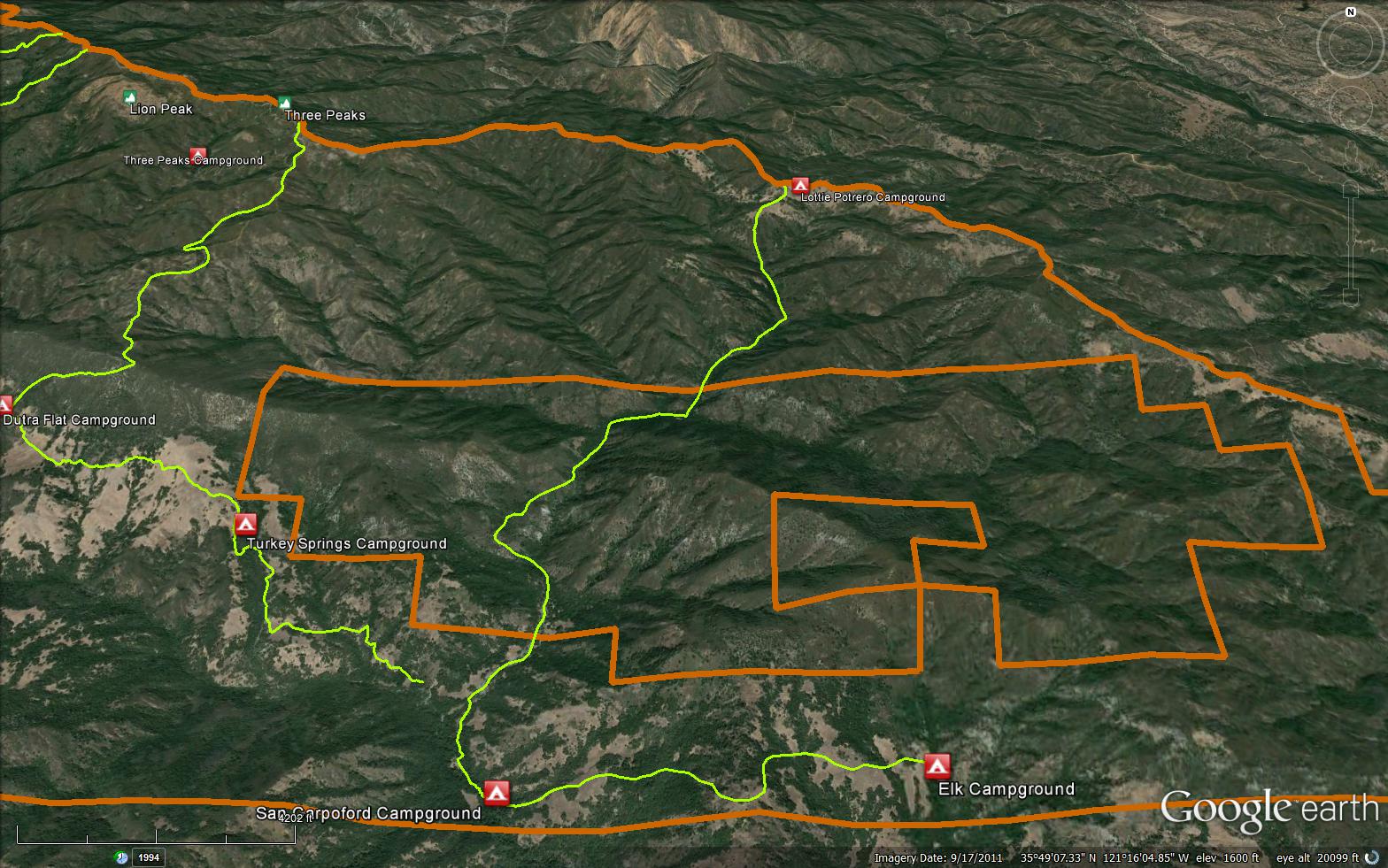
The Lottie Potrero Trail is a senic 5.96 mile trail in the Silver Peak Wilderness in Monterey County County. Please let us know if you have explored this trail recently.


 Lottie Potrero Trail Survey - 01-06-2024 - by Steve Cypher
| Link: | Lottie Potrero Trail |
| Date: | 01-06-2024 |
| Surveyor Name: | Steve Cypher |
| Trail description: | There's been a little traffic and clearing on this trail lately. It's easier to follow than 4 years ago, but still a difficult brushy trail. Some crawling was required. I never felt lost but rate it hard to follow. Worth noting is the road walk back to the 3 Peaks area is challenging with lots of tough climbs. |
| Mode of transport: | Hike |
| Trail condition: | Hard to follow |
| Condition details: | Very brushy faint trail. |
Lottie Potrero Trail Survey - 02-16-2020 - by Steve Cypher| Link: | Lottie Potrero Trail |
| Date: | 02-16-2020 |
| Surveyor Name: | Steve Cypher |
| Trail description: | I returned to Lottie Potrero Trail with some other guys who helped clear and flag. The trail is rough but easy to follow from Baldwin Ranch Road to Davis Canyon. From there to Heisel Cabin and meadow it's a combination of game trails on the north slope trying to avoid poison oak. From Heisel Cabin to the South Coast Ridge Road it's a faint brushy trail requiring lots of crawling on hands and knees with poison oak in the face and trackless meadows. Most maps, including the one here, show both ends of the trail in the wrong places. Get gps data at bigsurtrailmap.net. |
| Mode of transport: | Hike |
| Trail condition: | Hard to follow |
| Condition details: | Faint, brushy, epic poison oak |
Lottie Potrero Trail Survey - 01-19-2020 - by Steve Cypher| Link: | Lottie Potrero Trail |
| Date: | 01-19-2020 |
| Surveyor Name: | Steve Cypher |
| Trail description: | I hiked up the trail towards Wagner Creek from Baldwin Ranch Rd. You go through the gate at the Buddhist monastery and take the second left heading up the mountain maybe 100 yards past the gate. There are several ranch roads going in many directions and no signs to indicate where the Lottie Potrero Trail is. I had to follow the gps track from bigsurtrailmap.net. The trail starts as an old road but gets very narrow as it traverses the mountainside above San Carpoforo Creek. I worked most of the day clearing this section of the trail and then camped at a large flat spot near the trail in Davis Canyon. Lots of water in creeks. In the morning I explored up the trail but lost it soon after it turned up the drainage towards the South Coast Ridge Road. The trail is now easy to hike all the way to Davis Canyon and I'm hoping clear the rest soon. There is lots of poison oak on this trail. The old maps are very inaccurate near Baldwin Ranch and Lottie Potrero Camp. Get gps data from bigsurtrailmap.net if you want to explore this. |
| Mode of transport: | Hike |
| Trail condition: | Hard to follow |
| Condition details: | Rough old trail hardly used |
| Images: | Narrow trail above Davis Canyon Looking down San Carpoforo Creek from trail |
Lottie Potrero Trail Survey - 07-07-2019 - by Steve Cypher| Link: | Lottie Potrero Trail |
| Date: | 07-07-2019 |
| Surveyor Name: | Steve Cypher |
| Trail description: | I hiked the lower part of this trail from Baldwin Ranch Rd to Elk Camp. There is a small sign next to the road indicating a trail leading towards San Carpoforo Creek. There was evidence of regular motor vehicle use on the trail although it is within Silver Peak Wilderness. The vehicle use makes the trail easy to follow and not too brushy across the creek twice to a wide flat spot where people have camped. Past that the trail is more difficult to discern. There's a nice fire ring on the gravel bar next to the creek that may be what's left of San Carpoforo Camp. Further downstream is a well-used ATV path up the opposite bank where the trail continues. The ATVs turn off in the first big meadow and you need to cross heading up hill towards the south side of Jones Mtn. If you have gpx data from Bigsurtrailmap.net you can find the faint trail when it leaves the meadows and enters the woods. The final meadow is below a big cone-shaped rock. Beyond on the mountain side is a rock formation that looks like a dragon above the drainage where Elk Camp is. The camp is on the east side of this meadow and you can see the picnic table as you approach. Water at the camp was good. This hike is slow but short and the scenery is great. |
| Mode of transport: | Hike |
| Trail condition: | Hard to follow |
| Condition details: | From Baldwin Ranch Rd to Elk Camp |
| Images: | Possibly San Carpoforo Camp Elk Camp Dutra Creek drainage from trail to Elk Camp |
Lottie Potrero Trail Survey - 04-20-2019 - by Steve Cypher| Link: | Lottie Potrero Trail |
| Date: | 04-20-2019 |
| Surveyor Name: | Steve Cypher |
| Trail description: | Just so you know. This trail is pretty much abandoned. People don't hike it. I explored the upper part of this trail. There is no hint of a trail leaving the South Coast Ridge Road. Using the gps file from bigsurtrailmap.net, I followed my phone down a steep meadow and found two rock cairns, then a faint ancient tread and some faded remains of flagging tape headed into the woods. Lottie Potrero Spring on the gps file was a muddy seep, although most water sources are flowing nicely now. There is private property at the bottom of the trail. There was a bypass around at one time. I'd love to explore the whole trail someday. But it will take plenty of time and willingness to search for artifacts of a historical trail while pushing through poison oak and other heavy brush. I encountered two backpackers while driving back on the South Coast Ridge Road. They were headed to the Lottie Potrero Trail as part of a 3-day loop itinerary. They were unfamiliar with the area so I did my best to talk them out of it. |
| Mode of transport: | Hike |
| Trail condition: | Non existent |
| Condition details: | Unused Trail |
 Survey / Report Form - Please click this box to open the form.