 Use Marker Groups
 Wolf 2002
Piru 2003
Day 2006
Zaca 2007
Gap 2008
La Brea 2009

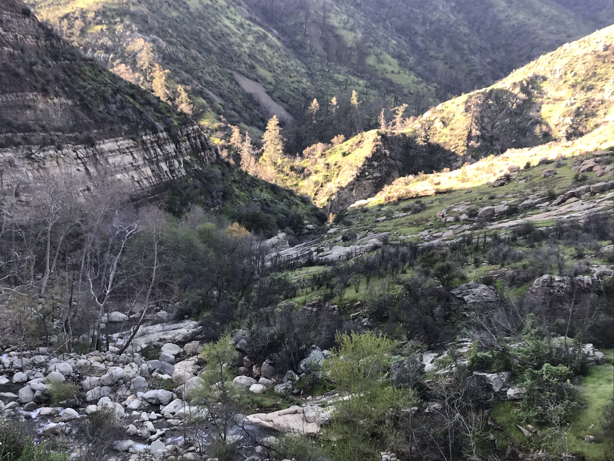
A beautiful trail in the Sespe Wilderness that connects the Santa Paula Canyon Trail (21W11) and the Red Reef Trail (21W08). At Cross Camp are several large waterfalls and deep pools that provide excellent swimming spots in the bottom of the narrows.


.png)


 Last Chance Trail Survey - 12-30-2025 - by Holden A. Branch
| Link: | Last Chance Trail |
| Date: | 12-30-2025 |
| Surveyor Name: | Holden A. Branch |
| Trail description: | Once over the river, it's quite easy to get follow the trail at least to Jackson Hole. would definitely recommend a GPS app with maps so you can see where the trail is, especially when getting down to the Hole. or get poison oak. what do I care |
| Mode of transport: | Hike |
| Trail condition: | Needs some work |
| Condition details: | LOTS of fallen shrubs and trees and whatnot towards Jackson Hole, difficult to follow down to the Hole aswell. |
Last Chance Trail Survey - 04-19-2025 - by Laura Clay| Link: | Last Chance Trail |
| Date: | 04-19-2025 |
| Surveyor Name: | Laura Clay |
| Trail description: | Hiked in 4/19 with intent to stay at Jackson Camp. After splitting from the Santa Paula Canyon Trail, things became increasingly difficult and after crossing the water at Cross Camp, the trail wasn't terrible but there eventually became so many instances of losing the trail and bushwhacking that we gave up short of camp and hiked all the way back to the trailhead. Plenty of water in the creek right now though |
| Mode of transport: | Hike |
| Trail condition: | Needs some work |
| Condition details: | Very tough to find after Cross Camp |
Last Chance Trail Survey - 10-07-2023 - by Andy| Link: | Last Chance Trail |
| Date: | 10-07-2023 |
| Surveyor Name: | Andy |
| Trail description: | I made it to Jackson then turned around. Trail is brushed in and has some significant, dangerous washouts. Jackson Falls is dry, but creek is now running on a new path with plenty of water. Trail appears to be marked on AllTrails as part of the popular Punchbowls route, leading to interactions with some unprepared hikers. |
| Mode of transport: | Hike |
| Trail condition: | Hard to follow |
Last Chance Trail Survey - 11-20-2022 - by Adam Donald| Link: | Last Chance Trail |
| Date: | 11-20-2022 |
| Surveyor Name: | Adam Donald |
| Trail description: | Only went as far as Jackson Camp from the Santa Paula Canyon side. The trail was pretty well brushed in, and had lots of fallen dead or burned trees that the wind had uprooted and blown across the trail. We moved some, but would have needed a saw for several others. The trail looked equally brushy continuing north, so we camped at Jackson and turned around the next day. Other than finding start of the switchbacks above the swimming holes, it was easy enough to follow but wear long sleeves and pants. Easy access to water at Cross and Jackson camps. |
| Mode of transport: | Hike |
| Trail condition: | Needs some work |
| Condition details: | Wear long sleeves/pants |
Last Chance Trail Survey - 03-30-2022 - by Menso de Jong| Link: | Last Chance Trail |
| Date: | 03-30-2022 |
| Surveyor Name: | Menso de Jong |
| Trail description: | I ran from SPC to Jackson Hole Camp and back. Without GPS, I would not have found the crossing to start up the switchbacks from Cross Camp as the mainly trafficked trail continues up the canyon to the swimming holes and the junction is unmarked. Once I crossed the creek and found it, it was easy enough to follow to Jackson Hole Camp, but quite brushy, with several sections of "breast stroking" through brush fully encroaching upon the trail. There is plenty of water in the creek after the ~2"of rain several days ago, and the wildflowers are blooming around every corner. |
| Mode of transport: | Hike |
| Trail condition: | Needs some work |
Last Chance Trail Survey - 05-27-2021 - by Josie| Link: | Last Chance Trail |
| Date: | 05-27-2021 |
| Surveyor Name: | Josie |
| Trail description: | From Cross to Jackson Camp, trail is in good shape and easy to follow, if a little brushy in places. From Jackson Camp to Jackson Hole is so-so but doable, keep your eyes up. We couldn't figure it out once we got a little past Jackson Hole -- there were a few cairns in the creek, but it wasn't clear to us where you should pop back out to head uphill for Last Chance. Someone who knows the old route might be able to pick their way through. Gorgeous up there, even if we couldn't get as far as we had hoped. |
| Mode of transport: | Hike |
| Trail condition: | Hard to follow |
| Images: | A cairn marks the way to Jackson Hole. Early morning on the way to Jackson Camp. |
Last Chance Trail Survey - 11-21-2020 - by Antonio Calderon| Link: | Last Chance Trail |
| Date: | 11-21-2020 |
| Surveyor Name: | Antonio Calderon |
| Trail description: | Trail is in great condition from trailhead to cross camp. Brand new trail signs guide you through out this stretch. The creek was flowing all through this section. From cross camp to to Jackson camp the trail is getting overgrown again and ticks were out and about. Had to stop several times to brush off ticks. From Jackson falls to last Chance camp the trail is sporadic becoming apparent in some places and others not so much. |
| Mode of transport: | Hike |
| Trail condition: | Needs some work |
| Images: | |
Last Chance Trail Survey - 11-23-2019 - by Christopher P. Lord| Link: | Last Chance Trail |
| Date: | 11-23-2019 |
| Surveyor Name: | Christopher P. Lord |
| Trail description: | Dropped onto the Last Chance Trail From TopaTopa Bluff on Saturday 11/23/19. For a trail that gets little to no maintenance surprisingly the first 1 to 1.5 miles was fairly easy to follow. Yeah the brush gets thick in spots, but could be much worse. That being said the trail then becomes very overgrown the last 1 to 1.5 miles into TopaTopa Lodge Camp. Speaking of TopaTopa Lodge can we get that added to the HLP site? Camp coordinates  N34° 30' 01.4" W119° 04' 53.9" . The Camp is in fine shape and ready for visitors. See attached photos. Water was available to filter in both tributaries before the Lodge and the best water was found in the Connector 1/4 mile North of the Lodge. Exited the Connector 21W20 back up and onto Red Reef to Summit Hines and Cream Puff. If nothing you just read makes sense it is because this site and most currents maps have the Last Chance trail marked incorrectly. The historic trail did not connect with Red Reef between Hines and Cream Puff (No Name) but rather much closer to the Red Reef near the Northern terminus of TopaTopa bluff. More details at the link below. |
| Mode of transport: | Hike |
| Trail condition: | Hard to follow |
| Images: | TopaTopa Lodge Camp Topa Topa Lodge Camp View Toward Hines Peak 1969 map showing the original Last Chance Trail |
Last Chance Trail Survey - 03-24-2019 - by Christopher P. Lord| Link: | Last Chance Trail |
| Date: | 03-24-2019 |
| Surveyor Name: | Christopher P. Lord |
| Trail description: | From the junction with the old east fork trail to Jackson Hole Camp with a little diligence is fairly easy to follow. From the Camp up to the Falls it becomes more difficult. Beyond Jackson Hole to Last chance Camp is apparent in places and completely non existent in others. Which should come as no surprise since the trail has been abandoned for decades. The higher ridge region before Last chance Camp miraculously does still have a nice cut through the head high brush. Should you attempt a visit know the old trail route before heading in and pick the path of least resistance as you go. The beauty of the Santa Paula Canyon is hard to beat as far as Los Padres standards are concerned. Water is reliable in the Main fork of Santa Paula and all it's tributaries as of this writing. Trail marker sign on the ridge before last chance is missing only the post remains.(N34.48021° W119.05197°) Should you like further details you can visit the link below. |
| Mode of transport: | Hike |
| Trail condition: | Hard to follow |
| Images: | Lower Falls and start of the Last Chance Trail Seasonal waterfall Trail sign on the ridge south of Last Chance Camp (N34.48021° W119.05197°) Hines and No name Peak from 21W09 |
Last Chance Trail Survey - 12-09-2018 - by Reece M| Link: | Last Chance Trail |
| Date: | 12-09-2018 |
| Surveyor Name: | Reece M |
| Trail description: | Alright so this was my 2nd attemot at they Last chance trail & today i was met with with much more success. Idk if it was the recent rains that we had or if someone came through & did some serious work but the trail was 10x easier to follow. I Left the TA trail head at 8:30 & made it to Jackson falls by 11:17. The falls were flowing nicely & it was awesome to see for the first time. I missed Jackson home camp due to it being marked incorrectly on the map on this website. I was looking above the fall turns out the camp is below. After the falls the trail disappears & the sides of the canyon are completely washed out. Your left to rock hopping until you reach a fork in the canyon & the switchbacks pick up again. I made it about half way up the first ridge & the views were amazing I could see all the way to the ocean. It was about 12:30 at this time so I figured I’d better eat lunch & turn around if I wanted to be out before dark. Jackson Falls was a success, Last chance camp eluded me once again. I will be coming back to finish this hike but I will either leave at 6 am or bring a tent lol. Awesome trial, I highly recommend this hike! It was great to see so many familiar places from new vantage points |
| Mode of transport: | Hike |
| Trail condition: | Needs some work |
| Condition details: | Beautiful rugged country |
| Images: | |
Last Chance Trail Survey - 11-09-2018 - by Reece M| Link: | Last Chance Trail |
| Date: | 11-09-2018 |
| Surveyor Name: | Reece M |
| Trail description: | Set out from Thomas Aquinas yesterday hoping to make it to Last Chance camp. I had never been past the 3rd punch bowl previous to this. After doing extensive google earth research i felt fairly confident I’d be able to find the old trail. I crossed the creek at cross camp & started trekking up the hill until I managed to find sections of the trail. Good route finding skills & a tenacious attitude will help big time. Your on an overgrown trail about 50% of the time the other half your headed in what seems to be the direction of said trail. Bushwhacking prevails here.I made it to a nice section above the canyon with views of big cone, the 3rd punch bowl & buck falls. I believe I could see the beginning of Jackson falls as well. Unfortunately my dog started over heating so I had to turn around. I will definitely becoming back with out the dog soon to finish this route. He’s a good companion but he’s only about 40lbs & all black so he gets hot fast. Beautiful rugged country. I recommend coming with someone who’s been here before to increase your odds of finding the trail. It switches back n forth across the ridge quite a bit |
| Mode of transport: | Hike |
| Trail condition: | Hard to follow |
| Condition details: | Trail isn’t non existent in many places after cross camp |
Last Chance Trail Survey - 05-19-2018 - by Anon| Link: | Last Chance Trail |
| Date: | 05-19-2018 |
| Surveyor Name: | Anon |
| Trail description: | While the fire has made the area much more open and visible, the trail is nearly non-existent. Very difficult to follow it past Cross Camp, and it was impossible to find it past the first ridge (was much easier to find it pre-fire, though still difficult). Could not make it to Jackson Hole via the trail. May take the canyon route next time. |
| Mode of transport: | Hike |
| Trail condition: | Non existent |
Last Chance Trail Survey - 05-10-2018 - by Anonymous Surveyor| Link: | Last Chance Trail |
| Date: | 05-10-2018 |
| Surveyor Name: | Anonymous Surveyor |
| Trail description: | I followed the East Fork Trail from Thomas Aquinas College. I managed to find the beginning of the Last Chance Trail from Big Cone Campground when leaving the river. Portions of the trail above the punch bowl are covered the downed trees and the slope has given away in spots where reinforcements where previously made. Getting to Cross Camp was fairly obvious, However, there were no trail markings or signage at cross camp to give direction of travel. I searched all around the canyon around Cross Camp and was unable to locate the continuation of Last Chance Trail. After returning home and downloading GPS data, I discovered that I was actually in the area of the previous trail when heading north from Cross Camp which confirmed that the trail is no longer visible in the New Growth following the Thomas Fire and soil run off from previous rains. The trail is in beautiful country and I hope it receives desperate attention in the future for continued use. |
| Mode of transport: | Hike |
| Trail condition: | Non existent |
| Condition details: | Trail is overgrown and asbent past cross camp |
| Images: | |
Last Chance Trail Survey - 01-18-2016 - by JO| Link: | Last Chance Trail |
| Date: | 01-18-2016 |
| Surveyor Name: | JO |
| Trail description: | The last chance to travel the Last Chance Trail above Jackson Camp, may have passed.  Above the turn off to Jackson camp, a kind, benevolent hiker has left 2 ropes at the big trail slide that occurred in the 2005 flood, to aid hikers in getting up and out of the rock faced drainage where it appears the trail ends.  There is the section (maybe .5 mile) between Jackson Hole and the ridge where the trail leaves the creek where no trail seems to exist, where rock hopping and bushwhacking prevail. Once you get on the ridge the trail improves a bit.  Be on the lookout for a car sized boulder with a cairn looking pile of rocks on the top. Don’t head for this, you need to be above this. We lost the trail in this spot and ended up on the side of a steep, loose, and dangerous scree slope. There is a trail, but it’s not obvious. At a certain point the trail crosses a wide brush-less open area with a sign post without the sign. Is there somebody out there that knows what destinations with mileages were on that sign? After this area the trail gets worse. We managed to arrive at Last Chance camp at 2:30 PM having left the car at 5:30 AM. We wanted to reconnoiter the trail to Topa Topa that a woman professor at Aquina's college established or even the old route to the Red Reef trail that meets it near Hines peak, but visibility was about 25 yards. Lost the trail more times on the return than on the ascent. If you’ve been to LCC before, you might be able to find it again. If you’ve never been there, but are an above average map reader you might have a 50-50 chance. |
| Mode of transport: | Hike |
| Trail condition: | Hard to follow |
| Condition details: | Started at T Aquinas College on hwy 150. Turned around at Last Chance Camp. Couldn't see to navigate to Red Reef Trail. |
| Images: | first rope 2nd rope car sized boulder to stay above cliff looking into SP creek from Last Chance ridge trail signpost without the sign |
Last Chance Trail Survey - 10-12-2015 - by Jeremy Scarlett| Link: | Last Chance Trail |
| Date: | 10-12-2015 |
| Surveyor Name: | Jeremy Scarlett |
| Trail description: | Trail is little difficult to find out of Cross Camp but once on it, there is pink tape markers and then mostly small cairns to make the way. There was a tin box with notes in in, looks like no one had been by since August 2015. We only went up about a mile past Cross Camp, didn't make it to Jackson Hole. Trail was a little brushy in spots, recommend long pants and sleeves. |
| Mode of transport: | Hike |
| Trail condition: | Needs some work |
Last Chance Trail Survey - 12-30-2014 - by Chad Larrieu| Link: | Last Chance Trail |
| Date: | 12-30-2014 |
| Surveyor Name: | Chad Larrieu |
| Trail description: | Just spent four days, three nights camping at Jackson Hole, with two full days to explore the route North. We marked trails with pink flagging tape. I have been in the area before and never made it far beyond Jackson Hole Camp. Water flows there periodically, so the campsite was nice after the recent rains. There are foxes and rintailed cats in the area, so we hung our food. The trail is pretty rough beyond Jackson Hole.We were able to make it to a large rockslide/boulder field with a lone signpost (minus the sign), about 1.5 miles from the campsite. From there, we lost the trail. |
| Mode of transport: | Hike |
| Trail condition: | Hard to follow |
| Condition details: | Discernible trail from Cross Camp to Jackson Hole, impassible beyond 1.5 mi after Jackson Hole |
Last Chance Trail Survey - 03-22-2014 - by Bela B.| Link: | Last Chance Trail |
| Date: | 03-22-2014 |
| Surveyor Name: | Bela B. |
| Trail description: | We hiked up to Jackson Hole Campground. That part of the trail is in good condition. After the campground, the trail pretty much disappears. We didn't have much time to look for it, so maybe it gets better again after crossing the creek, but if you plan to continue up the trail be prepared for bad trail conditions. |
| Mode of transport: | Hike |
| People Seen: | 1 |
 Survey / Report Form - Please click this box to open the form.