 Use Marker Groups
 Wolf 2002
Piru 2003
Day 2006
Zaca 2007
Gap 2008
La Brea 2009

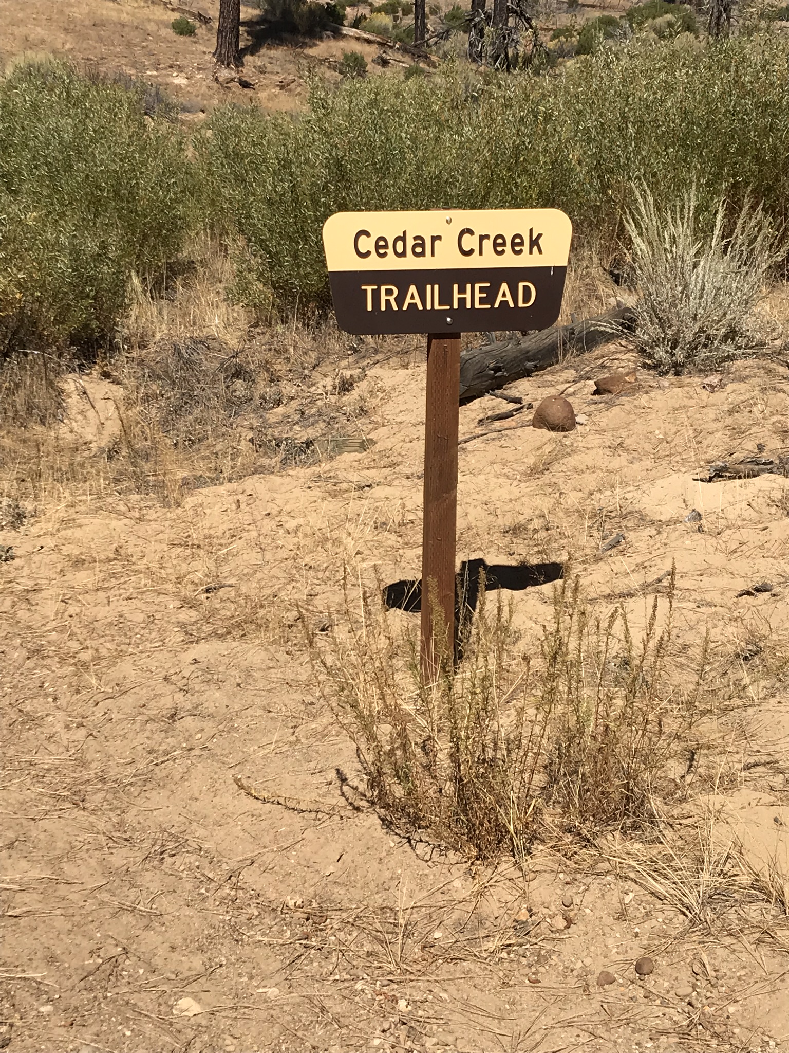
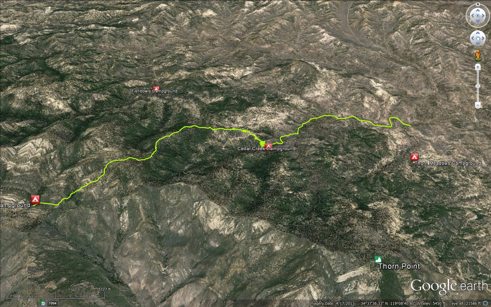
A beautiful trail located in the Sespe Wilderness, the trailhead is located on Thorn Medow Road (7N03B) a short side road off Mutah OHV Road (7N03.2). The Cedar Creek Trail connects Thorn Medow Road (7N03B) and the GeneMarshall-Piedra Blanca Trail (22W03). This trail has numerous stands of Incense Cedar trees along the upper portion. Numerous large Sugar Pine and Jeffery Pines also grow along the canyon, especially at Cedar Creek Trail Camp. The Cedar Creek Trail 21W10 climbs the canyon before descending to Fishbowls Camp at the north fork of Piru Creek, the trail then completes at Pine Mountain Lodge Camp.


 Cedar Creek Trail Survey - 05-10-2026 - by Anonymous Surveyor
| Link: | Cedar Creek Trail |
| Date: | 05-10-2026 |
| Surveyor Name: | Anonymous Surveyor |
| Trail description: | A few new down trees since 2024 but can walk over them. Bear tracks. Switchbacks weren’t too brushy. |
| Mode of transport: | Hike |
| Trail condition: | Good shape and easy to follow |
Cedar Creek Trail Survey - 02-04-2026 - by Diane Soini| Link: | Cedar Creek Trail |
| Date: | 02-04-2026 |
| Surveyor Name: | Diane Soini |
| Trail description: | The trail was hard to find at the beginning. The trail sign at the bottom is fallen over and there is no visible tread for quite some distance. There are many wild roses to walk through. After a while the trail is easy enough to follow and in good condition all the way to Cedar Creek Camp. The climb up to the top is all good trail. From the top the trail is a little hard to follow, especially in the dark, down to Pine Mountain Lodge. |
| Mode of transport: | Hike |
| Trail condition: | Needs some work |
| Condition details: | The beginning of the trail is hard to find, many wild roses |
Cedar Creek Trail Survey - 12-26-2023 - by Anonymous | Link: | Cedar Creek Trail |
| Date: | 12-26-2023 |
| Surveyor Name: | Anonymous |
| Trail description: | Water was abundant. Other than the 1.5miles to the peak and down, we didn't walk more than a quarter mile without having direct access to water. The trail was easy to follow. Tons of signs of bear, but we didn't see any. A gorgeous trail. The creek followed almost the entire way. Some of the trail is loose sand, so be ready for a bit of a calve workout. |
| Mode of transport: | Array |
| Trail condition: | Good shape and easy to follow |
Cedar Creek Trail Survey - 05-20-2022 - by Anonymous Surveyor| Link: | Cedar Creek Trail |
| Date: | 05-20-2022 |
| Surveyor Name: | Anonymous Surveyor |
| Trail description: | A couple of switchback sections cutting across steep-sided hills are almost impassable and dangerous with sliding dirt/scree. Go back and find alternate spur trail for safety, until the trail is worked on. |
| Mode of transport: | Hike |
| Trail condition: | Needs some work |
| Condition details: | Upper part from Cedar Creek Camp to Fishbowls Trail junction |
Cedar Creek Trail Survey - 05-06-2022 - by Los Padres Forest Association| Link: | Cedar Creek Trail |
| Date: | 05-06-2022 |
| Surveyor Name: | Los Padres Forest Association |
| Trail description: | A group of MPRD volunteers spent the day logging out 8 downed trees from across the lower part of the Cedar Creek Trail. More work is needed but this will certainly help! Thanks volunteers..... |
| Mode of transport: | Array |
| Trail condition: | Needs some work |
| Images: | |
Cedar Creek Trail Survey - 05-07-2022 - by Tom Fritz| Link: | Cedar Creek Trail |
| Date: | 05-07-2022 |
| Surveyor Name: | Tom Fritz |
| Trail description: | I hiked this as a portion of a larger trip, entering rom Pine Mountain Lodge to Fishbowls, and exited at the "new" trailhead off Grade Valley Rd. As usual, beautiful views abound. The trail was clear of blowdowns that caused great effort. No real choke-points brush-wise. The Piru is flowing quite well at Fishbowls, and is flowing constantly until you reach the cable. Stepped across each crossing; never got a foot wet. After the cable, it flows on the surface, then disappears. The Fishbowl in camp itself is still about 4'- 5' deep. There hasn't been enough flow in the past couple years to get it good and deep. Observation: the forest surrounding Fishbowls camp is stressing. Trees are sick/dying/falling. More trees have fallen in camp. I've noticed this is happening more frequently within the past several years; comparing it with how it used to look in the mid 70s when I first started coming here. |
| Mode of transport: | Hike |
| Trail condition: | Good shape and easy to follow |
| Images: | Fishbowl, May 3 2022 Piru creek flow, about 2 miles upstream from "new" trailhead. |
Cedar Creek Trail Survey - 05-01-2022 - by The Lost Padre| Link: | Cedar Creek Trail |
| Date: | 05-01-2022 |
| Surveyor Name: | The Lost Padre |
| Trail description: | Some large trees are down between the trailhead & Cedar creek camp. Several dead oaks that were in the trail above camp have been cleared. Tread needs work in a few spots around & above switchbacks on the way to Pine Mtn lodge/Fishbowls Junction |
| Mode of transport: | Hike |
| Trail condition: | Needs some work |
| Condition details: | Always a great view! |
Cedar Creek Trail Survey - 03-30-2022 - by Tim| Link: | Cedar Creek Trail |
| Date: | 03-30-2022 |
| Surveyor Name: | Tim |
| Trail description: | Hiked entire length from Pine Mountain Lodge to Thorn Meadows. There were 4 inches of snow on the ground from a storm the night before, so the beginning section from Pine Mountain was difficult to follow due to either being covered with snow or having turned into a small creek. Once we were below the snow line, the trail was easy to follow, except for a section where there was evidence of work from a previous fire. It looked like a false trail veered off to the side and back, but that might have been from the fire fighters; the proper trail continued along the ridge. Otherwise, no issues and the trail was great. |
| Mode of transport: | Hike |
| Trail condition: | Good shape and easy to follow |
Cedar Creek Trail Survey - 11-04-2021 - by Los Padres Forest Association| Link: | Cedar Creek Trail |
| Date: | 11-04-2021 |
| Surveyor Name: | Los Padres Forest Association |
| Trail description: | LPFA Trail Survey Cedar Creek is in good shape, no issues to report other than some moto damage and the occasional downed tree. Some of the upper tread could be redone but it's in fine shape by LP backocuntry standards. Enjoy..... |
| Mode of transport: | Array |
| Trail condition: | Good shape and easy to follow |
Cedar Creek Trail Survey - 06-19-2020 - by David Leoncavallo| Link: | Cedar Creek Trail |
| Date: | 06-19-2020 |
| Surveyor Name: | David Leoncavallo |
| Trail description: | We did the Cedar Creek-Fishbowls look clockwise. Easy to follow trail, plenty of water along the way. Beautiful hike. Moderate. |
| Mode of transport: | Hike |
| Trail condition: | Good shape and easy to follow |
| Images: | |
Cedar Creek Trail Survey - 06-06-2020 - by Antonio Calderon| Link: | Cedar Creek Trail |
| Date: | 06-06-2020 |
| Surveyor Name: | Antonio Calderon |
| Trail description: | From fishbowl junction to trailhead trail is in good shape . Great views descending.  A bit brushy at creek crossings but nothing major. Good  water flow. Beautiful trail. |
| Mode of transport: | Hike |
| Trail condition: | Good shape and easy to follow |
| Images: | |
Cedar Creek Trail Survey - 05-25-2020 - by Anonymous Surveyor| Link: | Cedar Creek Trail |
| Date: | 05-25-2020 |
| Surveyor Name: | Anonymous Surveyor |
| Trail description: | cedar creek trailhead to camp is in good shape. All creek crossings are small. Trail is a little brushy with a few downed trees near the camp area. From camp to pine mtn. lodge junction trail is very narrow. There are no wash out sections. |
| Mode of transport: | Hike |
| Trail condition: | Good shape and easy to follow |
Cedar Creek Trail Survey - 10-19-2019 - by Everett Amburn| Link: | Cedar Creek Trail |
| Date: | 10-19-2019 |
| Surveyor Name: | Everett Amburn |
| Trail description: | Hiked fishbowl trail to PML back through cedar creek to the fishbowl TH. There are a few blow downs in the way but easily passed. The trail is easily followed and in good condition. |
| Mode of transport: | Hike |
| Trail condition: | Needs some work |
Cedar Creek Trail Survey - 07-05-2019 - by Christopher P. Lord| Link: | Cedar Creek Trail |
| Date: | 07-05-2019 |
| Surveyor Name: | Christopher P. Lord |
| Trail description: | I connected with Cedar Creek Trail (21W10) approximately 1.3 miles Northeast of Pine Mountain Lodge as I made my descent from Cedar Peak. Trail is in fine shape and mostly really easy to follow besides a few places where erosion and or possibly the old Pine Fire hand line cuts might be causing some cutting of the trail. I counted 8 downed trees from my entry point until reaching Cedar Creek Trailhead. Lower portion of the trail within the first mile coming up from Grade Valley has been deeply rutted from heavy winter rains. Water is flowing in Cedar Creek, just before exiting I was greeted by the resident cows. More details below |
| Mode of transport: | Hike |
| Trail condition: | Needs some work |
| Condition details: | Sunny skies with temps in the 80's |
| Images: | Rutted sections |
Cedar Creek Trail Survey - 06-27-2019 - by The Lost Padre| Link: | Cedar Creek Trail |
| Date: | 06-27-2019 |
| Surveyor Name: | The Lost Padre |
| Trail description: | In need of some tread work on the north east facing ridge above the camp.There's a large tree across the trail up there as well with a use trail around it that'll cause some erosion problems |
| Mode of transport: | Hike |
| Trail condition: | Needs some work |
| Images: | |
Cedar Creek Trail Survey - 05-10-2019 - by Diane Soini| Link: | Cedar Creek Trail |
| Date: | 05-10-2019 |
| Surveyor Name: | Diane Soini |
| Trail description: | I hiked this trail from Pine Mountain Lodge to the trailhead near the Piru River. The trail was in excellent condition. I did not see a campsite at the place marked as a campsite in the topo. About 10 or a little less years ago I did this same trail and the dirt road from the trailhead to the Piru river was a mess of large blowdowns, but now the dirt road is clear of all blowdowns. Hiking down from the crest this has to be one of the most beautiful trails with the most beautiful view in the backcountry. The big trees, the oaks, the views of the Lockwood Valley. It was gorgeous. I noticed numerous small faint trails branching off that were not the trails to the Fishbowls. I was curious where they led to. |
| Mode of transport: | Hike |
| Trail condition: | Good shape and easy to follow |
Cedar Creek Trail Survey - 04-15-2019 - by Johnathan Keilman| Link: | Cedar Creek Trail |
| Date: | 04-15-2019 |
| Surveyor Name: | Johnathan Keilman |
| Trail description: | A few downed trees and the trail has been washed out from the winter storms. needs some work. |
| Mode of transport: | Hike |
| Trail condition: | Needs some work |
| Condition details: | Trail gets difficult to follow between Pine Mtn Lodge and the Cedar Creek loop |
Cedar Creek Trail Survey - 10-08-2018 - by Christopher P. Lord| Link: | Cedar Creek Trail |
| Date: | 10-08-2018 |
| Surveyor Name: | Christopher P. Lord |
| Trail description: | Trail was in excellent condition. Watch out for poison Oak when approaching Cedar Creek Camp. Water was mostly dry, however I did locate a few Very small stagnant pools near the Camp. The Piru road crossing to the Cedar Creek Trailhead was dry and easily navigable with low clearance vehicle. http://christopherplord.blogspot.com/2018/10/fishbowls-to-cedar-creek-loop.html |
| Mode of transport: | Hike |
| Trail condition: | Good shape and easy to follow |
| Images: | |
Cedar Creek Trail Survey - 05-26-2018 - by Craig R. Carey| Link: | Cedar Creek Trail |
| Date: | 05-26-2018 |
| Surveyor Name: | Craig R. Carey |
| Trail description: | As part of their final pre-summer training trip, Troop 111 Scouts (Ventura) backpacked the Cedar Creek trail from the Fishbowls junction to Thorn Meadow spur road. A few downed trees, but nothing unmanageable. Lots of creek crossings but all can be managed with dry feet. Great conditions right now. |
| Mode of transport: | Hike |
| Trail condition: | Good shape and easy to follow |
| Images: | |
Cedar Creek Trail Survey - 11-10-2016 - by Dave Burnett| Link: | Cedar Creek Trail |
| Date: | 11-10-2016 |
| Surveyor Name: | Dave Burnett |
| Trail description: | Cedar Creek Trail hike on 11/10/16 with friend, Bob. Â We started the hike at about 7:45 am with temp at 32 degrees and no wind. Â We finished at 12:30 pm with temp at 75 degrees and still no wind. Â Skies were clear all day with only minimal cloudiness. Â A very pleasant day to hike. Â Lots of evidence of brush clearance along the trail and especially on the ridge comprising the upper portion of the hike. Â Â We did not hike the entire trail, but rather had lunch and turned around about 1/4 mile beyond the junction with the Fishbowls Trail. Ascending (green track on the map included), we followed the trail. Â Descending (red track) we followed a recently cleared fire break which followed the ridge for the upper portion of the hike. Â This saved about 1.2 miles and a lot of time. (We had a minor emergency that required us to return a bit earlier than intended originally.) Â Ascending was 4.4 miles and descending was 3.2 miles. Â Â Â Â Trail was in very good shape all the way up. Â Ridge was similarly easy to follow descending, although much steeper than following the switchbacks which begin shortly past Cedar Creek Campground. Â This is a challenging hike, but very enjoyable. |
| Mode of transport: | Hike |
| Trail condition: | Good shape and easy to follow |
| Images: | Cedar Creek Trail (partial - 4.4 miles) Ascending track is green. Descending track is red. Huge fallen granary tree. Hundreds of storage holes. Hiking friend Bob shown. A distant view of Thorn Point Fire Lookout Tower. Tower is about 2 miles away, Reviewer at the high point of the hike. Thorn Point Fire Lookout Tower is far in the distance. Picture also shows an example of the fire break clearance. An unusual rock formation along the ridge descending. |
Cedar Creek Trail Survey - 03-29-2016 - by Shaddus Maximus/Los Padres Forest Association| Link: | Cedar Creek Trail |
| Date: | 03-29-2016 |
| Surveyor Name: | Shaddus Maximus/Los Padres Forest Association |
| Trail description: | One large downed tree about 3/4 of a mile east of Pine Mountain Lodge camp, and another couple of smaller downed trees east of Cedar Creek camp. None of these present much of challenge to make your way over or around. Otherwise, the trail is in excellent condition. |
| Mode of transport: | Hike |
| Trail condition: | Good shape and easy to follow |
Cedar Creek Trail Survey - 03-13-2016 - by United Trail Maintainers of California| Link: | Cedar Creek Trail |
| Date: | 03-13-2016 |
| Surveyor Name: | United Trail Maintainers of California |
| Trail description: | When the snow clears, we will bring rigging gear up and remove large down trees closer to Pine Mtn Lodge. 1 large tree and one rootball to be removed by Lancaster Outreach Center crew April 16th with UTMC. Trail due for brushing. Some light treadwork performed. |
| Mode of transport: | Stock |
| Trail condition: | Needs some work |
| Condition details: | Cleared trail of downed trees with the exception of large blockages below Pine Mtn Lodge |
Cedar Creek Trail Survey - 05-24-2014 - by Los Padres Forest Association| Link: | Cedar Creek Trail |
| Date: | 05-24-2014 |
| Surveyor Name: | Los Padres Forest Association |
| Trail description: | Information gathered by James Wapotich while on a VWR Patrol. Â You can follow James on his blog:Â http://songsofthewilderness.wordpress.com/ |
| Mode of transport: | Hike |
| Trail condition: | Needs some work |
| Condition details: | The tread is easy to follow but there are a bunch downed trees |
| Number of trees down: | 20 |
Cedar Creek Trail Survey - 03-18-2014 - by Los Padres Forest Association| Link: | Cedar Creek Trail |
| Date: | 03-18-2014 |
| Surveyor Name: | Los Padres Forest Association |
| Trail description: | The trail from Thorn Meadow to Pine Mtn Lodge is in fairly good shape. Â There are 21 downed trees but other than that the tread is easy to follow and you will not get lost. Â The sign at the Fishbowls Junction is down, that needs to be (re)installed. Â Sawyers will love this trail as there is plenty of work to be done. Â Water was along the entire stretch from the Trailhead to Cedar Creek Camp, there were patches of snow from the Fishbowls Junction up and over to Pine Mtn Lodge. Â There are a few spots above Pine Mtn Lodge where the trail is a little hard to follow, look out for cairns and flagging. |
| Mode of transport: | Hike |
| Trail condition: | Needs some work |
| Number of trees down: | 21 |
| People Seen: | 0 |
| Images: | |
 Survey / Report Form - Please click this box to open the form.