 Use Marker Groups
 Wolf 2002
Piru 2003
Day 2006
Zaca 2007
Gap 2008
La Brea 2009

The Upper Sisquoc Trail is located in the San Rafael Winderness and extends from South Fork Camp to Alamar Saddle and Manzana Schoolhouse Camp.
This trail follows back and forth across the Sisquoc River from the junction with Horse Gulch, below the Manzana School House, up to its head at Alamar Saddle on the north side of Big Pine Mountain. The Sisquoc River flows through the Sisquoc Ranch and finally joins the Cuyama River to become the Santa Maria River which empties into the Pacific Ocean southwest of Guadalupe.
About the Sisqouc River or Arroyo De Siquico
The Sisquoc River is a westward flowing river in northeastern Santa Barbara County, California. It is a tributary of the Santa Maria River, which is formed when the Sisquoc River meets the Cuyama River at the Santa Barbara County and San Luis Obispo County border just north of Garey. The river is 57.4 miles (92.4 km) long and originates on the north slopes of Big Pine Mountain, at approximately 6,320 feet (1,930 m). Big Pine Mountain is part of the San Rafael Mountains, which are part of the Transverse Ranges.
Sisquoc" is a Chumash word meaning "quail". The river is shown on an 1846 diseño of the Rancho Cuyama grant as Arroyo de Siquico.
The Sierra Madre Mountains form the watershed's boundary to the north, while the San Rafael Mountains form the southern boundary. The first half of the river, in the Los Padres National Forest, specifically the San Rafael Wilderness, travels roughly northwest. Outside of the National Forest, the river flows roughly west to its confluence with the Cuyama River, about 20 miles upstream from the Pacific Ocean. The river is completely free flowing and does not have any diversions. Its sole dam is a 3-meter dam on Horse Canyon, one of its tributaries, but it is filled with sediment and causes little restriction to the river's overall flow. It is designated as a wild and scenic river in the National Wild and Scenic Rivers System.
The watershed has a Mediterranean climate and chaparral vegetation. Annual precipitation in the watershed varies from 13 to 38 inches, 95% of which falls between November and April. This means that the river is dry part of the year, as there are no reservoirs to store water. The lack of rain also causes the vegetation to get very dry and the fire hazard can be very high during the summer.
Ecology
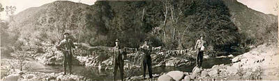
Stringer of Steelhead Trout on Upper Sisquoc River in 1916
Southern Steelhead trout (Oncorhynchus mykiss) are thought to represent about 1% of the historic population and most of the Santa Maria River run is thought to have continued up the Sisquoc River to spawn. Major dams on the Santa Ynez, Ventura, and Santa Clara Rivers prevent steelhead from accessing hundreds of miles of habitat and have drastically reduced the steelhead runs. The construction of Twitchell Dam on the Cuyama River in the late 1950s blocked at least 264 miles of stream and more than 60% of the Santa Maria River watershed and tributary habitat found upstream. This makes the Sisquoc River, which remains undammed, an important stream for surviving southern steelhead populations. Removal of dams on Sisquoc River tributaries expands the potential for restoration of steelhead. One tributary, Horse Creek (Horse Canyon), was dammed in 1968 and the 4.5 foot high, 60 foot wide dam eventually created a scour pool, increasing the drop to over 8 feet and creating an impassable barrier to spawning steelhead. The dam had completely silted in and no longer served to restrain sediment flows so was dynamited in 2006, and its sediment naturally eroded by 2011. A beaver dam created a large pool at the confluence of Horse Creek and the Sisquoc River and abundant steelhead trout were noted in a snorkel survey by fish biologist Matt Stoecker, including three fish 9 to 14 inches in size. The discovery of a male adult California Golden beaver (Castor canadensis subauratus) specimen collected as "wild caught" in 1906 "along the Sespe River in Ventura County" is physical evidence that Golden beaver were historically extant in coastal streams in southern California. The Sisquoc River used to receive steelhead running up from the Pacific Ocean via the Santa Maria River, but water removed by Twitchell Reservoir has interrupted the connection.


 Sisquoc Trail Lower Survey - 03-01-2025 - by Paul Costales
| Link: | Sisquoc Trail Lower |
| Date: | 03-01-2025 |
| Surveyor Name: | Paul Costales |
| Trail description: | Went downstream from Mansfield to South Fork at night (not recommended). When the trail is away from the river it is pretty easy to follow, with the exception of some downed trees to go around or over. When it comes to river crossings it can be difficult to find where the trail picks up. Especially difficult about 0.5mi to 1.0mi above south fork, where we elected to get our feet wet and follow the creek when we got stuck somehow on the south side of the bank (we may have missed a crossing to the north side). Some reflective USFS signs help at river crossings, and sometimes a cairn or flag, but could use some more markings. |
| Mode of transport: | Hike |
| Trail condition: | Hard to follow |
| Condition details: | Was at night, but downed trees make for some diversions, and creek crossing make finding the other side more difficult |
Sisquoc Trail Lower Survey - 10-13-2024 - by Paul Muhl| Link: | Sisquoc Trail Lower |
| Date: | 10-13-2024 |
| Surveyor Name: | Paul Muhl |
| Trail description: | I hiked this trail this weekend starting from NIRA down the Manzana through the Schoolhouse and up to Abel Canyon Camp and back. It was pretty warm - low 80's - so good coverage and lots of water was necessary. BUT, there was no water from just south of the Schoolhouse through to Water Canyon camp, so be prepared for that if you hike this before the next rains. It's a beautiful part of the forest and I didn't see another human except for a couple other backpackers on the Manzana side on my way in. |
| Mode of transport: | Hike |
| Trail condition: | Needs some work |
| Condition details: | Bounces between Hard to Follow and Good Shape |
| Images: | |
Sisquoc Trail Lower Survey - 04-30-2024 - by Addison| Link: | Sisquoc Trail Lower |
| Date: | 04-30-2024 |
| Surveyor Name: | Addison |
| Trail description: | Hiked from the Schoolhouse to Sycamore this day, then to Mansfield the next day. Overall quite easy to follow. Good flagging at crossings, only tough to find one or two that have become massive cobble-fields due to flooding the past two winters. The invasive grass is exceptionally bad this year, often obscuring the trail, or at least making it very hard to see your feet... Warm but not too warm, high in the mid 80s. Nothing but sunshine. River flowing very well. |
| Mode of transport: | Hike |
| Trail condition: | Needs some work |
| Images: | |
Sisquoc Trail Lower Survey - 06-16-2024 - by Paul Muhl| Link: | Sisquoc Trail Lower |
| Date: | 06-16-2024 |
| Surveyor Name: | Paul Muhl |
| Trail description: | I love this trail and will be returning again later this year. That said, if you're looking for something well defined like the JMT, this is not it. The trail meanders along ridges, through canyon bottoms, and makes many, many stream crossings. There are occasional pink flags at the crossings where it's easiest to lose, but they're sometimes hard to find or just missing. I'm sure part of that is due to the two big rain years we've just had. Be prepared to feel lost regularly or just stop expecting to be "on trail" at all times. There aren't too many other options so even if you lose it you'll likely find it again soon. Enjoy the ride. It was hot, sunny and dry weather this trip but there was plenty of water in the river still. There are a few steep and grassy sections (e.g. near Cliff camp) where the grass hides the incline of the trail and I fell multiple times sliding down the trail. Those sections could stand a little attention, so just watch your step. Overall, I really very much love this trail and am glad we have wild places like this so close to town. |
| Mode of transport: | Hike |
| Trail condition: | Needs some work |
| Condition details: | Excellent backcountry adventure |
| Images: | |
Sisquoc Trail Lower Survey - 04-19-2024 - by Erin Carroll| Link: | Sisquoc Trail Lower |
| Date: | 04-19-2024 |
| Surveyor Name: | Erin Carroll |
| Trail description: | I am not sure how to review this trail, so I am giving it good shape and easy to follow rating, but that's not entirely true. It can be confusing at times and you might just end up hiking along the edge of the river and walking off trail. The trail itself (when you are not crossing the river) doesn't need much work except maybe some weed wacking. This is one of the coolest trails I have ever hiked. Everyone needs to do it at least once in their lifetime. So remote, amazing views and a stunning river. Some of the crossings right now are chest to head high and potentially dangerous. We had to hike around one crossing that was head high and try and find a better crossing upstream. The lower Sisquoc is a true adventure right now with all the water flowing! This area blew my mind and is WOW WOW WOW right now! |
| Mode of transport: | Hike |
| Trail condition: | Good shape and easy to follow |
| Images: | |
Sisquoc Trail Lower Survey - 02-15-2024 - by Los Padres Forest Association| Link: | Sisquoc Trail Lower |
| Date: | 02-15-2024 |
| Surveyor Name: | Los Padres Forest Association |
| Trail description: | LPFA surveyed the Lower Sisquoc Trail from South Fork to the Manzana Schoolhouse February 15-16. Trail was in much better shape than expected and we flagged all crossings and high routes using pink flagging. Someone had incorrectly flagged a section below Water Canyon with orange flagging, which is what Paul M. had mentioned in an earlier comment. We pulled all of the bad orange flagging and fixed the routing to be where it needs to be. Remember, if you flag a trail and accidentally mis-flag a section, you NEED to go back and pull your bad flagging. All crossings were around knee deep with the deepest waist deep at Sycamore Camp. We saw a total of 4 footprints the whole time and no people. The high section at Foresters Leap was a little unnerving but again better than expected and we've certainly seen it much sketchier before. Very passable. We are hoping the LPFA Trail Crew can get out there in April and give it a once over. All camps looked good and orderly. Nice to see that Water Cyn didn't wash away. The ramp upstream of Mormon is gone and is now a jump/scramble to get down to the river. Honestly, all camps could use more visitation, especially Abel, Miller and Cliff. The worst toilet in the forest at Sycamore needs to be moved away from the river and re-dug. The creek crossings are larger than normal but again, we flagged all of them. Look for the flagging and you should be able to follow the trail onto all the high routes and benching above the river. Would not suggest bringing a horse or mule along the upper Sisquoc just yet, still lots of drop-offs and boulders to deal with. What a terrific 50mile loop! One of the best the Los Padres has to offer.... Enjoy..... |
| Mode of transport: | Hike |
| Trail condition: | Needs some work |
| Images: | This is the look down at the Foresters high route. Slide along trail just above Foresters Downstream view of the Foresters high route. River was amazing in winter 2024! Great views on the high routes. We suggest taking all the high routes, they save you time, provide nice views and help keep your feet dry. |
Sisquoc Trail Lower Survey - 02-29-2024 - by Mason DuBois| Link: | Sisquoc Trail Lower |
| Date: | 02-29-2024 |
| Surveyor Name: | Mason DuBois |
| Trail description: | Sisquoc loop 2/27-3/1 Day 1 nira-top of switchbacks Easy to follow trail as it steadily climbs up the canyon. Several water crossings which were deep enough to require taking off boots. Around manzana narrows we were seeing tons of lion sign, we followed its tracks up the canyon with scrapes every few hundred yards. We were determined to make it up to the top of the switchbacks before the end of the day, and it was getting late by the time we did so we made camp somewhere between narrows and happy hunting grounds Day 2 switchbacks to foresters leap canyon Somewhat brushy trail up on the mesas but still very easy to follow. Lots of downhill which was a nice change from yesterday. Gorgeous sandstone formations and plenty of water. Even more lion sign, a different one this time as the tracks were even bigger, definitely a large male…all the way from white ledge down to the Sisquoc river. After leaving south fork camp we encountered the first of many sisquoc river crossings to come. Hiked in our sandals the rest of the day. The trail basically becomes a game trail at this point but if you stay on trail, you won’t lose it. Day 3 foresters leap to Mormon camp After camping near foresters leap canyon we decided to make it as far as possible as we knew the next day held some rain. This stretch is beautiful and rugged. Some very high exposed sections with slides and loose gravel, a very, very bad place to slip. The parts of the trail that wind up the sides of the canyon and on the mesas are mostly intact and easy to follow, but the river itself has seen tons of erosion and for the sections of trail in the riverbed we were basically walking over sand and rocks, following rock cairns and some pink flagging a trail crew had left behind. Countless river crossings to the point that we gave up on keeping our boots dry. Most crossings up to the knees, a few up to the crotch. Day 4 Mormon camp to Nira A long day as we decided to hike out rather than spend a rainy night in the backcountry (and contend with rising water levels) Similar to yesterday where the trail disappears in the washouts and rock fields, and reappears where the topsoil is intact. the pink flagging was immensely helpful here. We made it to manzana schoolhouse when the rain started, a heavy mist that came and went and gradually got colder as the day went on. Many more crossings. We were shocked at how much damage the 2023 winter storms had done. Managed to make it back to the car after dark. We had a brief weather window and had to haul as. Also, we were caught off guard by the sheer amount and difficulty of river crossings. The crossings and the sandy rock fields where the trail washed out really slowed us down and took a toll on our bodies. I could only make it so far in my sandals before my feet got too beat up and had to just let my boots get soaked. But all told, a beautiful hike worth doing… the mountains, the solitude, flowers, and wildlife, well worth the effort. I would recommend 5 nights on the trail. Bring extra socks. |
| Mode of transport: | Hike |
| Trail condition: | Needs some work |
| Condition details: | Erosion in riverbed sections. Portions between south fork and sycamore have high exposure and loose footing |
| Images: | |
Sisquoc Trail Lower Survey - 12-27-2023 - by Paul Muhl| Link: | Sisquoc Trail Lower |
| Date: | 12-27-2023 |
| Surveyor Name: | Paul Muhl |
| Trail description: | I did the NIRA to South Fork to Manzana Schoolhouse back to NIRA loop. Parts of the trail are in good shape others hard to follow. Unsurprisingly, parts away from the river are the easy ones to follow, parts with lots of river crossings are difficult due to washouts from last winter. That said, if you take your time to find the trail it's mostly in decent shape. Parts could use some minor brush clearing - my lower legs got scratched up a bit. Also, the first mile below Water Canyon Camp towards the Schoolhouse is best done in the creek. If you take the official trail, there are two or three pink ribbons that lead you up the hill into the grass on the north side of the creek and then disappear. From there it's a maddening maze of semi trails and no trail. Better to stay along the creek and join the much more well defined trail across the flat bench, past the rolling hills section. Plenty of clear water, lots of creek crossings so bring wading shoes or sandals, but nothing more than calf deep. Abel, Mormon, Lorna, and Water Canyon camps looked great. I stayed at Mormon. Cliff and Sycamore seemed covered in cow and horse poop too much for my tastes. Miller could've been nice but covered in thick grass and I was moving through anyway. I really enjoyed this trip - fabulous old time California scenery, and practically no one else out there this time of year. Enjoy! |
| Mode of transport: | Hike |
| Trail condition: | Needs some work |
| Condition details: | Parts in good shape, parts hard to follow |
Sisquoc Trail Lower Survey - 05-07-2023 - by Jimmy Cooper| Link: | Sisquoc Trail Lower |
| Date: | 05-07-2023 |
| Surveyor Name: | Jimmy Cooper |
| Trail description: | The rain this year has obliterated many of the sections near the river. There are ducks and flages in areas but allso areas where you are left to route finding. Forrest's Leap is passable but it does need some work to make it less stressful to cross.Trail down to sycamore is easy to follow. Trail from sycamore to Water Canyon is wahed out in many places and also brushy in places where it goes up onto the benches or hillside.There are many sections where you just have to follow the flood channel downstream (follow the footsteps).Trail from Water Canyon to the Schoolhouse is easy to follow and not very brushy. |
| Mode of transport: | Hike |
| Trail condition: | Hard to follow |
| Condition details: | From South Fork Station to Manzana Schoolhouse |
Sisquoc Trail Lower Survey - 04-23-2023 - by Matt Inman - Ojai Valley School| Link: | Sisquoc Trail Lower |
| Date: | 04-23-2023 |
| Surveyor Name: | Matt Inman - Ojai Valley School |
| Trail description: | |
| Mode of transport: | Hike |
| Trail condition: | Needs some work |
| Condition details: | This trail would not be a good choice for the inexperienced. It is significantly overgrown, the creek crossings were damaged by flooding, and it is more like off-trail hiking than anything else. |
Sisquoc Trail Lower Survey - 03-29-2021 - by Jared Pulley| Link: | Sisquoc Trail Lower |
| Date: | 03-29-2021 |
| Surveyor Name: | Jared Pulley |
| Trail description: | The Lower trail is in excellent condition for as remote as it is. One of the issues is with creek crossings, and staying on the trail, as some of the rock cairns can be hidden by vegetation that are clearly visible across the creek on the actual trail. Of the many creek crossings only 4 were missed on our trek. |
| Mode of transport: | Hike |
| Trail condition: | Good shape and easy to follow |
| Images: | |
Sisquoc Trail Lower Survey - 01-04-2021 - by Los Padres Forest Association| Link: | Sisquoc Trail Lower |
| Date: | 01-04-2021 |
| Surveyor Name: | Los Padres Forest Association |
| Trail description: | Usual trail conditions from South Fork to the Schoolhouse. If you know the trail, you'll find it easy but if you don't then you'll likely have to search around a little. PLEASE STAY ON THE MAIN TRAIL - taking the "shortcuts", creek trails or user-trails is the main reason for confusion along the Lower Sisquoc. |
| Mode of transport: | Hike |
| Trail condition: | Needs some work |
| Images: | Located about 1/4 mile above the Deck turnoff. |
Sisquoc Trail Lower Survey - 01-14-2021 - by Easy-A| Link: | Sisquoc Trail Lower |
| Date: | 01-14-2021 |
| Surveyor Name: | Easy-A |
| Trail description: | The trail is moderately easy to follow but overgrown or obscure in places. Had to search around a number of times to find. Cairns and flagging tape were very helpful. |
| Mode of transport: | Hike |
| Trail condition: | Needs some work |
Sisquoc Trail Lower Survey - 05-17-2020 - by Louis Tremblay| Link: | Sisquoc Trail Lower |
| Date: | 05-17-2020 |
| Surveyor Name: | Louis Tremblay |
| Trail description: | Lower sisquoc loop is in great shape, with clear kerns/flagging/and not really any bush wacking. I did a bit of lopping where it made sense. Thanks LPFA and others for all the effort in keeping this trail in shape! It's a new favorite. Foxtails are out in FORCE! Please read the LPFA high route below; I missed one and ended up fighting my way down river. |
| Mode of transport: | Hike |
| Trail condition: | Good shape and easy to follow |
Sisquoc Trail Lower Survey - 06-09-2019 - by Los Padres Forest Association| Link: | Sisquoc Trail Lower |
| Date: | 06-09-2019 |
| Surveyor Name: | Los Padres Forest Association |
| Trail description: | LPFA Working Vacation in June 2019 focused on clearing the Lower Sisquoc Trail from Lorna Camp up to Abel Camp. We camped at Lorna Camp and spent 4 days working upstream focusing on reestablishing the old high routes in order to minimize river crossings and all the annual regrowth that goes along with having a trail cross the river. There are seven main high sections of the Lower Sisquoc Trail (heading upstream): 1) Directly above Manzana Schoolhouse, hard to miss 2) Immediately after first Sisquoc Crossing, look for ramp up to Mesa 3) Two crossings above Wellman, look for newly built ramp on north side of river, this ends just downstream of Miller 4) Just above Miller, heading up a spine at the first saddle 5) Right out of Cliff 6) Just above Big Bend Canyon 7) Foresters Leap, of course Each of the high routes will save you time as well as 25+ total river crossings. Remember on the Sisquoc there are three rules: 1) When in doubt, take the high route. 2) At water crossings look for the trail directly across the river or inline with the trail direction looking across the water crossing. 3) Look for cairns, there are a LOT of cairns out there. There is still some work needed near Abel but otherwise the trail is wide open and ready to travel. This was the final project of nearly half a dozen projects that the LPFA has designed with the help of the FS and NFWF grants over the past two seasons to help restore the the Lower Sisquoc Trail. |
| Mode of transport: | Hike |
| Trail condition: | Good shape and easy to follow |
| Images: | Our fearless volunteers at the Schoolhouse We couldn't do the trail work without the excellent packers One of the ramps leading to the Wellman high route Pretty river Happy Volunteers Hammering |
Sisquoc Trail Lower Survey - 02-18-2018 - by Los Padres Forest Association| Link: | Sisquoc Trail Lower |
| Date: | 02-18-2018 |
| Surveyor Name: | Los Padres Forest Association |
| Trail description: | LPFA Trail Project based at Manzana Schoolhouse. Over 3-4 days we worked the Sisquoc Trail from the Schoolhouse up onto the first high mesa. Work included brushing, clearing downed trees, spot tread work where needed and high-limbing. |
| Mode of transport: | Hike |
| Trail condition: | Needs some work |
Sisquoc Trail Lower Survey - 05-25-2019 - by Thomas Meissner| Link: | Sisquoc Trail Lower |
| Date: | 05-25-2019 |
| Surveyor Name: | Thomas Meissner |
| Trail description: | Hiked from South Fork to Schoolhouse as part of the Manzana - Sisquoc Loop. Most river crossings are pretty well marked with cairns and/or tape. We lost the trail only once in the section between Cliff and Abel Camps, which is a bit overgrown. River crossings ankle deep, occasionally knee deep. Wildflowers are still good. |
| Mode of transport: | Hike |
| Trail condition: | Good shape and easy to follow |
Sisquoc Trail Lower Survey - 03-24-2019 - by Steve Cypher| Link: | Sisquoc Trail Lower |
| Date: | 03-24-2019 |
| Surveyor Name: | Steve Cypher |
| Trail description: | Where you can find a trail it's easy to follow. I never can follow the real trail all the way - always lose it at a creek crossing, which are numerous. Be prepared for trackless gravel bars, walls of willows on the river banks, and dozens of thigh-deep crossings. It was breathtakingly beautiful. |
| Mode of transport: | Hike |
| Trail condition: | Good shape and easy to follow |
Sisquoc Trail Lower Survey - 04-17-2018 - by Daniel J. Hall| Link: | Sisquoc Trail Lower |
| Date: | 04-17-2018 |
| Surveyor Name: | Daniel J. Hall |
| Trail description: | From Sycamore Camp upstream to South Fork Station: the trail is easy to follow; the tread generally good, but with some minor slides and rutting in places it normally occurs; a few brushy sections, but the trail is still easy to see. For more detail, especially about the slide areas, see the captioned photos at http://tinyurl.com/y8xns6gz |
| Mode of transport: | Hike |
| Trail condition: | Good shape and easy to follow |
Sisquoc Trail Lower Survey - 04-18-2018 - by Steve Cypher| Link: | Sisquoc Trail Lower |
| Date: | 04-18-2018 |
| Surveyor Name: | Steve Cypher |
| Trail description: | Large work projects were completed on the Lower Sisquoc Trail this month to re-establish a hike-able trail along the general route of the old road up the canyon. This route reduces river crossings to avoid getting washed away every year with several scenic climbs high up the bank out of the river bed. Of course you can fight the willows at a hundred crossings by following the river if you want to. The trail probably hasn't looked this good since the last time it was cleared with a bulldozer, and the river is flowing clear for now, so get out there and enjoy it! |
| Mode of transport: | Hike |
| Trail condition: | Good shape and easy to follow |
| Images: | |
Sisquoc Trail Lower Survey - 04-01-2018 - by Anonymous Surveyor| Link: | Sisquoc Trail Lower |
| Date: | 04-01-2018 |
| Surveyor Name: | Anonymous Surveyor |
| Trail description: | The trail is very easy to follow until Sycamore Camp and then it's become more complicated. You'll have to cross the Sisquoc River hundred times and it's not easy to keep your feet dry! Most of the river crossing are well marked with cairns or ribbons (pink, yellow, black and pink, blue, orange... it depends). In general, you spend most of your time on the right side of the river where there is a hard-to-follow trail. I would recommend to stay in the river when you arrive near to Cliff Camp and do not hike up Mine Canyon. It's a pain and you'll lose a lot of time for nothing! My general advise is to never go to far up between Sycamore and Water Canyon, it makes no sense most of the time. You'll only have to hike a bit up again near the end when you're about 2 miles from Manzana Schoolhouse. There is still a lot of water in the river so drink all way long. |
| Mode of transport: | Hike |
| Trail condition: | Hard to follow |
| Condition details: | You can't get lost because you're following the river but it's not an easy trail... |
Sisquoc Trail Lower Survey - 01-13-2018 - by Steve Cypher| Link: | Sisquoc Trail Lower |
| Date: | 01-13-2018 |
| Surveyor Name: | Steve Cypher |
| Trail description: | Hiked downstream from South Fork. Trail is good to Sycamore. Beavers dams all washed out last year. Route west of Sycamore that's been along the gravel bars in recent years is gone - there's still an old trail across the river from Sycamore headed west. Two more places between Sycamore & Cliff you can follow old trail up on the hillside on the south bank to stay out of the creek. The old trail headed west out of Abel Camp is narrow & sketchy - actually a better path across the creek from Abel headed that way. You can find old road bed headed up the hill on the north side further west of Abel, but it disappears at the top. We missed the north bank high route across the creek just downstream of Miller Canyon Base (you can see it on satellite image). The high route on the north bank downstream from Water Canyon, past the corral & ruins, is good, but more people take the low route, which dumps you into the river in a couple of places. Water stopped flowing just past Water Canyon. The trail on the south bank leading to Manzana Schoolhouse is pretty good and has had several trees cut out. |
| Mode of transport: | Hike |
| Trail condition: | Hard to follow |
| Condition details: | You won't get lost, but won't stay on the trail either. |
Sisquoc Trail Lower Survey - 05-24-2017 - by Ryan Cheney| Link: | Sisquoc Trail Lower |
| Date: | 05-24-2017 |
| Surveyor Name: | Ryan Cheney |
| Trail description: | There is obvious evidence that the river has changed course recently. Also the section of trail after water canyon that goes above the  river valley to the north simply doesn't exist anymore. We followed both Bryan Conants most recent map and the USGS 7.5 maps. Where the trail supposedly goes up there is no trail. We managed to scramble up at a point and found absolutely no trail on the plateau. The trail needs a lot of work, markers or cairns. As it is now it is essentially a route finding bushwhack/ walk up the river. |
| Mode of transport: | Hike |
| Trail condition: | Non existent |
| Condition details: | Portions of trail simply aren't there. |
Sisquoc Trail Lower Survey - 05-02-2017 - by Los Padres Forest Association| Link: | Sisquoc Trail Lower |
| Date: | 05-02-2017 |
| Surveyor Name: | Los Padres Forest Association |
| Trail description: | Two downed trees on the lower Sisquoc that are causing problems. Â The first one is literally at the wilderness boundary just across the Manzana from the Schoolhouse. Â The second one is about 2miles up the Sisquoc before the first river crossing. Â See photos below. Â Both trees will hopefully be removed during a LPFA trail project the first weekend of June. |
| Mode of transport: | Hike |
| Trail condition: | Needs some work |
| Images: | First one at the wilderness boundary. Second one, a few miles up the Sisquoc Trail. |
Sisquoc Trail Lower Survey - 02-15-2017 - by Richie DeMaria| Link: | Sisquoc Trail Lower |
| Date: | 02-15-2017 |
| Surveyor Name: | Richie DeMaria |
| Trail description: | Hiked to Water Canyon late January 2017. Somewhat brushy on section between Manzana Schoolhouse and Bald Mountain's west terminus before the trail meets the Sisquoc River. One large tree fall about halfway through. Trail around Water Canyon can be somewhat easy to lose, but the camp is directly across where Water Canyon Creek flows into the Sisquoc River. |
| Mode of transport: | Hike |
| Trail condition: | Needs some work |
| Images: | |
Sisquoc Trail Lower Survey - 02-08-2017 - by Los Padres Forest Association| Link: | Sisquoc Trail Lower |
| Date: | 02-08-2017 |
| Surveyor Name: | Los Padres Forest Association |
| Trail description: | Article in the Santa Barbara Independent about the Lower Manzana, Lower Sisquoc and Western Deck, by Richie Demaria: http://www.independent.com/news/2017/feb/08/beyond-manzana-schoolhouse/ |
| Mode of transport: | Hike |
| Trail condition: | Needs some work |
Sisquoc Trail Lower Survey - 04-2-2016 - by Katie Mendenhall| Link: | Sisquoc Trail Lower |
| Date: | 04-2-2016 |
| Surveyor Name: | Katie Mendenhall |
| Trail description: | I'm sharing a video I made on the Lower Sisquoc at Bryan Conant's request:Â https://www.youtube.com/watch?v=WkdLvFiRKrk |
| Mode of transport: | Hike |
| Trail condition: | Needs some work |
Sisquoc Trail Lower Survey - 05-12-2016 - by Los Padres Forest Association| Link: | Sisquoc Trail Lower |
| Date: | 05-12-2016 |
| Surveyor Name: | Los Padres Forest Association |
| Trail description: | Water flowing entire extent of Sisquoc from Alamar down to Water Canyon. Â Below Water Canyon the water dries up. Â Trail in pretty good shape but not great. Â Could not find Cliff Camp. Report from FROG the Condor Trail thru-hiker |
| Mode of transport: | Array |
| Trail condition: | Needs some work |
Sisquoc Trail Lower Survey - 04-02-2016 - by Katie Mendenhall| Link: | Sisquoc Trail Lower |
| Date: | 04-02-2016 |
| Surveyor Name: | Katie Mendenhall |
| Trail description: | The trail is easy enough to follow through the grasslands, although it's very overgrown. You can follow the path of grass that's about a foot shorter than the surrounding grass. There are places where you will loose the trail completely and just need to route-find with the map. Be sure to use trekking poles or a walking stick through the grass to avoid startling a snake! The trail is most difficult to follow as you cross through the riparian woodland around the Sisquoc. Look for faded red flagging or cairns and know that the trail usually crosses straight across the river and climbs up the bank to the grasslands. It would help immensely if the dense foliage and branches were trimmed back a bit directly at the river crossings. There are places where the poison oak bushes are creeping into the trail, but it's still possible to avoid them. About 1/8th of a mile from the Manzana Schoolhouse Camp is a large downed pine (same one listed in the 5/2014 survey), but it's very easy to walk around it. There was good water in the Sisquoc all along this section of the trail. |
| Mode of transport: | Hike |
| Trail condition: | Needs some work |
| Images: | You can see the trail winding on the left side of the river. Look for this faded red flagging near river crossings Cairns can be spotted at riverbed crossings, but you have to look carefully! |
Sisquoc Trail Lower Survey - 02-15-2015 - by Los Padres Forest Association| Link: | Sisquoc Trail Lower |
| Date: | 02-15-2015 |
| Surveyor Name: | Los Padres Forest Association |
| Trail description: | Water is flowing along the Sisquoc from South Fork to just below Water Canyon. Â The trail is followable for most of that stretch but does require some route finding skills. Â Look for flagging to help you along your way. |
| Mode of transport: | Hike |
| Trail condition: | Needs some work |
Sisquoc Trail Lower Survey - 05-03-2014 - by Los Padres Forest Association| Link: | Sisquoc Trail Lower |
| Date: | 05-03-2014 |
| Surveyor Name: | Los Padres Forest Association |
| Trail description: | One large tree down about 1/8mile down from the Manzana Trail junction before the first crossing of the Sisquoc. Foresters Leap is dangerous for stock but passable for hikers. Same as it ever was. Water along trail from South Fork down to Sycamore Camp. |
| Mode of transport: | Hike |
| Trail condition: | Needs some work |
| Number of trees down: | 1 |
 Survey / Report Form - Please click this box to open the form.