 Use Marker Groups
 Wolf 2002
Piru 2003
Day 2006
Zaca 2007
Gap 2008
La Brea 2009

| Date | Surveyor | Water Report |
| 02-16-2024 | Los Padres Forest Association | Flowing |
| 09-10-2023 | Peter Parziale | Flowing |
| 04-23-2023 | Matt Inman - Ojai Valley School | Flowing |
| 02-04-2022 | Stephen S | Flowing |
| 03-21-2021 | Jeremy K | Flowing |
| 01-12-2021 | Easy-A | Trickle |
| 01-01-2021 | Shaddus Maximus | Trickle |
| 12-11-2020 | Steve Cypher | Flowing |
| 05-16-2020 | Addison Jerlow | Flowing |
| 01-01-2020 | Shaddus Maximus | Flowing |
| 11-25-2019 | Paul Cronshaw | Flowing |
| 05-21-2019 | Los Padres Forest Association | Flowing |
| 04-01-2019 | M Schless | Flowing |
| 04-22-2018 | Matt Inman-Ojai Valley School | Flowing |
| 01-14-2018 | Los Padres Forest Association | Flowing |
| 04-02-2016 | Katie Mendenhall | Flowing |
| 05-06-2015 | James Wapotich | Flowing |
The camp is located on the SisquocTrail (30W12) in the San Rafael Wilderness. This camp is near a grave-site and some interesting ruins from homesteading activity above camp toward Wellman Canyon.
This camp was so named by William Griffin, a forest ranger and member of the Mormon Church. While it is commonly assumed that the homesteaders in this area were Mormon, they actually were not. They followed the faith healing of Hiram Preservid Wheat, patriarch of the community. Just up the river from this camp, Adolf and Louise (Kline) Willmann, born in Germany, established a homestead in the 1880's. Here, they had a large apricot orchard and a wine grape vineyard, and they were among the most successful homesteaders in the Sisquoc River Valley. However, times began to change for them when they encountered problems with the Sisquoc Ranch over the road access to their property. Consequently, they sold out and left the area around 1912 or 1913. They were one of the last families to leave. The grave is that of one of Adolfs relatives, Herman Willmann, who died of tuberculosis. He established a homestead further up the river, and the remains of his stone house can still be seen. The present name, "Wellman," used to label the adjacent canyon, is a corruption of 209 "Willman" by the U.S. Topographic map maker in 1902. In June, 1966, a small airplane attempting to land on Wellman Mesa crashed at a spot between the river and the trail and caused a 90,000 acre fire. While two persons were killed in the wreck, two others miraculously survived.
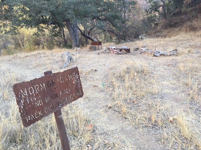


 Mormon Camp Survey - 02-16-2024 - by Los Padres Forest Association
| Link: | Mormon Camp |
| Date: | 02-16-2024 |
| Surveyor Name: | Los Padres Forest Association |
| Camp Description: | Mormon looked great! Biggest issue is that the winter 2023 storms took out some of the bench on the up-canyon side of the camp. As a result it's about a 8-10ft sheer drop into the river where the trail ramp used to be. People are now going downstream about 30yards and dropping in there, no big deal but certainly a large change to the camp. Someone had left a pair of womens hiking boots and an empty whiskey bottle, both need to be hauled out at some point. |
| Water Source: | Flowing |
| Water Source Details: | Winter 2024 = lots of water! |
| Weather Conditions: | |
| Images: | Looking up-canyon from the Mormon bench, hard to see the new drop into the river but here it is! Also the boots and trash are in the photo under the oak tree. |
Mormon Camp Survey - 09-10-2023 - by Peter Parziale| Link: | Mormon Camp |
| Date: | 09-10-2023 |
| Surveyor Name: | Peter Parziale |
| Camp Description: | The trail on the plateau from Manzana Schoolhouse is in good shape. Descending from the mesa, the trail was frequently washed out by the high waters from the winter rains. Previous hikers had built rock cairns/ducks especially at the places the trail crossed the water and our leader Doug used orange ribbon to flag the trickiest parts. The trail at Mormon Camp basically goes off a 10-foot ledge, all washed out. A team member cut out a step or two, but it's not a permanent improvement. The trail needs a lot of trail maintenance that to bring it up to stock-level. |
| Water Source: | Flowing |
| Water Source Details: | The winter rains continue to fill the stream. |
| Weather Conditions: | Hot and sunny |
Mormon Camp Survey - 04-23-2023 - by Matt Inman - Ojai Valley School| Link: | Mormon Camp |
| Date: | 04-23-2023 |
| Surveyor Name: | Matt Inman - Ojai Valley School |
| Camp Description: | Tons of shade here at Mormon. Just a little west is the beautiful Lorna Camp which is a real gem. |
| Water Source: | Flowing |
| Water Source Details: | |
| Weather Conditions: |
Mormon Camp Survey - 02-04-2022 - by Stephen S| Link: | Mormon Camp |
| Date: | 02-04-2022 |
| Surveyor Name: | Stephen S |
| Camp Description: | |
| Water Source: | Flowing |
| Water Source Details: | |
| Weather Conditions: |
Mormon Camp Survey - 03-21-2021 - by Jeremy K| Link: | Mormon Camp |
| Date: | 03-21-2021 |
| Surveyor Name: | Jeremy K |
| Camp Description: | |
| Water Source: | Flowing |
| Water Source Details: | Good Water Flow |
| Weather Conditions: |
Mormon Camp Survey - 01-12-2021 - by Easy-A| Link: | Mormon Camp |
| Date: | 01-12-2021 |
| Surveyor Name: | Easy-A |
| Camp Description: | |
| Water Source: | Trickle |
| Water Source Details: | Low flow but not stagnant. |
| Weather Conditions: |
Mormon Camp Survey - 01-01-2021 - by Shaddus Maximus | Link: | Mormon Camp |
| Date: | 01-01-2021 |
| Surveyor Name: | Shaddus Maximus |
| Camp Description: | |
| Water Source: | Trickle |
| Water Source Details: | Big, clear pools of water at Mormon. |
| Weather Conditions: |
Mormon Camp Survey - 12-11-2020 - by Steve Cypher| Link: | Mormon Camp |
| Date: | 12-11-2020 |
| Surveyor Name: | Steve Cypher |
| Camp Description: | |
| Water Source: | Flowing |
| Water Source Details: | Good water from here to Water Canyon. |
| Weather Conditions: |
Mormon Camp Survey - 05-16-2020 - by Addison Jerlow| Link: | Mormon Camp |
| Date: | 05-16-2020 |
| Surveyor Name: | Addison Jerlow |
| Camp Description: | pretty overgrown with grass at present. good for one tent. |
| Water Source: | Flowing |
| Water Source Details: | flowing well just down the trail from camp. 1-2ft deep |
| Weather Conditions: | |
| Images: | |
Mormon Camp Survey - 01-01-2020 - by Shaddus Maximus | Link: | Mormon Camp |
| Date: | 01-01-2020 |
| Surveyor Name: | Shaddus Maximus |
| Camp Description: | |
| Water Source: | Flowing |
| Water Source Details: | |
| Weather Conditions: |
Mormon Camp Survey - 11-25-2019 - by Paul Cronshaw| Link: | Mormon Camp |
| Date: | 11-25-2019 |
| Surveyor Name: | Paul Cronshaw |
| Camp Description: | This campsite is located on a bench above the Sisquoc. There are two Klamath stoves at this campsite; one of them is used as a table. |
| Water Source: | Flowing |
| Water Source Details: | Clean, flowing water with shallow pools |
| Weather Conditions: | 70s and Sunny |
| Images: | Sisquoc River at Campsite Nearby settler ruins Nearby settler ruins Nearby settler ruins |
Mormon Camp Survey - 05-21-2019 - by Los Padres Forest Association| Link: | Mormon Camp |
| Date: | 05-21-2019 |
| Surveyor Name: | Los Padres Forest Association |
| Camp Description: | LPFA trail survey along the Sisquoc between the Schoolhouse and just above Miller Camp. Water found at all crossings due to large 2018-2919 winter season. Mormon Camp was in good shape. |
| Water Source: | Flowing |
| Water Source Details: | Good water along the entire Sisquoc |
| Weather Conditions: | |
| Images: | |
Mormon Camp Survey - 04-01-2019 - by M Schless| Link: | Mormon Camp |
| Date: | 04-01-2019 |
| Surveyor Name: | M Schless |
| Camp Description: | |
| Water Source: | Flowing |
| Water Source Details: | Sisqoc flowing steady |
| Weather Conditions: |
Mormon Camp Survey - 04-22-2018 - by Matt Inman-Ojai Valley School| Link: | Mormon Camp |
| Date: | 04-22-2018 |
| Surveyor Name: | Matt Inman-Ojai Valley School |
| Camp Description: | Nice trail camp with shade. LPFA has worked the trail in this area and it is in good shape. |
| Water Source: | Flowing |
| Water Source Details: | Solid flow here approx. 6" deep. Some small pools |
| Weather Conditions: |
Mormon Camp Survey - 01-14-2018 - by Los Padres Forest Association| Link: | Mormon Camp |
| Date: | 01-14-2018 |
| Surveyor Name: | Los Padres Forest Association |
| Camp Description: | Mormon Camp Could use some new bolts to reattach the sign to the post.  |
| Water Source: | Flowing |
| Water Source Details: | Didn't see the usual beaver dams but good water at camp |
| Weather Conditions: | |
| Images: | |
Mormon Camp Survey - 04-02-2016 - by Katie Mendenhall| Link: | Mormon Camp |
| Date: | 04-02-2016 |
| Surveyor Name: | Katie Mendenhall |
| Camp Description: | Great spot for camping! |
| Water Source: | Flowing |
| Water Source Details: | Sisquoc River had lots of water. |
| Weather Conditions: | |
| Images: | The campsite Nearby farm ruins from the settlers Nearby farm equipment from the settlers |
Mormon Camp Survey - 05-06-2015 - by James Wapotich| Link: | Mormon Camp |
| Date: | 05-06-2015 |
| Surveyor Name: | James Wapotich |
| Camp Description: | Although the camp is right along the trail, it is located near a creek crossing along a scenic stretch of the Sisquoc. the camp has two grated stoves and fire ring. |
| Water Source: | Flowing |
| Water Source Details: | There is decent water a Mormon. Slow moving at the beaver dam, but good water just downstream. |
| Weather Conditions: |
 Survey / Report Form