 Use Marker Groups
 Wolf 2002
Piru 2003
Day 2006
Zaca 2007
Gap 2008
La Brea 2009

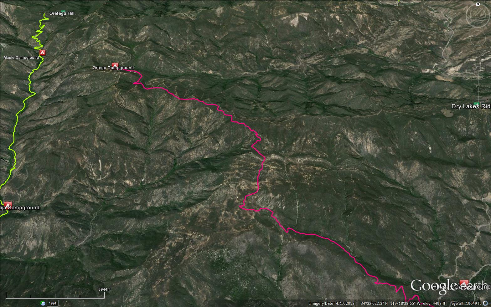
Ortega Trail is maintained by the "Ojai Valley Dirt Riders" a motorcycle club that was founded and organized for the sole purpose of keeping Ortega Trail open year round for the adventurous riders who enjoy it's many challenges. We have since branched out to help with OHV trail maintenance in other areas of the Los Padres National Forest. From the South the Ortega Trailhead is 1.5 miles north of Wheelers Campground/Visitor Center on Hwy 33. This single track motorcycle trail is 6 miles long (up to the Ortega Camp Site) and has sections that are very steep, rough and rocky making it very deserving of it's black diamond (advanced rider only) status. Beyond the Ortega Camp Site the remaining 3 miles of trail is an old jeep road that is currently only open to motorcycles and should be Ok for intermediate level riders who would need to access the trail from the North Trailhead via Cherry Canyon Road (3 miles long). The North Ortega Trailhead is at the end of Cherry Canyon Road. Cherry Canyon Road is off of Hwy 33 just South of the old Pine Mountain Inn. Ortega Camp is a remote rustic camp site that has 5 metal fire rings and 2 picnic tables but one of two tables is in very bad shape and not of much use.
The trail and camp are open and useable at this time.
Intersecting hiking trails: Dry Lakes Ridge Trail and Matilija Canyon Trail.
Written by Phil Pulley on 8-8-2015 - Please visit Ojai Valley Dirt Riders for more information
Historical Information:
Named for Jose F. Ortega who, in 1895 filed a 80 acre homestead claim from the state in Section 16 at the mouth of the canyon. Near what was known as Flat on Slide Rock at a big pool in Matilija Creek, he built a frame house that was later burned in one of the frequent brush fires of the region. In the winter season, when high water made travel difficult on Trail 23 W07 up the Upper North Fork of Matilija Creek, travelers used the dry country and Ortega Hill Trail 23WO8 as a bypass trail. From Cherry Creek road, the old Gas Pipe Line Road is open in season for jeep travel. Beyond a point south east of Ortega Hill it becomes OHV Motorcycle Trail 23W08.
Elevation: 2249 ft. to 4974 ft.


 Ortega OHV Trail Survey - 01-25-2025 - by Matt
| Link: | Ortega OHV Trail |
| Date: | 01-25-2025 |
| Surveyor Name: | Matt |
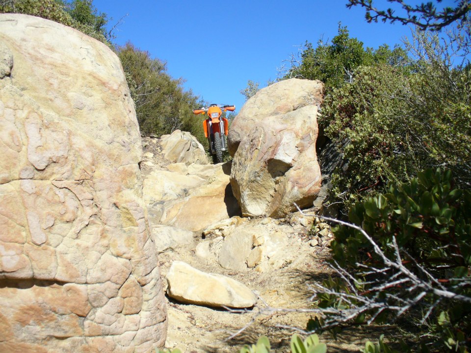
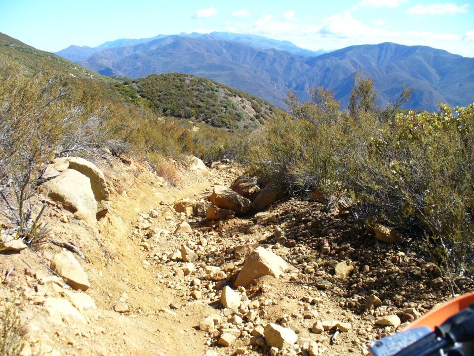
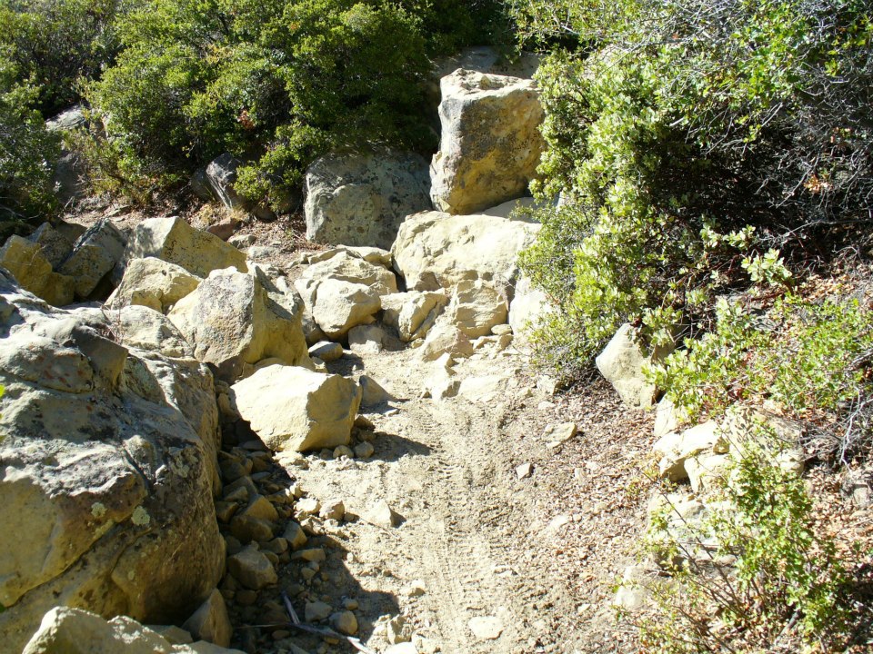
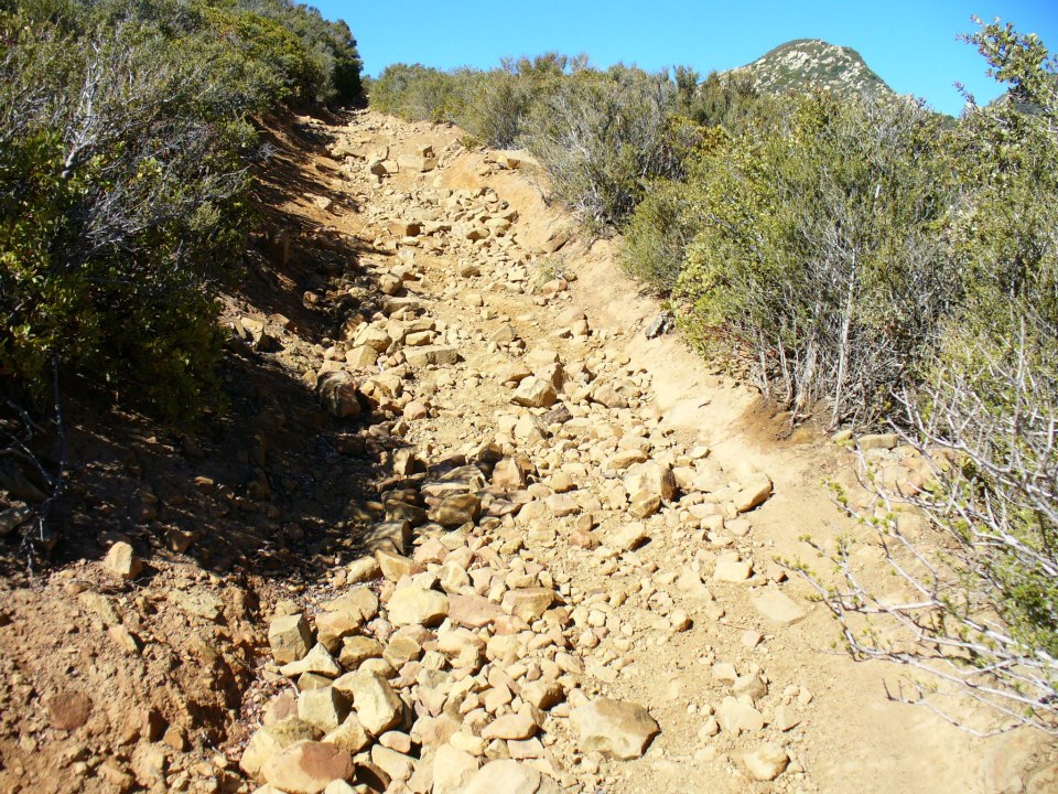
| Trail description: | I live in Ojai and have ridden this trail off and on for 30 years. As veteran of Tour of Idaho single track, as well as annual trips down Piru Creek, Snowy, Tinta, Disneyland, Toad, Sheep, and other stealth routes in Lockwood, I can report that It used to be a challenging but passable trail. Unfortunately, at this point the Ortega Trail is only suitable for hard enduro or trials riders due to the terrible erosion and 5-10' high boulder fields that have been left unmaintained. Unless you have no regard for the condition of your bike and plan to ghost your bike up these big ledges, the trail should only be tackled in groups of three or more riders with plans of regular spotting, lifting, hauling, pushing and pulling to overcome obstacles. There are sections of this trail that are still in great shape and fun to ride, but I have to be honest say that the route is a total mess. My son and I rode it from Hwy 33 to Hwy 33 on 1/25//25, and loved the scenery, but were bummed that the Ortega Trail has decomposed to this extent. |
| Mode of transport: | Array |
| Trail condition: | Needs some work |
| Condition details: | Hard Enduro or Trials Only |
Ortega OHV Trail Survey - 12-02-2023 - by Andy| Link: | Ortega OHV Trail |
| Date: | 12-02-2023 |
| Surveyor Name: | Andy |
| Trail description: | Trail is in fine shape, easy to follow no wash outs, no overgrowth. The tread is rocky and generally unpleasant to hike on, but I think that's typical for this trail. Trail is fully exposed, no shade, but good views all the way to Anacapa. |
| Mode of transport: | Hike |
| Trail condition: | Good shape and easy to follow |
Ortega OHV Trail Survey - 04-10-2021 - by Luna| Link: | Ortega OHV Trail |
| Date: | 04-10-2021 |
| Surveyor Name: | Luna |
| Trail description: | Hiked the first 2.5ish miles from the 33. Someone did a great job clearing brush, the trail is wide open. Lots of loose rocks and dirt on the trail, as expected for an OHV route. Could hear water in the creek, but there is no access. Decent amount of wild flowers. Extremely exposed with exactly 2 spots of real shade. I highly advise against bringing a dog outside of winter or overcast conditions. Even in early April with a fit dog with white hair, it was a struggle from both sun exposure and the hot ground. Will come back in the winter. |
| Mode of transport: | Hike |
| Trail condition: | Good shape and easy to follow |
Ortega OHV Trail Survey - 02-06-2020 - by Sean| Link: | Ortega OHV Trail |
| Date: | 02-06-2020 |
| Surveyor Name: | Sean |
| Trail description: | This trail needs YEARS of maintenance.  |
| Mode of transport: | O.H.V. |
| Trail condition: | Needs some work |
| Condition details: | Horrible OHV trail |
| Images: | Before After One of the many boulder fields |
Ortega OHV Trail Survey - 11-12-2018 - by Beth Pfeiler| Link: | Ortega OHV Trail |
| Date: | 11-12-2018 |
| Surveyor Name: | Beth Pfeiler |
| Trail description: | One week project with Ojai Valley Dirt Riders and United Trail Maintainers of CA volunteers. New culvert installed and storm damage repaired. Brushing.... Trail is in good condition. |
| Mode of transport: | O.H.V. |
| Trail condition: | Good shape and easy to follow |
Ortega OHV Trail Survey - 12-26-2016 - by EH| Link: | Ortega OHV Trail |
| Date: | 12-26-2016 |
| Surveyor Name: | EH |
| Trail description: | Rode the trail yesterday. Trail is in good shape. There are lots of loose rocks, but that is normal for this trail. The bushes in the forrest section (mile ~1 to ~2) seemed adequately trimmed, and caused no hindrance. There was no wash-out of the trail from the rain storm on 12/23/16 and 12/24/16. All the rocky sections had dried up sufficiently for the tires to get good traction while going up them. The last few hills before the campground (6 miles in) was covered with snow. Also, most of the trail section from the campground to the intersection with Cherry Creek Rd (mile 6 to 9) was snow covered. Cherry Creek Rd is currently closed, so you have to ride back down the same way. Regarding seasonal closure of this trail: I called the Ojai Ranger district office and they confirmed that this trail does not close seasonally. They might close it if a storm washes out the trail, but then it will be posted at the trail-head. |
| Mode of transport: | O.H.V. |
| Trail condition: | Good shape and easy to follow |
Ortega OHV Trail Survey - 08-08-2015 - by Phil Pulley| Link: | Ortega OHV Trail |
| Date: | 08-08-2015 |
| Surveyor Name: | Phil Pulley |
| Trail description: | Ortega Trail is maintained by the "Ojai Valley Dirt Riders" a motorcycle club that was founded and organized for the sole purpose of keeping Ortega Trail open year round for the adventurous riders who enjoy it's many challenges. We have since branched out to help with OHV trail maintenance in other areas of the Los Padres National Forest. From the South the Ortega Trailhead is 1.5 miles north of Wheelers Campground/Visitor Center on Hwy 33. This single track motorcycle trail is 6 miles long (up to the Ortega Camp Site) and has sections that are very steep, rough and rocky making it very deserving of it's black diamond (advanced rider only) status. Beyond the Ortega Camp Site the remaining 3 miles of trail is an old jeep road that is currently only open to motorcycles and should be Ok for intermediate level riders who would need to access the trail from the North Trailhead via Cherry Canyon Road (3 miles long).  The North Ortega Trailhead is at the end of Cherry Canyon Road.  Cherry Canyon Road is off of Hwy 33 just South of the old Pine Mountain Inn.  Ortega Camp is a remote rustic camp site that has 5 metal fire rings and 2 picnic tables but one of two tables is in very bad shape and not of much use.  The trail and camp are open and useable at this time. Intersecting hiking trails: Dry Lakes Ridge Trail and Matilija Canyon Trail. |
| Mode of transport: | O.H.V. |
| Trail condition: | Good shape and easy to follow |
| Images: | |
 Survey / Report Form - Please click this box to open the form.