 Use Marker Groups
 Wolf 2002
Piru 2003
Day 2006
Zaca 2007
Gap 2008
La Brea 2009

There are efforts underway to build a new trail up Matilija Canyon called the Matilija Falls Trail. Stay tuned and email INFO@LPForest.org for more information.


 Matilija Canyon Trail Survey - 12-10-2022 - by Andy M
| Link: | Matilija Canyon Trail |
| Date: | 12-10-2022 |
| Surveyor Name: | Andy M |
| Trail description: | First 2 miles are current and former roads, then it is a matter of following dry creekbeds and eventually the canyon. There is an intact trail the whole way, albeit sometimes hard to follow. Look for the cairns! A few unofficial campsites can be found after the 2 mile mark, when the trail is past the last house and orchard. Clear, attractive, and accurate signs are also a big improvement. |
| Mode of transport: | Hike |
| Trail condition: | Good shape and easy to follow |
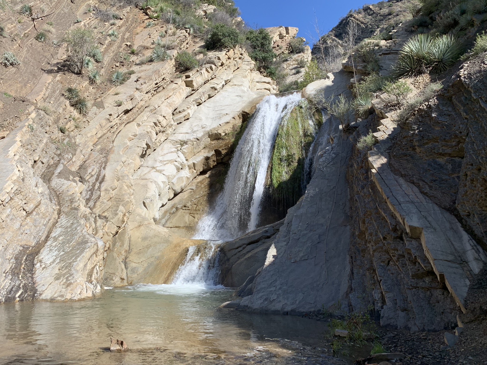
| Images: | Matilija Falls December 2022 |
Matilija Canyon Trail Survey - 03-29-2022 - by Addison Jerlow| Link: | Matilija Canyon Trail |
| Date: | 03-29-2022 |
| Surveyor Name: | Addison Jerlow |
| Trail description: | |
| Mode of transport: | Hike |
| Trail condition: | Good shape and easy to follow |
Matilija Canyon Trail Survey - 02-21-2022 - by AC| Link: | Matilija Canyon Trail |
| Date: | 02-21-2022 |
| Surveyor Name: | AC |
| Trail description: | Thank you LPFA for enabling this wonderful outing. The trail was clear and easy to follow. Flowers are blooming and the place was gorgeous! Plenty of water in the creek and lovely camp site. |
| Mode of transport: | Hike |
| Trail condition: | Good shape and easy to follow |
Matilija Canyon Trail Survey - 03-28-2020 - by Christopher P. Lord| Link: | Matilija Canyon Trail |
| Date: | 03-28-2020 |
| Surveyor Name: | Christopher P. Lord |
| Trail description: | First 3.8 miles of trail is in great shape after that it becomes a rock hop up Canyon. Swift water have the falls gushing. Perfect time to get up there. Much more detail at the blog link below. |
| Mode of transport: | Hike |
| Trail condition: | Good shape and easy to follow |
| Images: | |
Matilija Canyon Trail Survey - 07-20-2019 - by C Goodyear| Link: | Matilija Canyon Trail |
| Date: | 07-20-2019 |
| Surveyor Name: | C Goodyear |
| Trail description: | There's lots of conflicting/incomplete info about trails in Matilija out there, so I'll try to be as clear as possible. Matilija Canyon Trail IS OPEN and accessible, but the first couple miles follow a road cutting through private lands. (I met one of the owners at the gate, she confirmed that.) It's critical that you respect the land and their property in turn! Don't litter (even food waste), pick up after your animals, and don't stray from the road or you'll be trespassing. This trail definitely ranks as moderate-to-hard. It's long, about 11 miles round-trip to the third falls and back, and while it's open, easy to follow, and well-marked for the first several miles, it turns into scrambling and canyoneering for the last stretch. It's also about 1,600 feet net elevation gain with some ups and downs in the middle. I started at 1:00 pm on a mid-July day; the heat was tough and shade was only intermittent until I hit the deep canyons in the late afternoon. I drained a whole gallon of water by the end of the hike. To start, follow Forest Route 5N13 for just under a mile past the gate at the trail head. There at the first fork, follow the "All Trails" sign in front of the boulder pointing to the left. A few hundred yards past that, there's a peculiar forest service trail sign; it says "NO TRAIL," with "NO" crossed out, and an arrow in the middle points "All U.S.F.S Roads + Trails" to the left again. Ignore that and go right, through the walk-in entrance on the wooden gate just around the bend. Again, this is private land; do not leave the road or cross any stone walls or gates. Follow this road for just over a mile until you get to another creek crossing at the intersection of Old Man Canyon (west) and Matilija Canyon (north). The creek crossing is well marked with stone stacks. On the opposite (north) creek side, the trail picks up again behind a couple pieces of concrete pipe piled on the bank. At this point, the trail climbs over the hills to the west of Matilija creek for about a mile. (The climb is a lot easier than navigating the rocky creek bottom, but that's another option). As the mountains to the sides get higher and steeper, the trail eventually switchbacks down to the creek bed and crosses to the east side. From here, the trail is well marked with flags and stone stacks, but it starts to turn rockier and rougher. The first big waterfall is a little under a mile up the creek from there; it's a 10-12 footer dropping into a pool that would be swimmable, were it not for all the green scum growing on it this time of year. There's a very easy step-climb around it on the rocks to the right; just be careful if they're wet. From this point, the trail is just best-guess canyoneering with few rock stack markers here and there. Several hundred feet past the first falls, there's another fork in a deep canyon; the second waterfall is just up to the left. Its big drop is about 50-60 feet into a pool that's only 2-3 feet at most, so it's a great spot for a cool-down shower break. Finally, the third waterfall is about another third of a mile up the canyon to the right from that fork. This was some of the hardest going on the whole hike; lots of scrambling over rocks, across the creek, and around brush. It's worth it though; this one is about a 30-40 foot total drop with a cave behind it, and again would be a great swimming spot but for the algae scum. I've read you can climb past these falls to continue up the canyon, and there was in fact a rope running about halfway up the rocks to the right of the falls, but it looked super-sketchy. I made it to the third falls from the trail head in about four hours, moving at a pretty steady pace with only the one significant break at the second falls. My GPS read 5.5 miles when I finally turned around, and the trip out was only about three hours. Lots of fun, but real tough and rugged toward the end; it would definitely be smart to bring a buddy next time. |
| Mode of transport: | Hike |
| Trail condition: | Good shape and easy to follow |
| Images: | Weird sign at the second fork - go RIGHT, then through the walk-in fence to the ranch. STAY ON THE ROAD! Creek crossing at the intersection of Old Man & Matilija Canyons. Note the two concrete pipes to the left where the triail picks up on the other side. First waterfall! Walk up the wet rocks to the left to get past it. Second waterfall! Take a sublime trail-shower under that bad boy. Third waterfall! Looks like a good swimming hole and a fun cave to explore, if you have the time (I did not). |
Matilija Canyon Trail Survey - 05-28-2017 - by Andrew| Link: | Matilija Canyon Trail |
| Date: | 05-28-2017 |
| Surveyor Name: | Andrew |
| Trail description: | The trail was busy the Sunday of Memorial Day weekend. I encountered other hikers about once every 10-15 minutes.  There was a campground with fireplaces near where I turned around. I would estimate that I went about halfway down the trail before heading back because my hiking partner was overheating. There seems to be a lot of confusion about whether this "trail" is open to the public, but according to this article there is access as of this post. However, the signage is a little confusing, so I included pictures showing where to go. |
| Mode of transport: | Hike |
| Trail condition: | Good shape and easy to follow |
| Images: | This sign says that all trails go to the left up the hill. Your trail actually goes to the right towards the grove. Go through this gate and continue through the groves along the road and be respectful of the ranchers land. continue until the road narrows to a trail and keep going the stream was flowing, although there was a lot of green vegatation/algae along the bottom there are some nice views along this trail |
Matilija Canyon Trail Survey - 02-24-2017 - by Anonymous Surveyor| Link: | Matilija Canyon Trail |
| Date: | 02-24-2017 |
| Surveyor Name: | Anonymous Surveyor |
| Trail description: | The trail is open. The recent rains have made this an epic hike! |
| Mode of transport: | Hike |
| Trail condition: | Hard to follow |
| Images: | |
Matilija Canyon Trail Survey - 11-26-2016 - by Joe C| Link: | Matilija Canyon Trail |
| Date: | 11-26-2016 |
| Surveyor Name: | Joe C |
| Trail description: | Open access once again. Day hike from N. Fork Matilija/Murrietta trailhead to Matilija falls. Nice to see some creeks and pools on the way to the falls with decent flow. Trail was in great shape until about 2 miles from first falls. Thanks to the spray paint and cairn help, whomever! |
| Mode of transport: | Hike |
| Trail condition: | Good shape and easy to follow |
 Survey / Report Form - Please click this box to open the form.