 Use Marker Groups
 Wolf 2002
Piru 2003
Day 2006
Zaca 2007
Gap 2008
La Brea 2009

Geography
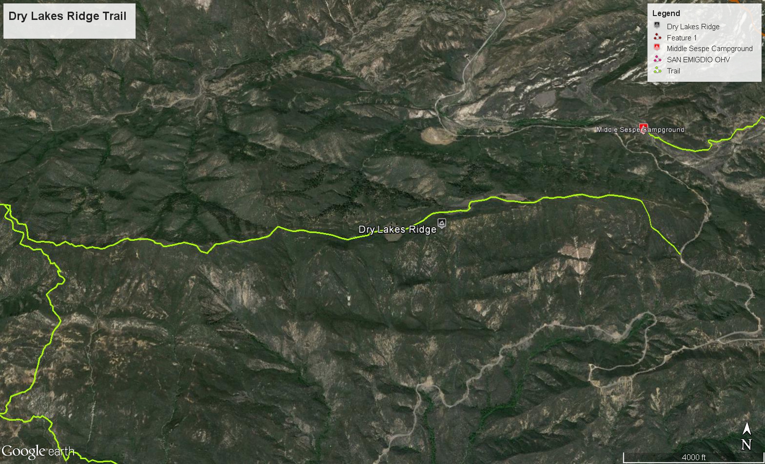
Dry Lakes Ridge is located in northern Ventura County, and entirely within the Los Padres National Forest. Dry Lakes Ridge is a east-west-trending range, as are all the mountains within the Transverse Ranges. It is bounded on the north by Sespe Creek and Tule Creek (a tributary to the Sespe), both of which follow the Tule Fault, North Fork Matilija Creek and Pollard Point on the south and southeast, Howard Creek on the east, and Ortega Hill on the west. Dry Lakes Ridge occupies approximately 10,018 acres (4,054 hectares). Sespe Creek and Tule Creek drain the north slope of the ridge and the North Fork Matilija Creek drains the south slope. Native plants and scenes of Dry Lakes Ridge are featured on this website.
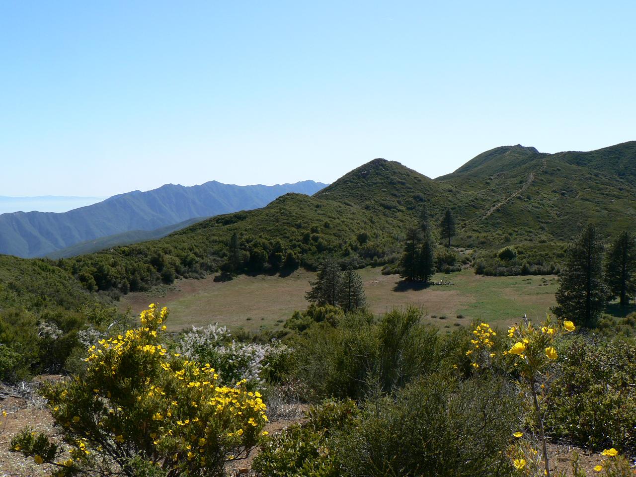
A U.S. Forest Service fire break provides access to the top of the ridge, connecting Ortega Hill with State Route 33 (SR33) at the east end of the ridge. The highest point on Dry Lakes Ridge is 4,850 feet elevation. The ridgetop is accessed by the fire break, from either Ortega Hill (a long hike) or SR33 on the east. The main geographic feature of Dry Lakes Ridge is the summit basins, which are not, and never were, lakes; rather, the basins are fault-related features, where the rock has been ground up from successive movement of thrust faults.
Botanical Area
The ridgetop has been designated as a Botanical Area by the Los Padres National Forest, Dry Lakes Ridge Botanical Area, occupying 399.1-acres (161.5-hectares) of the ridge. The U.S. Forest Service based its decision to designate the ridgetop as a sensitive area in large part because of my research of the ridge's floristics, and publication of A Flora of Dry Lakes Ridge, Ventura County, California in 1986, through the University of California, Santa Barbara Herbarium. This publication, available for purchase through the California Native Plant Society, Channel Islands Chapter, includes a detailed description of the natural and human history of the ridge, as well as an annotated catalogue of all the vascular plants found during the two-year study between 1984 and 1985. The summit basins contain a relictual stand of Ponderosa Pine, associated with Great Basin Sagebrush Scrub, surrounded by different types of chaparral.
David L. Magney. "Dry Lakes Ridge, Ventura County, California" magney.org. blog, Feb. 21. 2008. Web. Dec. 16. 2014. <http://www.magney.org/photofiles/DryLakesRidge.htm>


 Dry Lakes Ridge Trail Survey - 02-16-2024 - by bardley
| Link: | Dry Lakes Ridge Trail |
| Date: | 02-16-2024 |
| Surveyor Name: | bardley |
| Trail description: |
If you like hiking on steep trails (1000’ gain in about a mile) – this hike is for you. If you like hiking on marbles – this hike is for you. If you like hiking on small rocks - this trail is for you. If you like hiking in tiny gullies – this trail is for you. If you like hiking where each step must be contemplated before execution – this hike is for you. If you like hiking in dormant poodle dog bush – this hike is for you. If bushwhacking is your middle name - this trail is for you. If going where most do not go – this trail is for you. |
| Mode of transport: | Hike |
| Trail condition: | Needs some work |
| Condition details: | Perfect weather day with perfect companions to visit this seldom visited place |
Dry Lakes Ridge Trail Survey - 04-23-2022 - by Jeyla Fendi| Link: | Dry Lakes Ridge Trail |
| Date: | 04-23-2022 |
| Surveyor Name: | Jeyla Fendi |
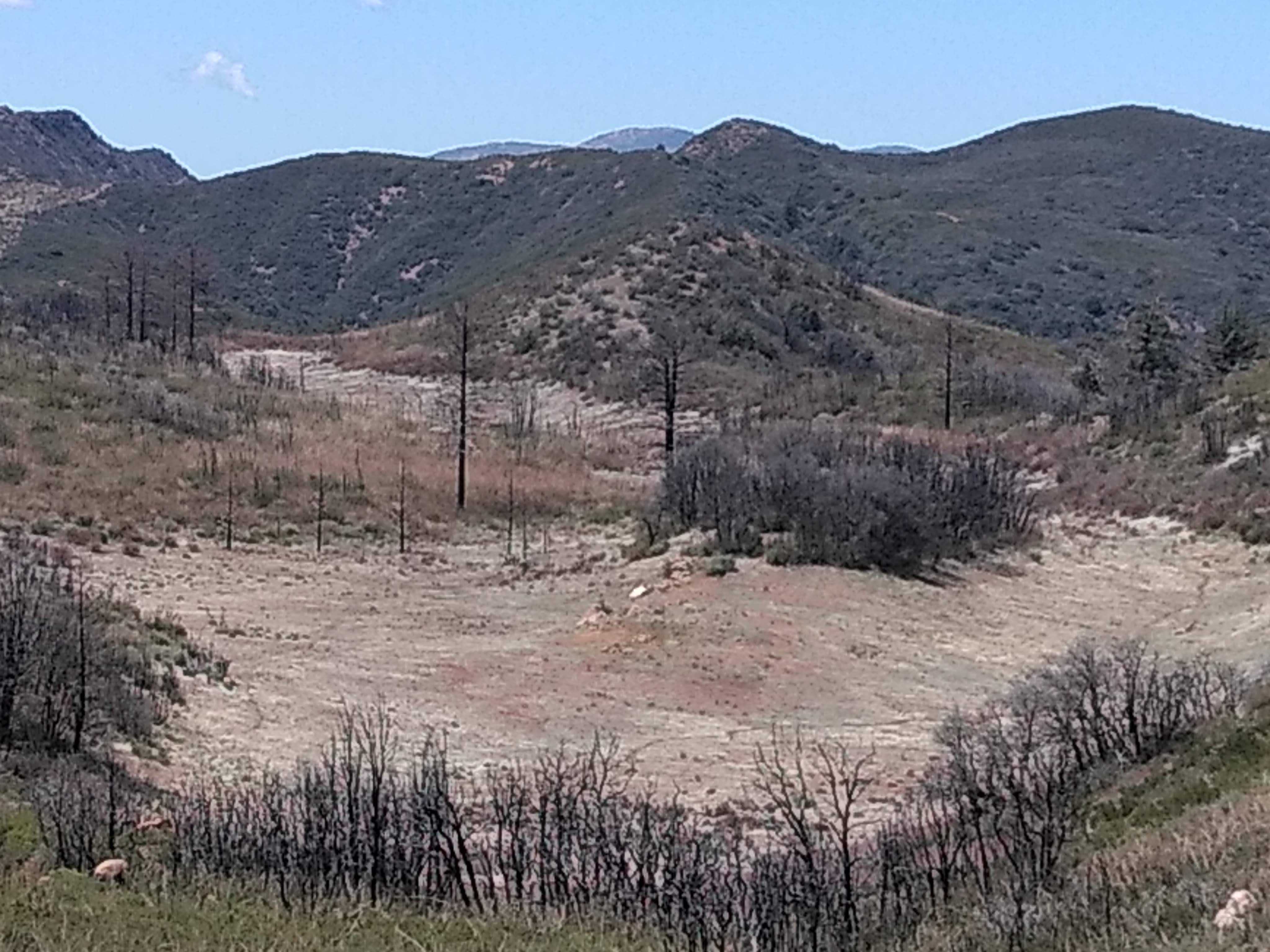
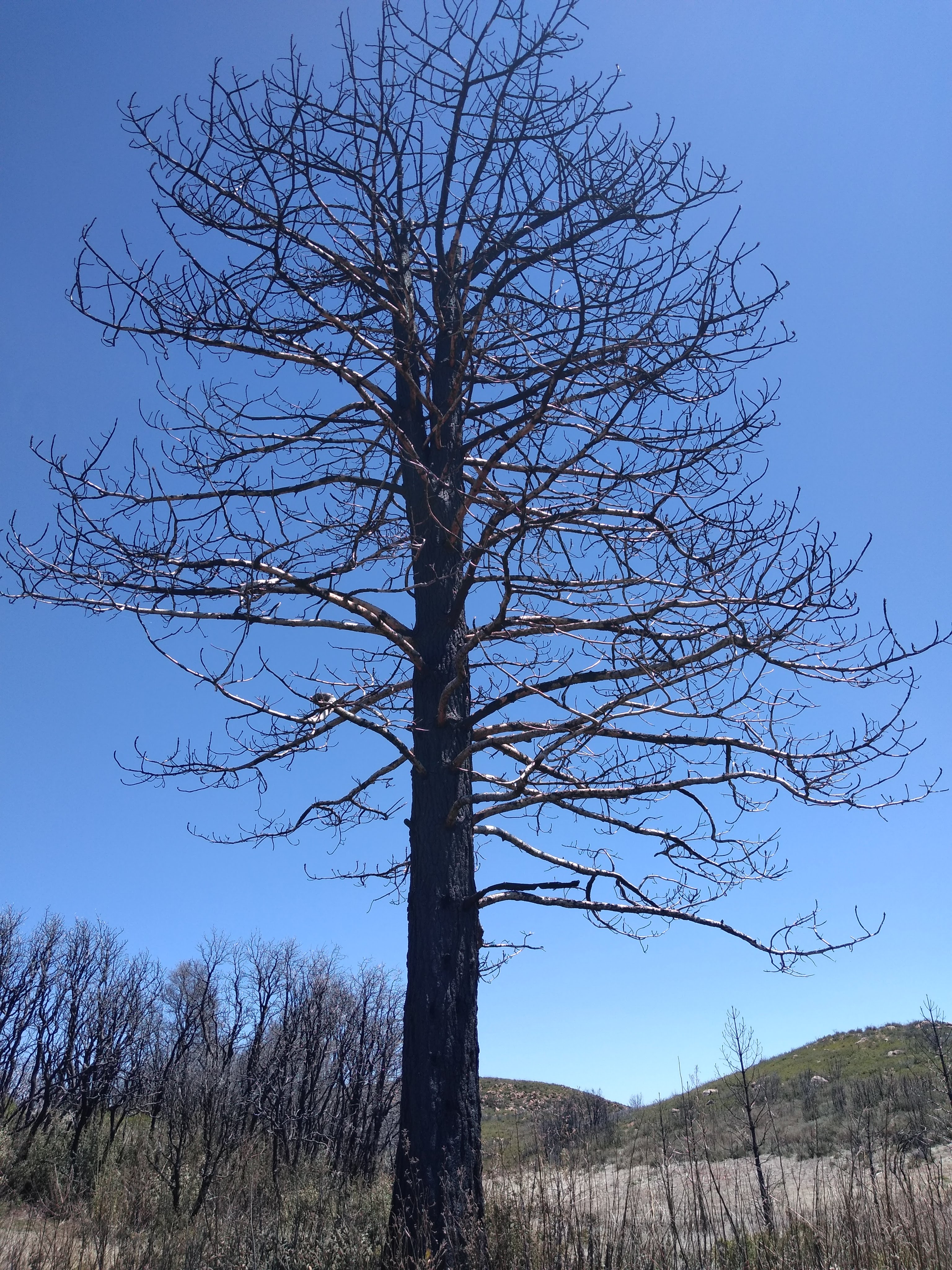
| Trail description: | The trail as of 04/23/22 is half maintained, half overgrown. The trail begins at the 33 (park at the turnout) and it's about a straight vertical ascent for the first mile or so. At the beginning the trail is very easy to follow and there will be plenty of chaparral wildflowers on the way up. As you start to level off along the ridge the terrain changes to a sky island of manzanita and ceanothus. This is will start to zigzag and eventually split off into multiple directions. As long as you maintain a general path up the ridge you won't get too lost. The views are stellar with the channel islands / pacific ocean to the left and piedra blanca / pine mountain to the right. After scaling the ridge for another mile or so you'll drop down into the lake vista. There are two giant main lakes and a third smaller lake farther out. Depending on the time of year and plant overgrowth, you are able to access all three. Poodle dog bush (Eriodictyon parryi) can be found all over the lakes and has giant beautiful blooms in the summer. However it is painful with dermatitis hairs and should be avoided when in bloom. As of today it had all died back and was dry which made traversing the paths doable. To access the lake hike all the way down through the chaparral corridor (the trail chokes out) until you find the path adjacent to the first lake. There are two main "deer trails" you can use to drop down into the lake. Enjoy a plush lupine filled field teaming with plant diversity. You can leave your pack on the center rock "island" and walk around to explore. The lakes also contain ancient ponderosa pines which have sadly burned to a crisp, but you can still read their numbered tags. After exploring take caution heading back up the trail. From this angle it is very easy to lose (despite hiking "down" it). The hardest part is crossing the manzanita sky island again, it can become confusing and you might often find yourself following erosion channels instead of the real path. All channels lead downward which is a good thing, with enough observation you should be able to connect back to the main trail. After the ridge it's quite easy to follow the path back down, but bring trekking poles or you will definitely slip! The entirety of this trail is exposed and high elevation, so mind the weather and UV radiation. The best times to hike it are in winter and late spring. If you can catch a June gloom that's good too, and gives a rare opportunity to hike above the marine layer. It feels like you're hiking in heaven! But it will be very hot. Bring a hat, a LOT of water, long sleeves and pants for bush-wacking, hiking poles, a good camera, and lots of snacks. The terrain is sandy and rugged so I recommend boots with ankle support. If you can brave it it's definitely worth the trek. Enjoy. |
| Mode of transport: | Hike |
| Trail condition: | Needs some work |
| Condition details: | Trail is have maintained, half overgrown. |
| Images: | View of the beginning of the trail, looking back. Entering the sky island of manzanita, mostly subspecies of A. glandulosa. The trail opens up after the manzanita crawl. Dropping down now, vista of the dry lakes. The ancient stands of ponderosa pine. |
 Survey / Report Form - Please click this box to open the form.