 Use Marker Groups
 Wolf 2002
Piru 2003
Day 2006
Zaca 2007
Gap 2008
La Brea 2009

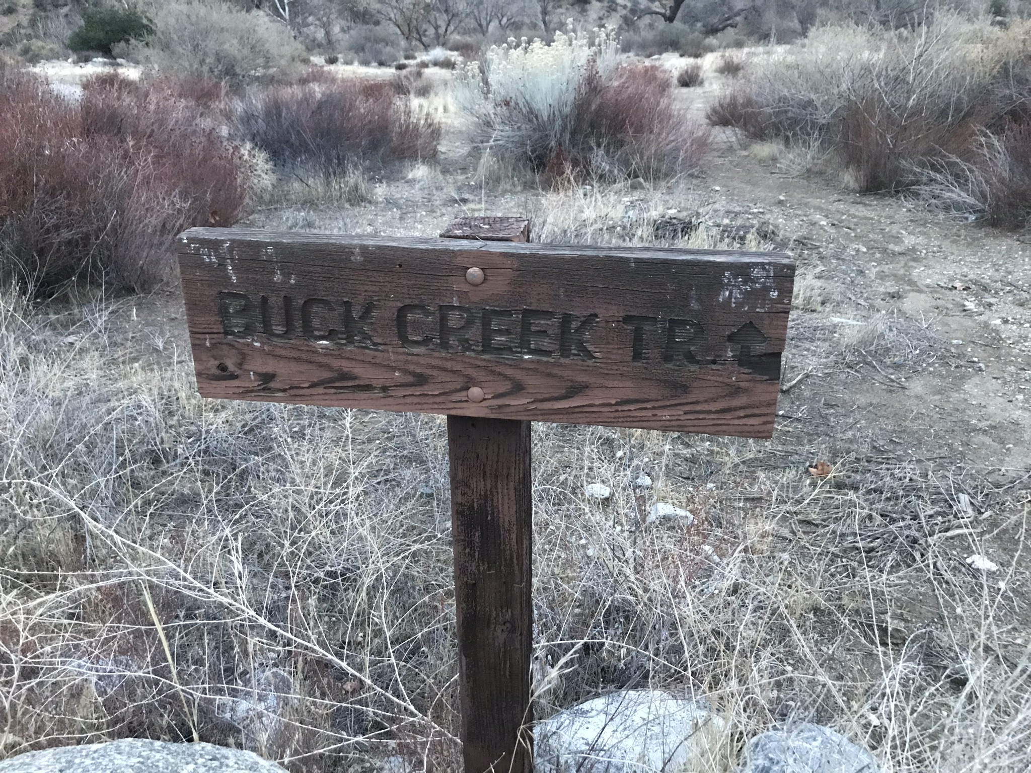
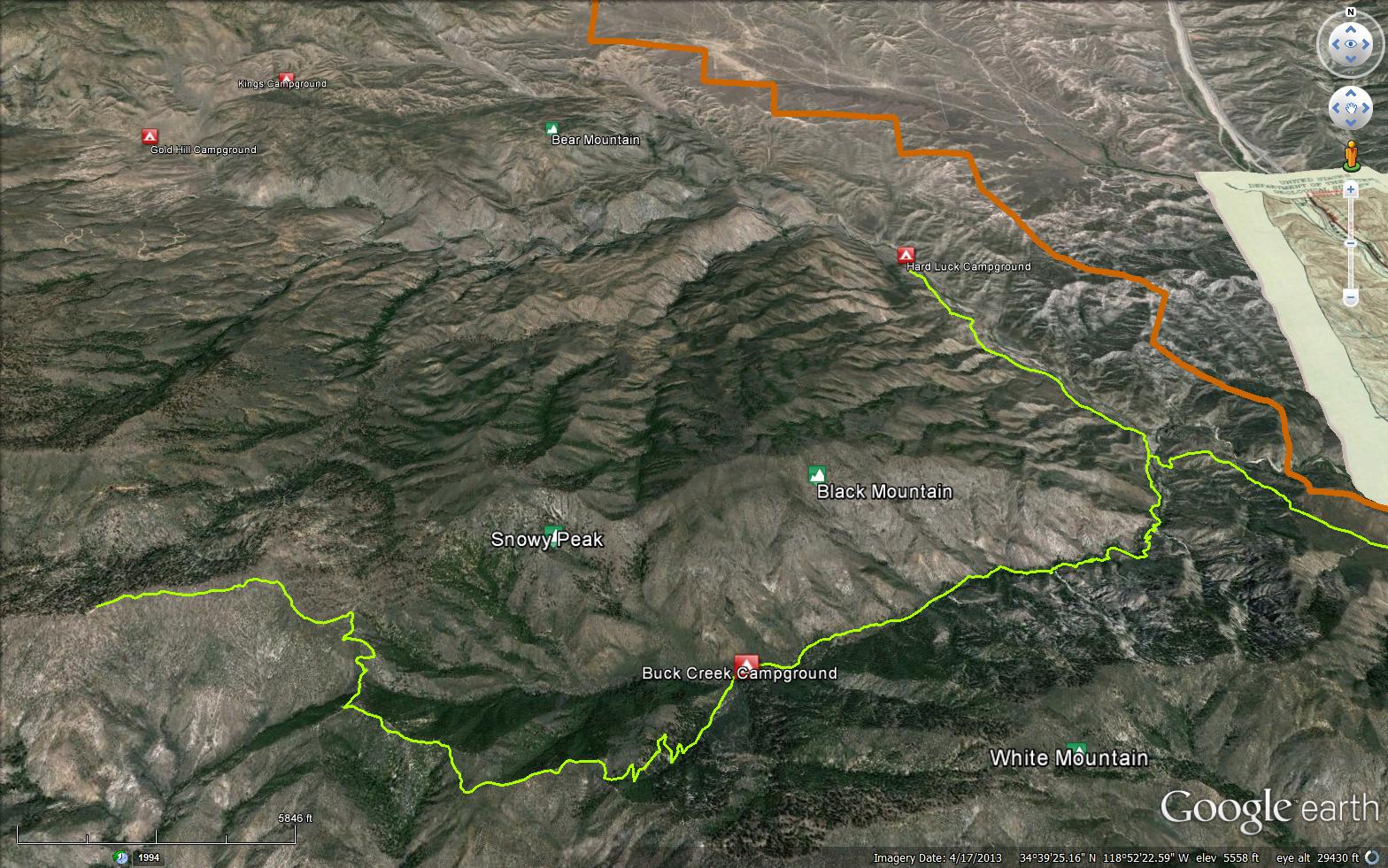
This trail begins at the old Hardluck Campground on Buck Creek Road and follows Piru Creek before eventually ascending to the ridge between Sewart Mountain and McDonald Peak. Though it is still possible to connect the two trailheads, most hikers don't make it past Buck Creek Camp as the trail has not been worked beyond it is many years. The trail begins to worsen in the half mile before camp. Although the trail has seen better days, spectacular views of the surrounding environment are awarded to the hardy outdoor enthusiast and steep canyons, dense stands of big cone douglas fir and rugged peaks await the those willing to work for them.
PLEASE NOTE: Buck Creek Road is PERMANANTLY CLOSED here 34.705354, -118.821098 at its junction with Hardluck Road. An extra 3.6 mile walk one-way is required to access the lower trailhead. The upper trailhead is accessed via Forest Road 8N01 and 6N10, both of which are high clearence 4WD recommended.
Buck Creek Camp (4200 feet)


.jpeg)

 Buck Creek Trail Survey - 05-27-2023 - by Oh Three
| Link: | Buck Creek Trail |
| Date: | 05-27-2023 |
| Surveyor Name: | Oh Three |
| Trail description: | This old backpacker is talking about this trail from the bottom, since the top is closed, I didn't try to go up Buck Creek; that's presumably all washed out! Piru Creek is FLOWING needless to say, although Piru Creek is now fast cold clear water as opposed to the fast cold brown mud of a couple months ago. The paved ford is the only wet stream crossing, the others are now dry channels, with Piru Creek rushing down the northeast side of the valley. I went in this past holiday weekend with tools to repair the "flying squirrel" (Los Padres' best "e ticket" ride, where Buck Creek meets Piru Creek) but someone beat me to it, and it was largely ready for use. (Thank you!) I did trim some more branches and added another tie rope. ... Enjoy the horned toad photos. I don't see those critters as much as I did a couple decades ago. They are real throw backs! |
| Mode of transport: | Hike |
| Trail condition: | Good shape and easy to follow |
| Images: | Today's Dinosaurs Find It! |
Buck Creek Trail Survey - 11-21-2021 - by Christopher P. Lord| Link: | Buck Creek Trail |
| Date: | 11-21-2021 |
| Surveyor Name: | Christopher P. Lord |
| Trail description: | From the upper Buck Creek Trailhead atop Sewart Mountain down to where I dropped off the ridge toward Borracho camp - N34.62667° W118.88875° was in excellent condition. Thanks in part to the large group of motorcycle enthusiasts armed with chainsaws as they push on toward Hardluck or wherever they are going. A dirty job but hey someone's got to do it. Not as if our hiking trails up there are gonna get any love the ethical way. More of the days events at the link below. https://christopherplord.blogspot.com/2021/11/back-to-borracho.html |
| Mode of transport: | Hike |
| Trail condition: | Good shape and easy to follow |
| Images: | Buck and Big Cedar Creek trail junction |
Buck Creek Trail Survey - 04-15-2021 - by Diane Soini| Link: | Buck Creek Trail |
| Date: | 04-15-2021 |
| Surveyor Name: | Diane Soini |
| Trail description: | I visited this trail in 2019 and this year it seems to be worse
off. There are more wild roses and vines that tangle you. Or maybe it is
that when the wild roses haven't leafed out yet they are harder to get
through. The trail is easy to follow from
Hardluck, but once you arrive at the first creek crossing, it becomes
more difficult. There are ducks to help you find your way to the initial
high trail into the canyon. This high trail has numerous very large
trees crashed over it. Once you reach the area
of white rocks tumbling from a side canyon, there is a little more high
trail and then it descends into the chaos of the creek permanently.
There is at times pink tape, bright red and yellow cloth tape and yellow
caution tape to help you out. Sometimes you have to understand that the
tape might be trying to inform someone who might be tangled below into
the area where you already are, and that you have to follow it
carefully. Eventually the tape ends, there may be a duck here and there
but mostly not, and you are left to hunt for the trail under fallen
trees. At times there are some nice cruisy sections of trail that let
you walk for quite some distance, but most of the time you wallow
tangled in the brush making very little forward progress. This
year I went two hours between the last water I saw and Buck Creek Camp
where the spring was dry. My GPS showed me right on the spot where the
spring should be, and I hunted around a bit, but there was nothing but
tangled vines and the smell of moisture. After Buck Creek Camp I
struggled to find the way forward, and since I was out of water, I
decided to turn back rather than try to get all the way up the mountain
and back down to Little Mutau creek. To
repair this trail would be a multi-year project. If this trail could be
repaired, it would allow for interesting loop opportunities. It is
possible to walk cross-country along Piru Creek between Hardluck and
Snowy Creek motorcycle trail. Snowy Creek motorcycle trail is in good
shape and easy to follow (with a lot of downed trees, but not as
impossible to get through as Buck Creek). Both Snowy Creek and Buck
Creek canyons are beautiful canyons, each with their own character. At
the top of both trails you are among the pantheon of high peaks that
form the roof of the Los Padres. It's really quite spectacular. Will
anyone show some love for the Eastern Los Padres? |
| Mode of transport: | Hike |
| Trail condition: | Non existent |
| Condition details: | While I was able to follow it, it really is non-existent at this point. |
| Images: | Large tree you must get through on the high trail. White rocks tumbling from a side canyon. There's a little more high trail after this. Much of the trail has you wallowing in wild roses and other vines. Sometimes the tape is telling you not to go this way. Much of the trail has you navigating your way through stuff like this. There's a fairly long section of good trail far into the canyon. Unfortunately it ends well before Buck Creek camp. |
Buck Creek Trail Survey - 12-04-2020 - by Jim Kenney| Link: | Buck Creek Trail |
| Date: | 12-04-2020 |
| Surveyor Name: | Jim Kenney |
| Trail description: | The trail from the trailhead is fairly east to follow. There are numerous tress that are across the trail, but they are fairly easy to get around. At the trail junction at the Snowy Peak trail is where the real fun begins. Besides not being marked and challenging to find the route for the first mile is over grown with Chaparral White Thorn, Yucca and i think some poodle bush. Body armor is strongly recommended as the white thorn cover the trail and is about 7 feet high. After being shredded for the first mile you reach the saddle. From there you can follow the old road bed. Ah, but you are not out of the woods. This is where the White Thorn and yucca gang up on you to slice and dice you as you bushwhack through them. Needless to say this trail needs some work. My guess is next year this trail will be not passable without aforementioned body armor, full helmet and gloves. Happy hiking! |
| Mode of transport: | Hike |
| Trail condition: | Hard to follow |
| Condition details: | Buck Creek trailhead from Alamo Mt. |
| Images: | |
Buck Creek Trail Survey - 10-30-2020 - by Jim Kenney| Link: | Buck Creek Trail |
| Date: | 10-30-2020 |
| Surveyor Name: | Jim Kenney |
| Trail description: | This will only be a short review. Leaving the camping area the trail is well marked and easy to follow. After you turn away from Piru creek there is a TON of poison oak encroaching the trail, be ready. There are also spots where the trail has sluffed away and careful footing is needed. There are numerous trees down and i will add coordinates in the description along with a photo. I used my trekking pole to give perspective. Between tree #2 and Tree #3 the trail has been completely was away and a 5 foot class 3 climb is needed to traverse. We chose a different way on the way back. At tree #4 the tree was covering the complete trail and the only way around was a stiff climb through poison oak. We chose to turn around. On the way back we crossed the creek at a cairn signed junction. This took us around the destroyed trail, but needs to be more clearly marked in order to return the hiker back to the established trail. |
| Mode of transport: | Hike |
| Trail condition: | Needs some work |
| Condition details: | Buck Creek from Hard Luck Camp |
| Images: | 34.65671, -118.82714 34.65476, -118.82781 34.65071, -118.83101 34.65041, -118.83091 34.64992, -118.83167 |
Buck Creek Trail Survey - 05-30-2020 - by Christopher P. Lord| Link: | Buck Creek Trail |
| Date: | 05-30-2020 |
| Surveyor Name: | Christopher P. Lord |
| Trail description: | Without reiterating my whole blog post here, please see the link below for updated trail information from the Upper Buck Creek Trail-head. |
| Mode of transport: | Hike |
| Trail condition: | Needs some work |
| Images: | |
Buck Creek Trail Survey - 05-21-2019 - by Diane Soini| Link: | Buck Creek Trail |
| Date: | 05-21-2019 |
| Surveyor Name: | Diane Soini |
| Trail description: | My previous trip report is probably a little inaccurate. I went down the trail from the top. I found the worst part of the trail to be the lower portion (although that's a relative statement--the entire trail is a mass of fallen trees). However, looking at Google Earth imagery again, it appears that perhaps I should have marked more of the visible trail in that lower portion of the trail. I can see visible trail on the western edge above the creek about 2/3 - 1/2 of the way down from the Guerilla Camp at the end of the long portion of "permanent" high trail. I think I may have stayed down in the creek too long and gotten mired in debris in the flood plain. I think now that were I to do this again with more waypoints made with Google Earth to point out visible portions of the trail, I would be able to find the way through the lower section of the trail much better. Perhaps this trail is still salvageable. Obviously people frequent the place since there are so many guerilla camps. Darn, I think this means I have to go back to Buck Creek someday. Why is there always some insane trail out there that haunts you? |
| Mode of transport: | Hike |
| Trail condition: | Hard to follow |
| Condition details: | Looking at Google Earth again, it appears I may have simply gone the wrong way... |
| Images: | Google Earth imagery - Green is trail I missed. |
Buck Creek Trail Survey - 05-12-2019 - by Diane Soini| Link: | Buck Creek Trail |
| Date: | 05-12-2019 |
| Surveyor Name: | Diane Soini |
| Trail description: | I started Buck Creek trail from Sewart mountain and made it to Hardluck. The trail is open very well up there with serpentine pathways through all the massive fallen dead trees and massive brushing and trail work. The area had been obviously devastated in a fire but it is easy enough to follow if you are observant. Near the summit of Sewart Mountain, it is easy to miss the turnoff to continue on the Buck Creek Trail. It is not marked and is easy to miss. You must turn right rather than continue along the more visible trail you are on. With a GPS you can avoid missing the turn. As the trail descends down toward White Mountain and Cobblestone, it is in very good shape and clear. Easy to follow. It appears it was once a dirt road. Where the trail is supposed to turn down into the Buck Creek Drainage itself it becomes a bit confused. You must seek out a small "dry lake" that is marked on the topo. The trail continues through at the other end of the dry lake. You have to push through a little bit of brush to find it. You will see some old oil cans and other metal debris. The trail thereafter is very faint. It is easily confused with bear trails. In fact, I probably missed a switchback and instead ended up following a bear trail too far. I ran out of daylight and had to bushwack to a flat spot marked on the topo so I could make camp (no fire, just sleep) for the night. In the morning I tried to return to the trail but instead of trying to find and follow it I simply bushwhacked straight down to the bottom of the canyon. There I found the trail again. It took determination to reach Buck Creek Spring. The trail is littered with fallen and tangled debris and brush. Near the spring I found an old camp. There were two signs in the camp but no longer is there any information visible on the signs. There were 2 large fire rings and some kind of stone wall or something. I believe that this is one of the "official" Buck Creek Camps. Depending on which map you have, there is a camp here at the spring or another one further down the canyon, both called Buck Creek Camp. The spring itself was sort of delightful although a bit hidden by water plants. You can find it because you can hear it burbling. From this upper Buck Creek camp I was able to follow intermittent trail and fight constant brush and blowdowns of all sorts of trees and all sizes. I had many waypoints marked on my GPS in advance to try to help me find the way. Occasionally there were ducks. After a long fight with brush, blowdowns, tangled masses of dead stuff, fern fields that I sunk into up to my waist, I found a guerilla camp someone had made with a little bench and fire pit. At this spot I think I did not attach my funny foam coolie-type hat properly to my pack and somewhere after this spot I lost it. If anyone dares try to hike here and you find my hat, please return it to me! After more fighting with constant blowdowns and brush, I found another Buck Creek Camp. This one is the one Chris Lord reported with pictures of what looks like an oven door and some other metal artifacts. At times I could find portions of trail that were fairly good. There was one long stretch where I made decent progress for perhaps half a mile. Someone also flagged portions of the middle trail with pink tape and yellow caution tape which I was able to follow now and then. But mostly I fought through tangles of stuff. Eventually I found the trail where it rises out of the creek at a confluence with a lot of bright whit boulders coming from a side canyon. This trail was in pretty good shape although there were a few fallen trees you can add to what was reported previously. All the blowdowns reported previously were still there and I found them all. You can times all of those by 5-10 and get a more accurate representation. After the section of high trail lowers down into the creek again, there is a large guerilla camp. The water in Buck Creek at this camp has to be some of the clearest looking water. Unfortunately, here is where the trail is completely obliterated. The area from this guerilla camp to the Piru confluence appears to have been devastated by a massive debris flow. There was tape and occasional ducks to follow but most of the time there was nothing at all to follow. At one point I decided to make a traverse from one side of the canyon to the other to see if I could follow the trail. I believe I did this somewhere around the vicinity of the old Bailey Trail. At one point my GPS told me I was on the Bailey Trail but there was nothing resembling a trail at all. At one point my GPS told me I was on Buck Creek trail but there was only total devastation as far as the eye could see. The entire canyon was just a pile of rocks and sticks and dead trees and devastation. I made my way to a bench on the west side of the canyon hoping to find trail up there but there was nothing. I had been here 10 years ago in the vicinity of the Bailey trail and recall a small gentle little creek you could easily hop across. It no longer looks like this. In total, I forced my way through the tangled debris flow for many hours until I finally reached the confluence. Overall, it took over 12 hours to hike something like the 5 or 6 miles from the dry lake to the confluence with the Piru. Once I reached the confluence, the old dirt road has now reverted into a single track trail. It is easy to follow. Overall I would say this trail is obliterated. It would take a revival of the WPA to bring it back. You couldn't bring it back with a couple of guys with folding saws, loppers and a cross-cut. It would take a team of people dedicated (and probably paid with real money). |
| Mode of transport: | Hike |
| Trail condition: | Non existent |
| Condition details: | One word: Obliterated |
Buck Creek Trail Survey - 04-07-2019 - by Oh Three| Link: | Buck Creek Trail |
| Date: | 04-07-2019 |
| Surveyor Name: | Oh Three |
| Trail description: | Following up on my 4/1/19 review, I went back and hiked to/from Piru Creek the next weekend, this April 6/7, and took the "shortcut" trail both ways. It cuts a mile and some elevation off from the paved road, but more importantly, it's much more "outdoors" and enjoyable than hiking on asphalt. The 1st 100 yards on each end require some route finding, but the bulk of the trail is an overgrown jeep trail, and quite easy to find/follow. I *thought* the shortcut trail was a secret. I first heard of it in Valerie Norton's blog, I think, with its excellent Los Padres hike (dirt) descriptions, and its excellent art (ink), then when I posted my comments last week, Chris Lord, another detailed Los Padres hike blogger, emailed me the GPS co-ordinates. So it's not a "secret," but I did have the trail and the entire Hardluck Valley to myself last night. Quite peaceful. PS - Enjoy the photo I took on the trail of some midget bear (baby, I hope) leaving his claw marks 3' off the ground. Not quite Glacier National Park grizzly scratching, but we'll keep watching for him as he grows up! |
| Mode of transport: | Hike |
| Trail condition: | Needs some work |
| Condition details: | Brush and some washouts |
| Images: | West Entrance to the Shortcut Trail Baby Bear Claw Marks |
Buck Creek Trail Survey - 04-01-2019 - by Oh Three| Link: | Buck Creek Trail |
| Date: | 04-01-2019 |
| Surveyor Name: | Oh Three |
| Trail description: | PS - what's the secret to posting photos on this website? Mine almost always post upside down. I spun my photo 180 degrees and re-posted it. ... Still upside down. .... I apologize. They're good photos, I think, but you'll have to hold your phone or computer upside down to view them! Sorry. |
| Mode of transport: | Hike |
| Trail condition: | Good shape and easy to follow |
| Images: | Top of the Hill! Entering Los Padres; leaving Hungry Valley OHV behind. Super Bloom Old sign from one of the best car campgrounds. .... No more. Older sign from when cars could drive all the way to Buck Creek! "Flying Squirrel" |
Buck Creek Trail Survey - 12-16-2018 - by Christopher P. Lord| Link: | Buck Creek Trail |
| Date: | 12-16-2018 |
| Surveyor Name: | Christopher P. Lord |
| Trail description: | followed Buck Creek trail From Hardluck to what appears to be the original Buck Creek Camp. (Not the camp listed here on the Hike Los Padres Website). Camp Coordinates N34° 38' 40.7" W118° 51' 03.5" It is around 5 miles from the Trailhead at hardluck to this lower Camp. The first 4 miles are easy to follow. Shortly after that things start to get messy. I noted on my survey over 40 downed trees. Overgrowth of poison oak near the crossings is bad some places. Brushing and tread work would also be of benefit in these higher reaches of the canyon. You will pass 2 gorilla camps on your way to the main Buck Creek Camp one at around 3 miles in(N34° 39' 14.0" W118° 49' 41.0") and the other a little over 4 miles(N34° 38' 53.7" W118° 50' 25.2"). We cleared some of the smaller downed trees and flagged all the difficult spots. Which helped immensely for travel on the way out. With some decent navigation skill through the rough spots it makes for a great hike get out there and have a visit. Buck creek was flowing with cold crystal clear water and the area is surrounded by oaks and big cone spruce. We recovered parts of the old forest service stove that were crushed by a tree in the day fire. (see attached photos) You can read the full write up here at the link below: https://christopherplord.blogspot.com/2018/12/the-buck-creek-camp-conundrum.html |
| Mode of transport: | Hike |
| Trail condition: | Needs some work |
| Images: | Parts of the Old USFS stove Newer site #2 less than a few hundred feet below the original buck creek Camp fallen tree on the Buck creek camp stove and rock fire ring Second gorilla camp |
Buck Creek Trail Survey - 03-10-2018 - by Craig R. Carey| Link: | Buck Creek Trail |
| Date: | 03-10-2018 |
| Surveyor Name: | Craig R. Carey |
| Trail description: | The weekend of March 10/11, the mountain men from Troop 111 (Ventura) — under the watchful eyes of the LPNF sawyers — worked a section of the Buck Creek Trail. The difference lately compared to post-Day Fire has been exceptional. Thanks to all the vols who have been working this route. Flagging and cairns help the navigator where washouts and flash floods have ripped out the old tread. Buck Creek is flowing great! |
| Mode of transport: | Hike |
| Trail condition: | Needs some work |
| Condition details: | Rainy and glorious — plenty of water in the creek, too! |
| Images: | |
Buck Creek Trail Survey - 05-19-2017 - by Dave Burnett| Link: | Buck Creek Trail |
| Date: | 05-19-2017 |
| Surveyor Name: | Dave Burnett |
| Trail description: | Hiked with a frequent hiking companion and good friend, Don. Â We spent Thursday night at Little Mutau Trailhead in order to get an early start on Friday. Â Great place to camp - level areas and a vault toilet. Â No other facilities. Â Â Â Â Began our hike at 7 am. Â First 1.5 to 2 miles is mostly easy to follow, but several dozen fallen tree block the way. Â Most are easy to get around, over or under but some take a bit of effort. Â This part of trail is easy to follow except through the many fallen trees past Stewart Mountain where the trail is almost non-existent. Â Remainder of trail to White Mountain Ridge is easy to follow. (You leave Buck Creek Trail before this point. Â I did not see the point where the trail turns down into Buck Creek Canyon. But I was not really looking for it either.) Â After White Mountain Ridge, we had trouble finding the trail. Â I had downloaded a track from the Hundred Peaks website which we were able to follow most of the time until here. Â We bushwhacked down the slope towards Cobblestone, but at about noon, after traveling a little over 5 miles, we decided we would not be able to make it back to the TH Before dark. Â So we reluctantly turned around. Â Return was relatively uneventful, though scenery was magnificent. Â Â Â Â Â Weather was just about ideal. Â Around 40 degrees overnight, about 50 when we started at 7 am and warming into the 80s by mid afternoon. Â Finished hike at 5 pm and headed home. Â Â Â Â Â Road to the TH is very rutted after the pavement ends a mile or so past Piru Creek crossing.. Â High clearance vehicle is a necessity. Â Â Â Â Â We each took almost 4 gallons of water. Â We humped 2 gallons each in about 1 1/4 miles the day before. Â Next morning we carried another 2 gallons each, picked up one of our cached gallons and left those along the way, spaced a mile or so apart. Â When we turned around, we each had nearly 3 gallons left including that cached. Â As it turned out we each dumped almost 2 gallons rather than carry it back. Â Obviously more than we needed, but had it been hotter and we had gone to the summit, it would have been adequate, but not an excessive amount for the hike. Â Â Â Â Â Major hazard on the hike was Yucca plants, especially on south facing slopes. Â We saw no snakes or large mammals. Â Some lizards, lots of butterflies and some annoying, but small, non-biting bugs. Â Â Â Â Â Â Great hike to take. Â I recommend you be in excellent shape before attempting this hike. Â And pick a day with good weather! Â It could not have been much better for us but this is a very difficult hike. |
| Mode of transport: | Hike |
| Trail condition: | Hard to follow |
| Condition details: | On Buck Creek Trail, starting from Buck Creek Trailhead to climb Cobblestone Mountain. We made it about 75-80% of the way to Cobblestone before turning back. |
| Images: | As close as we got. It was about 3/4 mile to the summit in a straight line. But would have required descending over 100 feet and then climbing back up 1,300 or so. One of the nicer shadier portions of the trail. Also easiest to follow. Red track is what we hiked on our return trip. (Not much different for the inbound trip.) Blue line is from Hundred Peaks website, mostly under the red line. Profile of our return trip. About 1,400 ft net climb. My friend next to a blossoming Yucca. |
Buck Creek Trail Survey - 04-15-2017 - by Mark| Link: | Buck Creek Trail |
| Date: | 04-15-2017 |
| Surveyor Name: | Mark |
| Trail description: | Continued to clear downed trees incl. 23" diameter fir. Â Hiked in 3.5 miles from Hardluck Campground until turnaround. Â condition of the trail beyond is uncertain. Good water flow in Buck Creek & Piru Creek. Â Trail is brushy and very narrow tread in first 3/4 mile up Buck Creek Canyon. Â Flagging & cairns at creek crossings and in areas where trail is not discernible. |
| Mode of transport: | Hike |
| Trail condition: | Hard to follow |
| Condition details: | Trail maintenance project |
| Images: | cleared multi-trunk oak cleared 23' dia. fir View from turnaround point looking west up Buck Creek Cyn in general direction of Sewart Mtn. |
Buck Creek Trail Survey - 03-11-2017 - by Mark| Link: | Buck Creek Trail |
| Date: | 03-11-2017 |
| Surveyor Name: | Mark |
| Trail description: | Started to remove downed trees off trail above confluence with Piru Creek. Â After first creek crossing going up Buck Creek canyon no visible tread and scattered cairns. Â Went approx 1/2 mile further cutting trees and flagging before turning back. Â Good flowing water in Buck Creek. |
| Mode of transport: | Hike |
| Trail condition: | Non existent |
| Images: | Downed trees just before first creek crossing were removed Upper limit of trail recon and downed trees removed View looking down canyon towards Piru Creek and DWR gaging station at narrows |
Buck Creek Trail Survey - 02-29-2016 - by Geoff| Link: | Buck Creek Trail |
| Date: | 02-29-2016 |
| Surveyor Name: | Geoff |
| Trail description: | I started this trail from the seasonal gate closure about 3.2 miles northeast of Hardluck Campground. The pavement overall wasn't too bad to hike on since the asphalt is old, raveling, potholed and some areas were covered by sand. Hardluck campground looks like it's seen better days. The trailhead at the south end of the campground is easy to find and is marked by a wooden sign. The first ~2.3 miles follows Piru Creek and the trail is easy to follow. The trail conditions change along Buck Creek. Overall, the trail from Piru Creek to Buck Creek Spring is easy to fairly easy to follow with a few areas of challenging route finding. While some sections are in good shape, other sections include slope washouts, overgrown vegetation and there are several fallen logs to climb over. Someone has marked portions of the trail with orange survey tape. I found most challenges along the trail to be between Buck Creek Spring and the ridge road. The vegetation is overgrown along portions of the trail before the switchbacks. I located the start of the switchbacks and followed them for a good few turns. At some point I lost the trail and ended up bushwhacking to the old dirt road. After returning home I reviewed my GPS track with historical imagery in Google Earth. It turns out I was on the last switchback, but must have lost sight of the trail and ended up at a higher elevation. The rest of the trail along the ridge was very easy to follow. It's a beautiful canyon and really just needs a lot of trail work. There was clear water in Buck Creek until about 118.858591°W 34.641120°N. Upstream from that area the creek was dry and I couldn't find any water near Buck Creek Spring. |
| Mode of transport: | Hike |
| Trail condition: | Needs some work |
| Condition details: | Conditions range from easily followed to few route finding challenges and some bushwacking. |
| Images: | Along the road from the seasonal gate closure to Hardluck Campground. The trail along Piru Creek. Looking downstream along the lower portion of the trail. About a half mile downstream from Buck Creek Spring (dry?). Note orange survey tape. Hiking up to the switchbacks. |
Buck Creek Trail Survey - 05-29-2009 - by Anonymous Surveyor| Link: | Buck Creek Trail |
| Date: | 05-29-2009 |
| Surveyor Name: | Anonymous Surveyor |
| Trail description: | I approached this trail from the west, attempting to hike through to Hardluck campground. Finding the trailhead was easy but I must have become confused by motorcycle trails as I ended up at the head of the Buck Creek canyon with no visible trail down into the canyon. I looked around for an hour for the trail but could not find it.I did find an easily followed trail that led me down into the canyon to the north of Buck Creek canyon and eventually brought me to Hungry Valley. I did not want to go to Hungry Valley so I ended up bushwhacking down the creek, which I think is called Snowy creek. I emerged at the Piru Creek and then at Hardluck camp. It was a very difficult bushwack down this creek, full of raspberries, roses and stinging nettle and very slippery rocks.A few months prior I had scouted Buck Creek trail from Hardluck camp and found it easy to follow for several miles, although there was some trail damage from the Day Fire. I was pretty disappointed that I missed it coming from the other direction. There must have been an obvious trail that I missed among the motorcycle tracks. |
| Mode of transport: | Hike |
| Trail condition: | Hard to follow |
| Condition details: | Attempted to hike this trail in 2009 |
| People Seen: | 0 |
 Survey / Report Form - Please click this box to open the form.