Use Marker Groups
 Wolf 2002
Piru 2003
Day 2006
Zaca 2007
Gap 2008
La Brea 2009

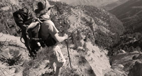
1,257 Miles of Trails on 1,762,400 Acres, with 875,000 Acres of Protected Wilderness to Explore.
Thank you for taking the time to visit the Hike Los Padres Community. This website was created with the mission of being a source of shared information on trails, camps, and locations across the entire Northern and Southern portions of the Los Padres National Forest. The more information we all share and catalog, the better we can track the conditions of the forest network and figure out what sections, trails, and locations are safe to use and which need maintenance.
A good portion of the interior of Los Padres National Forest gets very little use by the public, so any information on these areas will ensure that these places remain accessible for future generations of hikers, backpackers, trail runners, equestrians, O.H.V, hunters, cyclists, and explorers. Many of the trails listed may be unmaintained. Know your level of ability, and always remember to bring extra water.
In partnership with the Los Padres Forest Association (LPFA). The LPFA’s mission is to care for the Los Padres Forest, ensuring it thrives and remains safe and open for the people to use and enjoy. LPFA volunteers work to keep trails open, report and assess forest conditions and provide public education on how to use the forest safely. If you are interested in becoming a member or volunteering, please visit www.lpforest.org to learn more.
Location specific weather reports, recent camp and trail surveys, water data and much more.
 Kirk Creek Trail / Vicente… Hurricane Deck Trail Munch Canyon Connector… Marble Peak Trail San Ysidro Trail
  Tinta OHV Trail Ballinger Route 39 OHV… Bear Canyon Loop OHV… Ballinger Route 53 OHV… Ballinger Route 54 OHV…
 Church - Forest Rd 19S04 Cachuma Mtn - Forest… Jolla - Forest Rd 32S09 Buckhorn - Forest Rd… East Camino - Forest…
 | Location | Date ▾ | Surveyor | Water Report |
|---|---|---|---|
| Mono Campground | 1-1-1936 | Los Padres Forest Association | Flowing |
| Manzana Schoolhouse Camp | 04-21-2024 | Turbo | Flowing |
| Manzana Schoolhouse Camp | 04-20-2024 | James Downey | Flowing |
| Twin Forks Camp | 04-20-2024 | Anonymous Surveyor | Flowing |
| Three Peaks Camp | 04-19-2024 | Anonymous Surveyor | Flowing |
| Alder Creek Camp - Silver Peak Wilderness | 04-16-2024 | Rob | Flowing |
| Fish Creek Camp | 04-13-2024 | Los Padres Forest Association | Flowing |
| Madulce Camp | 04-11-2024 | Red | Flowing |
| Rays Camp | 04-10-2024 | Daniel O'Shea | Flowing |
| Big Cone Spruce Camp | 04-10-2024 | Daniel O'Shea | Flowing |
| McKinley Spings Camp | 04-10-2024 | Daniel O'Shea | Flowing |
| Fish Creek Camp | 04-09-2024 | Daniel O'Shea | Flowing |
| Manzana Camp | 04-09-2024 | Daniel O'Shea | Flowing |
| Manzana Narrows Camp | 04-09-2024 | Daniel O'Shea | Flowing |
| West Fork Lion Camp | 04-01-2024 | Neal L | Flowing |
| East Fork Lion Camp | 03-31-2024 | Daniel J. Hall | Flowing |
| Espinosa Camp | 03-23-2024 | Patrick Morgan | Flowing |
| Vincente Flat Camp | 03-23-2024 | Patrick Morgan | Flowing |
| Lion Den Camp | 03-18-2024 | Anonymous Surveyor | Flowing |
| South Fork Camp - Sisquoc | 03-14-2024 | Michael McGurk | Flowing |
| Upper Bear Camp | 03-13-2024 | Michael McGurk | Flowing |
| Mansfield Camp | 03-11-2024 | Michael McGurk | Flowing |
| Cottonwood Camp - Sisquoc Trail | 03-11-2024 | Michael McGurk | Flowing |
| Oak Camp | 03-10-2024 | Anonymous Surveyor | Flowing |
| Bear Creek Camp | 03-10-2024 | sbhikergirl | Flowing |
| Chorro Grande Camp | 03-09-2024 | Anonymous Surveyor | Flowing |
| Chorro Grande Camp | 03-09-2024 | Anonymous Surveyor | Flowing |
| Blue Canyon Camp | 03-09-2024 | Casey Hall | Flowing |
| Mission Pine Basin Camp | 03-09-2024 | Jonathan Rocque | Flowing |
| Madulce Camp | 03-09-2024 | Jonathan Rocque | Flowing |
| White Ledge Camp - Red Reef Trail | 03-08-2024 | SunMan | Flowing |
| McKinley Spings Camp | 03-08-2024 | Jonathan Rocque | Flowing |
| Mission Pine Springs Camp | 03-08-2024 | Jonathan Rocque | Flowing |
| Heath Camp | 03-07-2024 | Michael McGurk | Flowing |
| Big Pine Camp | 03-04-2024 | Michael McGurk | Flowing |
| Mission Pine Springs Camp | 03-02-2024 | Michael McGurk | Flowing |
| McKinley Spings Camp | 03-02-2024 | Michael McGurk | Flowing |
| White Ledge Camp - Red Reef Trail | 02-24-2024 | Anonymous Surveyor | Flowing |
| Chorro Grande Camp | 02-24-2024 | mwieneke | Flowing |
| Cross Camp | 02-22-2024 | Sophie E | Flowing |
| Manzana Schoolhouse Camp | 02-16-2024 | Los Padres Forest Association | Flowing |
| Mormon Camp | 02-16-2024 | Los Padres Forest Association | Flowing |
| Valley View Camp | 02-08-2024 | bardley | Flowing |
| East Fork Lion Camp | 02-03-2024 | Thacher | Flowing |
| East Fork Lion Camp | 02-02-2024 | Anonymous Surveyor | Flowing |
| Forbush Camp | 02-02-2024 | Jess Cooper | Flowing |
| Potrero John Camp | 01-26-2024 | bardley | Flowing |
| Balm of Gilead Camp | 01-26-2024 | Ryan | Dry |
| Buckeye Camp | 01-26-2024 | Ryan | Flowing |
| Lion Den Camp | 01-06-2024 | Anonymous Surveyor | Flowing |
| Valley View Camp | 01-04-2024 | Anonymous Survveyor | Flowing |
| Upper Lopez Camp | 12-31-2023 | Joel B | Flowing |
| Valley View Camp | 12-29-2023 | bardley | Flowing |
| Cow Spring Camp | 12-17-2023 | Dave Billybob | Trickle |
| Alder Creek Camp - Ventura | 12-17-2023 | Dave Billybob | Flowing |
| Upper Lopez Camp | 12-16-2023 | Peter | Flowing |
| Alder Creek Camp - Ventura | 12-15-2023 | Angel Santoyo | Flowing |
| Rock Campground | 12-12-2023 | pmeyer | Flowing |
| Potrero Camp | 12-10-2023 | Adam Donald | Flowing |
| Campo Alto Campground | 12-09-2023 | Los Padres Forest Association | Dry |
Please click on a report below to view the survey
 Mono Campground Survey - 1-1-1936 - by Los Padres Forest Association
| Link: | Mono Campground |
| Date: | 1-1-1936 |
| Surveyor Name: | Los Padres Forest Association |
| Camp Description: | Historic video showing the construction of the Mono Debris Dam from 1936, enjoy! https://archive.org/details/CCCAtMono1936 |
| Water Source: | Flowing |
| Water Source Details: | |
| Weather Conditions: |
Manzana Schoolhouse Camp Survey - 04-21-2024 - by Turbo| Link: | Manzana Schoolhouse Camp |
| Date: | 04-21-2024 |
| Surveyor Name: | Turbo |
| Camp Description: | Camp is grassy and lumpy. Most fire rings have grass in them. Toilet needs some work-missing boards. |
| Water Source: | Flowing |
| Water Source Details: | 1-3’ |
| Weather Conditions: |
Manzana Schoolhouse Camp Survey - 04-20-2024 - by James Downey| Link: | Manzana Schoolhouse Camp |
| Date: | 04-20-2024 |
| Surveyor Name: | James Downey |
| Camp Description: | Really gorgeous walk from Lower Manzana TH to the school house. Flowers in full bloom and lush grass everywhere. Hurricane deck equally as beautiful. Hot and exposed with tons of elevation gain, but lovely hike nonethe less. Took about 5 hours to hike out from Manzana School House. |
| Water Source: | Flowing |
| Water Source Details: | Fast flow of river, deepest river crossing was just above knee deep (I'm 5'10") |
| Weather Conditions: | 75 and sunny |
Twin Forks Camp Survey - 04-20-2024 - by Anonymous Surveyor| Link: | Twin Forks Camp |
| Date: | 04-20-2024 |
| Surveyor Name: | Anonymous Surveyor |
| Camp Description: | Roughly 7 river crossings to camp where 4 were knee, thigh and waist deep. Annoying gnats on the trail. Poison oak and ticks around the campsite. Firepit had left over wood, but you need saw to break them down to smaller pieces. |
| Water Source: | Flowing |
| Water Source Details: | An abundance flow. |
| Weather Conditions: | Mid 70s and low 50s |
Three Peaks Camp Survey - 04-19-2024 - by Anonymous Surveyor| Link: | Three Peaks Camp |
| Date: | 04-19-2024 |
| Surveyor Name: | Anonymous Surveyor |
| Camp Description: | Accessible from the Coast Ridge Road by an OHV, Three Peaks Camp is right next to a small, flowing creek. Main camp can handle 3-4 tents and there is a smaller site 75m upstream that can handle 1-2 tents. Both have fire rings. Only the lower camp has the same dilapidated bench pictured from 2022. |
| Water Source: | Flowing |
| Water Source Details: | flowing well after spring rains |
| Weather Conditions: | clear and 65 degrees |
Alder Creek Camp - Silver Peak Wilderness Survey - 04-16-2024 - by Rob| Link: | Alder Creek Camp - Silver Peak Wilderness |
| Date: | 04-16-2024 |
| Surveyor Name: | Rob |
| Camp Description: | Accessible by a rutted forest road, Alder Creek camp is a large camp at the junction of two creeks in a large draw. It has shade and 4 large spots, each big enough for 3-4 tents and each with a picnic table. Main site had a tree fall in the middle of it; picnic table missing one side bench (pic). |
| Water Source: | Flowing |
| Water Source Details: | both creeks flowing well after spring rains |
| Weather Conditions: | Clear, 70 degrees |
Fish Creek Camp Survey - 04-13-2024 - by Los Padres Forest Association| Link: | Fish Creek Camp |
| Date: | 04-13-2024 |
| Surveyor Name: | Los Padres Forest Association |
| Camp Description: | Recent McCaslin article about the Manzana and Fish Camp. Enjoy.... https://www.noozhawk.com/dan-mccaslin-fish-creek-canyon-lures-hikers-for-spring-backpacking |
| Water Source: | Flowing |
| Water Source Details: | Mucho WATER! |
| Weather Conditions: |
Madulce Camp Survey - 04-11-2024 - by Red| Link: | Madulce Camp |
| Date: | 04-11-2024 |
| Surveyor Name: | Red |
| Camp Description: | |
| Water Source: | Flowing |
| Water Source Details: | |
| Weather Conditions: |
Rays Camp Survey - 04-10-2024 - by Daniel O'Shea| Link: | Rays Camp |
| Date: | 04-10-2024 |
| Surveyor Name: | Daniel O'Shea |
| Camp Description: | Is a nice spot to stay if you are looking to go a little further than Fish Camp! I could only find one established spot and it is right next to river which is very nice. |
| Water Source: | Flowing |
| Water Source Details: | NIce spot! |
| Weather Conditions: | 70 sunny |
Big Cone Spruce Camp Survey - 04-10-2024 - by Daniel O'Shea| Link: | Big Cone Spruce Camp |
| Date: | 04-10-2024 |
| Surveyor Name: | Daniel O'Shea |
| Camp Description: | The trek from Manzana Narrows here was a little grueling. Lots of poison oak, downed trees, erosion, bushwhacking. So this place was a great lunch spot on my way up to McKinley Peak! |
| Water Source: | Flowing |
| Water Source Details: | Good strong flow but a little tricky to get to |
| Weather Conditions: | 70 and sunny |
Please click on a report below to view the survey
Rose Lion Trail Survey - 08-01-2024 - by Neal L| Link: | Rose Lion Trail |
| Date: | 08-01-2024 |
| Surveyor Name: | Neal L |
| Trail description: | This trail is in good shape and is easy to follow. There was some minor brush in a few sections, but otherwise just fine. |
| Mode of transport: | Hike |
| Trail condition: | Good shape and easy to follow |
Lost Valley Trail San Rafael Wilderness Survey - 04-22-2024 - by Ian Evans| Link: | Lost Valley Trail San Rafael Wilderness |
| Date: | 04-22-2024 |
| Surveyor Name: | Ian Evans |
| Trail description: | I spent probably a quarter of the trail pushing through overgrown sections of the trail, coming from the east section of Hurricane Deck down the canyon. Chest to overheard high branches from both sides made it hard to navigate through, and it was particularly bad in rocky sections where you could stumble on unseen large rocks on the ground. There are some extremely sketchy, steep bypasses around eroded trail sections in the lower canyon. Loose rocks, loose dirt, bad news if you misstep. I was wearing long sleeves and pants with shoe gaiters, which made it bearable, if not fun. Vulture Spring was flowing at both the upper crossing (mind the poison oak) and lower down where the trail cuts back. Lost Valley Creek had decent flow at Twin Oaks, and all along the lower sections. |
| Mode of transport: | Hike |
| Trail condition: | Needs some work |
| Condition details: | Significant bushwhacking required in many sections |
Lost Valley Trail Ventana Wilderness Survey - 04-21-2024 - by Anonymous Surveyor| Link: | Lost Valley Trail Ventana Wilderness |
| Date: | 04-21-2024 |
| Surveyor Name: | Anonymous Surveyor |
| Trail description: | I tried to hike on this trail from Escondido Camp to Fish Camp (so that I could pass by pothole slide waterfall, near Fish Camp). After hiking 1 mile from Escondido Camp and reaching the arroyo seco river, the trail became very difficult to follow. It was overgrown with bushes, poison oak, and obstructed by downed trees. At no point was there simply soil underfoot, we were hiking over grass and shrubs. At times I was not even sure I was following the original trail. After a half mile of that we turned back around. I think it would be fun to come back with some strong hikers and machetes and clear the way, but that was an effort I was not prepared for this time around. |
| Mode of transport: | Hike |
| Trail condition: | Non existent |
Manzana Trail West (Lower) Survey - 04-21-2024 - by Turbo| Link: | Manzana Trail West (Lower) |
| Date: | 04-21-2024 |
| Surveyor Name: | Turbo |
| Trail description: | Trail is in great shape. Flagging is pretty easy to follow. Trail is pretty well defined. No tick or snake sightings |
| Mode of transport: | Hike |
| Trail condition: | Good shape and easy to follow |
Manzana Trail West (Lower) Survey - 04-21-2024 - by Anonymous Surveyor| Link: | Manzana Trail West (Lower) |
| Date: | 04-21-2024 |
| Surveyor Name: | Anonymous Surveyor |
| Trail description: | Most crossings were thigh deep or less. Trekking poles were helpful for the deeper crossings |
| Mode of transport: | Hike |
| Trail condition: | Good shape and easy to follow |
Manzana Trail East (Upper) Survey - 04-21-2024 - by Erin Carroll| Link: | Manzana Trail East (Upper) |
| Date: | 04-21-2024 |
| Surveyor Name: | Erin Carroll |
| Trail description: | South Fork to White Ledge can be a bit rough in some areas with a few downed trees, brushy sections, etc, but totally passable. White Ledge to Nira it is clear how much work LPFA has put into the trail. Bravo! My favorite section is White Ledge to Manzana Narrows. That is a special piece of trail. Some of the crossings are a little sketchy right now due to the strong water current. |
| Mode of transport: | Hike |
| Trail condition: | Good shape and easy to follow |
Hurricane Deck Trail Survey - 04-21-2024 - by Ian Evans| Link: | Hurricane Deck Trail |
| Date: | 04-21-2024 |
| Surveyor Name: | Ian Evans |
| Trail description: | I took the Deck trail from White Ledge to Lost Valley, and had to do some significant bushwhacking in sections, most with head high closed-in growth. I had long sleeves and pants and shoe gaiters, which were pretty much required to not get shredded. Hiking poles are strongly recommended to push through the densest patches. I used a navigation app (Gaia) to make sure I was on the right track, which was occasionally very useful. The views were great when it opened up, but this trail isn't much fun right now. |
| Mode of transport: | Hike |
| Trail condition: | Needs some work |
| Condition details: | East section quite overgrown |
Manzana Trail East (Upper) Survey - 04-21-2024 - by Ian Evans| Link: | Manzana Trail East (Upper) |
| Date: | 04-21-2024 |
| Surveyor Name: | Ian Evans |
| Trail description: | Erin Carroll's report is spot on, so not much to add. From Nira to Manzana Narrows your feet will get wet, and some crossings meant knee-high (or higher) rushing water. It's nice to see this much flow after the drought years. |
| Mode of transport: | Hike |
| Trail condition: | Good shape and easy to follow |
Manzana Trail East (Upper) Survey - 04-20-2024 - by Daniel J. Hall| Link: | Manzana Trail East (Upper) |
| Date: | 04-20-2024 |
| Surveyor Name: | Daniel J. Hall |
| Trail description: | Went only from NIRA to Rays Camp. Trail in good shape and easy to follow. There were, however, a few minor brush and tread problems developing, primarily in the last mile before Rays Camp. Backpacked it April 16 - 18, only 3 to 5 days after the latest storm, and Manzana Creek was still running high and fast in places. However, the water was clear and there was lots of bright green grass on the mountainsides. Lost Valley, Fish and Rays Camps were all in good shape. For more detail see the captioned photos at https://tinyurl.com/23qymttq |
| Mode of transport: | Hike |
| Trail condition: | Good shape and easy to follow |
Sisquoc Trail Upper Survey - 04-20-2024 - by Erin Carroll| Link: | Sisquoc Trail Upper |
| Date: | 04-20-2024 |
| Surveyor Name: | Erin Carroll |
| Trail description: | I have a lot of respect for Michael McGurk completing this entire trail earlier this year. We wanted to make it up to Alamar from South Fork, but we only made it about 1 mile upstream of South Fork before we gave up. We did see some brush trimmings after climbing up out of south fork, so someone has been trying to do a little work in that section. Then we crossed the river where we saw a pink flag, but no trail anywhere near the flag. We spent about 30 minutes in that location and then we hiked up a secondary stream bed and found the trail again. We crossed the river one more time and found the trail. Then the crossing after that also had a flag but it was just nothing but overgrown poison oak and I didn't see any sign of the trail. My legs are all red from the poison oak as I write this (and I was wearing long pants and long sleeve shirt). Even my dog got poison oak! I might have gone further up this trail if I was by myself but I had my dog with me and my friend who was hiking with me didn't want to go further and I couldn't fault him for that decision. We turned around and hiked back to Nira instead of doing the bigger loop we had planned to do. Sometimes you have to know when to cut your losses and turn around. |
| Mode of transport: | Hike |
| Trail condition: | Non existent |
| Condition details: | Needs a massive amount of work. Tons of poison oak. |
 Pelch Camp
 McKinley Mountain
  Cold Spring - Ventana