Welcome To Hike Los Padres!
User Log In or Sign Up
Use Marker Cluster
Markers: Use Marker Groups
Time used: ms
Routes
    Trails
    OHV Trails
    Forest Roads
    Streams
Wildfire Layers
    Wolf 2002
    Piru 2003
    Day 2006
    Zaca 2007
    Gap 2008
    La Brea 2009
Forest Layers
    Forest Boundary
    Wilderness Areas
    Ranger Districts
    Counties
    Topographic Outlines
    Trailheads
    OHV Trailheads
Helpful Hints
    ↣ Right click the map for location data. ↣ Click a stream for Water Stats.

Lost Valley Trail Ventana Wilderness - Los Padres National Forest
Trail Distance 11.08 Miles

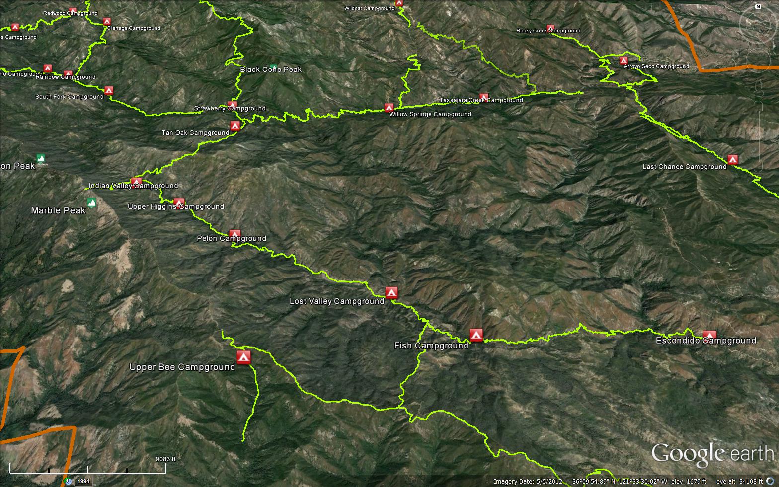
The Lost Valley Trail Ventana Wilderness is a 11.08 mile trail in the Ventana Wilderness in Monterey County .
The trail connects the Marble Peak Trail (4E07) and Escondido Campground (2200 feet). Please let us know if you have explored this trail recently.

Trail Details

  • Trail #: 4E08
  • Wilderness Area: Ventana
  • County: Monterey County
  • Ranger District: Monterey Ranger District
  • Trail-head Latitude: 36.14147856
  • Trail-head Longitude: -121.4950033
  • Trail Condition: Kind of Good - Little to no bushwacking and easily followable
  • Topo Maps:
  • Activities & Features:
    • Backpacking
    • Creek
    • Day Hiking
    • Wildlife Viewing
    • Wilderness Camping


Trail Stats

  • Total Elevation Gain: + 4367 feet.
  • Total Elevation Loss: - 3652 feet.
  • Overall Average Slope Gain: + 11 %.
  • Overall Average Slope Loss: - 11 %.
  • Kilometers: (km)
  • Meters: (m)
  • Miles: (mi)
  • Feet: (ft)
  • Average Slope: (%)

Trail Camps

Upload Images Aerial Overview Image Login to Download GPS File
Survey This Trail

Submitted Trail Reports

Lost Valley Trail Ventana Wilderness Survey - 04-21-2024 - by Anonymous Surveyor
Link: Lost Valley Trail Ventana Wilderness
Date: 04-21-2024
Surveyor Name:Anonymous Surveyor
Trail description:I tried to hike on this trail from Escondido Camp to Fish Camp (so that I could pass by pothole slide waterfall, near Fish Camp). After hiking 1 mile from Escondido Camp and reaching the arroyo seco river, the trail became very difficult to follow. It was overgrown with bushes, poison oak, and obstructed by downed trees. At no point was there simply soil underfoot, we were hiking over grass and shrubs. At times I was not even sure I was following the original trail. After a half mile of that we turned back around. I think it would be fun to come back with some strong hikers and machetes and clear the way, but that was an effort I was not prepared for this time around. 
Mode of transport:Hike
Trail condition:Non existent


Leave A Trail Report

Survey / Report Form - Please click this box to open the form.


Last Updated: Wednesday, February 24, 2016


Join Mailing List
×
Get updates on conditions, surveys and more...


Current Weather »


L.P.N.F. Contacts »

  • Forest Headquarters
    Phone: (805) 968-6640
  • Mt. Pinos District
    Phone: (661) 245-3731
  • Ojai Ranger District
    Phone: (805) 646-4348
  • Santa Barbara District
    Phone: (805) 967-3481
  • Santa Lucia District
    Phone: (805) 925-9538
  • Monterey District
    Phone: (831) 385-5434