 Use Marker Groups
 Wolf 2002
Piru 2003
Day 2006
Zaca 2007
Gap 2008
La Brea 2009

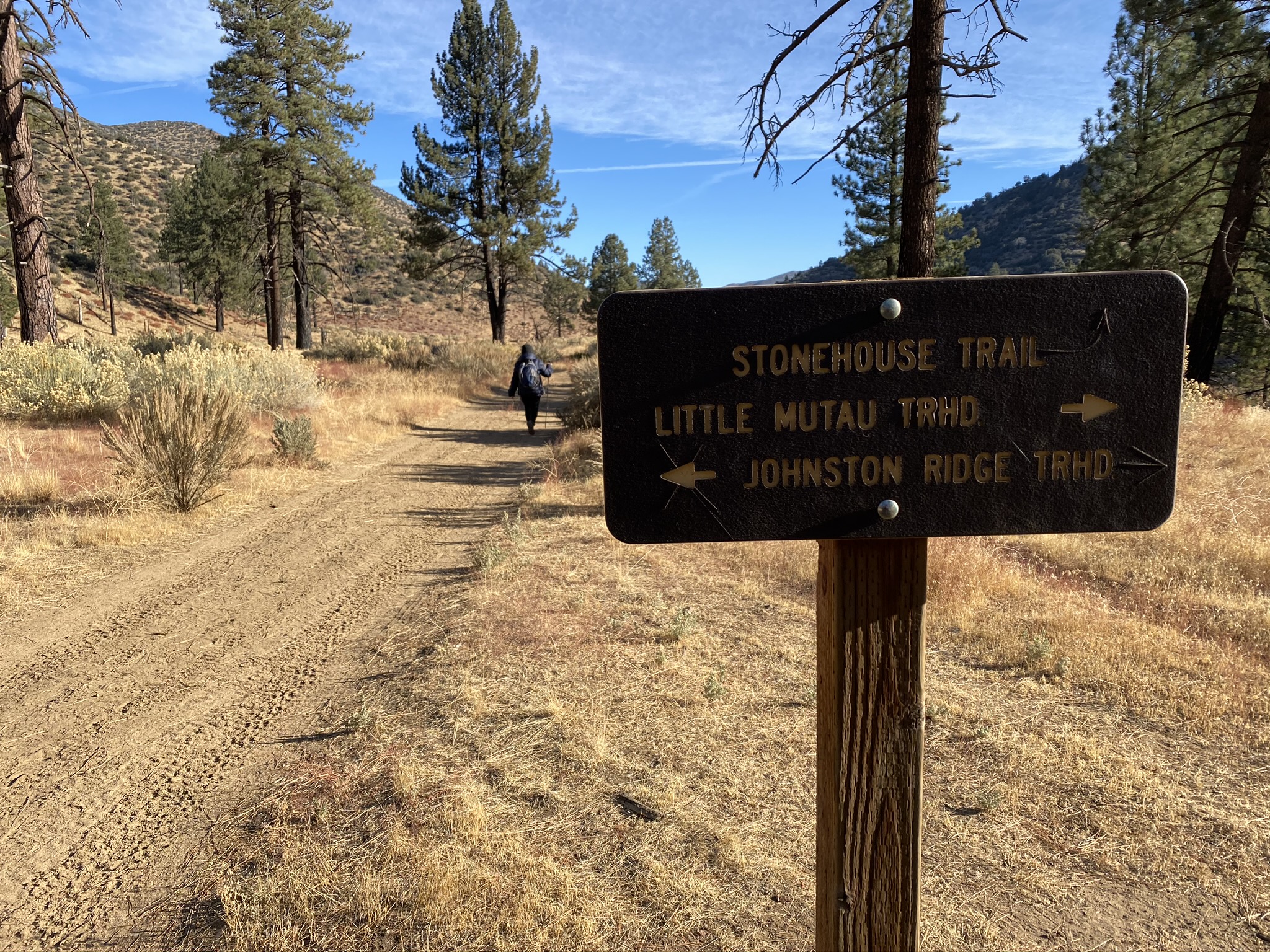
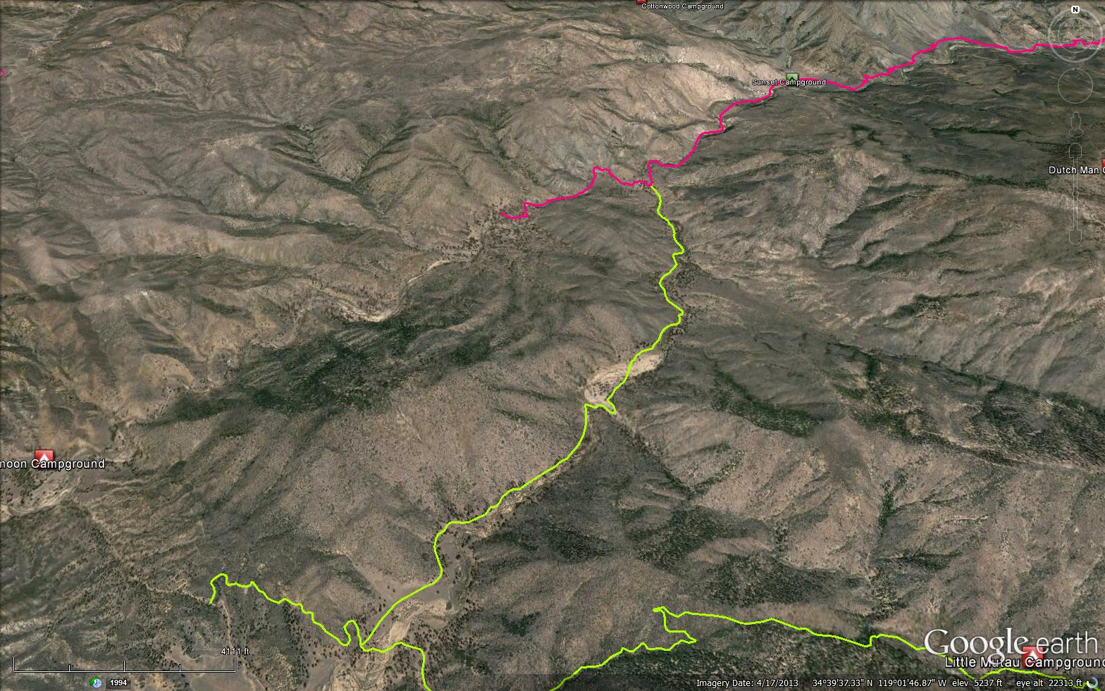
The Stonehouse Trail is a creek side 3.97 mile trail in the Sespe Wilderness in Ventura County . The trail connects the Johnston Ridge Trail (20W12) to the Piru OHV Trail (20W07). Please let us know if you have explored this trail recently.


 Stonehouse Trail Survey - 04-29-2025 - by Tom Fritz
| Link: | Stonehouse Trail |
| Date: | 04-29-2025 |
| Surveyor Name: | Tom Fritz |
| Trail description: | Hiked the Stonehouse trail from where the Mutau Creek meets up with the Piru, southwest to where the intersection with Johnston Ridge Trail. Trail was in good shape. No large blowdowns. It seemed as though the area is seeing less quad/moto activity as in years past – when it was starting to feel like I was walking through an OHV area! Having said that, I followed a single motorcycle track the entire way. Water flowing well out of Alamo Creek into the Mutau. And the Mutau was flowing the entire way out of Mutau Flats – it hasn't gone underground yet near the big sandy crossing. All stream crossings were straight-forward. |
| Mode of transport: | Hike |
| Trail condition: | Good shape and easy to follow |
Stonehouse Trail Survey - 09-18-2024 - by Los Padres Forest Association| Link: | Stonehouse Trail |
| Date: | 09-18-2024 |
| Surveyor Name: | Los Padres Forest Association |
| Trail description: | Hiked up Stonehouse as part of a loop from Halfmoon Campground. The trail was in good shape for the most part with some brush at the crossings and a few places where I briefly lost the trail. The junction of Little Mutau and Mutau was a little confusing and below that there was a section on the west side of the creek that had a bunch of downed trees and the motos were going around them rather than where the trail should be. All in all, NOT BAD AT ALL and a lovely hike. Didn't see a single person the entire day! Have at it..... Technically this is a non-motorized trail but there were signs of trucks using the trail near Mutau and motos along the extent of the trail. |
| Mode of transport: | Hike |
| Trail condition: | Needs some work |
| Condition details: | Water was flowing along most of the trail but there were some dry areas. |
Stonehouse Trail Survey - 05-15-2024 - by Anonymous Surveyor| Link: | Stonehouse Trail |
| Date: | 05-15-2024 |
| Surveyor Name: | Anonymous Surveyor |
| Trail description: | Hiked the loop from halfmoon. The trail is very faint in grassy areas and non-existent in sandy creek areas, but since you are going downhill along a creek it's difficult to get lost for real. Plenty of OHV tracks, some fresh this year since the last rain. I took off my shoes twice to cross the creek to stay dry, definitely worth the extra 5 minutes. |
| Mode of transport: | Hike |
| Trail condition: | Needs some work |
Stonehouse Trail Survey - 04-21-2021 - by Tom Fritz| Link: | Stonehouse Trail |
| Date: | 04-21-2021 |
| Surveyor Name: | Tom Fritz |
| Trail description: | I hiked this trail as a portion of my Sespe Loop trip, entering from the Mutau Flat area and proceeding NW to the Piru creek. I've noticed since 2018 that there is an incredible amount of ATV tracks in the Mutau Creek creek-bed itself, well beyond the designated Mutau Flat private inholdings. They tracks in the creek bed are destroying the plant life and the riparian soil, climbing (eroding) the bank at various points, and looping up into the trailside areas as they try to circumnavigate the fallen trees – obliterating the trail and churning up the natural ground cover still trying to recover from the 2006 Day Fire. It's starting to feel like a hike through an OHV designated area, which it is not. The tracks are four-wheel ATVs and not dirt bikes. |
| Mode of transport: | Hike |
| Trail condition: | Needs some work |
| Condition details: | What is with all the ATV tracks? |
Stonehouse Trail Survey - 04-13-2021 - by Diane Soini| Link: | Stonehouse Trail |
| Date: | 04-13-2021 |
| Surveyor Name: | Diane Soini |
| Trail description: | I hiked this trail from Johnston Ridge to Piru Creek. It is not that interesting of a trail, but it is a good connector trail. It would be easy to walk by the stone house without seeing it, but I happened to catch it in my peripheral vision so I went to check it out. I wasn't sure how to get to it as there did not appear to be a trail to it, so I bushwhacked across the creek through a lot of painful wild rose vines that tore me up. A large tree fell on the stone house camp and pretty much destroyed it. I found a nicer place to camp at the junction of Little Mutau creek and Piru Creek. |
| Mode of transport: | Hike |
| Trail condition: | Good shape and easy to follow |
| Images: | The trail mostly looks like this the whole way. The stone house is off the trail and easy to miss. The stone house camp is mostly destroyed. There is a large fallen tree and nowhere flat to put a tent and the water is hard to get to. There's a nicer place to camp where Little Mutau and Piru Creek converge. There is a lot of trash in this camp, though, much of it wedged under the large boulder behind the tree. |
Stonehouse Trail Survey - 11-15-2020 - by Antonio Calderon| Link: | Stonehouse Trail |
| Date: | 11-15-2020 |
| Surveyor Name: | Antonio Calderon |
| Trail description: | From Johnston ridge trail head to the old stonehouse camp the trail is in fairly good shape. Weather was nice, a chilly 34 degrees in the morning and warmed Up to mid 60s in the afternoon. Water was available at the Mutau/Alamo confluence. A nice flat a few yards away from old camp would make a better choice for camping. |
| Mode of transport: | Hike |
| Trail condition: | Good shape and easy to follow |
| Images: | Stone house camp Nice shaded flat with fire ring Water near camp |
Stonehouse Trail Survey - 10-12-2019 - by Craig R. Carey| Link: | Stonehouse Trail |
| Date: | 10-12-2019 |
| Surveyor Name: | Craig R. Carey |
| Trail description: | Hiked the length of Stonehouse Trail from Johnston/Little Mutau junction to Halfmoon/Piru OHV trail junction on Sat 10/12/19. Great temps, breezy. Bugs weren't as bad as they've been lately. Lots of OHV trespass apparent on the trail, and big debris washout at the Mutau/Little Mutau confluence, but otherwise tread is in good shape. Water at all crossings (both Mutau and Alamo have good water at the moment). Old Stonehouse trail camp still standing, though a large tree has come down in the middle of the field. |
| Mode of transport: | Hike |
| Trail condition: | Needs some work |
| Images: | Survivor. Two Legends of the Los Padres Meet Again. |
Stonehouse Trail Survey - 05-29-2016 - by Anonymous Surveyor| Link: | Stonehouse Trail |
| Date: | 05-29-2016 |
| Surveyor Name: | Anonymous Surveyor |
| Trail description: | The trail is reachable by first hiking about a mile on the Johnston Ridge Trail and taking lefts at the two junctions (second one marked by a sign). Johnston Ridge Trailhead was inaccessible to any cars without high clearance (Pickups, SUVs) due to the high water levels at the two creek crossings on the Grade Valley Road (Forest Rte 7N03). Did not see the old Stone House Camp (not maintained) while hiking the trail, but there were viable options for camping near flowing water towards the end of the trail. Trail ends on an intersection with a Motorcycle Trail that goes along Piru Creek. Saw not a single other hiker on Memorial Day Weekend. Very secluded. |
| Mode of transport: | Hike |
| Trail condition: | Good shape and easy to follow |
Stonehouse Trail Survey - 01-28-2014 - by Anonymous Surveyor| Link: | Stonehouse Trail |
| Date: | 01-28-2014 |
| Surveyor Name: | Anonymous Surveyor |
| Trail description: |
 Survey / Report Form - Please click this box to open the form.