 Use Marker Groups
 Wolf 2002
Piru 2003
Day 2006
Zaca 2007
Gap 2008
La Brea 2009

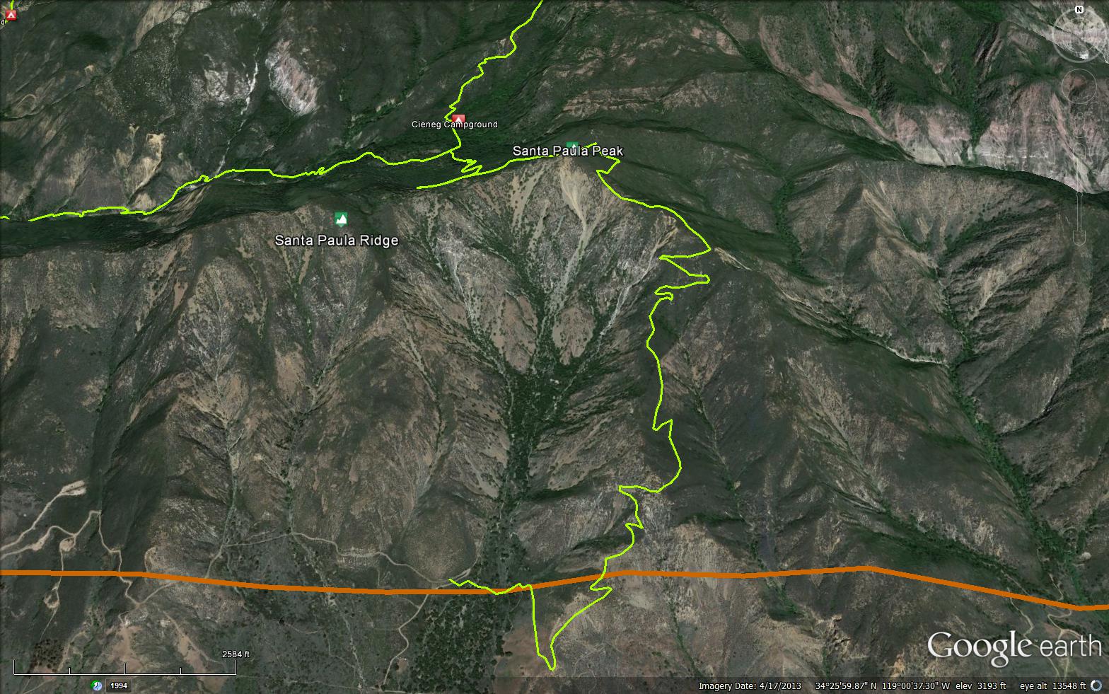
Located in the Oaji Ranger District above Thomas Aquinas College. The Santa Paula Canyon Trail is a 6.05 mile trail in the Non Wilderness Area Wilderness in Ventura County . The trail starts at Thomas Aquinas College and climbs to connect the Last Chance Trail (21W09) and then continues to the Santa Paula Peak Trail (20W16). Please let us know if you have explored this trail recently.


 Santa Paula Canyon Trail Survey - 03-29-2025 - by Rick Hayes
| Link: | Santa Paula Canyon Trail |
| Date: | 03-29-2025 |
| Surveyor Name: | Rick Hayes |
| Trail description: | Hiked to Bluff Camp. Need pants, long sleeves, trekking poles and Garmin or Gaia app to follow the trail after leaving the creek all the way to Bluff camp. Flagging to Cienega camp. Some of the flagging was wrong. Bear trails everywhere, lots of false trails. Tons of water at Cienega camp. Some flowing water at Bluff camp. Even more flowing water on the backside of the ridge of Bluff camp. Rock cairns from Cienega to Bluff |
| Mode of transport: | Hike |
| Trail condition: | Hard to follow |
Santa Paula Canyon Trail Survey - 11-27-2024 - by Anonymous Surveyor| Link: | Santa Paula Canyon Trail |
| Date: | 11-27-2024 |
| Surveyor Name: | Anonymous Surveyor |
| Trail description: | The hike through the lower canyon is fine if you follow the spray painted black diamonds, but it is occasionally confusing. There's not much actual trail for the 1st 2.5 miles before you climb out of the canyon towards big cone camp, mostly rocks and river crossings (9 each way). Great shape from there all the way to cross camp. The trail above cross camp is quickly disappearing and getting damaged. The brush is impassible in some places, leading people to go off trail and cause significant trail damage. I've seen the occasional person up there trimming brush, but it's going to be completely impassible soon. |
| Mode of transport: | Hike |
| Trail condition: | Needs some work |
| Condition details: | Good to cross camp, disappearing above cross camp |
Santa Paula Canyon Trail Survey - 07-05-2024 - by Anonymous Surveyor| Link: | Santa Paula Canyon Trail |
| Date: | 07-05-2024 |
| Surveyor Name: | Anonymous Surveyor |
| Trail description: | This trail is advertised online as a good waterside trail for dogs, but upon entering the water at the start of the trail our three dogs became covered in thick tarry oil. We had to immediately leave and go to the nearest park bathroom to try and scrub them down as much as possible. There needs to be a sign at the start of the trail warning people with dogs about this oil in the water. |
| Mode of transport: | Hike |
| Trail condition: | Needs some work |
| Condition details: | Oil in water- danger to dogs |
Santa Paula Canyon Trail Survey - 08-21-2022 - by Andy M| Link: | Santa Paula Canyon Trail |
| Date: | 08-21-2022 |
| Surveyor Name: | Andy M |
| Trail description: | Trail up the East Fork to Cieneg is in rough shape after about a mile from the junction. I felt glad for even 100 yards of trail at a time. Someone has blazed in a rainbow of colors, but not consistent. I had planned to visit Cieneg then summit Santa Paula Peak, but had to turn back. There is an unmarked campsite with simple fire grate about halfway. Santa Paula Peak trail appears to be washed out, at least I couldn't find it. Don't try this trail unless you are very confident in your backcountry skills. Thank you to Friends of Los Padres for the maintenance work you do! A few saws, machetes, and blaze paint would do wonders. I saw loads of large animal scat and tracks. |
| Mode of transport: | Hike |
| Trail condition: | Non existent |
| Images: | Awesome views Example of the unconventional blazing Unmarked campsite roughly halfway between Big Cone and Cieneg Animal tracks Very cool waterfall |
Santa Paula Canyon Trail Survey - 05-26-2021 - by Josie| Link: | Santa Paula Canyon Trail |
| Date: | 05-26-2021 |
| Surveyor Name: | Josie |
| Trail description: | Trail is in great shape to Big Cone camp. From Big Cone east, it becomes increasingly difficult to follow. There is some pink flagging in places and a few cairns to help mark the way, but the creek has reclaimed a lot of trail. Keep your eyes up and pay attention, especially towards the end! We had hoped to visit Cienega camp, but lost the trail in the last ~half mile and couldn't find the right spot to leave the creek. Lots of flowers in bloom despite the low rain. |
| Mode of transport: | Hike |
| Trail condition: | Hard to follow |
Santa Paula Canyon Trail Survey - 09-22-2019 - by Christopher P. Lord| Link: | Santa Paula Canyon Trail |
| Date: | 09-22-2019 |
| Surveyor Name: | Christopher P. Lord |
| Trail description: | Travelled the length of the East fork 21W11 on Sunday from Cienega Camp to the new trailhead access at Thomas Aquinas College. Reading prior reports of this trail makes the journey sound horrendous, in reality it is not that bad if you understand whats going here. The trail is in great shape from the college to Big Cone Camp. After dropping into the creek from Big cone only sporadic sections exist the rest is purley boulder hopping. Pink flagging can be followed all the way up the creek and to the exit point where you will make the climb to cienega at N34° 26' 49.5" W119° 01' 35.4" Make sure to not blow past this point or you will dead end into a waterfall and have to back track. Waterflow right now is easily manageable, I did not once get my feet wet. The poison oak is easily avoidable, wear long sleeves and pants if you're susceptible. This by no means needs to be an exercise in suffering. I found this trail to be lovely and just the kind off remote adventure I'm looking for. Anyone who has experience travelling through creek beds may feel the same. For further details see the link below. |
| Mode of transport: | Hike |
| Trail condition: | Hard to follow |
| Images: | lots of boulder hopping Plaster looking walls Exit point for Cienega notice the pink Flagging How nice is that ? Another view of where to exit for Cienega |
Santa Paula Canyon Trail Survey - 10-06-2018 - by C Goodyear| Link: | Santa Paula Canyon Trail |
| Date: | 10-06-2018 |
| Surveyor Name: | C Goodyear |
| Trail description: | Goal today was to hike the whole trail up to either SP Peak or Bluff Camp. It was smooth sailing up to Big Cone Campground and the lower Punchbowls. East past the Punchbowls was purely an exercise in suffering, though. Less than a quarter mile in, I gave up trying to find any consistent semblance of a trail. I saw occasional tape flags from someone's earlier trip, but the very best paths were just brief runs of loose, sandy creek bed; other than that it's all scrambling through overgrown, boulder-stacked, (often loose) debris-filled narrows while dodging fields of poison oak. Even machete-ing through the tougher underbrush turned out to be pretty useless. In the end, I was just under half a mile from Cieneg Camp when I ran into an impassable, ~100 ft high dry waterfall. Both GPS and the terrain told me I was on the right course, but I'd seen absolutely nothing besides the creek bed that looked remotely navigable. If there ever was a real trail out in those parts, it's long gone by now. |
| Mode of transport: | Hike |
| Trail condition: | Non existent |
| Condition details: | Naught but a Bushwhack Past The Punchbowls |
| Images: | All quiet at Big Cone East of the Punchbowls,this is the very best the trail gets (and it doesn't last long). Pretty, but not a practical path; it winds up climbing the wall to the left to get past. Typical view of an only-route-available. End of the line, but probably gorgeous in the rain. |
Santa Paula Canyon Trail Survey - 09-16-2017 - by Fritz | Link: | Santa Paula Canyon Trail |
| Date: | 09-16-2017 |
| Surveyor Name: | Fritz |
| Trail description: | The trail section from the punch bowls to Jackson Hole camp was heavily overgrown and nearly impassable. There were points where we were on our hands and knees crawling under brush. Lost the trail twice and had to backtrack and search for markers. Game trails look more heavily used then the actual trail. Took about 2.5 hours to hike the 1.5 miles to the falls. |
| Mode of transport: | Hike |
| Trail condition: | Hard to follow |
| Condition details: | Easy trail from the college to the puch bowls. Punch bowls to Jackson Hole camp was heavily overgrown and nearly impassable. |
Santa Paula Canyon Trail Survey - 07-22-2017 - by Anonymous Surveyor| Link: | Santa Paula Canyon Trail |
| Date: | 07-22-2017 |
| Surveyor Name: | Anonymous Surveyor |
| Trail description: | Due to fire and investigation |
| Mode of transport: | Hike |
| Trail condition: | Non existent |
| Condition details: | Trail closed |
| Images: | Trail closed at highway |
Santa Paula Canyon Trail Survey - 07-21-2017 - by Anonymous Surveyor| Link: | Santa Paula Canyon Trail |
| Date: | 07-21-2017 |
| Surveyor Name: | Anonymous Surveyor |
| Trail description: | Trail Curently CLOSEDÂ |
| Mode of transport: | Hike |
| Trail condition: | Non existent |
| Condition details: | Forest Service has Closed this trail, it will be closed for weeks due to a major fire |
Santa Paula Canyon Trail Survey - 06-05-2017 - by Ellie| Link: | Santa Paula Canyon Trail |
| Date: | 06-05-2017 |
| Surveyor Name: | Ellie |
| Trail description: | Trail was easy to follow, but littered with trash and graffiti. We picked up enough trash to fill an entire garbage bag. The water was flowing and cold. We also went for a swim in all three of the pools. Great hike if you can ignore the graffiti. |
| Mode of transport: | Hike |
| Trail condition: | Good shape and easy to follow |
Santa Paula Canyon Trail Survey - 04-06-2015 - by Dave Leoncavallo| Link: | Santa Paula Canyon Trail |
| Date: | 04-06-2015 |
| Surveyor Name: | Dave Leoncavallo |
| Trail description: | The trail is easy to follow, though polluted, from Thomas Aquinas to Big Cone camp. Â Turning east, it quickly becomes non-existent from Big Cone to La Cienaga. Â We had to creek hop for most of the journey. Â We had the help of GPS to guide us to the point in the creek bed where the trail materializes again up a wooded slope to the east. Â Without the GPS, I don't know if we would have found the trail again. Â Lots of poison oak along the way and not a soul to be found. |
| Mode of transport: | Hike |
| Trail condition: | Hard to follow |
| Condition details: | Thomas Aquinas to La Cienaga |
Santa Paula Canyon Trail Survey - 06-08-2014 - by Nate Kirby| Link: | Santa Paula Canyon Trail |
| Date: | 06-08-2014 |
| Surveyor Name: | Nate Kirby |
| Trail description: | This is a tale of two trails. The first half is trashed from overuse and the second has been totally neglected. Santa Paula Canyon trail up to Jackson Camp. The trail is wide and well traveled from Thomas Aquinas to Cross Camp above the Punch Bowl. The portion of the trail between Cross Camp and Jackson Camp is in very poor condition - heavily overgrown and difficult to follow. The contrast is amazing. |
| Mode of transport: | Hike |
| Trail condition: | Hard to follow |
| Condition details: | Brushy, overgrown, poison oak, washed out tread |
| People Seen: | 10-20 |
 Survey / Report Form - Please click this box to open the form.