 Use Marker Groups
 Wolf 2002
Piru 2003
Day 2006
Zaca 2007
Gap 2008
La Brea 2009

WARNING:
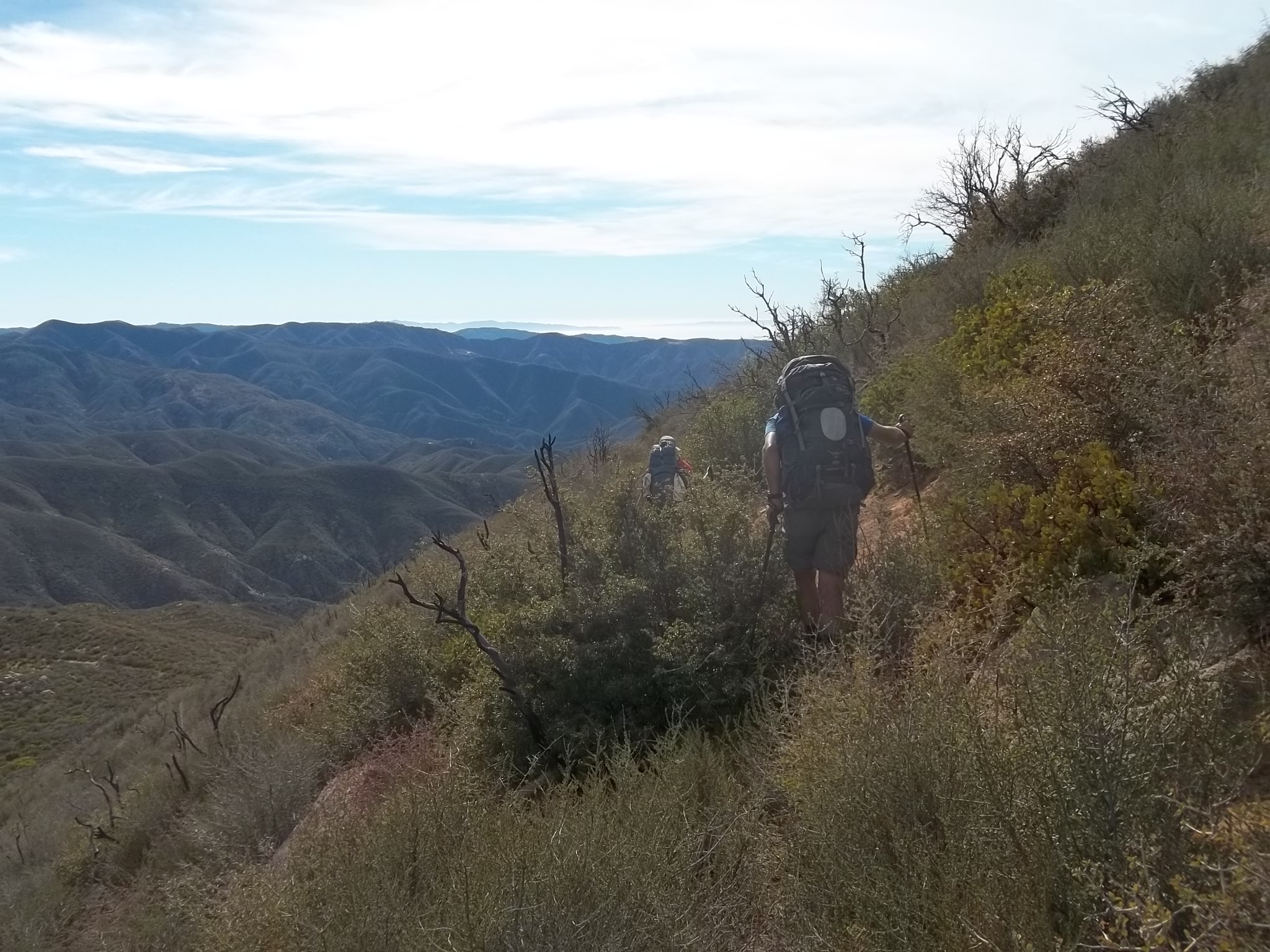
THERE IS A SKETCHY SLIDE LOCATED ABOUT 4 MILES UP THE TRAIL FROM UPPER OSO ALONG THE SOUTH SLOPE OF LITTLE PINE MOUNTAIN THAT IS NOT PASSABLE FOR SOME TRAIL USERS. THE SLIDE IS 100% NOT STOCK PASSABLE. WHILE MOST HIKERS AND MOUNTAIN BIKERS ARE ABLE TO GET PAST THE SLIDE, THERE ARE SOME WHO HAVE TO TURN AROUND DUE TO THE SKETCHINESS AND EXPOSURE AT THE SLIDE LOCATION.
OTHER THAN THAT, THE TRAIL IS FOLLOWABLE AND IN GOOD ENOUGH SHAPE BY LOS PADRES STANDARDS FROM UPPER OSO TO MISSION PINE BASIN.
CONTINUED EFFORTS ARE UNDERWAY TO RESTORE THE TRAIL BUT IT'S GOING TO TAKE A FEW YEARS FOR THE TRAIL WORK TO BE COMPLETED. FOR MORE INFORMATION OR TO HELP, CONTACT THE LPFA AT: INFO@LPFOREST.ORG
---- • ---- • ---- • ----
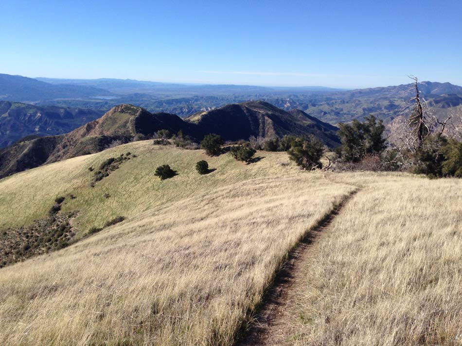
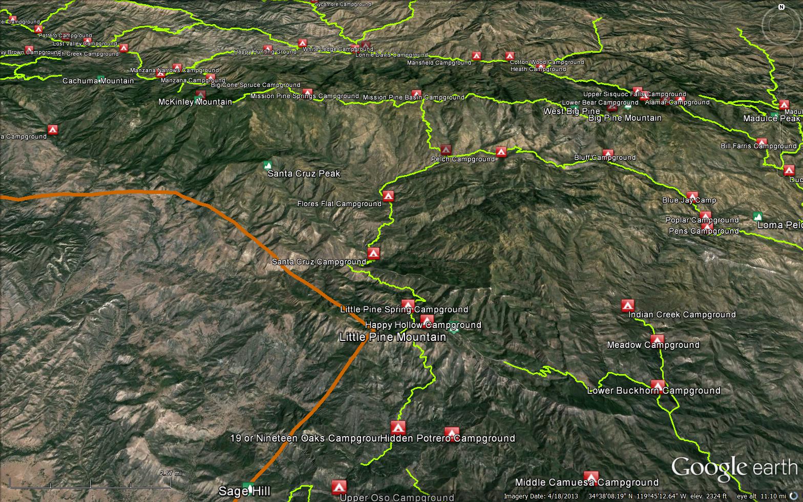
The Santa Cruz Trail starts about a mile above Upper Oso along the Buckhorn Rd and ends at Mission Pine Basin. The trail starts in Oso Canyon and winds up towards Little Pine through the oaks and along the creek. It passes 19 Oaks camp and then starts a steady climb up Little Pine Mtn. At Alexander Saddle the trail drops down into the Santa Cruz drainage amongst pines, serpentine rocks and grasslands. After passing Little Pine Spring Camp, the trail passes along a steep sidehill called the "40 Mile Wall". Even though the this section of the trail is only 2+ miles long, it feels much longer as the trail undulates in and out of side canyons. Shortly after the 40 Mile Wall the trail switches back into Santa Cruz Station and Santa Cruz Creek.
From here the trail climbes steeply through Romo Poterero, up and over into the San Rafael Wilderness. The trail crosses the West Fork Santa Cruz just below Flores Flat Camp before heading up Coche Creek. There are two camps along Coche Creek (Kellogg and Coche) before the trail climbs steeply up the San Rafael Mtns to its terminus at Mission Pine Basin.
NOTE:
The non-wilderness sections of the trail are popular with mtn bikers, horses and hikers. If you are a mtn biker PLEASE WEAR BELLS ON YOUR BIKE. It helps everyone. Thanks.

.JPG)


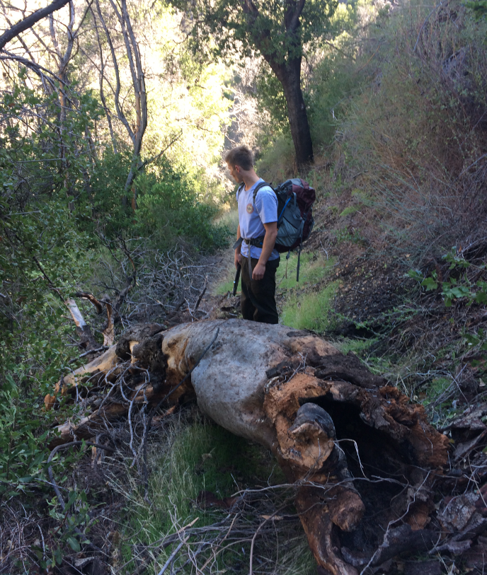
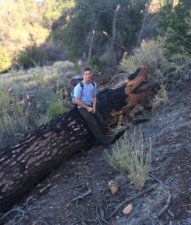
 Santa Cruz Trail Survey - 04-22-2026 - by Rick Hayes
| Link: | Santa Cruz Trail |
| Date: | 04-22-2026 |
| Surveyor Name: | Rick Hayes |
| Trail description: | Horrible crawling and bushwacking mission pine basin down to Kellogg camp with a daypack. |
| Mode of transport: | Hike |
| Trail condition: | Hard to follow |
Santa Cruz Trail Survey - 03-10-2026 - by Los Padres Forest Association| Link: | Santa Cruz Trail |
| Date: | 03-10-2026 |
| Surveyor Name: | Los Padres Forest Association |
| Trail description: | From a friend of the LPFA who hiked from Mission Pine Basin down to Santa Cruz Station: Santa Cruz from Mission Pine to Kellogg
–godawful. The chaparral is head
high especially a nasty thorny plant that reminds me of ceanothus and
left us both bloody. However if you could pack a group into Kellogg from
Santa Cruz and host a several day mission just with loppers, you could
get most of it cleared. A few small down logs Kellogg to Santa Cruz GS—much better, some down logs and brush to chop. Cabin is beautiful; did LFPA or the fire crew repaint it? Looks like you guys have done concerted effort on this trail and almost keep it open! Santa Cruz creek VERY high and I did not enjoy crossing right where two branches meet! |
| Mode of transport: | Hike |
| Trail condition: | Needs some work |
Santa Cruz Trail Survey - 05-27-2024 - by Clancy| Link: | Santa Cruz Trail |
| Date: | 05-27-2024 |
| Surveyor Name: | Clancy |
| Trail description: | We hiked the entire SC trail from Mission Pine Basin down to Upper Oso. Starting at the top, the trail is easy to follow and clear to where it drops off and starts to switchback. From here down to the creek it is fairly easy to follow for the most part with a few tricky sections. Lots and lots of pushing through waist to shoulder high brush. From Coche Creek to Santa Cruz Station the trail is pretty easy to follow with plenty of ducking, pushing through, and occasionally crawling through brush. Quite a bit of poison oak in places especially around creek crossings. From SC station to the 40 mile walk is great. The 40 mile walk is generally pretty good. One small washout. The dry grass was slippery and not that fun to walk on though. From the creek at the end of the wall to Alexander Saddle was slower going. Lots of down brush and poison oak. Similar to the upper sections of the trail but more concentrated. One bit of route finding tricky bit on the grassy hillside near Little Pine Spring. From Alexander Saddle down to Upper Oso is in really nice shape except for lots of grass and a couple slides. The slides are fairly easily passed but would not be recommended for those afraid of heights or not confident in their footing. |
| Mode of transport: | Hike |
| Trail condition: | Needs some work |
Santa Cruz Trail Survey - 05-21-2021 - by Los Padres Forest Association| Link: | Santa Cruz Trail |
| Date: | 05-21-2021 |
| Surveyor Name: | Los Padres Forest Association |
| Trail description: | Sharing a YouTube video of a couple from LA who came and hiked the Santa Cruz Trail. It's good to see and hear peoples thoughts on our camps/trails and if nothing else this helps document the current shape of the SC Trail. Enjoy.... https://www.youtube.com/watch?v=g6rfHTXaLSs |
| Mode of transport: | Hike |
| Trail condition: | Hard to follow |
Santa Cruz Trail Survey - 04-30-2021 - by Los Padres Forest Association| Link: | Santa Cruz Trail |
| Date: | 04-30-2021 |
| Surveyor Name: | Los Padres Forest Association |
| Trail description: | The LPFA completed three weeks of trail work along the Santa Cruz Trail in April 2021 focused on working from Santa Cruz Station up into the wilderness and out to Kellogg Camp near the junction of the Grapevine Trail. Work was accomplished with a combination of Trail Crew and a larger volunteer Working Vacation. The trail was in top-notch excellent condition from SC Station to Kellogg - clear of all downed trees, large swaths of poison oak and the other trail impeding brush. Enjoy! |
| Mode of transport: | Array |
| Trail condition: | Needs some work |
Santa Cruz Trail Survey - 02-12-2022 - by Jeff Harker| Link: | Santa Cruz Trail |
| Date: | 02-12-2022 |
| Surveyor Name: | Jeff Harker |
| Trail description: | Hiked from Upper Oso to the saddle at about 5 miles in. Trail was in really good shape except for two significant washouts at about the 3.8 mile point. Very sketchy to pass through. Views were fantastic. Very little poison oak seen and no ticks. |
| Mode of transport: | Hike |
| Trail condition: | Needs some work |
| Images: | |
Santa Cruz Trail Survey - 02-05-2022 - by Stephen S| Link: | Santa Cruz Trail |
| Date: | 02-05-2022 |
| Surveyor Name: | Stephen S |
| Trail description: | I hiked down Santa Cruz Trail from Mission Pine Basin to Grapevine Trail junction. A few parts were followable, but it was very overgrown and slow going for a lot of it. |
| Mode of transport: | Hike |
| Trail condition: | Hard to follow |
| Images: | there was a lot of this |
Santa Cruz Trail Survey - 01-13-2021 - by John O'Connell| Link: | Santa Cruz Trail |
| Date: | 01-13-2021 |
| Surveyor Name: | John O'Connell |
| Trail description: | Trail from 19 oaks to happy hollow was in fairly good shape for most of it, but spots had some extreme erosion that made crossing a little worrisome. These eroded spots could use some shoring up but otherwise the trail looks good! |
| Mode of transport: | Hike |
| Trail condition: | Needs some work |
Santa Cruz Trail Survey - 12-20-2020 - by Bingo Wathen| Link: | Santa Cruz Trail |
| Date: | 12-20-2020 |
| Surveyor Name: | Bingo Wathen |
| Trail description: | Hiked from Upper Oso to Alexander Saddle. Apart from a few passable slides the trail is in good shape. Did not go north of Alexander Saddle. Thank you trail crews! |
| Mode of transport: | Hike |
| Trail condition: | Good shape and easy to follow |
Santa Cruz Trail Survey - 07-28-2020 - by Anonymous Surveyor| Link: | Santa Cruz Trail |
| Date: | 07-28-2020 |
| Surveyor Name: | Anonymous Surveyor |
| Trail description: | We hiked from Santa Cruz Camp to Happy Hollow via the Santa Cruz Trail and down to Upper Oso via the Forestry Road. General trail conditions: 1. Santa Cruz Camp to 40-mile Wall had a few downed trees but was generally in good shape with only slight overgrowth near the Santa Cruz Creek. The trail needs tree-work. 2. The 40-mile wall wasn't in bad shape. We saw a rattlesnake cross the trail in front of us. 3. Upper 40-mile wall to Little Pine was heavily overgrown with lots of poison oak and a few downed trees. The meadow path was hard to follow in places, but not too difficult. 4. Little Pine to Alexander Saddle is very sketchy with lots of washouts. I would not recommend trying to pass until trail work is conducted on this section. |
| Mode of transport: | Hike |
| Trail condition: | Needs some work |
Santa Cruz Trail Survey - 07-26-2020 - by James G.| Link: | Santa Cruz Trail |
| Date: | 07-26-2020 |
| Surveyor Name: | James G. |
| Trail description: | We hiked from Santa Cruz Camp to Happy Hollow and down to Upper Oso via the Santa Cruz Trail. General trail conditions: 1. Santa Cruz Camp to 40-mile Wall had a few downed trees but was generally in good shape with only slight overgrowth near the Santa Cruz Creek. The trail needs tree-work. 2. The 40-mile wall wasn't in bad shape. We saw a rattlesnake cross the trail in front of us. 3. Upper 40-mile wall to Little Pine was heavily overgrown with lots of poison oak and a few downed trees. The meadow path was hard to follow in places, but not too difficult. 4. Little Pine to Alexander Saddle is very sketchy with lots of washouts. I would not recommend trying to pass until trail work is conducted on this section. |
| Mode of transport: | Hike |
| Trail condition: | Needs some work |
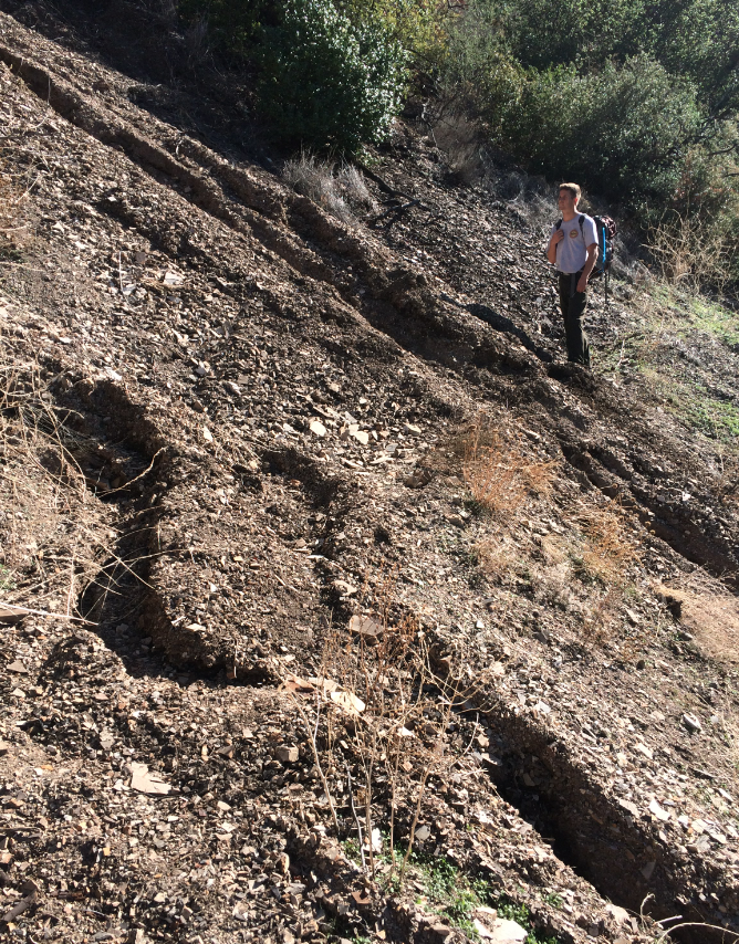
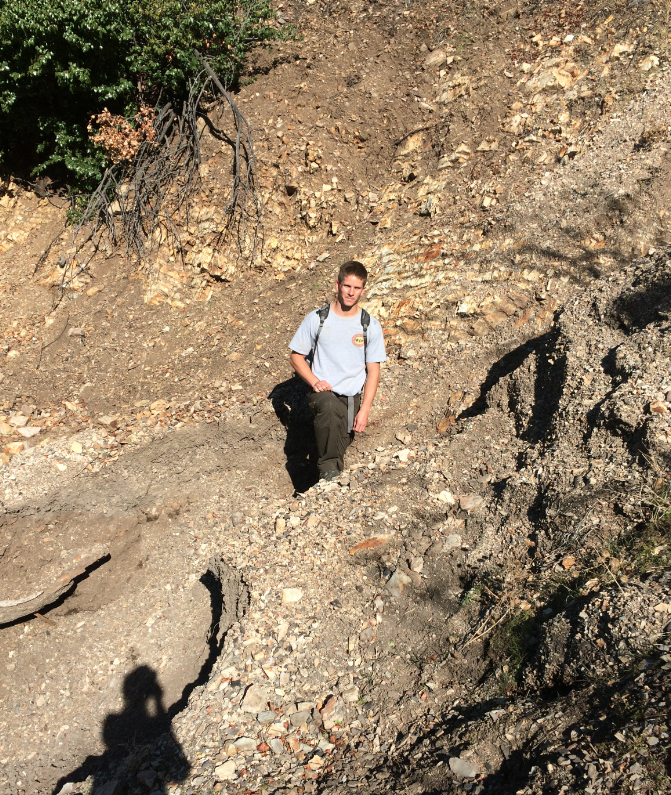
Santa Cruz Trail Survey - 02-28-2019 - by Los Padres Forest Association| Link: | Santa Cruz Trail |
| Date: | 02-28-2019 |
| Surveyor Name: | Los Padres Forest Association |
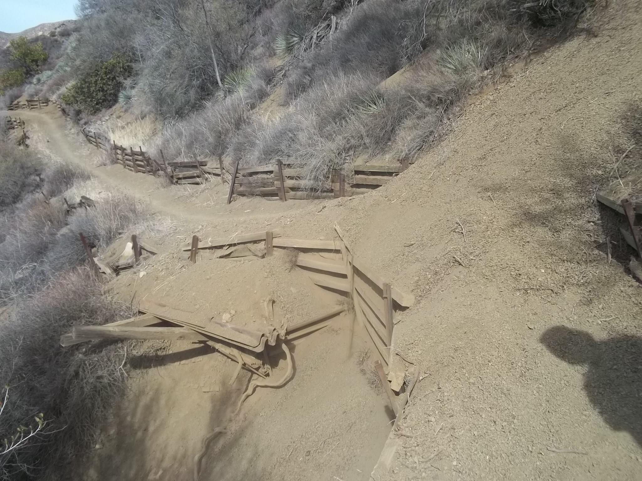
| Trail description: | LPFA Trail Survey from Coche Camp down to Alexander Saddle: 1) From Coche to Flores is overgrown with a dozen or so downed trees blocking the trail. Not hard to follow but expect to bob and wave a bit as you pass through. 2) Flores to the wilderness boundary was open and in good shape but has been overgrown by mustard later in the season. 3) Wilderness boundary to Santa Cruz Station in good shape, a bit hard to follow through Romo Potrero but once on the trail very easy to follow. This is one of the more exceptional designed trails in the Southern Los Padres. 4) Santa Cruz to lower 40-Mile Wall has a handful of downed trees and needs lots of tread work but is followable and safe. 5) 40 Mile Wall was a bit sketchy with long sections of no tread with steep drops and exposure. Didn't help that we hiked it in the rain when the grass was wet and slippery. Some of the cribwalls have failed. 6) Upper 40-Mile Wall to Little Pine Spring had a few downed trees and some encroaching brush, the meadow just below Little Pine Spring is always sloggy and hard to follow but not too bad. 7) Little Pine Spring to Alexander Saddle was burned in the Rey Fire and was in SKETCHY shape during the rain storm. No tread with 10-15ft drops in places, scrambling on all fours. Happy to get to Alexander Saddle and chose to hike the road back rather than the front side of SC in a storm. |
| Mode of transport: | Hike |
| Trail condition: | Needs some work |
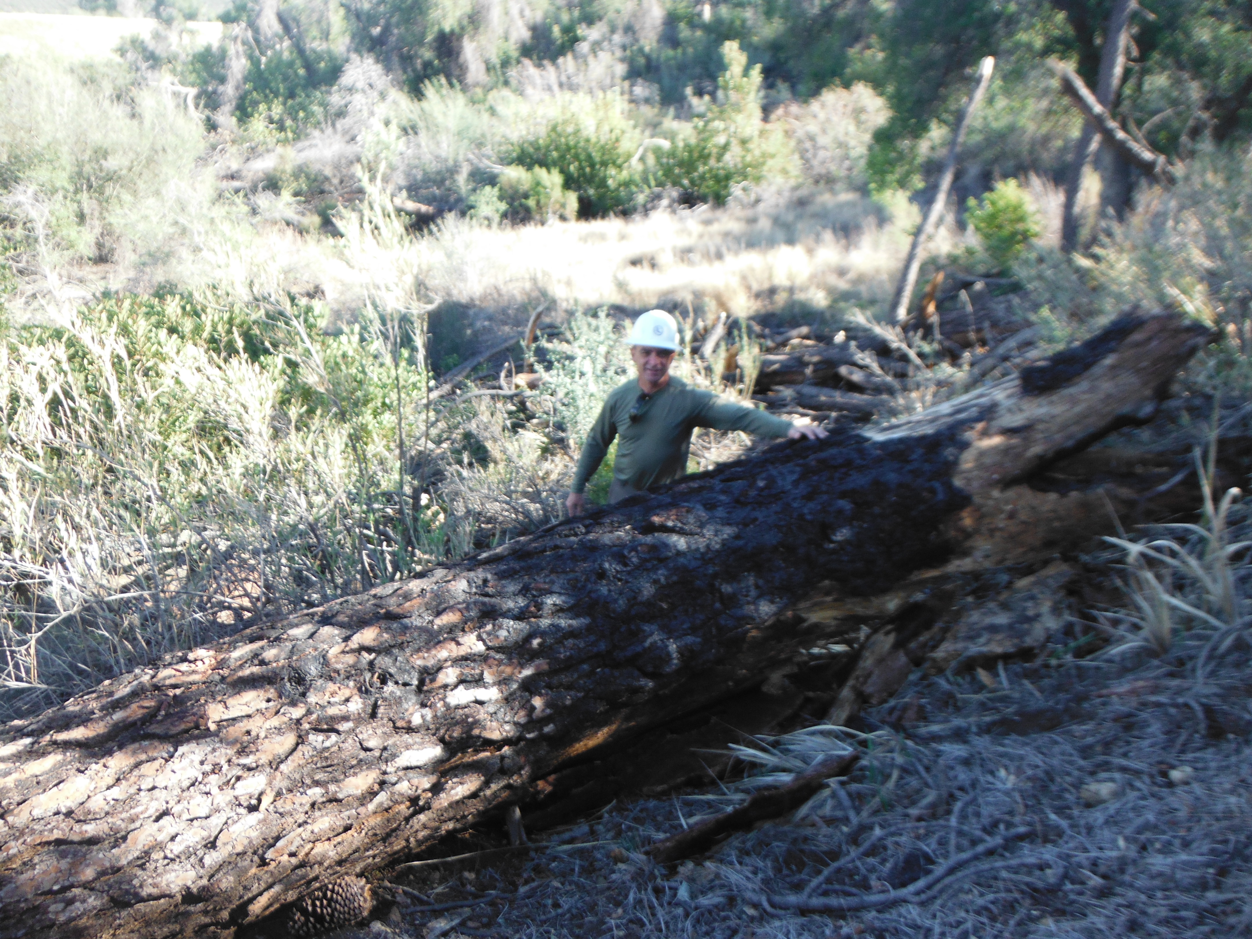
| Images: | Downed tree along middle section of Santa Cruz between Coche and Flores. Nice view of upper Santa Cruz Drainage near climb towards wilderness boundary. "Trail" down Romo Potrero from the wilderness boundary headed towards the Station 40-Mile Wall looking sketchy, steep, narrow, slippery and nerve racking. Santa Cruz Trail near Alexander Saddle in the Rey Fire area. Scrambling on all fours, leaping - not good place to be in a storm. |
Santa Cruz Trail Survey - 07-28-2019 - by Los Padres Forest Association| Link: | Santa Cruz Trail |
| Date: | 07-28-2019 |
| Surveyor Name: | Los Padres Forest Association |
| Trail description: | Article in EdHat discussing a Search and Rescue operation along the Santa Cruz Trail between Little Pine Spring and SC Station. Enjoy! |
| Mode of transport: | Array |
| Trail condition: | Hard to follow |
Santa Cruz Trail Survey - 05-15-2019 - by FP| Link: | Santa Cruz Trail |
| Date: | 05-15-2019 |
| Surveyor Name: | FP |
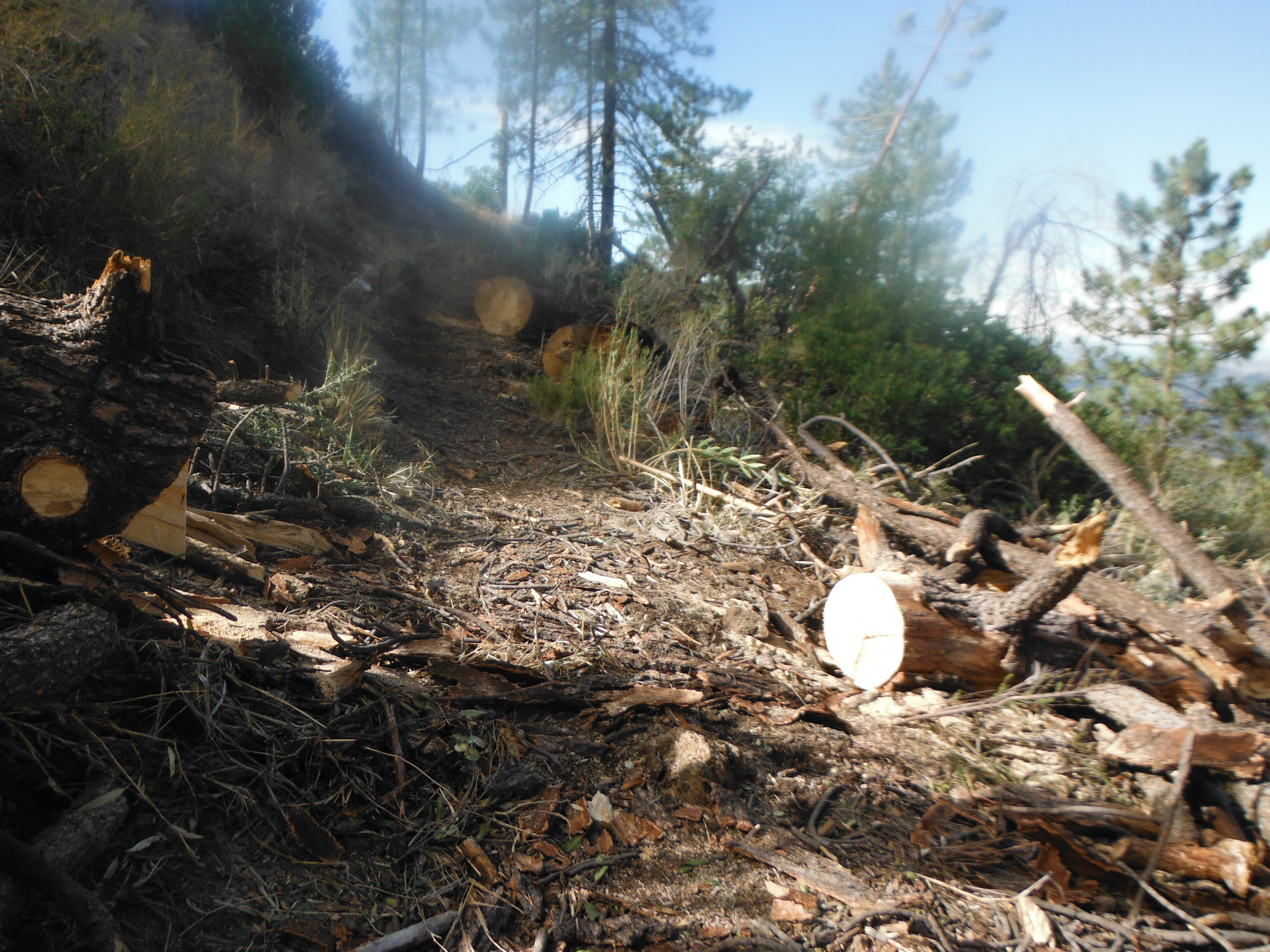
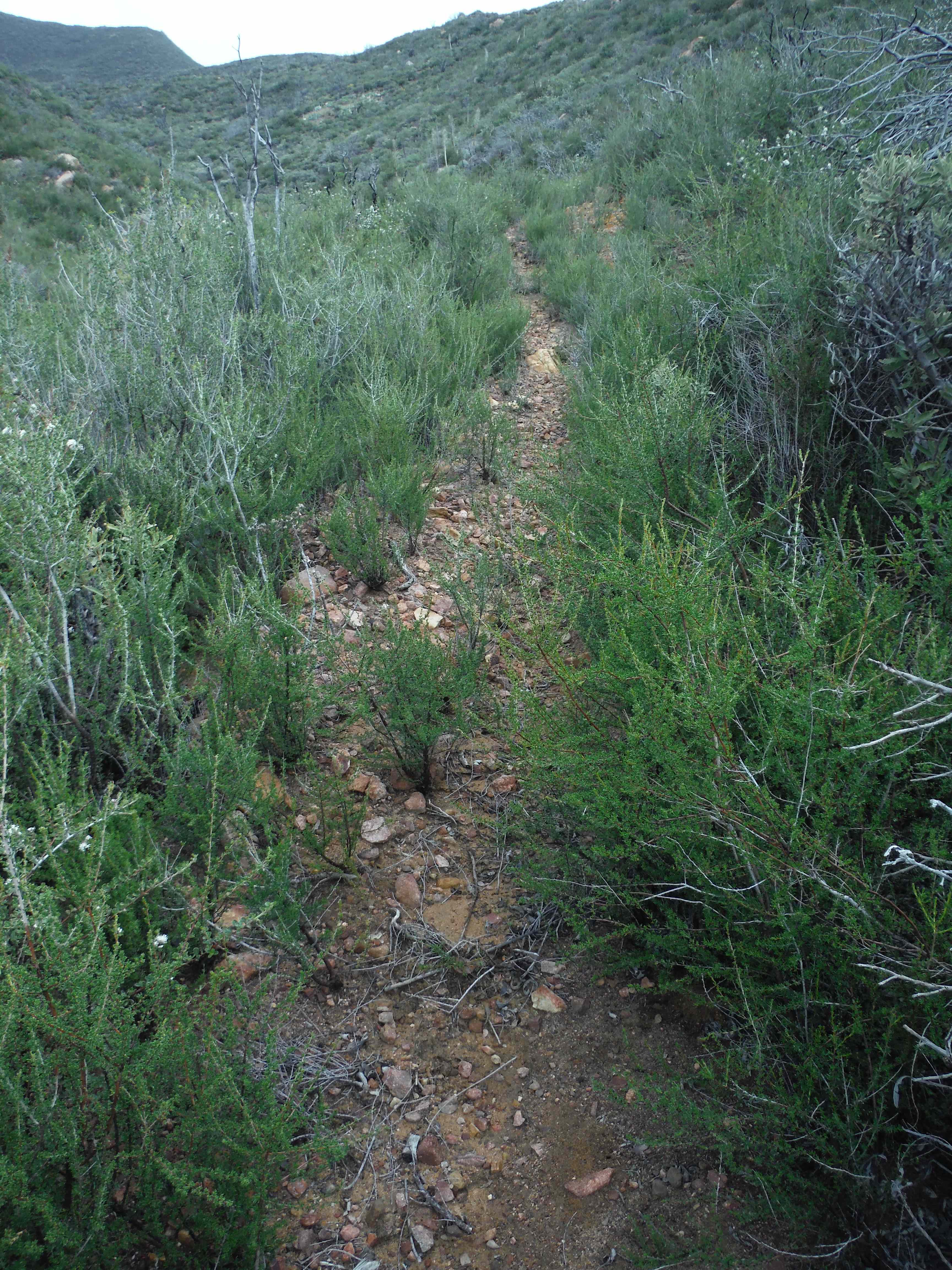
| Trail description: | Trail has some areas that are somewhat tricky and hazardous to negotiate, but it's "doable" with sufficient determination and caution. Today (May 15, 2019) there is also quite a bit of vegetation growth in several sections which make it somewhat difficult to walk, but the trail can still be followed relatively easy. I turned back about half way up Little Pine Mountain, so I don't know what all that other section looks like, although from previous years, before the fire and subsequent mud slides, most of that area is not prone to as many slides as the first part. |
| Mode of transport: | Hike |
| Trail condition: | Needs some work |
| Images: | Section about 2 miles past 19 Oaks trail fork on the way to Little Pine Mountain. |
Santa Cruz Trail Survey - 11-25-2018 - by Los Padres Forest Association| Link: | Santa Cruz Trail |
| Date: | 11-25-2018 |
| Surveyor Name: | Los Padres Forest Association |
| Trail description: | Report from a LPFA backpacker survey from Upper Oso to Santa Cruz Guard Station: As you know in many places it has hard packed
slides, loose slippery slides, wash outs, blow outs, narrow tread, rocky
tread, slippery side hills etc. BUT it is hikeable and much more stable
than last year. There are several trees (6) needing a chain saw: all
between the Guard Station and the ‘wall’. More than last year when I
hiked in. I even met two backpackers who went from NIRA to Mission Pine, Coche and out to Upper Oso. They reported that the trail from coche to the Guard Station was especially difficult. Only standing puddles at Santa Cruz Station. |
| Mode of transport: | Hike |
| Trail condition: | Needs some work |
Santa Cruz Trail Survey - 09-22-2017 - by Mt Biker Russ| Link: | Santa Cruz Trail |
| Date: | 09-22-2017 |
| Surveyor Name: | Mt Biker Russ |
| Trail description: | Rode up Cameusa trail from Paradise road, decided to check out our well-paid forestry department has done to fix the Santa Cruz trail from Happy Hollow down to Upper Oso. Going down the face of little Pine was not too bad, switchbacks had some overgrowth, but turning left at the saddle proved a big mistake. The erosion took the trail width to barely hike able. In this runoff silt had grown very thick mustard plants, now dried up from a long, hot summer, so maneuvering a bike down this trail was torturous at best! These conditions prevailed through the large grass and poppy fields, then transitioned into miles of fist-sized rocks and a sandy/dirt erosion areas, then the gullies came! Most could be traversed, but at least one was a climb into, toss bike onto, climb out of type gully caused by downpours in the previous spring storms. Surviving my way along I came to the Crib wall area. Seeing some horse (or bear) tracks that went along the sand dune-like mountain face required a bit of mental preparation as to how I would sprint across this section with my bike and live to tell about it. The following few miles were laced with more risky erosions, loose rocks and beach-like sand making the Happy Hollow section to 19 Oaks very unpleasant, even for the thrill seeker! Where the trail crosses the Chalk Wall Creek at 19 Oaks is wasted, and not ride-able to cross the creek.  From 19 oaks and back to Buckhorn Rd was a breeze and signs of good trail repair work. I use to be able to ride from Happy Hollow to Upper Oso CG in 40 mins, but this day took almost 2 hours and left my legs bleeding and scared. I hope the LPF repair crews can repair this trail before 2020!!! (Maybe this part of the trail needs to be abandon using the ridge that goes from the Alexander Saddle, west and down to 19 oaks? There's an old road on part of this) |
| Mode of transport: | Bicycle |
| Trail condition: | Hard to follow |
| Condition details: | 75% of the trail is wasted from the saddle to 19 Oaks |
| Images: | Little Pine before the Rey Fire. Possible new route? |
Santa Cruz Trail Survey - 12-31-2017 - by Los Padres Forest Association| Link: | Santa Cruz Trail |
| Date: | 12-31-2017 |
| Surveyor Name: | Los Padres Forest Association |
| Trail description: | 2017 was a busy year for the LPFA along the Santa Cruz Trail. We were fortunate to receive multiple grants from REI and the Sierra Club as well as working with SBMTV to help the trail. We worked multiple projects including National Trails Day to help open the trail up to 19 Oaks Camp. National Trails Day was really fun with a party and BBQ afterwards at Rancho Oso! From there funds were used with the help of Chris Orr to open the trail up to the meadow commonly referred to Dead Dog Meadow, which is about 3/4mile above 19 Oaks. 19 Oaks also got a facelift (new table, new toilet, new fire ring) thanks to a LPFA partnership with a local Goleta area scout troop. You can read more about the NTD project here thanks to ValHikes: http://valhikes.blogspot.com/2017/06/santa-cruz-trail-work.html?utm_source=feedburner&utm_medium=email&utm_campaign=Feed%3A+MomentsInDirtAndInk+%28Moments+in+Dirt+and+Ink%29 The trail is still not passable above Dead Dog Meadow but efforts will resume this winter to hopefully get the trail reopened again. |
| Mode of transport: | Array |
| Trail condition: | Needs some work |
| Images: | National Trails Day volunteer below 19 Oaks Chris Orr's mini-ex flexing above 19 Oaks NTD BBQ! Hungry anyone? Thanks to Hollister Brewing for donating the beer for the after party. |
Santa Cruz Trail Survey - 06-18-2018 - by Valerie Norton| Link: | Santa Cruz Trail |
| Date: | 06-18-2018 |
| Surveyor Name: | Valerie Norton |
| Trail description: | I hiked the trail from the junction with the fire trail to Alexander Saddle. (The Santa Cruz Fire Trail does not seem to be an object on here. The thing really needs someone to come down it with a chain saw. Or at least some flagging, especially for the nice switchback folks are missing when coming down and the flatter areas. Not quite a total suffer fest. People are using it and there is a track where the brush gets regularly broken back by people passing.) From the junction south to the station: There was a tree, but with a quick grab and pull, it is now at the side of the trail instead of across at thigh height. Might look into reinforcing some of the spots where it crosses gullies. Seems real nice. From station to ridge: There are 7 trees, mostly small and easy (but not so easy as the previous tree) but some large and complicated. Can supply pictures. Forty Mile Wall: The grass makes it hard to see if I am stepping on trail or space, but what are you going to do? A couple trees (but no pics) and a couple gully washers where hard dirt and an uncomfortable slope exists instead of trail. Also saw a little mama bear and her two tiny cubs! Creek-ish to Little Pine Spring: Poison oak getting handsy at first area. Meadow areas are tough. Narrow to no tread and tripping on mustard stems and slipping on straw is not fun. Landed on my knee a number of times, but the straw is a soft landing. The trail jogs suddenly down 10 feet (or up if you are coming from the other direction) so the tracks must be going wrong somewhere... Little Pine Spring sign almost eaten by the brush. Little Pine to the saddle: Starts off well. Then more of the gully washers leaving hard, slanted dirt to cross. Then the land slides. These are soft, so my feet stayed where I put them, but over a quarter mile of it with no breaks gets one worried in all sorts of ways. Like, "am I going to die?" ways. But at least I got short bits to try it out before the long bit. If I'd come the other way, I would have just launched into the long, crazy hard trudge that would have felt quite endless. Anyway. Not recommended. 'Course, good luck finding that trail up from Little Pine Spring to Happy Hollow to use instead. I sure didn't see it. After the saddle, the signs marking the closure seem to be blank. It looked like there were many land slides across the trail and they didn't even have as many footsteps across as the bit I did had. |
| Mode of transport: | Hike |
| Trail condition: | Needs some work |
| Condition details: | trees down near station, gullies washed out, landslides near Alexander Saddle |
Santa Cruz Trail Survey - 05-16-2014 - by Los Padres Forest Association| Link: | Santa Cruz Trail |
| Date: | 05-16-2014 |
| Surveyor Name: | Los Padres Forest Association |
| Trail description: | LPFA Working Vacation cleared the Santa Cruz Trail from the Guard Station to Coche Camp. All trees and brush cleared. |
| Mode of transport: | Hike |
| Trail condition: | Needs some work |
| Images: | Group photo at Santa Cruz Station, which was the basecamp for the hot week Post work trail view, photo Beckstrand All work and no play makes......; you know the rest |
Santa Cruz Trail Survey - 11-20-2017 - by Los Padres Forest Association| Link: | Santa Cruz Trail |
| Date: | 11-20-2017 |
| Surveyor Name: | Los Padres Forest Association |
| Trail description: | VWR patrol from Upper Oso to Santa Cruz Station. The trail remains difficult and dangerous but passable through the Rey Fire burn areas, in particular the 'Legolas Section' just north of Alexander Saddle. There are 5-6 downed trees on the final switchbacks down to the Station. The 40 Mile Wall has a few slides that are not stock passable. Signs of lots of bear along the trail. The meadow at Little Pine Spring is not clearly marked, as usual. Not much human use at the moment. Good water at SC Station, cabin is intact. We cleaned up the area, removed a fallen oak near camp, painted some bear damaged areas and performed the usual annual pre-winter maintenance on the cabin. |
| Mode of transport: | Hike |
| Trail condition: | Hard to follow |
Santa Cruz Trail Survey - 11-19-2016 - by Los Padres Forest Association| Link: | Santa Cruz Trail |
| Date: | 11-19-2016 |
| Surveyor Name: | Los Padres Forest Association |
| Trail description: | LPFA scouted the Santa Cruz Trail to assess and document damage from Upper Oso to Little Pine post Rey Fire. Â There are extensive slides covering the trail almost never-ending. Â The BAER teams have removed most of the dead fallen trees but we'd expect more to come at any time, that is where there are still trees. Â There was water flowing in Oso Creek below 19 Oaks. Â 19 Oaks was annihilated but amazingly one of the tables survive, the new crapper wasn't so lucky. Â The slides progressively get sketchier above Dead Dog Meadow with exposure and very uneven ground. Â Don't even think about riding your bike. Â The cribwall section is not looking good. Â It felt like 3/4 of the wood support burned but is still somehow holding together. Â That being said it felt like it could fail altogether at any moment. Â We basically had to run through that section and hope it wasn't our time. Â Above the cribwalls the trail remains bad with sections that look like someone took a giant eraser and wiped the trail off the side of the mountain. Â The cattle trough is gone, burned and melted, although there is still a seep water at the spring box. Â Portions of the upper mile of trail did not burn. Â Heading down towards Little Pine Spring felt the sketchiest and we opted not to go that way, instead climbing to Little Pine and Happy Hollow. Â Happy Hollow fared quite well and may have been part of a backburn operation. Â It is a mess of dozer tread around the bowl but most of the surviving trees from Zaca remain alive. Â It needs time to come back. Â All in all quite depressing and a lot of work needed to bring this trail back. Â But more than anything it will need time. Â What we learned from Zaca is that it takes a few years (3-5 depending) for the earth to settle and plants to regrow to the point where they can support a trail again. Â But we'll chip away and do what we can to bring it back when the time is right. |
| Mode of transport: | Hike |
| Trail condition: | Non existent |
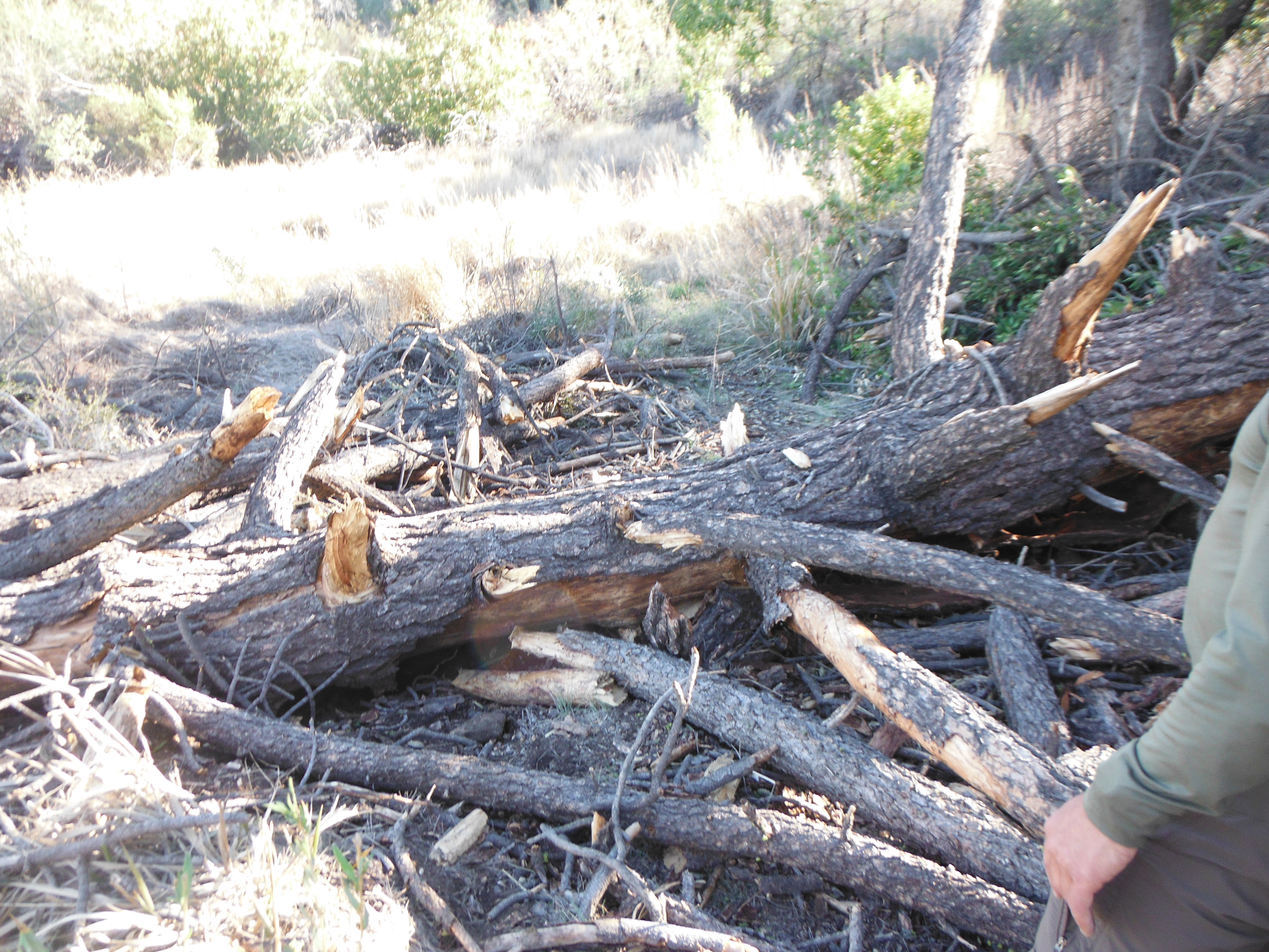
| Images: | View looking down at 19 Oaks from below Dead Dog Meadow. Slides above Dead Dog Meadow. This section was one of the worst with football size rocks. The view of the suspended cribwalls. The cribwalls. Half burned and failing. Bet you don't recognize this? It's the horse trough section of the Santa Cruz Trail. Trough melted. |
Santa Cruz Trail Survey - 10-31-2016 - by Los Padres Forest Association| Link: | Santa Cruz Trail |
| Date: | 10-31-2016 |
| Surveyor Name: | Los Padres Forest Association |
| Trail description: | LPFA Working Vacation based out of Mission Pine Basin worked the top mile of the Santa Cruz Trail from Mission Pine Basin down to where the ACE crew wrapped up work in 2015. Â The trail is in really fine shape at the moment. Â No water at Mission Pine Basin. Photos of the whole Working Vacation here: https://www.facebook.com/LosPadresForestAssociation/posts/619910411467220?notif_t=like¬if_id=1481555349387696 |
| Mode of transport: | Array |
| Trail condition: | Needs some work |
Santa Cruz Trail Survey - 08-04-2016 - by Los Padres Forest Association| Link: | Santa Cruz Trail |
| Date: | 08-04-2016 |
| Surveyor Name: | Los Padres Forest Association |
| Trail description: | REPORT FROM RECENT MTN BIKER: - Santa Cruz Trail from Little Pine to Upper Oso is in fine shape other than the usual shale slides along the south face and the white rock slides a little further down before Dead Dog Meadow. - There is still a trickle of water in the 1mile stock trough. |
| Mode of transport: | Bicycle |
| Trail condition: | Needs some work |
| Images: | Photo Noe |
Santa Cruz Trail Survey - 05-15-2015 - by Los Padres Forest Association| Link: | Santa Cruz Trail |
| Date: | 05-15-2015 |
| Surveyor Name: | Los Padres Forest Association |
| Trail description: | The LPFA in partnership with the Forest Service hired an American Conservation Experience (ACE) crew to work the Santa Cruz Trail from Kellogg Camp up towards Mission Pine Basin. Â They accomplished 3.11 miles of trail work, clearing what was once a brush slog into a great wilderness trail once again. More information here: https://www.facebook.com/LosPadresForestAssociation/posts/464739166984346 |
| Mode of transport: | Array |
| Trail condition: | Needs some work |
Santa Cruz Trail Survey - 01-01-2016 - by BeccaVT| Link: | Santa Cruz Trail |
| Date: | 01-01-2016 |
| Surveyor Name: | BeccaVT |
| Trail description: | We camped in the Little Pine Spring camp, which happily still had running water, so we could stay in the area for an extra night (otherwise we would have used up everything we packed in). However, it's pretty clear this is the only water around for miles; the creeks are totally dry. Because of that, the spring is probably the main water source for animals in the area. We saw relatively fresh tracks, and are pretty sure we heard a large-ish animal walking around the camp at night, crunching on all the dry leaves. My guess based on the tracks is either a coyote or a bobcat. We moved camp up closer to the saddle the second night, to avoid 1) potentially meeting/surprising said animal, or 2) scaring it away from its water source. The trail down to Little Pine Spring is very eroded and sandy, and also very steep. We basically had to slide down the trail, using our trekking poles like ski poles. With the rain coming this week, it will almost certainly completely wash out. It's also pretty hard to follow in places - there are several false turns. In some places there are blue ribbons tied to the brush to guide the way, but they could be much better. |
| Mode of transport: | Hike |
| Trail condition: | Needs some work |
| Condition details: | There are several places on the trail that are very sandy/eroded and are likely to wash completely out with the rain this week. |
Santa Cruz Trail Survey - 01-02-2016 - by Los Padres Forest Association| Link: | Santa Cruz Trail |
| Date: | 01-02-2016 |
| Surveyor Name: | Los Padres Forest Association |
| Trail description: | Report from Susie T: - Hiked from Upper Oso to Santa Cruz Station - The trail tread was in generally in good shape thanks to the LPFA work done this year. Rideable and hikeable. - There
are 6 areas on the 40 Mile Wall that are probably going to completely wash out
with the next rain. At the present time they are just narrow
areas, almost washed out but are hikeable. They are all in the center of
the “40 Mile wall’. - All the cribbed areas are holding well. - There are about 6 gaps and holes in the tread along the front side of Little Pine at the scree slides. - The
slides on the Big Crib Wall are the same as always…no better…no worse.
The uphill cribbing is still collapsing inwards onto the trail. - No brushing needed. Just two overhanging branches that I couldn’t reach. |
| Mode of transport: | Array |
| Trail condition: | Needs some work |
Santa Cruz Trail Survey - 05-09-2015 - by Jeff B.| Link: | Santa Cruz Trail |
| Date: | 05-09-2015 |
| Surveyor Name: | Jeff B. |
| Trail description: | Rode the Santa Cruz singletrack from the junction with Camuesa Road up to Alexander Saddle, then continued on down to Santa Cruz Camp and returned the same way. The trail is in great shape for it's entire length, with the 40 Mile Wall section being a particular highlight. Also, it's well worth the short trek down to Little Pine Spring. |
| Mode of transport: | Bicycle |
| Trail condition: | Good shape and easy to follow |
| Images: | |
Santa Cruz Trail Survey - 02-28-2015 - by Los Padres Forest Association| Link: | Santa Cruz Trail |
| Date: | 02-28-2015 |
| Surveyor Name: | Los Padres Forest Association |
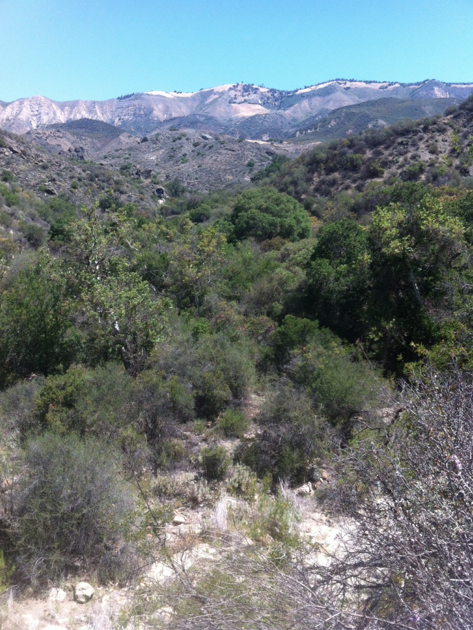
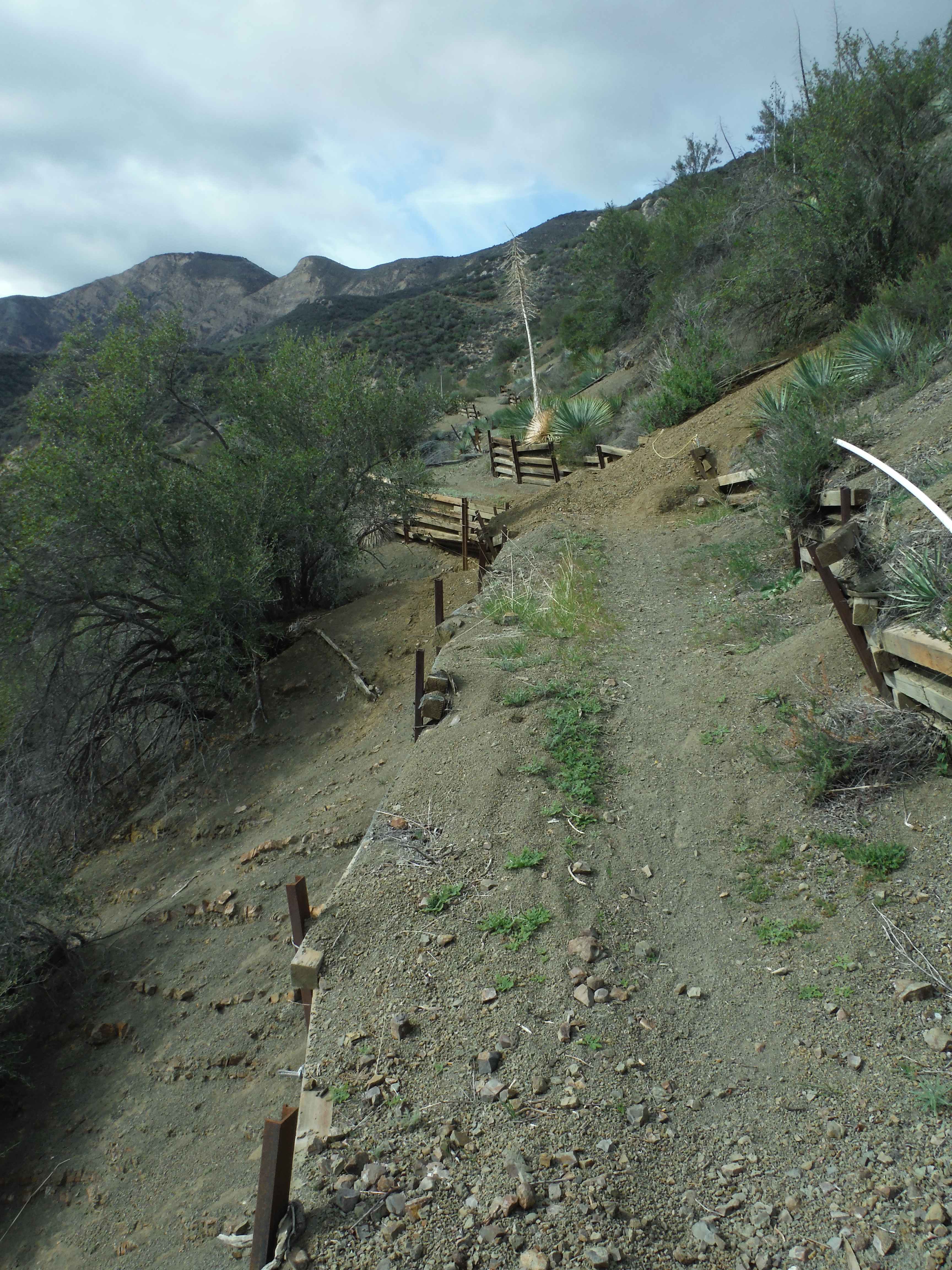
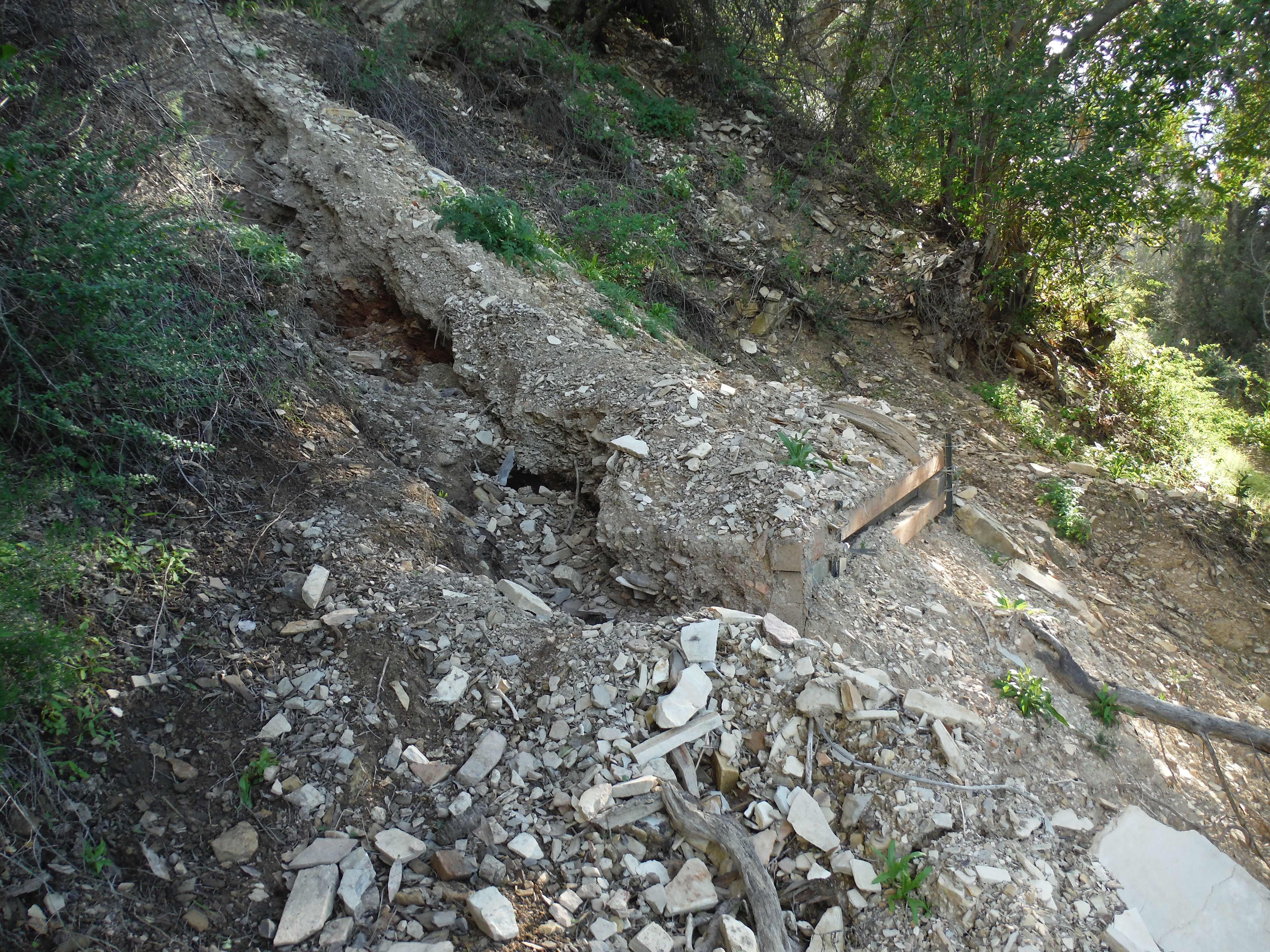
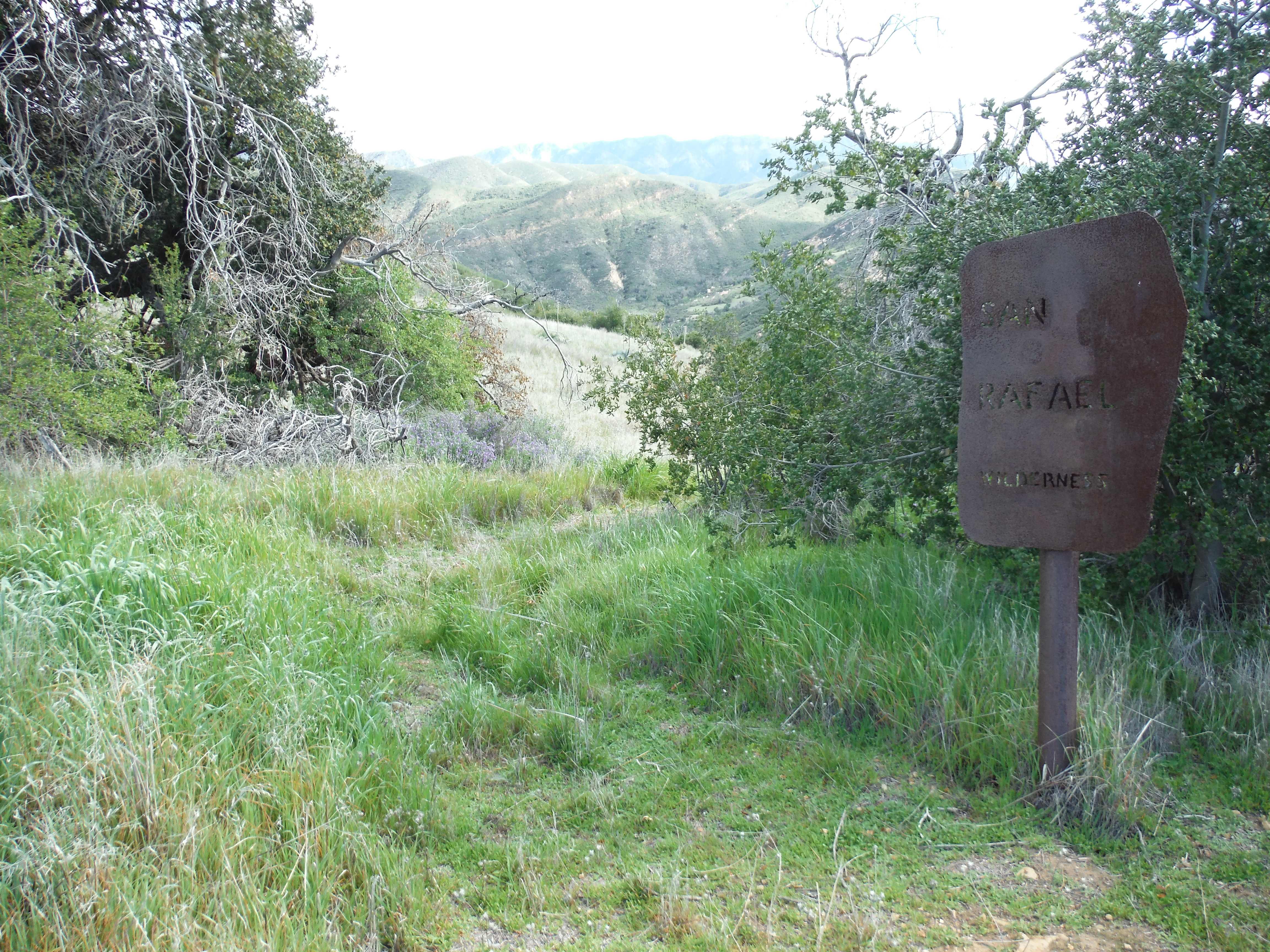
| Trail description: | Complete report of the Santa Cruz Trail from Upper Oso to Mission Pine Basin: I. UPPER OSO TO ALEXANDER SADDLE Trail is in typical good shape. Â There is water along the lower creek sections and most of the larger tributaries. Â There is water within the stock trough (1 mile below the saddle) but that could use a good spring flushing. Â The slides continue to do their thing and the rope that was installed last year remains in good shape. Â IMO the slides were in better shape than normal, perhaps the rope is getting people to take the same course and as a result the steps are holding a bit better. II. ALEXANDER SADDLE TO SANTA CRUZ STATION Very passable and followable. Â Should not cause any problems for hikers. Â Most of the larger deadfalls were logged out last month by LPFA volunteers. Â There is one tree remaining just before you start the 40 Mile Wall. Â There are about 5 slides that will prevent stock passage. Â The first is on the backside of Little Pine and the rest occur sporadically along the 40 Mile Wall. Â The LPFA has a project scheduled this weekend (3/14) to clean out these slides. Â III. SC STATION to GRAPEVINE TRAIL JUNCTION The trail leaving the Station and up to the wilderness boundary is in fine shape. Â There is a newish cattle guard as you enter Romo Potrero. Â Some of the grasses are going to be quite high by the end of spring but the route is not difficult to follow. Â Heading down towards Flores the grass along the tread continues to grow better than elsewhere. Â I would love to know how to stop grass from growing on the nice flat tread - perhaps if it was walked on more often. Â No obstacles to Flores. Â From Flores to Grapevine there are 9 downed trees. Â The trees range from 6-24inches in diameter. Â The LPFA has a project planned the last week of April to clear these trees. Â No other obstacles. Â The trail does get quite a bit thinner the farther you get away from Upper Oso. IV. GRAPEVINE TO MISSION PINE BASIN Here is where the trail gets overgrown. Â First off, don't bother camping at Coche, it is overgrown and should be removed. Â The relatively new Kellogg Camp (1/4mile down from the Grapvine Junction) is far superior. Â As the trail climbs up the San Rafael Mtns it gets worse and worse. Â The tread is followable but there are sections where you'll be swimming through chest high brush. Â There is one turn that is hard to see but flagging should help. Â We placed a few new flags to help along the way. Â Once you climb out of the chaparral and into the conifer zone there are a few downed pines that need sawyer work. Â These are in the 30" range. Â The final drop to Mission Pine Basin is marked with cairns. Â The trail is followable but expect to push through some brush. Â The LPFA is planning a week long trip to clear the brush along the climb in April. Â |
| Mode of transport: | Hike |
| Trail condition: | Needs some work |
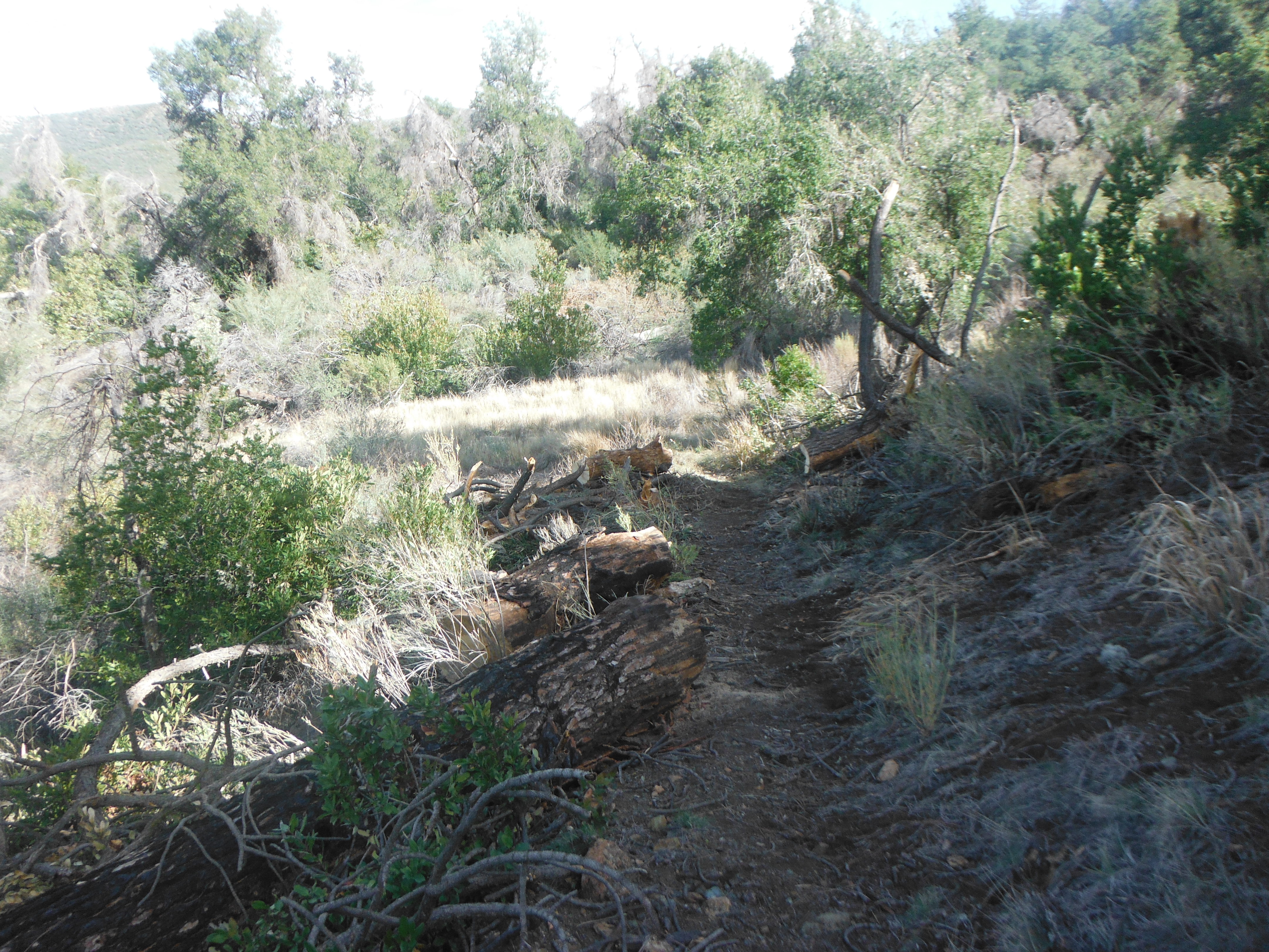
| Images: | Scree slide along the front of Little Pine The largest washout along the back (north) of Little Pine Entering the San Rafael atop Romo Potrero The largest tree along the trail between Flores and Kellogg Typical section of trail climbing up to Mission Pine Basin |
Santa Cruz Trail Survey - 02-06-2015 - by Curt Cragg| Link: | Santa Cruz Trail |
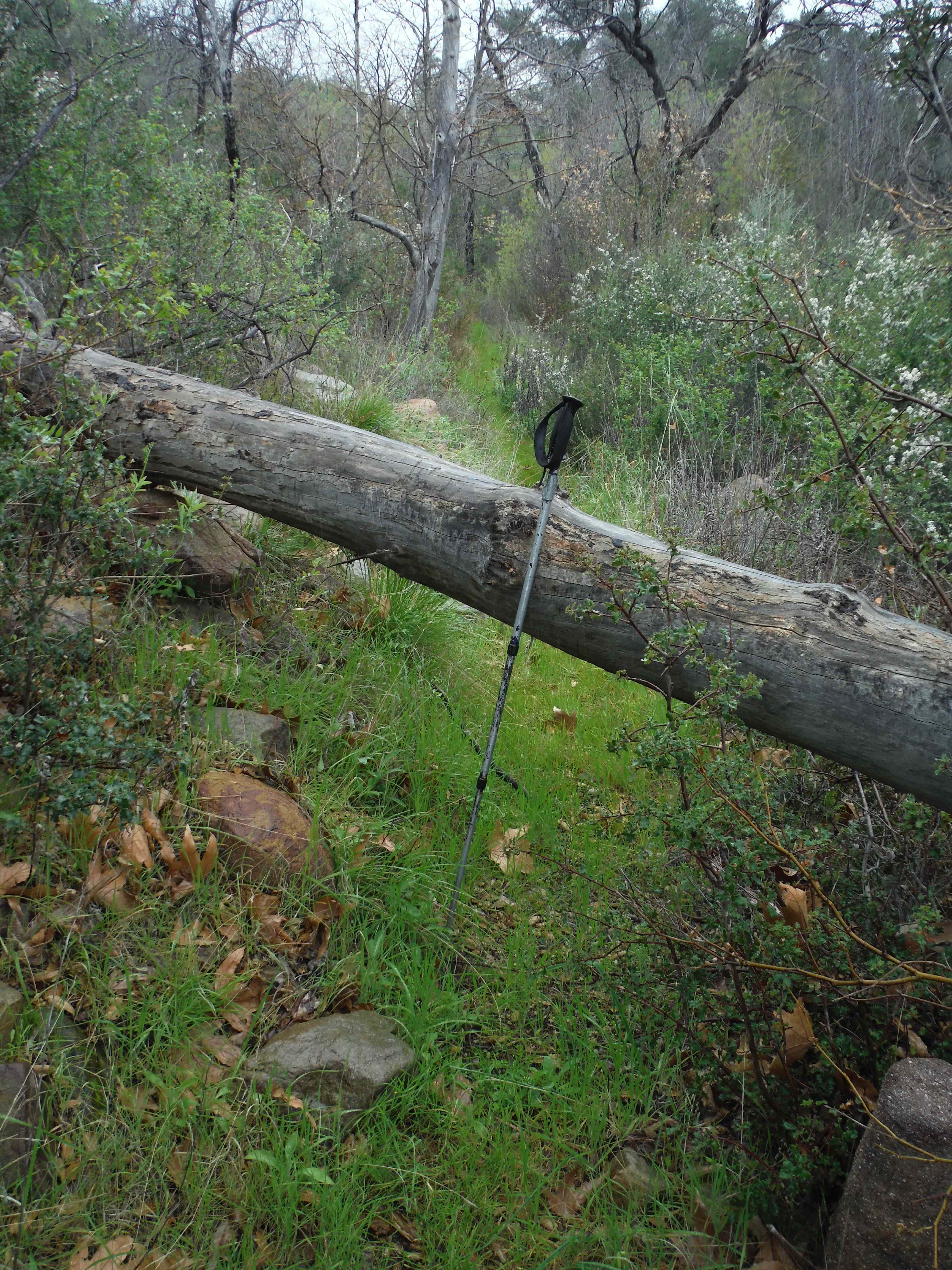
| Date: | 02-06-2015 |
| Surveyor Name: | Curt Cragg |
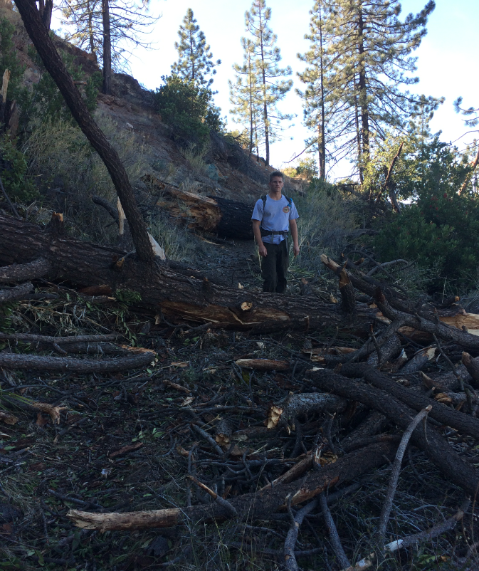
| Trail description: | Cleared two pine trees as reported in earlier trail surveys and shown in photos. Â Check out trail to Little Pine Spring Camp for possible future trail project to clear brush and reroute current work around trail back to original route |
| Mode of transport: | Hike |
| Trail condition: | Needs some work |
| Condition details: | Santa Cruz Trail just before Little Pine Spring Junction |
| Images: | Large pine fall on trail as previously reported Trees and tree debris cleared from trail. Second pine fall and debris Clear sailing for hikers, bikers and pack stock in this area |
Santa Cruz Trail Survey - 12-28-2014 - by Los Padres Forest Association| Link: | Santa Cruz Trail |
| Date: | 12-28-2014 |
| Surveyor Name: | Los Padres Forest Association |
| Trail description: | VWR Survey of the Santa Cruz Trail from Upper Oso to Santa Cruz Guard Station. Â Led by VWR Susie - Large downed trees just above the turnoff for Little Pine Spring - Lots of slides along the backside of Little Pine heading into and through the 40 Mile Wall TRAIL IS CURRENTLY NOT PASSABLE FOR STOCK |
| Mode of transport: | Hike |
| Trail condition: | Needs some work |
| Images: | |
Santa Cruz Trail Survey - 01-18-2015 - by FP| Link: | Santa Cruz Trail |
| Date: | 01-18-2015 |
| Surveyor Name: | FP |
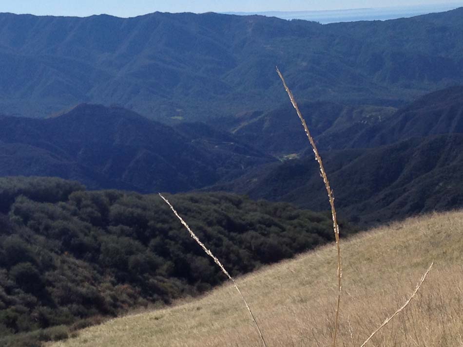
| Trail description: | Beautiful views from this trail, and fantastic ones from the summit of Little Pine Mtn. I hiked it from Upper Oso to Little Pine Mtn. A word of caution: this trail can be extremely hot during the summer. It's best done in the winter. The views are much clearer in the winter, too. It's about a 12-14 mile round trip hike (depending on how much you explore while at the top (Happy Hollow Camp, front views, back views, etc.) so start early and give yourself enough daylight. |
| Mode of transport: | Hike |
| Trail condition: | Good shape and easy to follow |
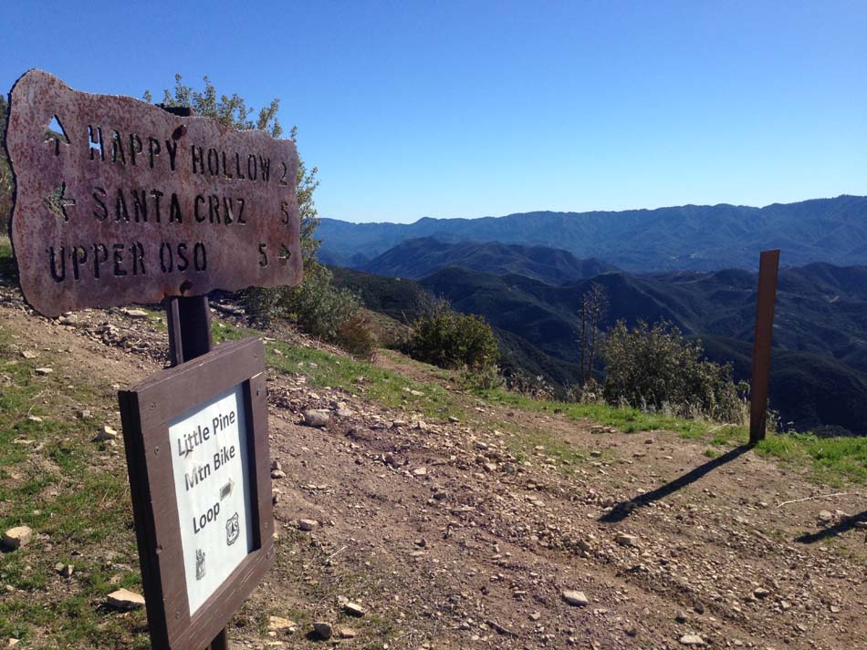
| Images: | approaching Alexander Saddle Descending from Little Pine Mtn. summit Alexander Saddle trail marker |
Santa Cruz Trail Survey - 06-08-2014 - by Los Padres Forest Association| Link: | Santa Cruz Trail |
| Date: | 06-08-2014 |
| Surveyor Name: | Los Padres Forest Association |
| Trail description: | The Santa Cruz Trail is in good shape but we could not find our way down to Little Pine Spring Camp. Â It was very overgrown
and the trail didn’t exist anymore behind the sign that said “Little
Pine Springs ¼ miâ€. We got there about mid-day, so it was very hot.Â
There were some footprints in the loose dirt, but we hiked down what
seemed like a quarter mile and didn’t find a single break between the
dense brush. We even went back up the trail and went down the bare
ridge on the other (west) side of the ravine where the spring was
supposed to be and couldn’t find it. So we gave up. |
| Mode of transport: | Hike |
| Trail condition: | Needs some work |
Santa Cruz Trail Survey - 06-14-2014 - by Los Padres Forest Association| Link: | Santa Cruz Trail |
| Date: | 06-14-2014 |
| Surveyor Name: | Los Padres Forest Association |
| Trail description: | The trail is in great shape from Upper Oso up to Little Pine. Â The slide section continues to do its thing but is very passable. Â Water will be the larger concern for summer/fall 2014. Â The creek is just a trickle for most of the way from Upper Oso up to 19 Oaks and will no doubt go dry later this year. Â No water at 19Oaks Camp. Â There was water in the spring about a mile below Alexander Saddle. |
| Mode of transport: | Hike |
| Trail condition: | Good shape and easy to follow |
| People Seen: | 8 |
| Images: | |
Santa Cruz Trail Survey - 01-12-2014 - by toejam| Link: | Santa Cruz Trail |
| Date: | 01-12-2014 |
| Surveyor Name: | toejam |
| Trail description: | Hiked the trail from Mission Pine Basin to Upper Oso over two days.Upper Santa Cruz Trail is very brushy but not hard to follow. Trail disappears crossing a meadow in Mission Pine Basin. Small rock cairns mark the trail on the other side of the meadow. Thorny ceonothus tears at the legs of hikers once the trail leaves the basin and heads downhill. The brush is mostly not too tall and the old roadbed is mostly obvious. Tread is narrow and rough. One of our party got a blister in this section that I attribute to the rough trail. Left some flagging when I thought it would help. The view is really good. Good, flowing water in Coche Creek. Coche Camp consists of a metal sign and a couple of ice cans under some trees. It doesn’t look like it’s been used in quite a while, and it would take considerable clean up to make usable. Kellogg Camp was recently used by a party with stock. There is a homemade table and large fire ring. No shovel. Good access to flowing water. Stock had been tied in a shady area a little way down the trail. Santa Cruz Trail is in very good condition past intersection with Grapevine Trail. But brush & roses are poised to grow back quickly when it rains. Bear tracks & scat at a couple of places between Kellogg & Flores Flat. Flowing water at Flores Flat Camp. Camp has a large fire ring with no shovel. Trail from Flores Flat to Santa Cruz Station is in very good condition. Water flowing well behind cabin. Some small trees have fallen in the creek and should be removed. Santa Cruz Guard Station in good shape. There are 4 picnic tables by the cabin, a shovel in the fire ring, and lots of firewood stacked neatly. Nearby campsites include 3 fire rings & 2 picnic tables. No shovels. A small amount of trash. Black Canyon campsite has a fire ring & grill – appears to have been used recently. Trail to Alexander Saddle in very good condition. The tread is mostly in very good shape with a couple of slides. The trail is wide and very obvious in the brushy area above the 40-Mile Wall. There is a discernable path to Little Pine Spring, which will disappear when new grass grows. Alexander Saddle to Upper Oso has been worked and gets a lot of foot and bike traffic. A couple of scary slides persist. |
| Mode of transport: | Hike |
| Trail condition: | Needs some work |
| Condition details: | Trail is in great shape from Upper Oso to Coche Camp. Trail is rough and brushy from Coche to Mission Pine Basin, but not too hard to follow. |
| People Seen: | 4 |
| Images: | |
 Survey / Report Form - Please click this box to open the form.