 Use Marker Groups
 Wolf 2002
Piru 2003
Day 2006
Zaca 2007
Gap 2008
La Brea 2009

Originally a Chumash Indian trail from the coast to the central valley. In 1824 it was the route that Pablo de la Portilla used to return the Mission Indians after their revolt. When Fort Tejon was established the trail was used, for a short time, as a dispatch route between the Fort and Santa Barbara. In 1898 the Pine Mountain and Zaca Lake Forest Reserve was created and this trail was one of the fast Forest Service trails to be mentioned in the 1904 report on trails in the new region. It was the main north south route across the back country of the forest until the 1930's when the VC; completed the Big Pine Buckhorn Road.


 Mono-Alamar Trail Survey - 03-31-2022 - by Addison Jerlow
| Link: | Mono-Alamar Trail |
| Date: | 03-31-2022 |
| Surveyor Name: | Addison Jerlow |
| Trail description: | Pretty difficult to follow at all crossings from the Little Caliente connector. Luckily, the LPFA packers took the trail to the ranch a few days before me and I followed their prints the whole way. Would likely have taken much longer without them. Good shape and easy to follow where it cuts up on the hill to bypass the ranch. Again difficult at the first few crossing directly after the ranch but then easier as the canyon begins to narrow. You're in the creek bed for the most part the finale half mile before the caracole. No more Upper Mono Camp, but a small bench big enough for a small tent right below the trail before it cuts up towards the caracole. One big oak down shortly up the caracole making it difficult to find the trail after. From then on, the tread is followable all the way to Alamar Hill junction. Eyes peeled for flagging and old maintenance cuts. No water at "Caracole Camp". Easiest to follow from Caracole Camp to Alamar Hill Junction. Easy to follow but steep from junction to ridge on Alamar Hill. Very steep but followable down to Lower Alamar camp. Would not recommend it in reverse. Overall, flagging for upper section is good, but fading quick. It's wild out there, enjoy! |
| Mode of transport: | Hike |
| Trail condition: | Hard to follow |
Mono-Alamar Trail Survey - 05-09-2021 - by Anonymous Surveyor| Link: | Mono-Alamar Trail |
| Date: | 05-09-2021 |
| Surveyor Name: | Anonymous Surveyor |
| Trail description: | Just checked out the flow in Mono creek where the trail first crosses it. Water in creek is plentiful, though shallow. |
| Mode of transport: | Hike |
| Trail condition: | Needs some work |
Mono-Alamar Trail Survey - 01-07-2021 - by John O'Connell| Link: | Mono-Alamar Trail |
| Date: | 01-07-2021 |
| Surveyor Name: | John O'Connell |
| Trail description: | Trail from lil caliente to oglivvy ranch was very difficult to follow. I ended up following the river bed for parts of it as finding the trail once there was a river crossing proved impossible in some places. Trail could do with a bit of work at the river crossings but once the trail is found across the river it is easy to follow until the next river crossing. The trail around oglivvy ranch was very easy to follow and the owners are very friendly! The section from Oglivvy ranch to the narrows was a bit challenging. About 2/3 of the trail was followable but 1/3 was very difficult to find, especially when the trail crossed the river. The sections of trail between river crossings were in much better shape and fairly easy to follow. Tried to find the upper mono campsite which is now non-existent but I found the what I believe are the remnants. There was a trickle of water in the mono narrows. The trail becomes better on the switchbacks, although it is a little overgrown. Past the switchbacks the trail is followable but is very overgrown and makes for challenging walking. |
| Mode of transport: | Hike |
| Trail condition: | Hard to follow |
Mono-Alamar Trail Survey - 04-27-2020 - by Noah Nydam| Link: | Mono-Alamar Trail |
| Date: | 04-27-2020 |
| Surveyor Name: | Noah Nydam |
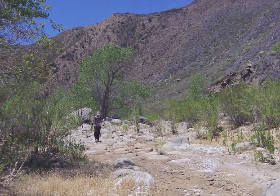
| Trail description: | Hiked up the mono-alamar trail as part of a trip to big pine mountain. If it were not for the frequent tape I would never have made it. After the nice dirt road going by little caliente spring ended in a gate, the trail became totally overgrown and difficult to follow. It crossed the creek twice after this before reaching the mono-alamar trail register. After this, it crossed the creek countless times and at times vanished on its way up to Ogilvy ranch. Some sections were better than others. Near the ranch, it joined another nice clear dirt road for a while before it got to a sign near entrance to the ranch where it left the road again. To save time, I hiked through the ranch and along the airstrip instead of hiking this section. After this, I followed an overgrown road until I met up with the proper trail again. The trail then winds its way up the creek crossing it many times and becoming extremely hard to follow (search for tape was essential). Eventually it makes its way up to a point where it climbs above the creek and reaches the mono narrows where mono creek branches off and the trail follows another creek up the canyon. I got very confused here because the trail leading across the creek was blocked off by brush. Nevertheless I found it eventually and went up the section known as the caracole where the trail switchbacks up the steep side of the canyon. After this, the trail became very overgrown with some downed trees in the trail and lots of bushwhacking was required, tape search was very important in this section as well. Eventually the trail got a little more open just before reaching the junction with the alamar and poplar trails. |
| Mode of transport: | Hike |
| Trail condition: | Hard to follow |
| Images: | Every time the trail crosses the creek, it's another tape search. It sure was odd to see Ogilvy ranch with a plane and houses all the way out here. The trail is very overgrown with lots of vegetation growing in tread. This is the part known as the caracole, after these relatively open switchbacks the trail got extremely overgrown and hard to follow. Lots of downed trees and overgrowth closing in the trail. |
Mono-Alamar Trail Survey - 02-29-2016 - by Los Padres Forest Association| Link: | Mono-Alamar Trail |
| Date: | 02-29-2016 |
| Surveyor Name: | Los Padres Forest Association |
| Trail description: | LPFA scouted and flagged the Mono Alamar Trail from Mono Narrows up to the Poplar/Alamar Trail junction at the bottom of Loma Pelona. Â The Mono-Alamar Trail is in great shape from the trailhead at Romero Camuesa up to the Narrows but the final few miles up the Caracole are in bad shape. Â Expect serious bushwhacking, some crawling and a lot of stopping and looking for signs of the trail. Â We flagged the trail extensively in advance of a CCC trail crew working this section in spring 2016. Â There was water at Mono Narrows but no other water up the canyon. |
| Mode of transport: | Hike |
| Trail condition: | Hard to follow |
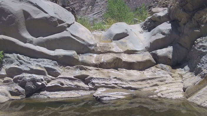
| Images: | View down from the Caracole into Mono Narrows Expect a lot of this as you head up the Caracole. The tread is there but you're bushwhacking and unable to see your feet And expect this as well: downed trees and brush over the trail everywhere There is an old camp about 3/4 of the way up from the Narrows called Caracole Camp Signage at the junction of Mono-Alamar Trail, Poplar Trail and Alamar Trail |
Mono-Alamar Trail Survey - 11-10-2015 - by Los Padres Forest Association| Link: | Mono-Alamar Trail |
| Date: | 11-10-2015 |
| Surveyor Name: | Los Padres Forest Association |
| Trail description: | LPFA in conjunction with the Forest Service hired a California Conservation Corp (CCC) crew to work the Mono-Alamar Trail from the up-canyon side of Ogilvy Ranch up to Mono Narrows. Â They completed work up to the old Upper Mono Campground, which is about 200 yards short of the Narrows. Â FANTASTIC work to say the least. Â Check out more information here: https://www.facebook.com/LosPadresForestAssociation/posts/466617746796488 |
| Mode of transport: | Array |
| Trail condition: | Needs some work |
Mono-Alamar Trail Survey - 07-06-2014 - by Los Padres Forest Association| Link: | Mono-Alamar Trail |
| Date: | 07-06-2014 |
| Surveyor Name: | Los Padres Forest Association |
| Trail description: | The trail is hit or miss up the canyon as expected. Â There was no water until about a mile below the Mono Narrows. Â Even then it was a stagnant pool. Â DRY OUT THERE. |
| Mode of transport: | Bicycle |
| Trail condition: | Needs some work |
| People Seen: | 0 |
| Images: | |
 Survey / Report Form - Please click this box to open the form.