 Use Marker Groups
 Wolf 2002
Piru 2003
Day 2006
Zaca 2007
Gap 2008
La Brea 2009

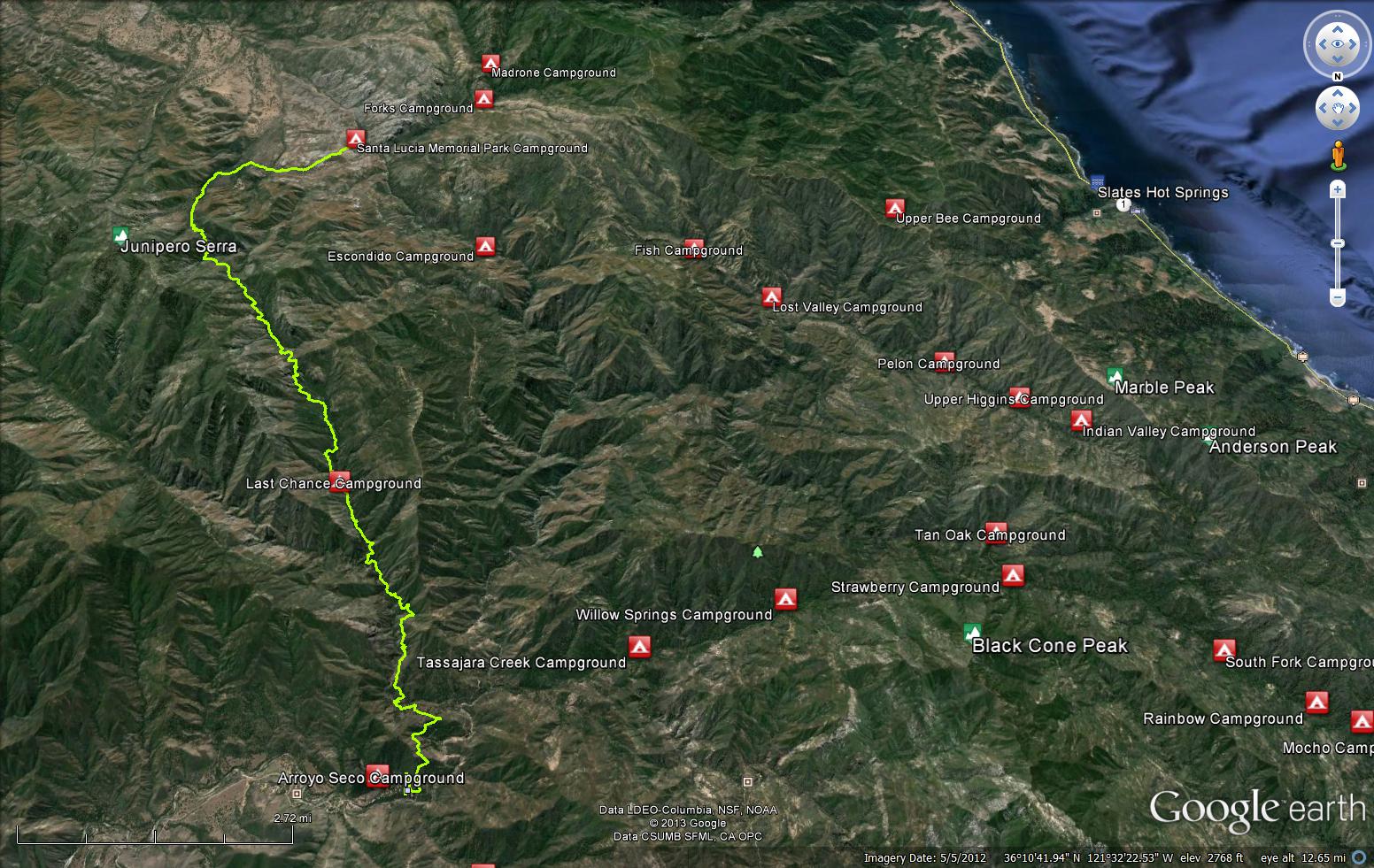
The Santa Lucia River Trail starts at Santa Lucia Memorial Park Campground and climbs towards the junction of the Santa Lucia Peak Trail before the long hike down towards Arroyo Seco. The trail is most commonly used by hikers headed to Santa Lucia Peak and is within the Ventana Wilderness.


 Santa Lucia Creek Trail Survey - 08-06-2023 - by Anonymous Surveyor
| Link: | Santa Lucia Creek Trail |
| Date: | 08-06-2023 |
| Surveyor Name: | Anonymous Surveyor |
| Trail description: | Update on my 2022 survey. This time came from the Memorial Campground side. The first 700 m of the trail are easily passable. At the Roosevelt Creek the crossing is totally overgrown, there are some signatures of previous attempts to cut through that failed. I did had much time to clear this time. However, looking at the trail from the side slope it seems that after Roosevelt Creek it should be mostly fine all the way to watershed (36.1507342,-121.4443153). That adds another 1.1 km of trail that is potentially easy. The watershed switches us from southern slope to northern slope and (check satellite images!) the chaparral gets much much worse. This is the slope where we get stuck in 2022. However, the watershed point is just 700 m away from the point where we turned back in 2022 (trail distance, not straight distance!). So the trail can be cut through with a team of several men. |
| Mode of transport: | Hike |
| Trail condition: | Non existent |
| Condition details: | impassable section is less than a kilometer! |
Santa Lucia Creek Trail Survey - 02-21-2022 - by Anonymous Surveyor| Link: | Santa Lucia Creek Trail |
| Date: | 02-21-2022 |
| Surveyor Name: | Anonymous Surveyor |
| Trail description: | From Arroyo Seco to the saddleback that is the Santa Lucia creek watershed (36.1658109, -121.4588115) the trail is passable. At some points it is hard to follow, but some small cairns mark the way. On the segments that go on the river, of course, there is no trail. As of February 2022 I have cut all branches that were across the trail and most of the way to the saddle you can go with a backpack without a need to crawl. After the saddle (36.1658109, -121.4588115) the burned area ends and the trail is overgrown with thick chaparral. We were able to slowly wade through with help of saw. The direction can be traced through easily as there is a bulldozer cut on the hillside. It is seen on satellite image and creates a fake impression of existing trail. At (36.1620649, -121.4544111) the cut merges into the riverbed and then there is a short stretch that can be normally hiked. This stretch ends at (36.1588252, -121.4515894), where the trail goes left from the river. Once the trail climbs back on the hillside, its condition becomes miserable. We spent about 2 hours to progress 700 meters of the trail. To check if we are still on it I need to go down on my knees and look forward under chaparral. As we were running out of daylight and out of saw battery we came to point (36.1552303, -121.4488428) where I could no longer recognize any sign of ever existing trail on the ground at all. So basically from that point cutting can be done in any direction. We turned back at this point. On the OpenStreetMap I have disabled part of the trail from this point to the Juniperra Serra spur. |
| Mode of transport: | Hike |
| Trail condition: | Non existent |
| Condition details: | totally overgrown between Junipera Serra spur and Santa Lucia creek watershed |
| Images: | Condition of the trail right after the saddleback. Find a boy on the image! There we did little cutting, just were pushing through. |
Santa Lucia Creek Trail Survey - 02-25-2018 - by RobStone| Link: | Santa Lucia Creek Trail |
| Date: | 02-25-2018 |
| Surveyor Name: | RobStone |
| Trail description: | A friend and I attempted to hike from Memorial Park Campground to Last Chance Falls/Camp and ultimately bailed. The trail was clear up to the St Lucia Peak spur trail, from then on the Santa Lucia Trail becomes a nightmare of thick brush, downed trees, and many deadfalls. The trail is faintly visible, we had to stop to route find many times and got properly thrashed by the sharp brush. It took us about 3 hours to go 2 miles to the next ridgeline. At that rate, there was no way we'd make it to Last Chance before dark so we bivvied on the first ridge at a small clearing just big enough for a tent (seemed like we weren't the first people to do so at this spot). We bailed the next day and tried to clear as much dead limbs as we could but the trail needs some major work before another attempt. I'm hardy enough to push through a proper bushwhack but this trip was very tough. I'm not sure if the trail opens up after that first ridge but if it's anything like the first 2 miles then I would not recommend a through trip attempt without a machete, loppers and proper bushwhack attire. Good Luck. |
| Mode of transport: | Hike |
| Trail condition: | Hard to follow |
| Condition details: | Memorial Park Campground to Last Chance Camp (Bailed/Impassable in current conditions) |
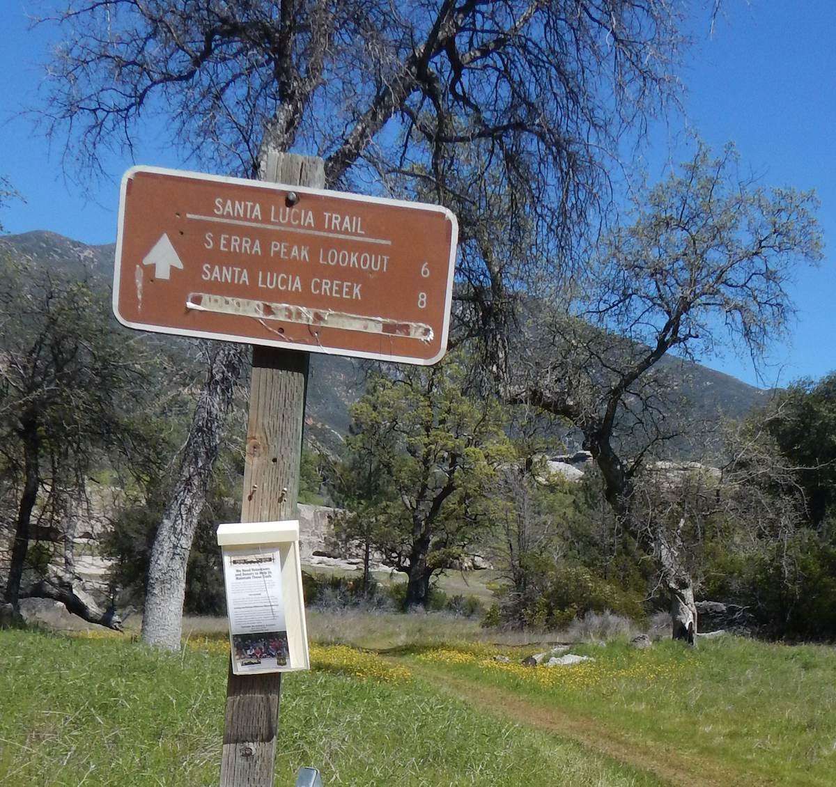
| Images: | Trail split at St Lucia Peak, note the etchings on the sign. A relatively decent section. Route is very hard to follow, but possible. On the way out. Beautiful but painful. |
Santa Lucia Creek Trail Survey - 03-30-2017 - by Los Padres Forest Association| Link: | Santa Lucia Creek Trail |
| Date: | 03-30-2017 |
| Surveyor Name: | Los Padres Forest Association |
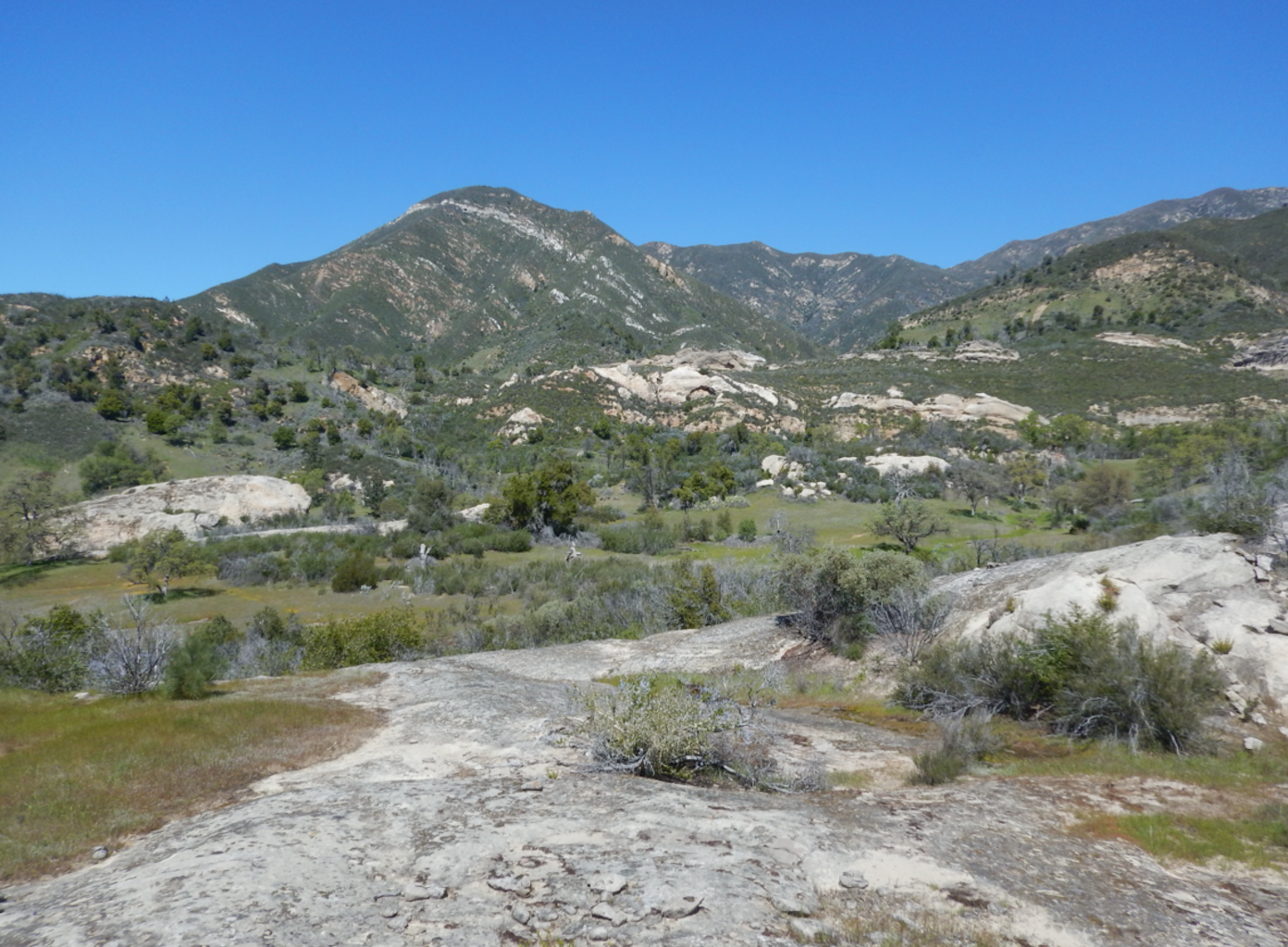
| Trail description: | Hiked the first few miles of this spectacular trail. Lots of flowers, rocks to explore and water EVERYWHERE! Wish I had more time to continue on towards the peak. Next time...... |
| Mode of transport: | Hike |
| Trail condition: | Good shape and easy to follow |
| Images: | |
 Survey / Report Form - Please click this box to open the form.