 Use Marker Groups
 Wolf 2002
Piru 2003
Day 2006
Zaca 2007
Gap 2008
La Brea 2009

| Date | Surveyor | Water Report |
| 02-23-2022 | Anonymous Surveyor | Dry |
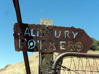
This camp is located off the Bull Ridge Trail on top of a small hill looking over the rustic cabin on Salisbury Potrero. To access the camp, start from the Sierra Madre Road 32S12.2. Then drop down the Bull Ridge Trail to Salisbubry Potrero, pass the cabin on your right, climb the first hill and once your reach the top, the camp is about 100 yards to the right along the ridge. Look for a small fire ring, the camp has no access to water and no table either, just an old fire ring on top of the hill
Directions from Taft, CA: Travel 8 miles south on Highway 33. Continue south for 13 miles after Highway 33 joins Highway 166. Stay on Highway 166 until it reaches New Cuyama and turn south onto Perkins Road. Drive on this road until it ends at a locked gate. From here hike on trail #26W01 for about 5 miles to the campsite.
 Salisbury Potrero Camp Survey - 02-23-2022 - by Anonymous Surveyor
| Link: | Salisbury Potrero Camp |
| Date: | 02-23-2022 |
| Surveyor Name: | Anonymous Surveyor |
| Camp Description: | |
| Water Source: | Dry |
| Water Source Details: | Hiking from South Fork to Sweetwater to Salisbury there is no water. Trail needs some brushing but no problems navigating. |
| Weather Conditions: |
 Survey / Report Form