 Use Marker Groups
 Wolf 2002
Piru 2003
Day 2006
Zaca 2007
Gap 2008
La Brea 2009

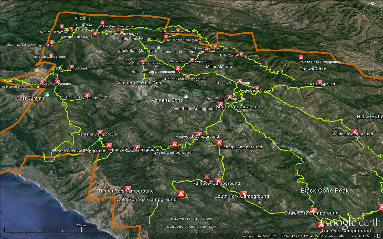
The Pine Ridge Trail is a true classic of the Big Sur region and one of the most iconic trails in the Los Padres National Forest. The PRT, as it is sometimes called, connects Big Sur Station off Hwy 1 with China Camp along Tassajara Road. There are too many highlights to mention along the PRT and quite a few excellent campgrounds to check out along the way.
* Note that parking can be complicated and competitive at Big Sur Station and does cost $10/night to park within the State Parks parking lot.

.jpg)


 Pine Ridge Trail Survey - 03-07-2024 - by Anonymous Surveyor
| Link: | Pine Ridge Trail |
| Date: | 03-07-2024 |
| Surveyor Name: | Anonymous Surveyor |
| Trail description: | Trail Alert, March 4, 2024: The section of the Pine Ridge Trail between Barlow Flat Camp and Sykes Camp is IMPASSABLE due to a new slide. The only access to Sykes Camp is via a reroute through Barlow Flat Camp. However, that route requires a crossing of the Big Sur River which may be life threatening during times of rain. Visitors planning to visit the Pine Ridge Ridge Trail and Sykes Camp SHOULD NOT attempt to cross the new slide. Doing so could be fatal and/or put Monterey County Search and Rescue personnel at risk if a rescue/extraction is required. Visitors taking the reroute through Barlow Flat Camp SHOULD NOT attempt to cross the Big Sur River (or any Wilderness stream) during high water. If a visitor falls in the water, even a light current may sweep them downstream where they risk drowning or impact with rocks. There is no estimated date of repair to the damaged section of trail. |
| Mode of transport: | Hike |
| Trail condition: | Non existent |
Pine Ridge Trail Survey - 07-07-2023 - by Thomas V. Dollente| Link: | Pine Ridge Trail |
| Date: | 07-07-2023 |
| Surveyor Name: | Thomas V. Dollente |
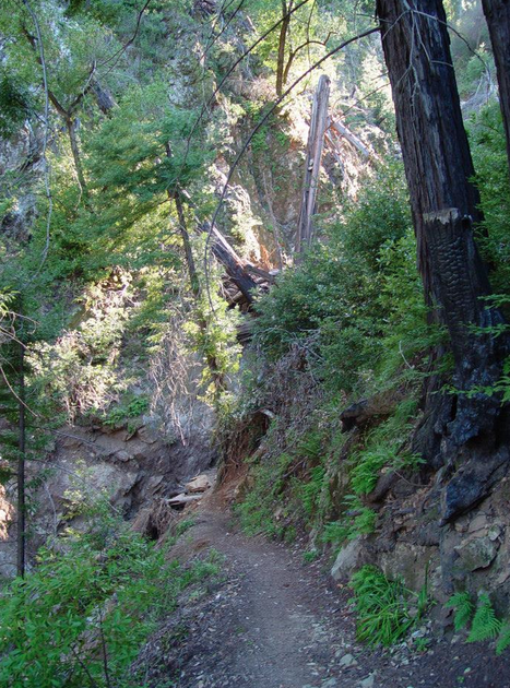
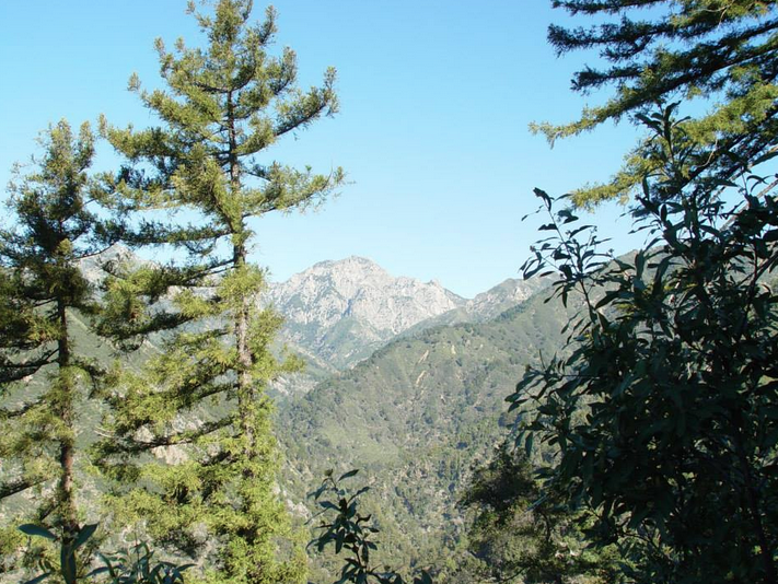
| Trail description: | Did the entire trail out-and-back over 3 days. The trail is in good condition, even in the eastern portion. Thanks to trail crews on getting this back into shape after the aggressive winter! Water available in most spots where they might normally be dry midsummer, this being 2023. Good flow at Pine Ridge Camp spring, trickle at Divide Camp, but good flow at the gully just uphill from Divide Camp. At the very top of Carmel River, I got water, just about 10 minutes hike down from Church Creek Divide. |
| Mode of transport: | Hike |
| Trail condition: | Good shape and easy to follow |
| Images: | From the trail between China Camp and Church Creek Divide Rock fall uphill from Divide Camp. Note that the pathway is cleared/leveled The Big Sur River at Barlow Flat Big Sur Canyon looking out to sea |
Pine Ridge Trail Survey - 01-25-2023 - by Gary Felsman| Link: | Pine Ridge Trail |
| Date: | 01-25-2023 |
| Surveyor Name: | Gary Felsman |
| Trail description: | *** VWA/USFS Volunteer Ranger/Trail Crew Report *** Description: VWA/USFS Volunteer Rangers, USFS Forest Service and other agencies continue to patrol the Monterey Ranger District Road and Trails Systems for damage after the recent storms. The below report indicates the Pine Ridge Trail is impassable. Here are a couple of pictures of the impassable section, which is being evaluated for safety and a possible solution to the problem. Be patient and plan accordingly as sections of the LPNF open up to the general public again. The goal here is to keep the public informed of potential hazards. If you want to help with potential projects with the VWA/USFS be sure to sign up with their Meet Up Group to be notified of future outings. |
| Mode of transport: | Hike |
| Trail condition: | Needs some work |
| Condition details: | Pine Ridge Trail washout shortly past Ventana Camp Jct. |
| Images: | Approximate Location of Washout. Collasped Section of Trail Another view of collapsed trail. |
Pine Ridge Trail Survey - 02-22-2022 - by Anonymous Surveyor| Link: | Pine Ridge Trail |
| Date: | 02-22-2022 |
| Surveyor Name: | Anonymous Surveyor |
| Trail description: | Trail reopened in spring 2021 |
| Mode of transport: | Array |
| Trail condition: | Good shape and easy to follow |
Pine Ridge Trail Survey - 08-10-2019 - by Lucioperca| Link: | Pine Ridge Trail |
| Date: | 08-10-2019 |
| Surveyor Name: | Lucioperca |
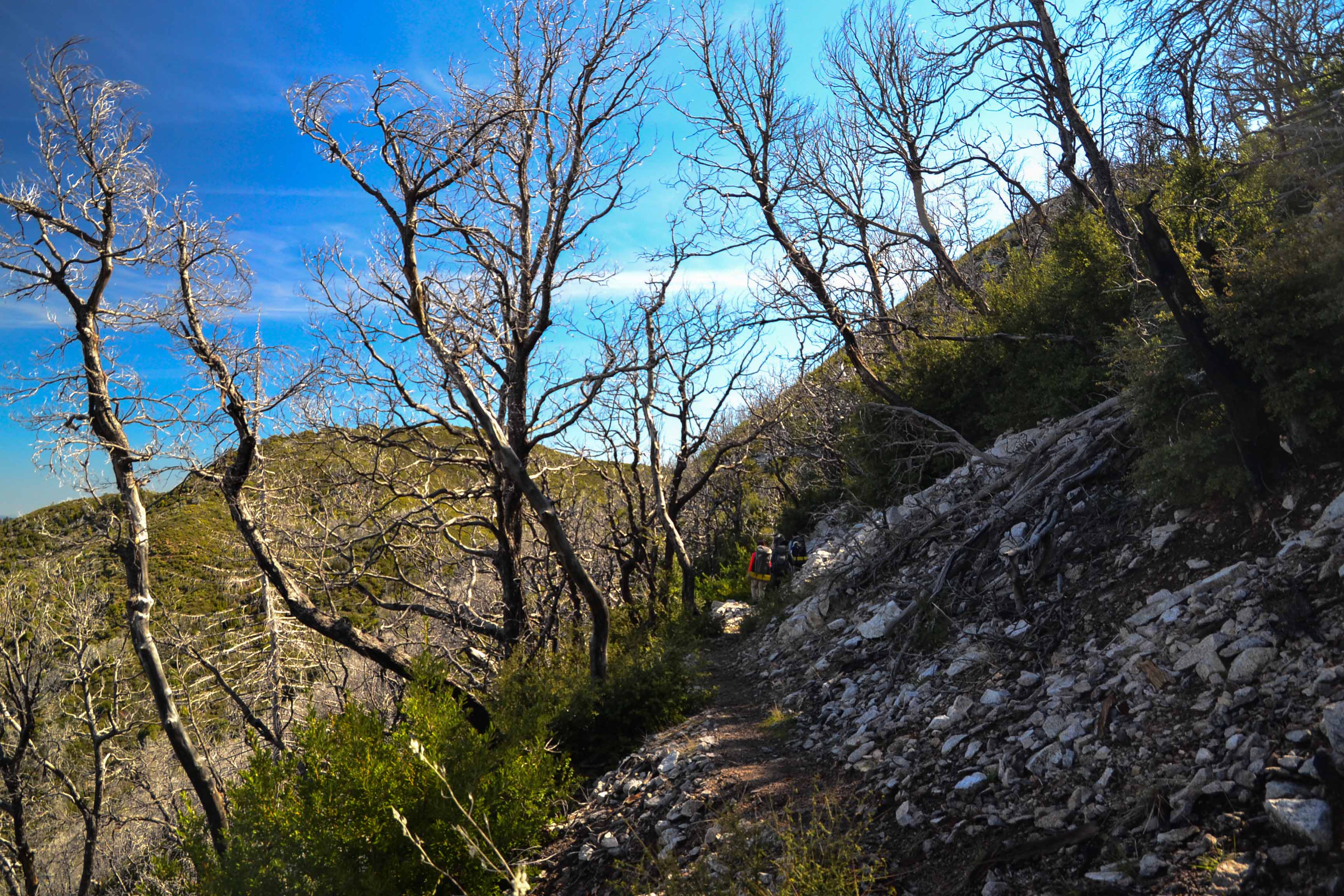
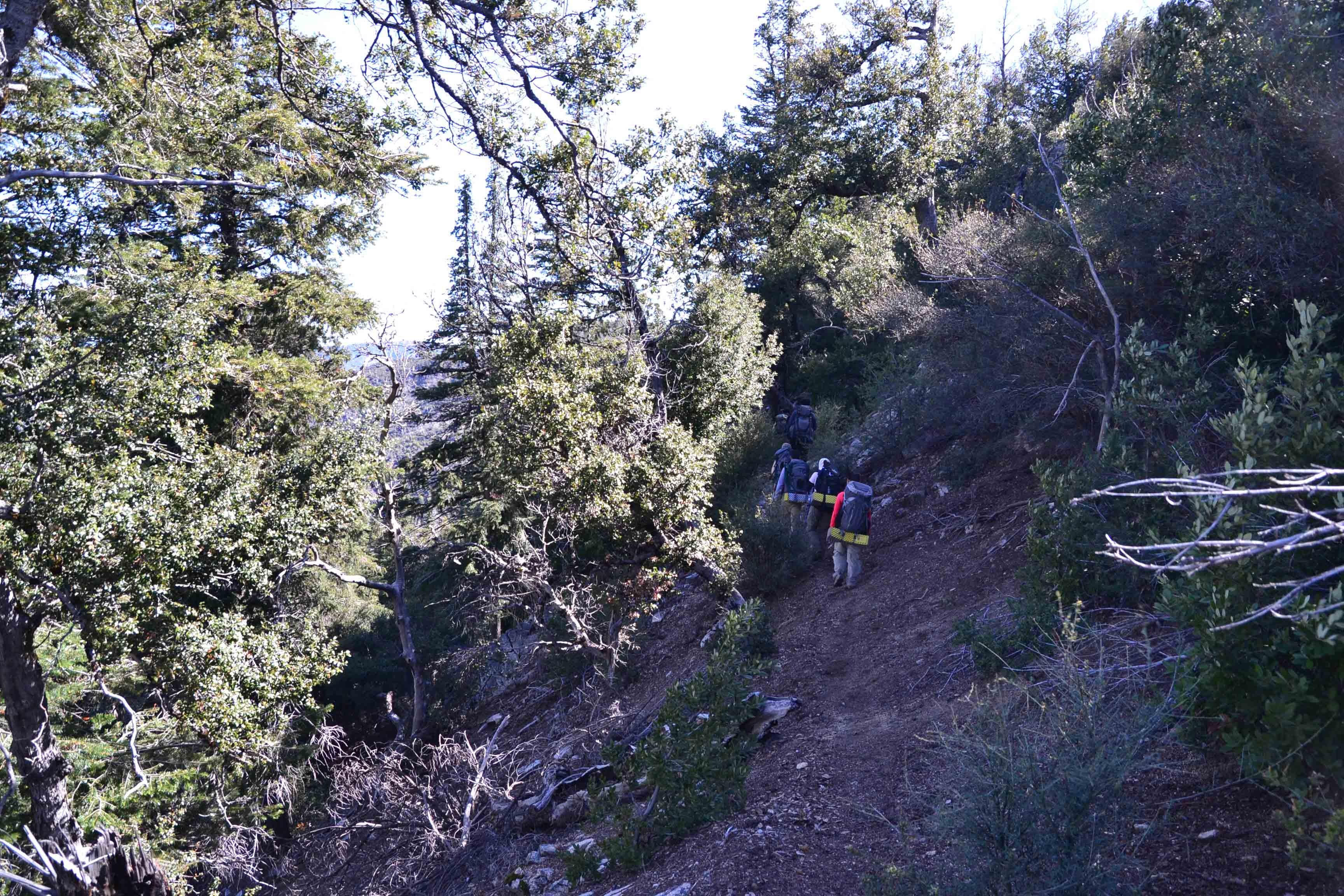
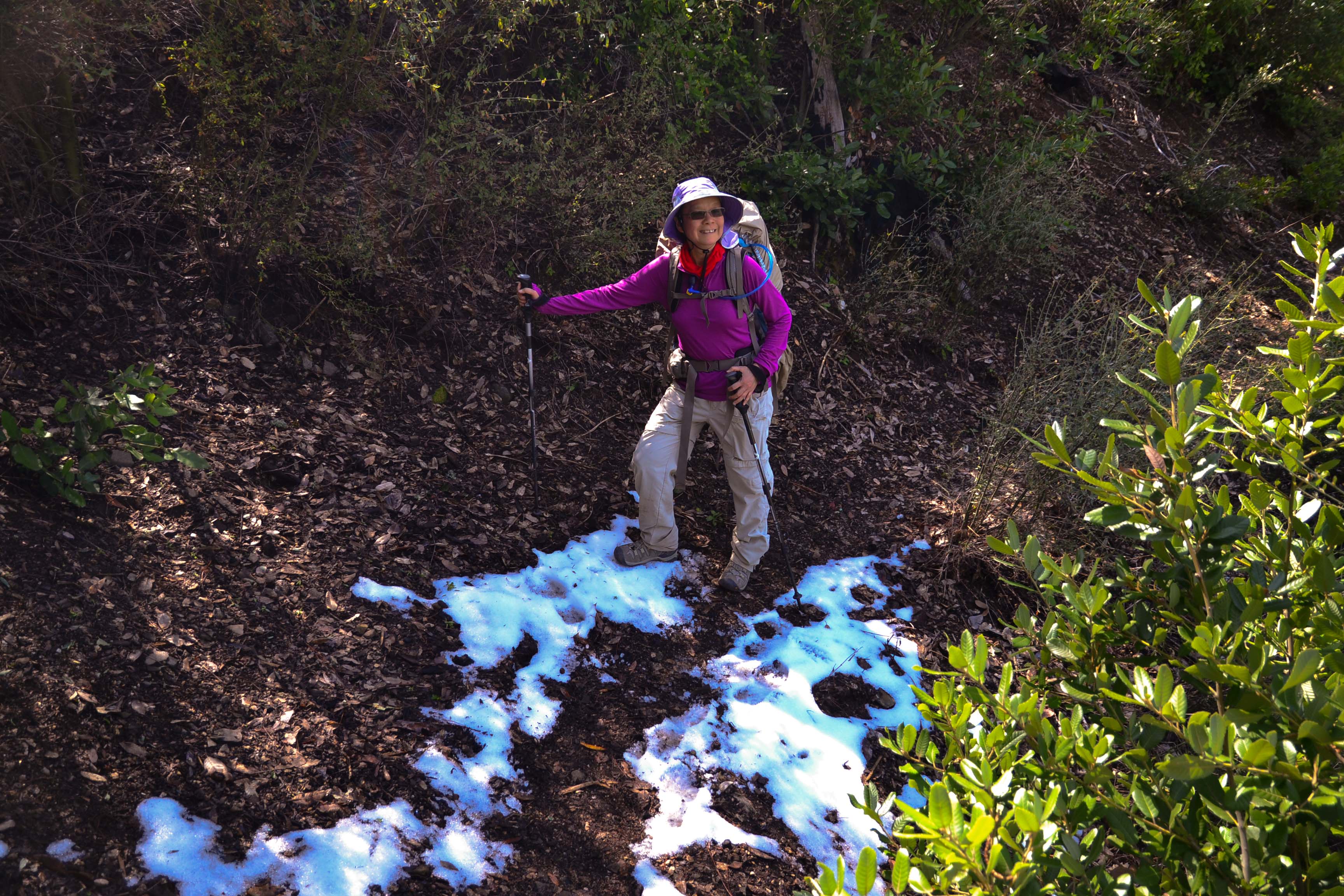
| Trail description: | Tassajara Road: Recently graded, able to navigate in our
minivan, going slowly. Would not attempt if it had not been recently
graded. China Camp to Church Creek Divide: Good
shape & easy to follow. Clearly well maintained and well
used. Church Creek Divide to Divide Camp: Clearly less
well used and maintained. A few trees across the trail, and one spot where the
trail is about to be completely lost due to a small
landslide. Divide Camp to unnamed creek: Even less well
used and maintained. Several more trees across the trail and thick, overgrown
brush. Our small group parked at the China Camp
trailhead and hiked in for a quick one-night overnight at Divide
Camp. The hike in was lovely: warm but overcast
so not too hot. The hike out was grueling: no cloud cover, and very hot. Still,
it was beautiful. As others noted, there's no
water from China Camp to past the Church Creek Divide, so plan
accordingly. |
| Mode of transport: | Hike |
| Trail condition: | Needs some work |
| Condition details: | China Camp to Divide Camp (and just a little beyond) |
| Images: | Trailhead signage with closure and fire notices Along the trail, between China Camp and Church Creek Divide Along the trail, between China Camp and Church Creek Divide Church Creek Divide Downed log helps cross a draw between Church Creek Divide and Divide Camp |
Pine Ridge Trail Survey - 05-31-2016 - by Anonymous Surveyor| Link: | Pine Ridge Trail |
| Date: | 05-31-2016 |
| Surveyor Name: | Anonymous Surveyor |
| Trail description: | Hiked an out and back from China Camp to Redwood Camp over memorial day weekend. Would not recommend this route (either hike in from Big Sur Station, or do a through-hike with shuttle from China Camp). As others have mentioned, the trail was mostly clear and well maintained from China Camp to Divide Camp. Between Divide Camp and Pine Ridge Camp there is significant overgrowth - the trail is visible at your feet, but you must bushwhack through (mostly) california lilac and (some) prickly plants and poison oak to get through. From Pine Ridge to Redwoods, the foliage changes, but you are still pushing your way through (mostly) prickly bushes and (some) poison oak. Doable, but would recommend long pants and possibly long sleeves (or be ok getting scratched-up/with poison oak exposure). Water was flowing at Divide Camp (stream crosses the trail shortly after the turnoff for camp), Pine Ridge Camp (stream is beyond the main camp area - follow the path beyond the fire pit), and Redwoods. Also one additional water spot between Divide Camp and Bear Creek Connector trail. If you are considering doing this hike soon, be aware, its biting fly season - they're vicious and plentiful. There is a constant buzzing din from about 9:30am - 6:00pm, any rest stops result in swarms of 20+ flies, and if you hit camp early, you may find yourself hiding in your tent until dusk. They did not respond to DEET. I would not hike again in these conditions, but if you're braving it - wear loose-ish long-sleeves and long pants (they bit right through my running leggings) and consider bringing a bug net for your head. |
| Mode of transport: | Hike |
| Trail condition: | Needs some work |
| Condition details: | Overgrown |
Pine Ridge Trail Survey - 05-16-2016 - by Kali| Link: | Pine Ridge Trail |
| Date: | 05-16-2016 |
| Surveyor Name: | Kali |
| Trail description: | We hiked the entirety of the trail from China Camp down to Big Sur Station, camping at Redwood Camp and Ventana Camp along the way. The trail was easy to follow, but large sections of the trail between China Camp and Sykes were extremely overgrown. We had to push our way through thick brush through a majority of this section, though never lost the trail. We picked up some ticks along the way, so hikers in this section should exercise caution in that respect. Campgrounds and trail junctions were well marked and there were ample opportunities for restocking on water along the way. The section between China Camp and Sykes offered plenty of peace and solitude, with barely any other hikers and campers along the way. |
| Mode of transport: | Hike |
| Trail condition: | Needs some work |
| Condition details: | China Camp to Big Sur Station |
Pine Ridge Trail Survey - 11-28-2015 - by Chester| Link: | Pine Ridge Trail |
| Date: | 11-28-2015 |
| Surveyor Name: | Chester |
| Trail description: | Heavily travelled trail in good condition# We did a two night trip camping at terrace creek and hiking to the Sykes hot springs on day two#
All three pools were full of water but there were a lot of people## you won’t find solitude on this trail, however there are great views and a lush environment# I think the "very-strenuous" difficulty is overstated, it was a relatively easy trail all the way to the hot springs with only a few strenuous sections#
|
| Mode of transport: | Hike |
| Trail condition: | Good shape and easy to follow |
| Images: | |
Pine Ridge Trail Survey - 01-30-2015 - by Los Padres Forest Association| Link: | Pine Ridge Trail |
| Date: | 01-30-2015 |
| Surveyor Name: | Los Padres Forest Association |
| Trail description: | The Pine Ridge Trail was reopened January 30, 2015. There remains a serious washout about 2miles up the trail from Big Sur Station. Â Please be careful when hiking the trail and if you are uncomfortable, turn around and live to hike another day. Â Sykes can still be accessed from the Terrace Creek Trail which bypasses the dangerous slide. Check here for more photos of the slide: https://www.facebook.com/media/set/?set=a.884817044873450.1073741827.884800874875067&type=1 ------- THE WESTERN PINE RIDGE TRAIL IS CLOSED AT THE MOMENT DUE TO LANDSLIDES AND UNSAFE TRAIL CONDITIONS. Â ACCESS TO SYKES CAN BE ALONG THE TERRACE CREEK TRAIL OR THE EASTERN PINE RIDGE TRAIL. |
| Mode of transport: | Array |
| Trail condition: | Needs some work |
| Images: | Slide section ahead showing trail - slide - trail, photo Tim Bills |
Pine Ridge Trail Survey - 12-29-2014 - by Los Padres Forest Association| Link: | Pine Ridge Trail |
| Date: | 12-29-2014 |
| Surveyor Name: | Los Padres Forest Association |
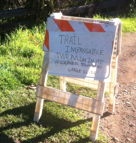
| Trail description: | The Pine Ridge Trail is closed at the moment due to landslides and damaged trails. Â There is no date set for when it might reopen. Â Most likely not until Summer 2015. The parking lot is closed as well. |
| Mode of transport: | Array |
| Trail condition: | Hard to follow |
| Images: | Sign as seen at the Pine Ridge Trail parking lot. |
Pine Ridge Trail Survey - 04-05-2014 - by Anonymous Surveyor| Link: | Pine Ridge Trail |
| Date: | 04-05-2014 |
| Surveyor Name: | Anonymous Surveyor |
| Trail description: | Someone installed new signs on some of the junctions. The trail is passable, but very overgrown. There were down trees, but nothing significant. Not much poison oak either, at least up to the Pine RIdge camp. The overgrowth is with some other bushes. Be prepared for ticks that can perhaps be active in more warmer weather. |
| Mode of transport: | Hike |
| Trail condition: | Needs some work |
| Condition details: | Overgrown, but still passble |
| People Seen: | 2 |
| Images: | |
 Survey / Report Form - Please click this box to open the form.