 Use Marker Groups
 Wolf 2002
Piru 2003
Day 2006
Zaca 2007
Gap 2008
La Brea 2009

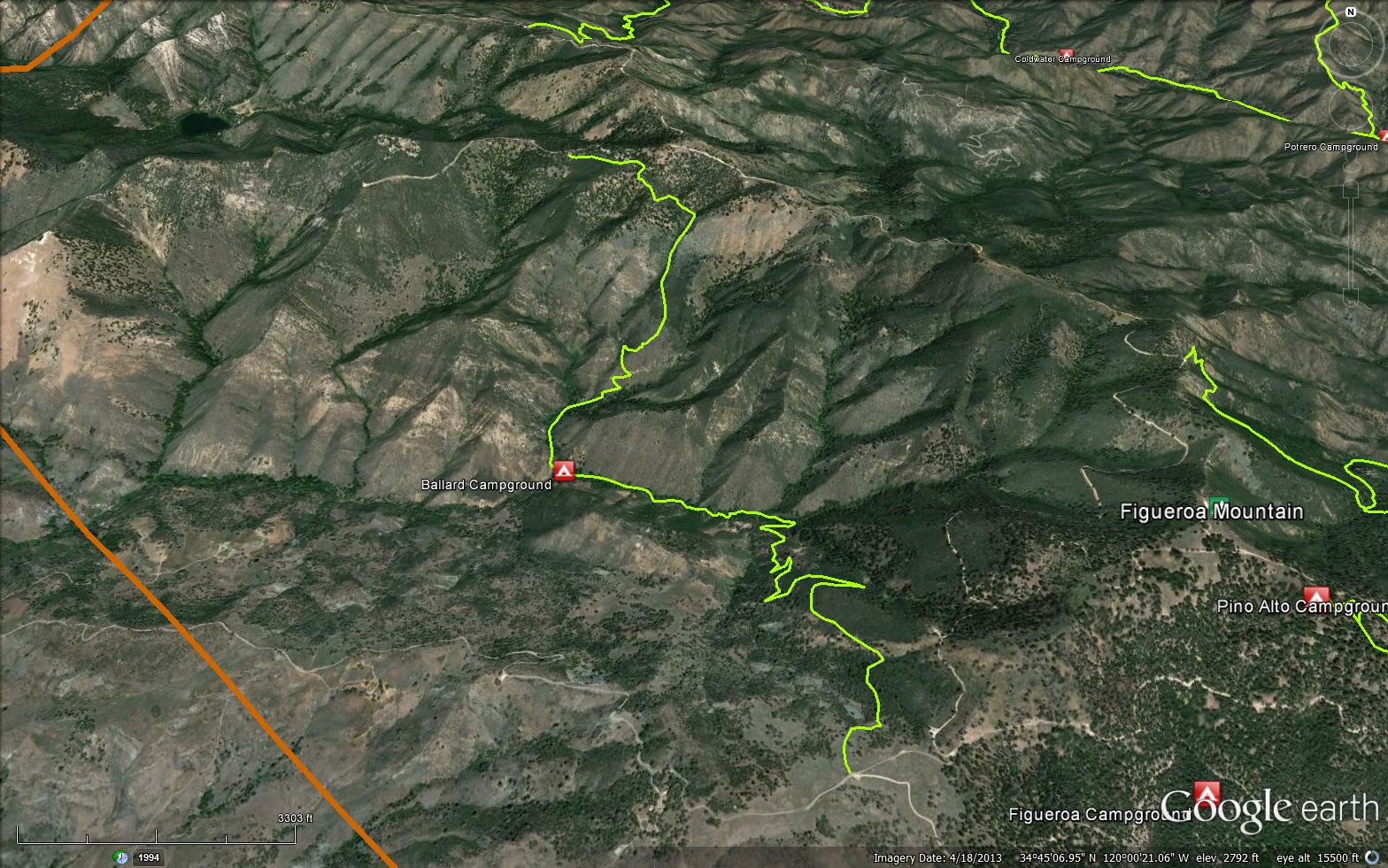
The trail runs from Sawmill basin on Figueroa Mountain Road, pass Ballard Camp in Birabant Canyon, then up the mountain side to La Jolla Spring and on up to the east side of Lava Peak and up to Zaca Peak Trail (30W18).


 La Jolla Trail Survey - 03-17-2023 - by Amy Findlay
| Link: | La Jolla Trail |
| Date: | 03-17-2023 |
| Surveyor Name: | Amy Findlay |
| Trail description: | There were quite a few downed trees across the trail path. We were able to hike around them to the creek crossing and even move a few off the trail. Many were Manzanita. |
| Mode of transport: | Hike |
| Trail condition: | Needs some work |
| Condition details: | Downed trees and shrubs across the trail in many places |
| Images: | Within first half mile. Manzanita across trail Large manzanita across trail I believe a Lemonade berry across trail |
La Jolla Trail Survey - 10-31-2021 - by Luna| Link: | La Jolla Trail |
| Date: | 10-31-2021 |
| Surveyor Name: | Luna |
| Trail description: | From the creek up to zaca ridge road was a true adventure. First the poison oak, which was unavoidable. Some false hope once you get out of the creek and start upwards through a beautiful oak woodland with the biggest oaks you've ever seen. Then the adventure really starts. At first you're on a deer trail through sharp yucca and sage, and eventually calling it even a deer trail is a compliment. Straight up, getting stabbed by yucca for 2 hours we covered 0.2 miles. Eventually the sage yields to mahogany and ceanothus, and you are literally on hands and knees on what must be a raccoon trail, not even deer could get through. At the ridge high point, you could be tempted to go down to the meadow, but it really does get better from here. Follow the ridge straight up, don't trust the trail on Google maps; NatGeo map is spot on. Back on what is an animal trail, it feels like a 3 Lane freeway and you'll be flying along at 1 mph, which will feel so fast. Take the road back. Better yet, take the road there and back and skip the trail, it needs serious work and we were starting to wonder when to call search and rescue. Pulled 56 ticks off of the dog; only the most rugged and well behaved dogs should even think attempting this, but really don't subject one to this struggle. |
| Mode of transport: | Hike |
| Trail condition: | Non existent |
| Condition details: | Take the road instead |
La Jolla Trail Survey - 07-17-2021 - by Stan Atchison| Link: | La Jolla Trail |
| Date: | 07-17-2021 |
| Surveyor Name: | Stan Atchison |
| Trail description: | Trail is in very good condition from the trailhead down to Upper Ballard camp. The next segment to Ballard camp was identifiable but needs some work. I am interested in finding the thru trail up to Zaca Peak. I will be returning to continue soon. Water is trickling until about a quarter mile past Upper Ballard. Hot hike out on the exposed switch backs. |
| Mode of transport: | Hike |
| Trail condition: | Needs some work |
La Jolla Trail Survey - 06-07-2021 - by Anonymous Surveyor| Link: | La Jolla Trail |
| Date: | 06-07-2021 |
| Surveyor Name: | Anonymous Surveyor |
| Trail description: | Trail is in good condition but we were forced to turn back to the road about 1/2 mile from Ballard camp due to a pretty active beehive on the trail |
| Mode of transport: | Hike |
| Trail condition: | Needs some work |
La Jolla Trail Survey - 03-21-2021 - by Anonymous Surveyor| Link: | La Jolla Trail |
| Date: | 03-21-2021 |
| Surveyor Name: | Anonymous Surveyor |
| Trail description: | Trail was in great shape from the road to the camp sites. Looks like the crew had been there relatively recently, as many trees were cleared and appeared recently cut. Water was flowing strong. Beyond the campsites, the trail becomes overgrown. We stopped about a .5 after the campsites, as it got overgrown and narrow along the creek. |
| Mode of transport: | Hike |
| Trail condition: | Good shape and easy to follow |
La Jolla Trail Survey - 08-11-2019 - by Gerry Ching| Link: | La Jolla Trail |
| Date: | 08-11-2019 |
| Surveyor Name: | Gerry Ching |
| Trail description: | This describes a hike from the Figueroa Mtn Rd trailhead to Upper Ballard Camp (1.65 mile one way). I've broken the hike into three sections of 0.55 mile. The first segment is in good shape with the tread clear and no obstructions. The 2nd segment is badly overgrown in a number of spots, but the tread is easy to find. There are two downed trees across the trail, one with a path around the tree. The 3rd segment is generally in good shape, but does have a few overgrown spots. There is also a tree across the trail but a path around the obstruction exists. Note that this section is where most of the elevation loss occurs and is the steepest section. Upper Ballard Camp is in fair shape, but there is lots of weeds with stickers that really stick to socks and shoe laces. Gaiters are highly recommended if you spend any time in the camp. |
| Mode of transport: | Hike |
| Trail condition: | Needs some work |
| Condition details: | Dayhike to Upper Ballard Camp |
La Jolla Trail Survey - 05-10-2018 - by Los Padres Forest Assocation| Link: | La Jolla Trail |
| Date: | 05-10-2018 |
| Surveyor Name: | Los Padres Forest Assocation |
| Trail description: | Trail requires route finding. There are sections that are passable and others where crawling through brush is required. Look for blazes that indicate original route. Read more here: "The trail is overgrown with regrowth from the fire and much of the old tread is covered with loose ravel that has slid down since the fire."-  Songs of the Wilderness trail Blog and La Jolla Trail to Manzana Creek |
| Mode of transport: | Hike |
| Trail condition: | Hard to follow |
La Jolla Trail Survey - 08-17-2018 - by Wim van Dam| Link: | La Jolla Trail |
| Date: | 08-17-2018 |
| Surveyor Name: | Wim van Dam |
| Trail description: | I wanted to photograph dragonflies along the creek so I hiked from Figueroa Mountain Road down to the canyon and back up again on this hot day between 09:40 and 13:20. The trail from Figueroa Mountain Road to the canyon is in good shape. The stretch from Upper Ballard Campground to Ballard had some spots where I had to scramble to get through; one fresh fallen tree is a bit annoying. Alamo Pintado Creek is flowing slowly but surely. There were loads of flies and nasty plants, so I'd recommend long sleeves and long trousers. I didn't encounter anybody during the hike but there was one old tent at Upper Ballard Campground. I made a U-turn before I reached Ballard, so I can't write anything about that. In all, this was a 4.2 mile round trip, from 3,350' to 2,220' and back again. The hike down to Upper Ballard Campground took less than an hour; the hike up again from this camp took about one-and-a-half hour. I needed about 800ml of water. This trail is probably much more enjoyable in spring (less hot, more flowers and wildlife, more water, et cetera) .  |
| Mode of transport: | Hike |
| Trail condition: | Needs some work |
La Jolla Trail Survey - 03-17-2018 - by Nate| Link: | La Jolla Trail |
| Date: | 03-17-2018 |
| Surveyor Name: | Nate |
| Trail description: | The trail was well maintained and Ballard camp was in good condition. However, the trail after Ballard camp was in poor condition and required a lot of bushwhacking through poison oak. The Alamo Pintado Creek had plenty of water. |
| Mode of transport: | Hike |
| Trail condition: | Needs some work |
La Jolla Trail Survey - 12-15-2017 - by M. Jones| Link: | La Jolla Trail |
| Date: | 12-15-2017 |
| Surveyor Name: | M. Jones |
| Trail description: | Trail is great shape coming down form Figueroa mountain road, once past the Ballard camp sites trail becomes hard to follow and non-existence in places. There is a fallen pine tree across the trail on way down canyon and a large section of valley oak blocking trail after Ballard Camp. Fallen Pine tree at N34° 44.636' W120° 00.135',  2891 ft Fallen Valley Oak tree at N34° 44.975' W120° 00.444', 2217 ft |
| Mode of transport: | Hike |
| Trail condition: | Hard to follow |
| Condition details: | Good water flowing in and around Ballard Camp |
| Images: | View from top of trail Pine tree blocking trail Valley oak blocking trail |
La Jolla Trail Survey - 12-11-2016 - by Connor Culhane (CCCMB)| Link: | La Jolla Trail |
| Date: | 12-11-2016 |
| Surveyor Name: | Connor Culhane (CCCMB) |
| Trail description: | Rode from Fig Mtn Road down to just before the trail hits the creek and then back up the way I came down. Somewhat brushy in parts and some slumped tread. Great short ride. Â Connor Culhane (Central Coast Concerned Mountain Bikers) |
| Mode of transport: | Bicycle |
| Trail condition: | Needs some work |
| Condition details: | Brushy, slumped tread |
La Jolla Trail Survey - 02-21-2016 - by Jeff Mahoney| Link: | La Jolla Trail |
| Date: | 02-21-2016 |
| Surveyor Name: | Jeff Mahoney |
| Trail description: | The trail is fine down the canyon to the north turn up toward the spring. From there to the creek fork (.25 mile), it's fairly brushy. Nature has reclaimed much of the next mile up the ridge. Expect to crawl in many sections and push your way through mahogany and yucca. Cairns are provided more as a humorous aspect. Once at the top of the ridge highpoint, if you've had enough of the groveling, head east to the meadow for a pleasant and then steep---though brush-free---exit to the ridge road. |
| Mode of transport: | Hike |
| Trail condition: | Non existent |
| Condition details: | Half the trail is in good to decent shape. The northern half, not so much... |
La Jolla Trail Survey - 01-27-2016 - by Terrence Rogan| Link: | La Jolla Trail |
| Date: | 01-27-2016 |
| Surveyor Name: | Terrence Rogan |
| Trail description: | This was a really nice hike down into a steep but very cool shaded canyon. Â There was a trickle of water in the creek from the recent rains. |
| Mode of transport: | Hike |
| Trail condition: | Needs some work |
| Condition details: | One section had a tree to step over and two steep sections that were beginning to get washed out. |
 Survey / Report Form - Please click this box to open the form.