 Use Marker Groups
 Wolf 2002
Piru 2003
Day 2006
Zaca 2007
Gap 2008
La Brea 2009

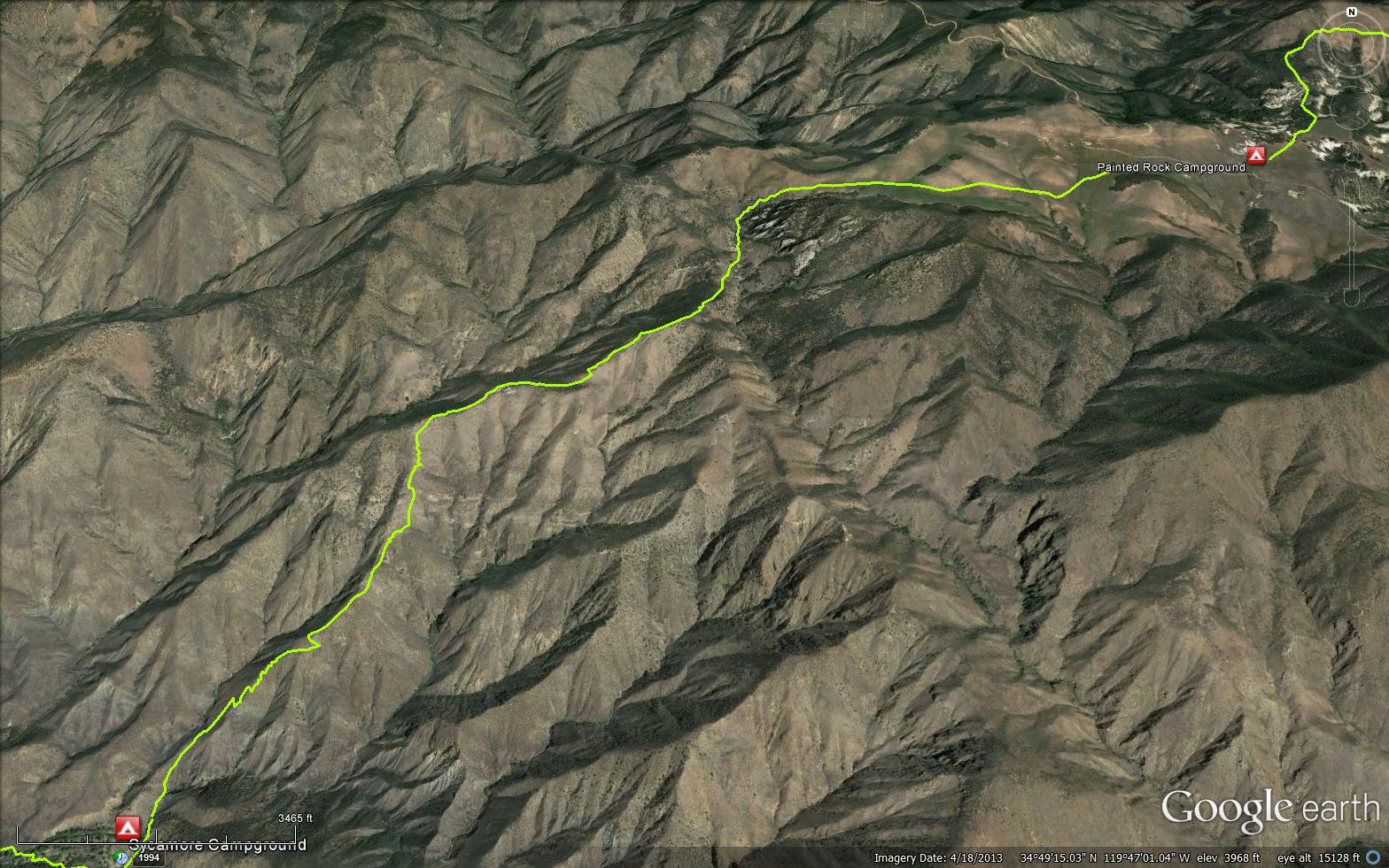
It was named after Mr. Jackson who ran cattle in the late 1890's on the Potreros on the crest of the Sierra Madre Mountains. The Jackson Spring is near the top of the climb the trail makes from Ed Montgomery's homestead on the Sisquoc River up to Montgomery Potrero where Josiah Montgomery, Ed's father, had a homestead. The trail starts at the Sycamore Camp (2000 feet) and thenclimbs passing Jackson Spring and Black Willow Spring to reach Montgomery Potrero.


 Jackson Trail Survey - 06-16-2024 - by Paul Muhl
| Link: | Jackson Trail |
| Date: | 06-16-2024 |
| Surveyor Name: | Paul Muhl |
| Trail description: | The trail is mostly overgrown. At the top where all the other cow trails are, without the tall white poles, it'd be much harder to figure out. It's narrow and easy to miss in the grass up top, sometimes covered in bushes midway or near the bottom. That said, I only "got lost" momentarily, once. This is a beautiful trail with incredible sweeping views that mostly follows ridges. It's very steep and there's no water so just come prepared. |
| Mode of transport: | Hike |
| Trail condition: | Needs some work |
| Condition details: | Steep and Beautiful |
| Images: | |
Jackson Trail Survey - 03-17-2024 - by Anonymous Surveyor| Link: | Jackson Trail |
| Date: | 03-17-2024 |
| Surveyor Name: | Anonymous Surveyor |
| Trail description: | Tons of cows at the top and the very bottom of the trail at the sisquoc is hard to find because of erosion but the trail as a whole is in pretty nice shape other than some steep sloping tread. |
| Mode of transport: | Hike |
| Trail condition: | Good shape and easy to follow |
| Images: | |
Jackson Trail Survey - 10-04-2017 - by Anonymous Surveyor| Link: | Jackson Trail |
| Date: | 10-04-2017 |
| Surveyor Name: | Anonymous Surveyor |
| Trail description: | Trail was in pretty good shape. There were unfenced cows (and a bull) at the uphill end near Sierra Madre Road. Give livestock a wide berth if present. |
| Mode of transport: | Hike |
| Trail condition: | Good shape and easy to follow |
Jackson Trail Survey - 04-18-2017 - by Jeff Wheelwright| Link: | Jackson Trail |
| Date: | 04-18-2017 |
| Surveyor Name: | Jeff Wheelwright |
| Trail description: | I should have added to the above report that this is a gorgeous hike (going down). |
| Mode of transport: | Hike |
| Trail condition: | Needs some work |
Jackson Trail Survey - 04-18-2017 - by Jeff Wheelwright| Link: | Jackson Trail |
| Date: | 04-18-2017 |
| Surveyor Name: | Jeff Wheelwright |
| Trail description: | The TH sign at Sierra Madre Road and Montgomery Potrero has collapsed. A large S.R. Wilderness sign a little ways off the road marks the actual start of the trail, but there was no trail because of the lush spring grass this year. Plus at least one of the distant trail marker posts had fallen over. You have to head for the grassy saddle in the SW. Don't be fooled by cow paths angling down to the south, as I was. Once over the saddle the trail is clear enough and the footing surprisingly good for such a precipitous descent. If you think you want to climb up this trail from the Sisquoc wearing a heavy pack, you ought to join the military or the circus. |
| Mode of transport: | Hike |
| Trail condition: | Needs some work |
| Images: | |
Jackson Trail Survey - 05-03-2016 - by Los Padres Forest Association| Link: | Jackson Trail |
| Date: | 05-03-2016 |
| Surveyor Name: | Los Padres Forest Association |
| Trail description: | At the top of Jackson Trail there are no sign in sheets. No water except rain water in the trough at Lamar's cabin. Lots of brome & hordeum in the portrero. Carsonite trail markers are all down. Jackson Trail is ok for stock, there is a big hole near the bottom that could be filled with rocks. |
| Mode of transport: | Stock |
| Trail condition: | Needs some work |
| Images: | |
 Survey / Report Form - Please click this box to open the form.