 Use Marker Groups
 Wolf 2002
Piru 2003
Day 2006
Zaca 2007
Gap 2008
La Brea 2009

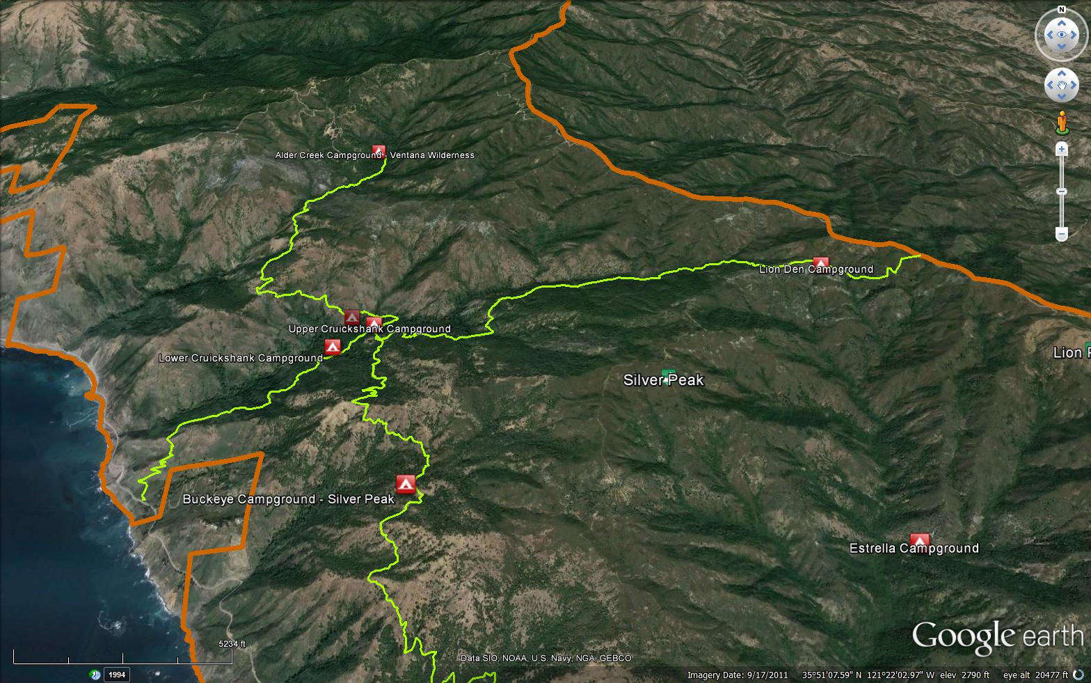
The Cruickshank Trail is a 6 mile trail in the Silver Peak Wilderness, located in Monterey County. The trail starts from Highway 1 and completes at the South Coast Ridge Road 20S05.6. The Buckeye Trail (5E09) crosses this trail about midway. The Cruickshank trail has beautiful views of the Pacific Ocean and meanders through oaks and into Redwood filled canyons.


 Cruickshank Trail Survey - 12-18-2024 - by rich scholl
| Link: | Cruickshank Trail |
| Date: | 12-18-2024 |
| Surveyor Name: | rich scholl |
| Trail description: | Silver camp in good shape-upper and lower areas |
| Mode of transport: | Hike |
| Trail condition: | Good shape and easy to follow |
Cruickshank Trail Survey - 12-18-2024 - by Rich Scholl| Link: | Cruickshank Trail |
| Date: | 12-18-2024 |
| Surveyor Name: | Rich Scholl |
| Trail description: | |
| Mode of transport: | Hike |
| Trail condition: | Good shape and easy to follow |
Cruickshank Trail Survey - 10-03-2022 - by Gary Felsman| Link: | Cruickshank Trail |
| Date: | 10-03-2022 |
| Surveyor Name: | Gary Felsman |
| Trail description: | *** VWA/USFS Volunteer Ranger/Trail Crew Report *** Description: Over the past week multiple VWA/USFS Volunteer Rangers and VWA Youth in Wilderness have been patrolling and exploring the Cruikshank Trail. These folks found multiple downed treed across the trail which have now been cleared by volunteer personnel. There is a small trickle at Lower Cruickshank Camp but may not be enough to collect. A trickle of water is flowing at Upper Cruickshank Camp just down the trail to Villa Creek Camp. Trail conditions are as follows: Highway 1 to Top of Switchbacks. - Wilderness Freeway to Clear, the lowest section has some minor encroaching brush. Once you reach the switchbacks, the trail is wide open to the wilderness boundary sign. Top of Switchbacks to Upper Cruickshank Camp - Passable, the 1/3 mile past the wilderness boundary sign has lots of encroaching brush pushing folks to the edge of the trail. The tread is well defined and easy to follow. Once you get past this section, the trail is clear with minor encroaching brush. Upper Cruickshank Camp to Silver Camp - Clear, with minor encroaching brush. Silver Camp to Rocky Outcropping - Passable, as there is still the slide past Silver Creek which is narrow in many places. Be careful when crossing the slide areas. Rocky Outcropping to Silver Peak Use Trail Road - Clear, with encroaching brush. Silver Peak Use Trail Road to Lion Den Camp - Clear, with minor encroaching brush. Lion Den to SCRR - Clear. |
| Mode of transport: | Hike |
| Trail condition: | Needs some work |
Cruickshank Trail Survey - 05-23-2022 - by Valinor223| Link: | Cruickshank Trail |
| Date: | 05-23-2022 |
| Surveyor Name: | Valinor223 |
| Trail description: | |
| Mode of transport: | Hike |
| Trail condition: | Needs some work |
| Condition details: | Trail is in good shape and easy to follow. Minor poison oak growing over the trail that is just barely avoidable as it encroaches onto the trail. Recommend wearing pants! |
Cruickshank Trail Survey - 10-26-2020 - by Anonymous Surveyor| Link: | Cruickshank Trail |
| Date: | 10-26-2020 |
| Surveyor Name: | Anonymous Surveyor |
| Trail description: | *** VWA/USFS Volunteer Ranger/Trail Crew Report *** Forest/Trail Status: CLOSED, Los Padres Monterey Ranger District is closed per Forest Order 05-07-51-20-22 Current Fire Restrictions: No Campfires, No Stoves in backcountry. Cold Camping Only. Description: With the Monterey Ranger District Forest still closed, VWA/USFS Volunteer Rangers continue to prepare for its reopening. Today volunteer Rangers patrolled from Highway 1 to Upper Cruickshank Camp. They cleaned Lower and Upper Cruickshank Camps. Made sure there were no smoldering or recent fires at each camp. They removed a large oak that had fallen across the trail about a mile in and another small tree just before Upper Cruickshank Camp. Water is still trickling at both camps. Trail conditions are as follows: Highway 1 to top of Switchbacks - Clear with no obstacles Switchbacks to Upper Cruickshank Camp - Clear with encroaching brush. |
| Mode of transport: | Hike |
| Trail condition: | Needs some work |
Cruickshank Trail Survey - 11-25-2018 - by Steve Cypher| Link: | Cruickshank Trail |
| Date: | 11-25-2018 |
| Surveyor Name: | Steve Cypher |
| Trail description: | The slide area above Silver Camp is as it has been for a few years. Hikers are crossing it but some are freaked out by it. Ventana Wilderness Alliance posted signs at the trailheads warning people to "Be prepared to turn back if you hike there and find that traversing this area is beyond your ability." An ACE trail crew did a beautiful job clearing two miles of brush tunnel above the slide over the last month. They didn't work the slide area at all because it was considered too dangerous. |
| Mode of transport: | Hike |
| Trail condition: | Needs some work |
| Condition details: | Sketchy slides - otherwise clear |
Cruickshank Trail Survey - 02-23-2018 - by Steve Cypher| Link: | Cruickshank Trail |
| Date: | 02-23-2018 |
| Surveyor Name: | Steve Cypher |
| Trail description: | Trail is a stock-passable freeway from Hwy 1 to Upper Cruickshank Camp. Hiking uphill (east) the trail is narrower to Silver Camp. Shortly above Silver Camp are some land slides with very narrow tread across and big, steep drops. Some have reported this area as dangerous, but it's been this way for years and many hikers pass safely. Know your limits. Above the slides are nearly 2 miles of brush tunnel with some poison oak. Doable with a backpack and frequent ducking. It gets better just below crossing the ridge with the old road up Silver Peak. |
| Mode of transport: | Hike |
| Trail condition: | Needs some work |
| Condition details: | Rough above Silver Camp |
| Images: | Sketchy slide above Silver Camp |
Cruickshank Trail Survey - 06-01-2015 - by Los Padres Forest Association| Link: | Cruickshank Trail |
| Date: | 06-01-2015 |
| Surveyor Name: | Los Padres Forest Association |
| Trail description: | The Ventana Wilderness Alliance completed the trail to pack stock standards from Highway 1 to Upper Cruickshank Camp in Spring 2015. |
| Mode of transport: | Array |
| Trail condition: | Good shape and easy to follow |
Cruickshank Trail Survey - 05-08-2016 - by Sherri| Link: | Cruickshank Trail |
| Date: | 05-08-2016 |
| Surveyor Name: | Sherri |
| Trail description: | This is my first time trail reporting. We started our hike at Cruickshank trailhead at PCH on Sunday. We hiked along this trail to the Buckeye junction. Then we hiked along the Buckeye trail to the Buckeye Camp that sits next to the spring. Spent one night there. Second day we retraced our hike on Buckeye trail but then continued on to Villa Creek Camp. Spent one night there. Trails were all clear, Villa Creek was full flowing. The spring at Buckeye Camp was also flowing but we did not feel comfortable dipping into water from the trough as there were unidentified organisms there. Instead, we captured our water from just above the trough. We also did a short hike beyond Villa Creek Camp heading toward Alder Creek Camp. This trail was very overgrown and probably where I came into contact with the poison oak that I later broke out from. There are beautiful views if you don't mind pushing through the overgrowth. |
| Mode of transport: | Hike |
| Trail condition: | Good shape and easy to follow |
| Images: | View from Cruickshank Trail Buckeye Camp Villa Creek Ready to pack it out from Villa Creek Camp Trail to Alder Creek Camp |
Cruickshank Trail Survey - 03-31-2015 - by Anonymous Surveyor| Link: | Cruickshank Trail |
| Date: | 03-31-2015 |
| Surveyor Name: | Anonymous Surveyor |
| Trail description: | Trail leading up to Lions Den camp is very eroded/crumbling after crossing the creek. Trail gets very narrow with steep drop off to the side. |
| Mode of transport: | Hike |
| Trail condition: | Needs some work |
 Survey / Report Form - Please click this box to open the form.