 Use Marker Groups
 Wolf 2002
Piru 2003
Day 2006
Zaca 2007
Gap 2008
La Brea 2009

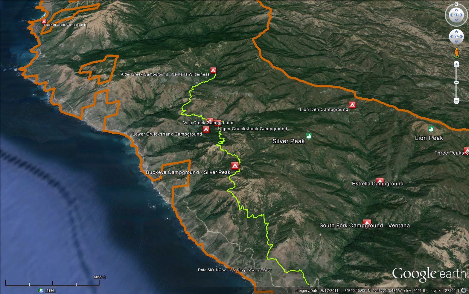
A beautiful trail that has ocean views and travels through oak groves, redwood groves, chaparral. A nice place to camp is at Villa Creek, the camp is set among redwood trees and the creek provides a tranquil sounds of flowing water. The Buckeye Trail is a 8.61 mile long trail in the Silver Peak Wilderness in Monterey County . The trail leads from Highway 1 near Salmon Creek and climbs up and over a few ridges and then completes at South Coast Ridge Road (20S05.6). Please let us know if you have explored this trail recently.


 Buckeye Trail Survey - 12-21-2024 - by Rich Scholl
| Link: | Buckeye Trail |
| Date: | 12-21-2024 |
| Surveyor Name: | Rich Scholl |
| Trail description: | |
| Mode of transport: | Hike |
| Trail condition: | Good shape and easy to follow |
Buckeye Trail Survey - 12-18-2024 - by Rich Scholl| Link: | Buckeye Trail |
| Date: | 12-18-2024 |
| Surveyor Name: | Rich Scholl |
| Trail description: | |
| Mode of transport: | Hike |
| Trail condition: | Good shape and easy to follow |
Buckeye Trail Survey - 04-17-2024 - by Rob| Link: | Buckeye Trail |
| Date: | 04-17-2024 |
| Surveyor Name: | Rob |
| Trail description: | Started on the buckeye trail in the north from alder creek camp heading south towards Cruickshank Camp. This single track trail has lots of shade, but is a little overgrown, and I had to spend about 15 minutes clearing a large fallen tree branch from the path. The trail is mostly clear and passable, with some encroaching poison oak and other vegetation. Mostly downhill, following the creek until after you cross it and enter the silver peak wilderness. There are some great views of the ocean after crossing the creek that make the whole hike worth it. After the ocean views, expect undergrowth and deadfall to get moderately worse and take a few short detours around various obstacles. For the Buckeye Trail, leading South out of villa Creek, I have two words: poison oak. It’s encroaching the trail for a mile at least. North Buckeye camp has a brand new picnic table and room for about three or four tents; water in nearby creek was flowing. The open grassy field nearby is beautiful. The campsite just to the south of the Buckeye flats overlooks the ocean and has the perfect place to watch the sunset. The trail from Buckeye to the salmon creek trail head is clear and well traveled, but encroached by poison oak at a few spots; needs a trim. Lots of shade leaving out of the camp. View to the south of the Hearst headlands and Piedras Blancas is gorgeous and the terrain opens up as we lose the shade for a little while. Several creeks on the way were flowing in late April, with a couple of really nice waterfalls. The last mile to the closed ranger station is mostly coastal scrub, no trees, no shade. Recommend hiking this portion of the trail in the morning or the late afternoon. |
| Mode of transport: | Hike |
| Trail condition: | Needs some work |
| Condition details: | Poison Oak and deadfall |
| Images: | Just north of Villa Creek, looking west Alder Creek View looking south of Buckeye Flat Buckeye Camp Ocean view |
Buckeye Trail Survey - 03-25-2024 - by Kaylynn OCurran| Link: | Buckeye Trail |
| Date: | 03-25-2024 |
| Surveyor Name: | Kaylynn OCurran |
| Trail description: | A lot of poison oak and ivy during the first half mile of this trail, to the point that it is impossible to not brush up against it. I suggest not bringing animals as bringing my dog resulted in her getting poison oak. We had about 6 or 7 ticks on us. Lots of flowing water and maybe 4 or 5 downed trees that you have to crawl over or under. Trail isn't too overgrown at all, only in the very beginning. Not muddy really at all. Beautiful weather we got and gorgeous views at Buckeye Camp! Really great experience and conditions overall. |
| Mode of transport: | Array |
| Trail condition: | Needs some work |
| Condition details: | Lots of poison oak and ivy and ticks! |
Buckeye Trail Survey - 06-09-2023 - by Anonymous Surveyor| Link: | Buckeye Trail |
| Date: | 06-09-2023 |
| Surveyor Name: | Anonymous Surveyor |
| Trail description: | Tree down across trail at this location : 35.82842, -121.37408 10S 0646864E 3966138N |
| Mode of transport: | Hike |
| Trail condition: | Needs some work |
| Condition details: | Lots of overgrowth to push through including poison oak. |
Buckeye Trail Survey - 04-16-2021 - by Slokal| Link: | Buckeye Trail |
| Date: | 04-16-2021 |
| Surveyor Name: | Slokal |
| Trail description: | Great Trail all the way to Villa Creek. A tad overgrown beyond that, but still very easy to follow. Plenty of water at Buckeye, Villa creek and Alder creek. |
| Mode of transport: | Hike |
| Trail condition: | Good shape and easy to follow |
| Images: | |
Buckeye Trail Survey - 03-05-2021 - by Anonymous Surveyor| Link: | Buckeye Trail |
| Date: | 03-05-2021 |
| Surveyor Name: | Anonymous Surveyor |
| Trail description: | Beautiful Day, sunny, cool/warm. There was one large dead tree that broke and blocked the trail but one can go over it well enough. There was only one good flowing creek that is half way from Salmon Creek parking area to Buckeye Camp. Great variety of wildflowers to be enjoyed today: Indian paintbrush, sweet pea, ceanothus, milk maids (white and lavender), Johnny jump ups, trefoil, three types of lupin, shooting stars (meadow of them south of Buckeye Camp) thimble berry, wild strawberry (a couple with fruit, but not ripe yet), blue dicks, California poppy, purple nightshade, chocolate Lillies, bay laurels are blooming too and quite a few others that I do not know the name of. |
| Mode of transport: | Hike |
| Trail condition: | Good shape and easy to follow |
Buckeye Trail Survey - 11-18-2017 - by Andrew| Link: | Buckeye Trail |
| Date: | 11-18-2017 |
| Surveyor Name: | Andrew |
| Trail description: | Great condition, with trail workers currently working on it. Water was trickling in a few places between the Buckeye TH and Buckeye camp with a trickle at the camp. Small flow at Soda Springs and then good flowing water at Villa Creek. |
| Mode of transport: | Hike |
| Trail condition: | Good shape and easy to follow |
| Images: | |
Buckeye Trail Survey - 07-31-2016 - by Ecduzit| Link: | Buckeye Trail |
| Date: | 07-31-2016 |
| Surveyor Name: | Ecduzit |
| Trail description: | Trail is pretty good but it is not easy. Reaching Silver Peak is a bushwack attack! |
| Mode of transport: | Hike |
| Trail condition: | Good shape and easy to follow |
Buckeye Trail Survey - 08-04-2017 - by Anonymous Surveyor| Link: | Buckeye Trail |
| Date: | 08-04-2017 |
| Surveyor Name: | Anonymous Surveyor |
| Trail description: | Water at Buckeye Camp flowing well Aug4, 2017 |
| Mode of transport: | Hike |
| Trail condition: | Good shape and easy to follow |
| Images: | |
Buckeye Trail Survey - 07-10-2017 - by Alan Curtis| Link: | Buckeye Trail |
| Date: | 07-10-2017 |
| Surveyor Name: | Alan Curtis |
| Trail description: | My son and I hiked up the Buckeye Trail to Buckeye Camp on July 8 2017. Â There are spectacular views and we had the place to ourselves. Â We met two hikers on the 9th as we were returning to the trail head. Â There are a few sketchy spots on the trail with loose gravel and rock along steep drop offs. Â I'm 58 and was carrying a 30 lb pack, so it is doable, but an easy hike this trail is not. Â There are two or three running water sources between the trail head and the camp. Â They look seasonal so I wouldn't depend on these later in the year. Â The last water source was about two miles from the camp. Â I consumed 4 liters of water on the hike (it was 85-90 degrees) and was extremely happy to see water running out of the pipe at Buckeye Spring. Â There are two campsites around the meadow at Buckeye. Â One of them has a rickety picnic table under a spread of huge oak trees. Â This is the one closest to the spring. Â A large snake was drowsing at the entrance to a hole in the base of the main tree so be careful, it's right next to the path from the table to the spring. Â There was also some annoying TP litter at the base of one of the other trees. Â The other site is 150 yards or so NW, and was a little nicer so we stayed there. Â Swarms of gnats were a constant nuisance at both sites. There is lots and lots of poison oak on this trail. Â Most of it was avoidable, but a couple of spots had it hanging from both sides of the trail and it was basically impossible to get by without brushing some parts of your body. Â I highly recommend long pants and hiking poles on this trail. All in all it's a challenging but beautiful trail. Â Â Â |
| Mode of transport: | Hike |
| Trail condition: | Needs some work |
| Condition details: | A few downed trees and quite a bit of overly aggressive poison oak. |
| Images: | Waterfall about 1.5 miles from the trailhead. View south from the trail. No more water until Buckeye. |
Buckeye Trail Survey - 06-01-2016 - by Los Padres Forest Association| Link: | Buckeye Trail |
| Date: | 06-01-2016 |
| Surveyor Name: | Los Padres Forest Association |
| Trail description: | Ventana Wilderness Alliance worked the Buckeye Trail in Spring 2016 from Upper Cruikshank Camp to Buckeye Camp. Â It is passable for stock. Â Great work! Â They also brushed the trail from Salmon Creek Station out to the Soda Springs junction. |
| Mode of transport: | Array |
| Trail condition: | Good shape and easy to follow |
Buckeye Trail Survey - 06-01-2015 - by Los Padres Forest Association| Link: | Buckeye Trail |
| Date: | 06-01-2015 |
| Surveyor Name: | Los Padres Forest Association |
| Trail description: | Ventana Wilderness Alliance completed the trail from Upper Cruickshank Camp to Villa Creek Camp to hiker/pedestrian standards in Spring 2015. |
| Mode of transport: | Array |
| Trail condition: | Needs some work |
Buckeye Trail Survey - 04-19-2016 - by Donald seawater| Link: | Buckeye Trail |
| Date: | 04-19-2016 |
| Surveyor Name: | Donald seawater |
| Trail description: | https://www.youtube.com/watch?v=y2DxCzlBkXs |
| Mode of transport: | Hike |
| Trail condition: | Good shape and easy to follow |
Buckeye Trail Survey - 04-19-2016 - by Donald seawater| Link: | Buckeye Trail |
| Date: | 04-19-2016 |
| Surveyor Name: | Donald seawater |
| Trail description: | https://www.youtube.com/watch?v=y2DxCzlBkXs |
| Mode of transport: | Hike |
| Trail condition: | Good shape and easy to follow |
Buckeye Trail Survey - 07-17-2015 - by Los Padres Forest Association| Link: | Buckeye Trail |
| Date: | 07-17-2015 |
| Surveyor Name: | Los Padres Forest Association |
| Trail description: | Below is an article from the Monterey County Weekly about a Summer 2015 backpack along the Buckeye Trail. Â Worth a read if you are looking at this trail: http://www.montereycountyweekly.com/blogs/monterey-naturally-part-v-a-night-beneath-the-stars-on/article_87184dba-2b50-11e5-9898-9b23670a0ecc.html |
| Mode of transport: | Hike |
| Trail condition: | Good shape and easy to follow |
 Survey / Report Form - Please click this box to open the form.