 Use Marker Groups
 Wolf 2002
Piru 2003
Day 2006
Zaca 2007
Gap 2008
La Brea 2009

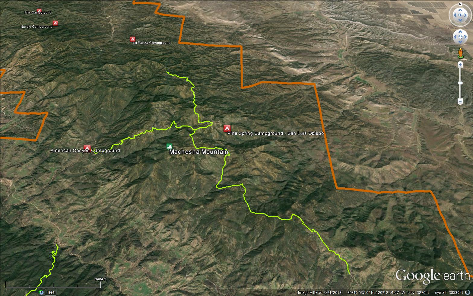
The Castle Crags Trail is an 11 mile trail in the Machesna Wilderness in San Luis Obispo County, the trail connects the Pine Mountain Trail and the Los Pelados Road (31S10). The trail is named after the impressive Castle Crags rock formation found before the junction with the Pine Mountain Trail.


 Castle Crags Trail Survey - 05-22-2026 - by Anonymous Surveyor
| Link: | Castle Crags Trail |
| Date: | 05-22-2026 |
| Surveyor Name: | Anonymous Surveyor |
| Trail description: | I began from 29S18 (labelled on some maps as an extension of Pine Mountain Rd and some maps as Queen Bee Rd). I drove up 29S18 from Pozo Rd in a 2wd vehicle easily, and probably could have continued driving up the first couple miles of Pine Mtn Trail to Castle Crags Trail. I split off at Castle Crags Trail, there is a register nearby at (35.32599, -120.23948) that is sorely in need of a new notebook. No water on the route, expect temperatures to be similar or higher than the forecast in Pozo. I followed the trail out to (35.30220, -120.22200) and then tried bushwhacking down to the castle crags formation. I only made it about a half mile before cutting my losses, climbing a tree, and enjoying the view. No ticks, no poison oak, but the flies are evil and will bite you through your clothing. |
| Mode of transport: | Hike |
| Trail condition: | Needs some work |
| Condition details: | Easy to follow for the most part, but nonexistent to hike out to the Castle Crags formation itself |
| Images: | castle crags from (35.30205, -120.21740) |
Castle Crags Trail Survey - 07-09-2023 - by Brian Roberts| Link: | Castle Crags Trail |
| Date: | 07-09-2023 |
| Surveyor Name: | Brian Roberts |
| Trail description: | The trail needs some work. A ton of bushwhacking required to get from end to end. However, it's generally pretty easy to remain on course. |
| Mode of transport: | Hike |
| Trail condition: | Needs some work |
| Condition details: | Very brushy but not hard to follow |
Castle Crags Trail Survey - 10-18-2016 - by Mike Splain| Link: | Castle Crags Trail |
| Date: | 10-18-2016 |
| Surveyor Name: | Mike Splain |
| Trail description: | Section- American Canyon Trail junction to Machesna Mountain summit spur- Besides a few cattle trails in the blue oak woodlands, this section of the trail is wide open & easily followed. Side note- The unofficial dozer line/spur to Machesna Mountain ranges from wide open to heavily overgrown bushwhacking, but stellar views from Santa Lucia Peak (Ventana Wilderness) to the San Rafael, Sierra Madre, Thorn Point, Mount Pinos & the Carrizo Plain/Temblor Range make it well worth the effort. |
| Mode of transport: | Hike |
| Trail condition: | Good shape and easy to follow |
 Survey / Report Form - Please click this box to open the form.