 Use Marker Groups
 Wolf 2002
Piru 2003
Day 2006
Zaca 2007
Gap 2008
La Brea 2009

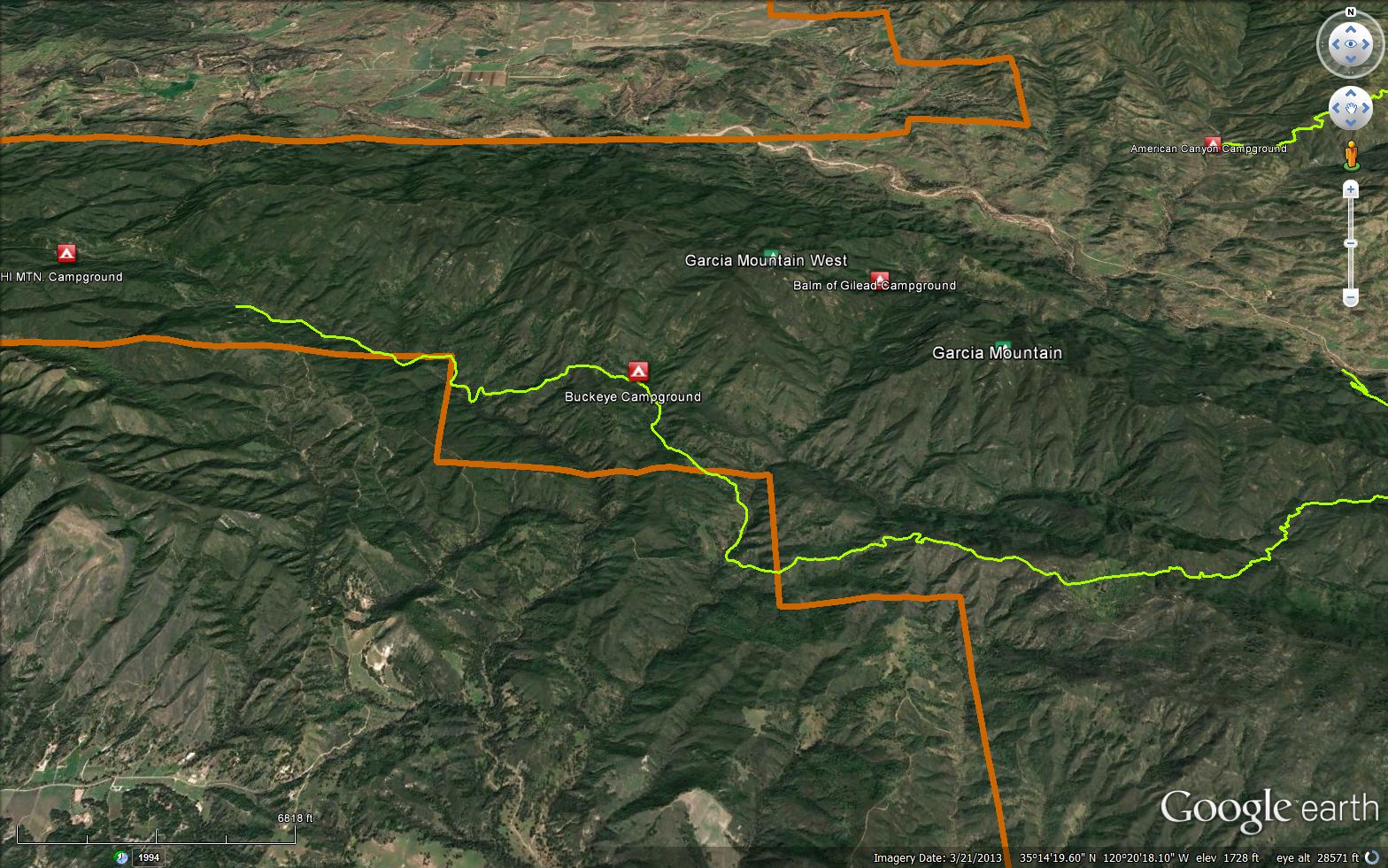
From Trailhead at Hi Mountain Road the trail meanders along Trout Creek which sometimes has water. It is a pleasant trail. It then leaves the canyon bottom at an unsigned junction and climbs through rolling hills to Buckeye Campsite. There is a small spring here with generally reliable water. Camping is tough if you follow the rule of never camping under an oak tree as the Campsite is within a pleasant oak grove. The T-C trail continues through rolling country to Stony Creek Meadow (Stony Creek is not reliable water, it may be dry) on private land, pass through this and ascend to Caldwell Mesa, 1300 feet gain in 2 miles. Can be hot, no water. Caldwell Mesa is a lovely tableland, on private land, no camping, can be over grazed. There is a spring which is unreliable. The trail continues, drops 600 feet to Stony Junction, there is usually reliable water in the small stream leading to Stony Creek. Good camping although not in an official FS campsite. This is the end of the trail. A right turn here will put you on the Stony Creek Trail which dead ends at private land in a couple of miles. No particular reason to use it. A left turn takes you down the Stony Creek trail to a dead end in a mile or so. Continuing straight across the small meadow, crossing Stony Creek puts you on the Avenales Guard Station Trail which is a scenic climb up over the ridge and down to the Guard Station which is also a dead end at private land. All of the Garcia Wilderness Trails are out and back trails with no other legal ingress or egress except the Trout Creek Trailhead.


 Caldwell Trout Creek Trail Survey - 09-15-2024 - by Michael Lee
| Link: | Caldwell Trout Creek Trail |
| Date: | 09-15-2024 |
| Surveyor Name: | Michael Lee |
| Trail description: | Rode from the Mesa down west for 1.5 miles. Overgrown, certainly a bushwhack, but manageable to the point where a large trail crew could knock out a lot of work really fast. Would be super sick to see this part of SLO get revitalized, underrated portion of the Los Padres |
| Mode of transport: | Bicycle |
| Trail condition: | Hard to follow |
Caldwell Trout Creek Trail Survey - 03-26-2021 - by Los Padres Forest Association| Link: | Caldwell Trout Creek Trail |
| Date: | 03-26-2021 |
| Surveyor Name: | Los Padres Forest Association |
| Trail description: | LPFA Trail Crew with support from SLOPOST spent parts of three weeks clearing the Trout Creek Trail from Hi Mtn Road out to the Sellers Junction. All trees cleared, creek crossings defined and some trail signs repaired and installed. Stock passable. Enjoy! |
| Mode of transport: | Hike |
| Trail condition: | Good shape and easy to follow |
Caldwell Trout Creek Trail Survey - 04-09-2021 - by JB| Link: | Caldwell Trout Creek Trail |
| Date: | 04-09-2021 |
| Surveyor Name: | JB |
| Trail description: | Fantastic trail, great tread, clear, no downed trees or other blockages, tons of ticks, wildflowers in bloom. Followed as far as Sellers Potrero Trail. Water bubbling up at various points in creek which goes underground. Trout in creek. Turtle spotted in creek. TONS of poison oak. Nice new signage and walk-through at Hi Mtn. Road trailhead. |
| Mode of transport: | Array |
| Trail condition: | Good shape and easy to follow |
Caldwell Trout Creek Trail Survey - 03-06-2021 - by Steve Cypher| Link: | Caldwell Trout Creek Trail |
| Date: | 03-06-2021 |
| Surveyor Name: | Steve Cypher |
| Trail description: | Hiked from Stony Creek to Buckeye Camp. Trail is good to Caldwell Mesa. Some brushy spots on the way back down to lower Stony Creek. Several cow & ranch trails confuse the route on lower Stony Creek. Epic poison oak on the way to Buckeye Camp. A few logs across the trail. |
| Mode of transport: | Hike |
| Trail condition: | Needs some work |
| Condition details: | Remote and beautiful |
Caldwell Trout Creek Trail Survey - 01-03-2021 - by Anonymous Surveyor| Link: | Caldwell Trout Creek Trail |
| Date: | 01-03-2021 |
| Surveyor Name: | Anonymous Surveyor |
| Trail description: | A friend and I hiked from the trailhead on Hi Mtn Road to Buckeye camp. We were out there December 28th - 30th. There was a lot poison oak growing on either side of the trail during the 1st part of the hike near the stream beds. However, we're not very sensitive and it was fairly easy to avoid. Later, there were sections with chaparral (mostly sage) growing across the trail. This was easy to push past but it provided a way for ticks to get on my hiking partner. We stopped every once in awhile to brush them off his clothes. No bites, thankfully. There was water flowing at two stream crossings on the way to Buckeye and also at Buckeye camp. |
| Mode of transport: | Hike |
| Trail condition: | Needs some work |
| Condition details: | Trailhead to Buckeye - Slightly overgrown and plenty of water |
| Images: | Stream at Buckeye camp This sign is near a fork in the trail. It marks the way to Buckeye. |
Caldwell Trout Creek Trail Survey - 10-13-2019 - by Nico Boyd| Link: | Caldwell Trout Creek Trail |
| Date: | 10-13-2019 |
| Surveyor Name: | Nico Boyd |
| Trail description: | |
| Mode of transport: | Stock |
| Trail condition: | Needs some work |
| Condition details: | Trout Creek has some water in it close to the trail head. LOTS of poison oak from the trailhead to Buckeye camp. There are a few trees blocking the trail but you can get around. |
Caldwell Trout Creek Trail Survey - 06-13-2019 - by Anonymous Surveyor| Link: | Caldwell Trout Creek Trail |
| Date: | 06-13-2019 |
| Surveyor Name: | Anonymous Surveyor |
| Trail description: | |
| Mode of transport: | Hike |
| Trail condition: | Needs some work |
| Condition details: | Lots of poison oak over taking the trail. |
Caldwell Trout Creek Trail Survey - 03-18-2019 - by Darrin| Link: | Caldwell Trout Creek Trail |
| Date: | 03-18-2019 |
| Surveyor Name: | Darrin |
| Trail description: | hiked trail from Stony Creek Trail jct over the Mesa as far as Lower Stony Creek. Large tree has fallen and taken out trail sign right at jct. with Stoney Creek Trail. Easy to miss junction. |
| Mode of transport: | Hike |
| Trail condition: | Good shape and easy to follow |
| Images: | Stony Creek Trail and Caldwell Trail Junction |
Caldwell Trout Creek Trail Survey - 03-13-2018 - by Mike Maki| Link: | Caldwell Trout Creek Trail |
| Date: | 03-13-2018 |
| Surveyor Name: | Mike Maki |
| Trail description: | Hiked this entire trail westbound as part of a section hike of the Condor Trail. I thought it was in good shape and easy to follow. Even saw some trout in Trout Creek! Trout creek has good amount of water in some sections and dry in others. Amazing trout survive. Lots of ticks in some sections. I forgot to treat my pants with permethrin. Caldwell Mesa is awesome! |
| Mode of transport: | Hike |
| Trail condition: | Needs some work |
| Condition details: | Some downed tress and encroaching vegetation |
| Images: | Ticks from one brush with veg. Forgot to treat with permethrin! Trout Creek Sign One of the downed trees. General condition of trail. Good water |
Caldwell Trout Creek Trail Survey - 04-16-2016 - by Jeff Wheelwright| Link: | Caldwell Trout Creek Trail |
| Date: | 04-16-2016 |
| Surveyor Name: | Jeff Wheelwright |
| Trail description: | Best to approach the TH from Lopez Lake rather than Pozo because Hi Mountain Road was in bad shape from the latter. In mid-April we hiked over three days to a point about half way up the mesa and back. Trail was in fine shape along Trout Creek, which has intermittent water. Trail to Buckeye Camp was only fair, with much poison oak to avoid and many step-arounds. Buckeye Camp has ample water. Trail from Buckeye to the mesa was occasionally hard to follow. Cattle have been keeping it open, but the meadows were lush and not overgrazed. Wildflowers were abundant everywhere. For a treat, look for a swath of rare snowdrop bushes on the north-facing slope at about 2K elevation west of the mesa--about 7 miles from the TH if you hike it straight. |
| Mode of transport: | Hike |
| Trail condition: | Needs some work |
| Images: | Snowdrop bush west of Caldwell Mesa |
 Survey / Report Form - Please click this box to open the form.