 Use Marker Groups
 Wolf 2002
Piru 2003
Day 2006
Zaca 2007
Gap 2008
La Brea 2009

Constructed by Ronald "Willie" Forsyth as a short cut trail from his pack station at what is now Sage Hill Group Camp to Upper Oso Camp and on up the Santa Cruz Trail to the back country. A school group and the L.P.F.A. (Los Padres Forest Association) developed the nature trail. The trail is maintained by the L.P.F.A.
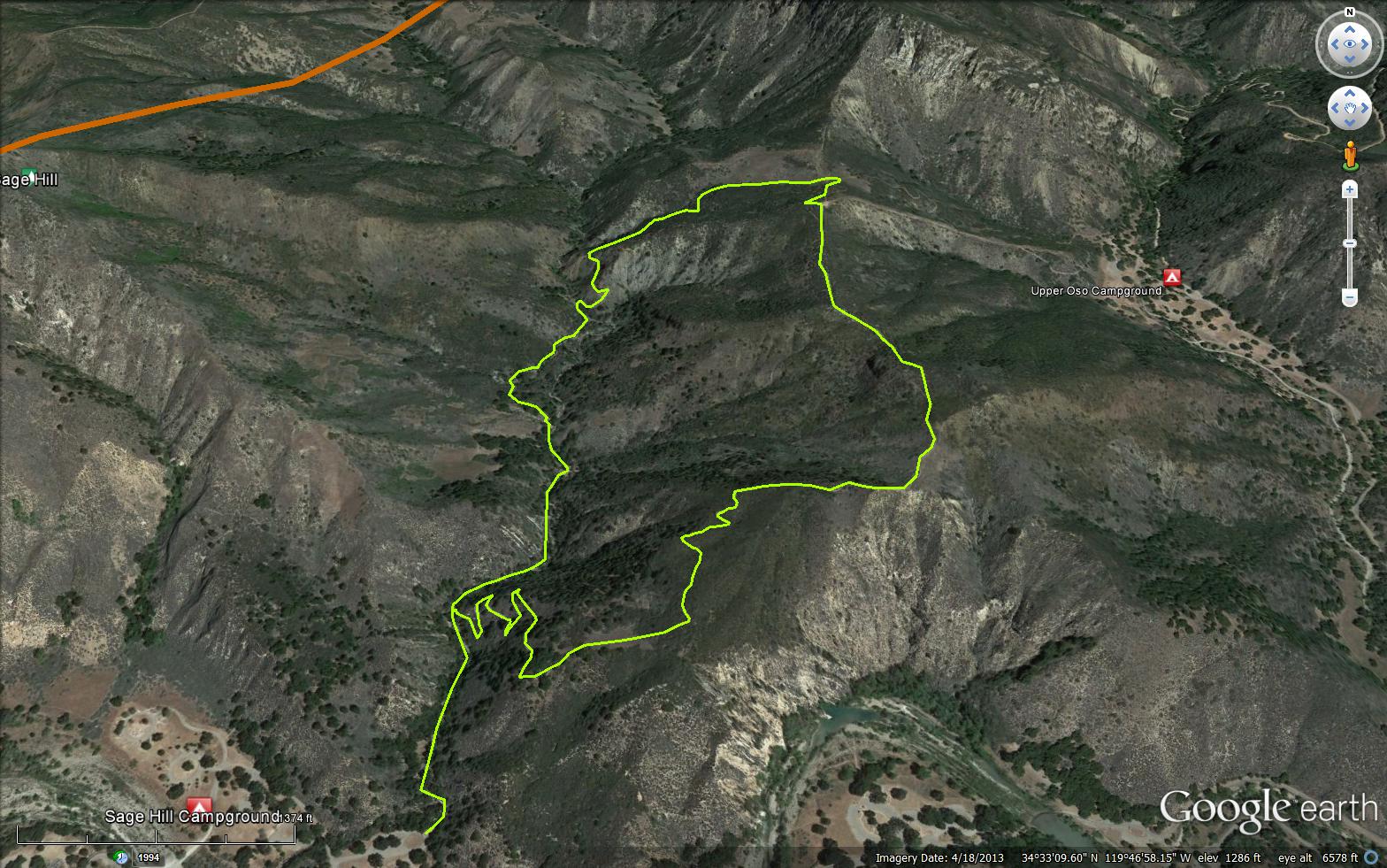
Opportunity for a shady 1 mile hike along Aliso Creek or a more strenuous 3.5 mile loop. The first mile is also a self-guided interpretive trail. The walk along the ridgetop offers views of the Santa Ynez River. The loop trail can also be accessed from Upper Oso Campground. Easy 1 mile hike along Aliso Creek or difficult 3.5 mile loop. In Lower Santa Ynez Recreation Area. Elevation gain 1400 feet. Directions: From Santa Barbara Hwy 101, 10 miles NW on Hwy 154, 4.5 miles East on Paradise, turn left at Ranger Station, go 1/2 mile to Sage Hill Group Campground. Trailhead parking lot is near loop 5.
SageHill Campground - Car Camping
Upper Oso Campground - Car Camping


 Aliso Loop Trail Survey - 10-03-2021 - by Stan
 | Link: | Aliso Loop Trail |
| Date: | 10-03-2021 |
| Surveyor Name: | Stan |
| Trail description: | Completed the loop counter clockwise. The trail was in good condition and easy to follow. Hot and dry. Many of the number markers for the interpretive trail are damaged and/or missing numbers. |
| Mode of transport: | Hike |
| Trail condition: | Good shape and easy to follow |
Aliso Loop Trail Survey - 11-29-2018 - by Anonymous Surveyor| Link: | Aliso Loop Trail |
| Date: | 11-29-2018 |
| Surveyor Name: | Anonymous Surveyor |
| Trail description: | A great trail! I hike it about every two weeks. |
| Mode of transport: | Hike |
| Trail condition: | Good shape and easy to follow |
Aliso Loop Trail Survey - 11-01-2018 - by Anonymous Surveyor| Link: | Aliso Loop Trail |
| Date: | 11-01-2018 |
| Surveyor Name: | Anonymous Surveyor |
| Trail description: | Â Â Â Â and will do it many times in the future |
| Mode of transport: | Hike |
| Trail condition: | Good shape and easy to follow |
Aliso Loop Trail Survey - 10-13-2018 - by Pat Fish| Link: | Aliso Loop Trail |
| Date: | 10-13-2018 |
| Surveyor Name: | Pat Fish |
| Trail description: | I rode this trail on my mule with two horse riding companions, from the terminus at the Upper Oso Campground up the hills, along the ridges, then down to Sage Hill Campground. The trail is easy to follow, with the exception that after you head out of the Upper Oso campground there will be a place where there is one collapsed bit of trail that I think will get worse soon. It is washed out, and you have to go off the trail and use some young Yucca whipplei for footholds. It has sketchy wooden reinforcements that badly need to be replaced. Other than that, a fine trail. Above the Upper Oso campground you will come to a fork, with an option to continue to go straight up or to the right and you will want to choose those switchbacks on the right. There are no warnings posted about the condition of the Aliso Canyon but people I met said they got to the shale part of it and turned around, and other people have told me it is closed. But there were no warnings on the trail signage. A blog post with many images fro this ride is online at :Â Â Â Â Â Â Â http://www.muletrail.com/2018/10/20181013-aliso-loop-and-oso-canyon.html |
| Mode of transport: | Stock |
| Trail condition: | Needs some work |
| Condition details: | Fine trail but there is one collapsed section |
| Images: | looking at the Aliso ridge from the First Crossing parking lot turning onto the Aliso from Upper Oso campground collapsed section of Aliso Loop trail detail of collapsing section of trail wonderful views from Aliso Loop trail |
Aliso Loop Trail Survey - 03-28-2017 - by Los Padres Forest Association| Link: | Aliso Loop Trail |
| Date: | 03-28-2017 |
| Surveyor Name: | Los Padres Forest Association |
| Trail description: | Nice article by ValHikes featuring Sage Hill Campground and the Aliso Loop Trail. Â Enjoy...... http://valhikes.blogspot.com/2017/03/sage-hill.html?utm_source=feedburner&utm_medium=email&utm_campaign=Feed%3A+MomentsInDirtAndInk+%28Moments+in+Dirt+and+Ink%29 |
| Mode of transport: | Hike |
| Trail condition: | Needs some work |
Aliso Loop Trail Survey - 03-06-2017 - by Los Padres Forest Association| Link: | Aliso Loop Trail |
| Date: | 03-06-2017 |
| Surveyor Name: | Los Padres Forest Association |
| Trail description: | Report from C Orr: some major slides after the winter storms, one in particular where the trail is gone. Â They have since been repaired. |
| Mode of transport: | Bicycle |
| Trail condition: | Needs some work |
| Images: | Trail Gone! Photo COrr |
Aliso Loop Trail Survey - 01-30-2017 - by Chris Orr| Link: | Aliso Loop Trail |
| Date: | 01-30-2017 |
| Surveyor Name: | Chris Orr |
| Trail description: | Removed tree from Aliso Ridge Trail (2nd switchback or southern switchbacks). Â Main trunk off trail on upslope will need to be removed at some time. |
| Mode of transport: | Bicycle |
| Trail condition: | Good shape and easy to follow |
| Images: | Before After |
Aliso Loop Trail Survey - 01-28-2017 - by Craig R. Carey| Link: | Aliso Loop Trail |
| Date: | 01-28-2017 |
| Surveyor Name: | Craig R. Carey |
| Trail description: | The Green Bars of Ventura Boy Scout Troop 111 hiked the loop from Sage Hill — great weather, and recent rains have greened things up considerably. A few small slides on the upper stretch, and one tree down across the southern switchbacks, but no major damage from the rains. |
| Mode of transport: | Hike |
| Trail condition: | Good shape and easy to follow |
| Images: | |
Aliso Loop Trail Survey - 11-04-2015 - by Los Padres Forest Association| Link: | Aliso Loop Trail |
| Date: | 11-04-2015 |
| Surveyor Name: | Los Padres Forest Association |
| Trail description: | Report from Ranger Rik: Picked up all blow down limbs on trail. Trail is in good shape with little water
damage. |
| Mode of transport: | Hike |
| Trail condition: | Good shape and easy to follow |
Aliso Loop Trail Survey - 04-11-2015 - by Constance| Link: | Aliso Loop Trail |
| Date: | 04-11-2015 |
| Surveyor Name: | Constance |
| Mode of transport: | Hike |
| Trail condition: | Good shape and easy to follow |
Aliso Loop Trail Survey - 01-04-2015 - by Doug| Link: | Aliso Loop Trail |
| Date: | 01-04-2015 |
| Surveyor Name: | Doug |
| Trail description: | All of this trail area was burnt during the White Fire in May of 2013. I rode the switch back section of this trail to Upper Oso and back. Did not take the canyon portion. While alot of the vegiation is gone to the fire, the trail is still in good condition. |
| Mode of transport: | Stock |
| Trail condition: | Good shape and easy to follow |
Aliso Loop Trail Survey - 12-13-2014 - by FP| Link: | Aliso Loop Trail |
| Date: | 12-13-2014 |
| Surveyor Name: | FP |
| Mode of transport: | Hike |
| Trail condition: | Needs some work |
| Condition details: | Recent rains have eroded several sections of the trail. Rock and gravel slides have covered spots here and there. But trail is easily followed. |
 Survey / Report Form - Please click this box to open the form.