 Use Marker Groups
 Wolf 2002
Piru 2003
Day 2006
Zaca 2007
Gap 2008
La Brea 2009

| Date | Surveyor | Water Report |
| 10-13-2018 | Pat Fish | Dry |
| 11-18-2017 | Anonymous Surveyor | Dry |
| 11-22-2015 | Anonymous Surveyor | Dry |
| 01-03-2015 | Doug | Dry |
Nestled in the Santa Ynez Mountain Range, Sage Hill Campground is a great group camping spot with easy access to the Santa Ynez River. Spend time fishing or take in the epic scenery on one of the trails designed for both hikers and horseback riders. One of the campsites is designed for group equestrian camping and includes 12 corrals and a hitching post.
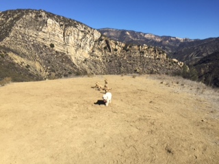
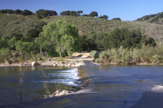
The campground sits in a flat area with some sites shaded by oak trees. Sage Hill is near the river, which flows into Cachuma Lake about seven miles west. The Santa Ynez Mountains make up part of the Transverse Range along the Pacific Coast of California. The landscape may become very dry by mid-summer.
Fishermen are likely to find carp, catfish, bluegill and the occasional bass that swim up from Cachuma. The Aliso Canyon Trail begins at the rear of the facility and continues to Upper Oso Campground, which is where the Santa Cruz Trail begins.
The nearby Cachuma Lake Recreation Area is perfect for boating, fishing and kayaking.
Each campsite accommodates up to 50 people, and the group equestrian site accommodates up to 60.
Flush toilets, drinking water and paved roads are included, in addition to an extra large parking area to accommodate horse trailers.
The closest dump station is at Cachuma Lake.
The campground is half an hour from the thriving beach city of Santa Barbara.


 Sage Hill Campground Survey - 10-13-2018 - by Pat Fish
| Link: | Sage Hill Campground |
| Date: | 10-13-2018 |
| Surveyor Name: | Pat Fish |
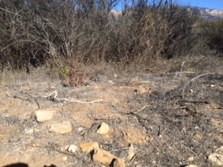
| Camp Description: | The river is completely dry now. Sage Hill Camp is clean and nicely maintained and the paddocks at Caballo look intact and in good order. The trail up the Aliso Loop is in good condition except for one washout just above Upper Oso Campground at the other end that can be navigated around with care. The Aliso Canyon trail has a section of collapsed shale that equestrians voted as impassible and hikers also said they turned around and did not attempt. The Canyon trail is a narrow single-track with a steep drop-off and would be difficult to turn a horse on and so should be avoided. Here is a blog post with photos of nearby trails:   http://www.muletrail.com/2018/10/20181013-aliso-loop-and-oso-canyon.html |
| Water Source: | Dry |
| Water Source Details: | Santa Ynez River a dry trail |
| Weather Conditions: | bright sunny day 74 degrees |
| Images: | Oso Canyon trail in creekbed Santa Ynez River at First Crossing |
Sage Hill Campground Survey - 11-18-2017 - by Anonymous Surveyor| Link: | Sage Hill Campground |
| Date: | 11-18-2017 |
| Surveyor Name: | Anonymous Surveyor |
| Camp Description: | |
| Water Source: | Dry |
| Water Source Details: | |
| Weather Conditions: |
Sage Hill Campground Survey - 11-22-2015 - by Anonymous Surveyor| Link: | Sage Hill Campground |
| Date: | 11-22-2015 |
| Surveyor Name: | Anonymous Surveyor |
| Camp Description: | very dry and not a lot of shade. it is very evident that a fire when thru the area, burnt areas. great to see the new growth but still so dry and hot. very few wildflowers. its a challenge and I'm in pretty good shape. took us about 1.5 hours and the trail was about 3.33 miles. bring water! |
| Water Source: | Dry |
| Water Source Details: | |
| Weather Conditions: | 76 |
| Images: | |
Sage Hill Campground Survey - 01-03-2015 - by Doug| Link: | Sage Hill Campground |
| Date: | 01-03-2015 |
| Surveyor Name: | Doug |
| Camp Description: | Rode the switch back trail (Aliso) to upper oso and back. Stayed on the switch back and did not go through the canyon split. Trail was good, not much storm damage, but vast amount of vegiation lost due to White Fire (spring 2013). Currently Sage Hill and Upper Oso camping closed. Day use parking at Sage Hill / Aliso trail head open. |
| Water Source: | Dry |
| Water Source Details: | No water at trail head on Sage Hill side. Water at Upper Oso |
| Weather Conditions: | Cold morning in low 30's warming to low 60s by afternoon |
 Survey / Report Form