 Use Marker Groups
 Wolf 2002
Piru 2003
Day 2006
Zaca 2007
Gap 2008
La Brea 2009

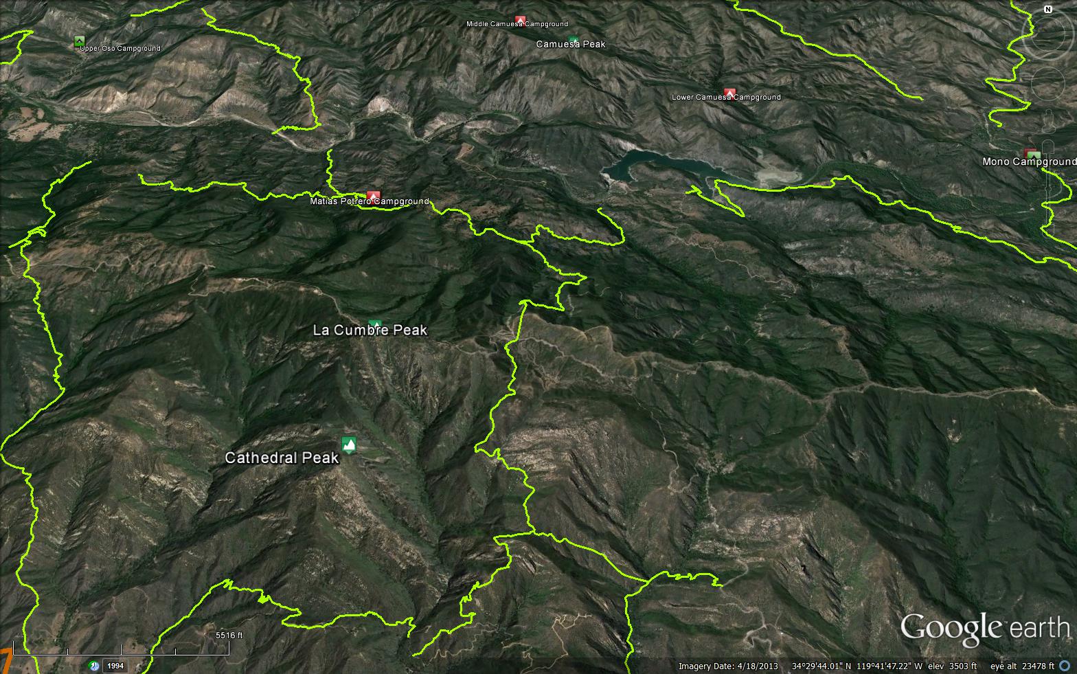
Chaparral, pools, and scenic views. Although there is no water and very little shade because it does not follow a prominent canyon or creek, it does afford spectacular views as it rises to the east of La Cumbre Peak. La Cumbre Peak is one mile from the trail head on East Camino Cielo. The East Camino Cielo trail head is not signed and is near a private homestead near the intersection of Gibraltar Road and East Camino Cielo. Access to the Santa Barbara Botanical Gardens near the bottom of the trail. Parking at the end of Tunnel Road is limited. You may have to hike some distance just to get to the trail head. Directions: The trail starts at the end of Tunnel Road. From Santa Barbara, take Foothill Road (Hwy 192) turn north on Mission Canyon Road toward to the Santa Barbara Botanical Gardens. Turn left on Tunnel Road before the Santa Barbara Botanical Gardens and park near the end of Tunnel Road.
The trailhead begins three-fourths mile beyond the end of Tunnel Road. Walk up the paved road, which continues steadily uphill. A hundred yards before Mission Tunnel the road turns sharply to the left and then curves past the West Fork of Mission Creek. If you look carefully beneath and to the right of the bridge you can see the tunnel.
The Tunnel trailhead begins a bit past Mission Tunnel. Fifty yards after the paved road ends (marked by a California Riding and Hiking trail sign) Tunnel Trail begins. To hike up it turn right. You will find the next half hour or so of hiking a challenge to the legs and your lungs.
Tunnel Trail proper passes through the four geologic formations of the Eocene epoch on its three-and-a-half mile length. At the trailhead Coldwater Sandstone predominates and the steeply-tilted slabs of this stone are what make this section such an effort.
The trail switches back and forth through rocky outcroppings of this rock, finally heading straight up the ridgeline separating the two main forks of Mission Creek. Views across the west fork canyon to Cathedral and La Cumbre peaks help soften the effort. In three-quarters mile the path turns right, heads up a rocky section fortified with railroad ties and around a large knoll that marks the end of this formation. A large peace symbol painted on the face of the cliff in the 1960s will provide notice you are about almost at the end of the tough hiking. I have often wondered who painted this 30’ high sign and just how they were able to get there to do it. Perhaps one of you might know.
There is one last steep climb then suddenly you round a corner and Mission Falls comes into view, a half-mile across the canyon. Rarely does water flow over its wide lip but it is the perfect place for a lunch stop. From here it is 20 minutes of very easy hiking around the upper end of the canyon to the falls.
If you look closely on the right you will spy a small, almost unnoticeable path leading up to the right. This off-trail route will take you directly up and over a thin ridgeline on which the peace symbol is painted. It is a scramble getting up and over the ridge, but the views are spectacular, there are numerous perches upon which to spend a bit of time, and most importantly it will take you across and down to the power lines, allowing you to make a loop out of your hike up Tunnel Trail. I often head up to the falls for lunch, drop back down to this point and then make my way across the ridge and back down via the power line road.
Continuing up Tunnel Trail on your way to the falls you will encounter a large saddle where a second geological formation is encountered—the easily weathered Cozy Dell Shale. Here you will find a connector trail leading down into the upper end of Rattlesnake Canyon.
A quarter mile beyond the connector trail large walls of tawny sandstone begin to appear, marking the end of the shale and the beginning of a third layer of rock, the rugged and highly scenic crags of Matilija Sandstone. A half mile farther along, look for the short path leading over to the falls. There you’ll find a sandstone bench marking the upper edge of the 200-foot-high Mission Falls. In springtime, with the creek flowing at its maximum, the spot is an ideal sunbathing and picnicking area. The view is breathtaking. It is also a wonderful place to view the sunset, but if you stay late be sure to bring a flashlight along for the trip back to the car.
After crossing the creek, the trail wanders for a half mile through the sandstone. Then, as the canyon narrows, you enter the fourth layer, the Juncal Formation, a shale which weathers readily to form clay hills. After this, the trail then meanders back and forth around small rounded knolls formed by the easily weathered rock to a saddle at East Camino Cielo known as Angostura Pass. La Cumbre Peak is an additional three-quarters mile (and 600’ of elevation gain) to the west on the paved road.
Hard core hikers will make it all the way up to the top of La Cumbre Peak. Those who are just a little bit crazy make the return trip via Cathedral Peak. The route down is off-trail and requires quite a bit of effort along the way but at day’s end, savoring the magnificence of what you have accomplished, you will be well pleased with yourself. A caution: this is hard core. Make sure you allow yourself plenty of time to make it all the way down. The Cathedral ridgeline is not where you want to be after dark.
Ray Ford - http://www.sboutdoors.com/tunnel-trail.html


 Tunnel Trail Survey - 01-06-2026 - by Anonymous Surveyor
| Link: | Tunnel Trail |
| Date: | 01-06-2026 |
| Surveyor Name: | Anonymous Surveyor |
| Trail description: | North Tunnel Trail remains closed due to 2023 storm damage. The upper portion of North Tunnel trail to the junction
with Matias trail is in good shape - may need a haircut in
the spring, but it's fine. From there to Gibraltar dam it is
in less good shape - there are a few slides through the
section under the power lines and some trees down. |
| Mode of transport: | Hike |
| Trail condition: | Needs some work |
| Images: | |
Tunnel Trail Survey - 04-27-2021 - by Los Padres Forest Association| Link: | Tunnel Trail |
| Date: | 04-27-2021 |
| Surveyor Name: | Los Padres Forest Association |
| Trail description: | The LPFA worked along with a SCA Trail Crew for two weeks on the Tunnel Trail in spring 2021 clearing brush, removing downed trees and repairing larger tread issues. Most of the work was focused on lower Tunnel between the end of the road / junction with Jesusita and the Tunnel Connector Trail. The trail is almost always in great shape but this additional time spent allowed us to hit some of the problem areas that might not normally be worked and brush the trail out to full FS standards. Enjoy..... |
| Mode of transport: | Array |
| Trail condition: | Good shape and easy to follow |
Tunnel Trail Survey - 03-11-2021 - by Anonymous Surveyor| Link: | Tunnel Trail |
| Date: | 03-11-2021 |
| Surveyor Name: | Anonymous Surveyor |
| Trail description: | Found a series of small arrows spray painted on rocks around the power lines. Absolutely unnecessary as the trail is wide open and followable. Not sure if hooligans or Edison’s contractors are directionally challenged |
| Mode of transport: | Hike |
| Trail condition: | Good shape and easy to follow |
Tunnel Trail Survey - 01-31-2019 - by Anonymous Surveyor| Link: | Tunnel Trail |
| Date: | 01-31-2019 |
| Surveyor Name: | Anonymous Surveyor |
| Trail description: | No problems on the trail even with rain in the morning. Mission Falls had plenty of water, and the creek crossing was deep but not too difficult. |
| Mode of transport: | Hike |
| Trail condition: | Good shape and easy to follow |
Tunnel Trail Survey - 01-04-2019 - by Los Padres Forest Assocation| Link: | Tunnel Trail |
| Date: | 01-04-2019 |
| Surveyor Name: | Los Padres Forest Assocation |
| Trail description: | Tunnel is a challenging, but rewarding hike. Great views and rock formations. There is significant rutting on the tunnel connector. The upper portion of the trail contains a number of failing waterbars with exposed rebar. Mountain bikers should be cautious when crossing these structures. There are minor ruts and silted in drainages as you climb higher. There are also a few narrow sections with failed cribbing that will need to be repaired. Overall, there is more right with the trail than there is wrong! Like most of the Santa Barbara froncountry trails, Tunnel will need constant attention to keep water off and keep the brush under control. Happy Hiking! |
| Mode of transport: | Hike |
| Trail condition: | Needs some work |
| Condition details: | Easily passable, but will need work on water control and ruts. |
| Images: | Some rutting caused by drains that are silted in. Waterbar without purpose :( Scary exposed posts. Something to look out for especially if you are on a bike. Ruts on the connector |
Tunnel Trail Survey - 01-20-2018 - by Erin C| Link: | Tunnel Trail |
| Date: | 01-20-2018 |
| Surveyor Name: | Erin C |
| Trail description: | Rode up Gibraltar and hike-a-biked down Tunnel Trail. The trail has a few flowy and rideable sections, but it is really more enjoyable on foot than on a bike. I am sure the hardcore downhiller MTBers love this trail, but it is way too technical for a typical XC mountain bike. It appears that some people have been doing a lot of brushing work recently on the trail. There is not much work to do on this trial. It is in very good shape.  |
| Mode of transport: | Bicycle |
| Trail condition: | Good shape and easy to follow |
| Images: | |
Tunnel Trail Survey - 09-30-2017 - by Los Padres Forest Association| Link: | Tunnel Trail |
| Date: | 09-30-2017 |
| Surveyor Name: | Los Padres Forest Association |
| Trail description: | ValHikes account of working on the Tunnel Trail as part of National Public Lands Day 2017. Thanks go out to Val and all the other trail workers. THANK YOU! http://valhikes.blogspot.com/2017/09/tunnel-trail-work.html?utm_source=feedburner&utm_medium=email&utm_campaign=Feed%3A+MomentsInDirtAndInk+%28Moments+in+Dirt+and+Ink%29 |
| Mode of transport: | Hike |
| Trail condition: | Good shape and easy to follow |
Tunnel Trail Survey - 04-01-2017 - by Valerie Norton| Link: | Tunnel Trail |
| Date: | 04-01-2017 |
| Surveyor Name: | Valerie Norton |
| Trail description: | This is for the north part of the trail that is shown in the track but not covered in the detailed (and wrong: the Rattlesnake Connector is along that 20 minutes of easy between spotting the falls and being at the falls) description and not shown in the elevation profile. Â So here is what it is like if you continue over the top and down the north side of the mountains: Thin and getting thinner as the brush grows in. Â Currently there is usually about a foot of clearance with brush often crossing. Â One section is full of bayonets that cannot be completely avoided. Â The tread is slanting more and more. Â One spot is falling away, but not yet impossible to pass, but the brush above pushing people off the side does not help. Â Unlike the front country stuff, this is a tread problem that can be fixed. It needs a sign at the top. Currently the only marking is a cairn. |
| Mode of transport: | Hike |
| Trail condition: | Needs some work |
| Condition details: | intense need of brushing, yucca removal, tread recovery |
Tunnel Trail Survey - 02-08-2017 - by Gabriel Lockwood| Link: | Tunnel Trail |
| Date: | 02-08-2017 |
| Surveyor Name: | Gabriel Lockwood |
| Trail description: | There is a small downed tree (5-6" thick) on Tunnel Trail between the Rattlesnake Connector and Angostura Pass, closer to the Rattlesnake Connector trail. Other than that the trail seemed in good shape. That said, I finished the last two miles heading uphill as the sun set and darkness fell, so I may have missed something. There was definitely some water and ruts on the trail from water runoff. |
| Mode of transport: | Hike |
| Trail condition: | Needs some work |
| Condition details: | Downed tree |
| Images: | Downed tree Pano Sunset |
Tunnel Trail Survey - 09-15-2016 - by Valerie Norton| Link: | Tunnel Trail |
| Date: | 09-15-2016 |
| Surveyor Name: | Valerie Norton |
| Trail description: | We hiked down the back side from Gibraltar Road to the dam for the Wednesday night hike. To say it is getting a little long on the sides would be an understatement, it needs a good cutting. At first, the only real problem is the level of slick bay leaves, but it gets worse. Oak stretches out over the trail at common human height all over the place. One spot is an absolute gauntlet of yucca spikes. Lower down, poison oak is taking over. As the trail turns north at the bottom, there is an oak across it. Â Below the oak, there are a number of smaller trees (under 1 foot) that have come down on the trail. These are found especially at the creek crossings. Tread is getting soft at the top and could use some rocks in a couple washes. Coming in around the top of Devils Canyon after the Matias junction, the tread needs a lot of work. |
| Mode of transport: | Hike |
| Trail condition: | Needs some work |
| Condition details: | back side: trees down, vegetation is getting difficult to pass in spots |
Tunnel Trail Survey - 05-24-2015 - by Anonymous Surveyor| Link: | Tunnel Trail |
| Date: | 05-24-2015 |
| Surveyor Name: | Anonymous Surveyor |
| Trail description: | Large tree across the trail down near the bottom, about the last two miles before the dam, a ton of poison oak overgrown on the trail, can't get around it. Beautiful trail but needs to be cleared. |
| Mode of transport: | Hike |
| Trail condition: | Needs some work |
| Condition details: | Needs clearing |
 Survey / Report Form - Please click this box to open the form.