 Use Marker Groups
 Wolf 2002
Piru 2003
Day 2006
Zaca 2007
Gap 2008
La Brea 2009

| Date | Surveyor | Water Report |
| 07-07-2023 | Anonymous Surveyor | Dry |
| 03-18-2023 | Anonymous Surveyor | Dry |
| 03-23-2021 | bardley | Dry |
| 02-02-2020 | Antonio Calderon | Dry |
This camp and peak is a high point on the Nordhoff Ridge which is the range of mountains north of the town of Ojai. Charles Nordhoff, a featured writer for eastern papers, wrote in glowing terms of the area and the town when it was laid out in 1874. It was named after him in 1874 but in 1917 the town name was changed to Ojai. The U. S. Geological Survey named the peak in 1903 after the nearby town of the same name. The mountains are composed of Focene Age with formations named Juncal shale, Matilija sandstone, Cozy Dell shale and Coldwater sandstone. All of these formations are all what the geologists calI "overturned" meaning they are upside down with the younger rocks on the bottom and the old rocks on top.
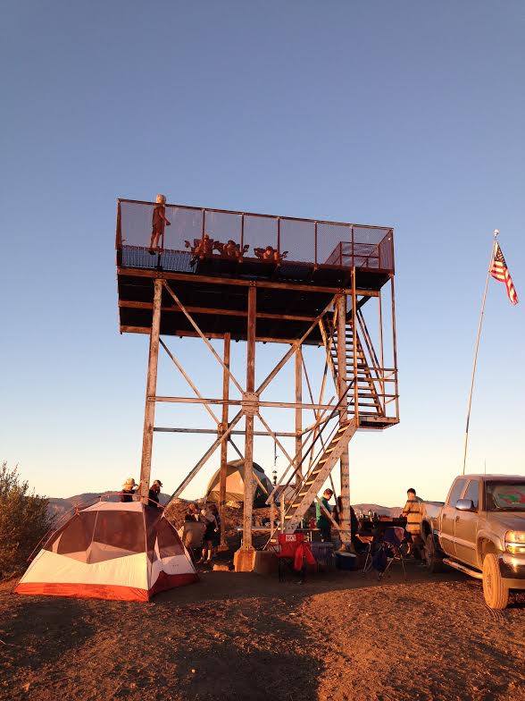
A lookout tower was constructed in the 1930's and abandoned in the late 1960's or early 1970's. The cabin was removed so that now just the tower and a platform remain. The tower at camp provides an excellent spot from which to view the Upper and Lower Ojai Valley and all the way out to the ocean and beyond or north to the Sespe Valley and Pine Mountain.


 Tower Camp Survey - 07-07-2023 - by Anonymous Surveyor
| Link: | Tower Camp |
| Date: | 07-07-2023 |
| Surveyor Name: | Anonymous Surveyor |
| Camp Description: | Hot and dry with a little shade from the tower. Lots of flies in the area. There's an established fire ring, a picnic table, and lots of flat open space. Didn't camp but would be a good space for a group because of the flat space. |
| Water Source: | Dry |
| Water Source Details: | No source of water here |
| Weather Conditions: | Hot and dry, very little shade from the tower. |
| Images: | |
Tower Camp Survey - 03-18-2023 - by Anonymous Surveyor| Link: | Tower Camp |
| Date: | 03-18-2023 |
| Surveyor Name: | Anonymous Surveyor |
| Camp Description: | Area is in good condition. A few pieces of firewood are available but are wet from the rain. Wouldn't burn. 3 glass bottles left in the firepit. Hauled in water from Gridley trail. Table is in good condition. No shovel. Shovel is by the Gridley trail sign. No snow. |
| Water Source: | Dry |
| Water Source Details: | |
| Weather Conditions: |
Tower Camp Survey - 03-23-2021 - by bardley| Link: | Tower Camp |
| Date: | 03-23-2021 |
| Surveyor Name: | bardley |
| Camp Description: | There’s a fire ring half filled with ashes, debris and various size rocks and small boulders. The picnic table is in great shape. Vandals continue to remove by force the mesh safety screening along the sides of the observation tower. Be mindful if you have small children. The views are fantastic both out to the Channel Islands and back to the Pine Mountain massif. Topatopa Bluff commands the eastern view and Old Man Mountain is nearby to the west. An excellent midpoint of a day’s adventure. |
| Water Source: | Dry |
| Water Source Details: | There is no water here unless it rains. Then you have to catch it. |
| Weather Conditions: |
Tower Camp Survey - 02-02-2020 - by Antonio Calderon| Link: | Tower Camp |
| Date: | 02-02-2020 |
| Surveyor Name: | Antonio Calderon |
| Camp Description: | Hiked up to Nordhoff peak from the Pratt trail. Camp In  good condition with  fire ring and table. Beautiful  views all around. |
| Water Source: | Dry |
| Water Source Details: | |
| Weather Conditions: | Low 70s sunny, windy |
| Images: | |
 Survey / Report Form