 Use Marker Groups
 Wolf 2002
Piru 2003
Day 2006
Zaca 2007
Gap 2008
La Brea 2009


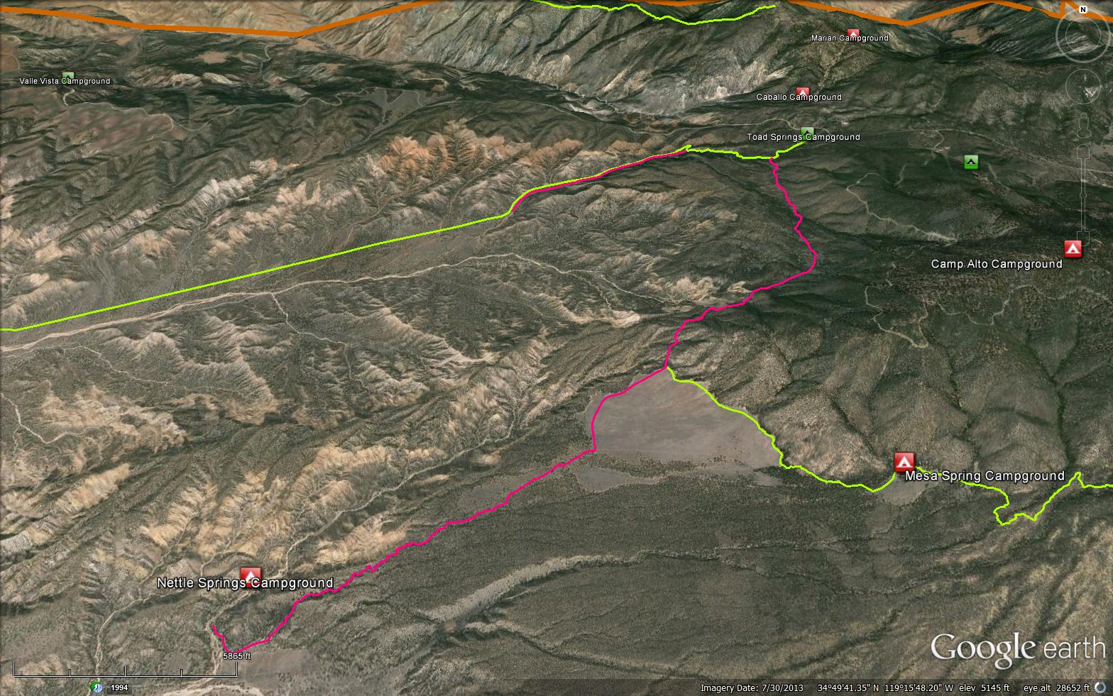
 Toad Springs OHV Trail Survey - 11-30-2024 - by Molly T.
 | Link: | Toad Springs OHV Trail |
| Date: | 11-30-2024 |
| Surveyor Name: | Molly T. |
| Trail description: | Ran this trail from the Toad Springs side to San Emigdio Mesa Springs Trail junction and then up to Mesa Springs Camp. Wasn't sure what to expect with only old reports, but this trail is being maintained and was in great shape. Some of the tread is a bit narrow, but otherwise clear and easy to follow. There seems to be a reroute around the slide that I had read about because I did not have to cross a slide. Super quiet out there, didn't see anyone until just before Mesa Springs Camp! |
| Mode of transport: | Array |
| Trail condition: | Good shape and easy to follow |
| Images: | Clear trail, easy to follow This might be where the reroute starts. |
Toad Springs OHV Trail Survey - 08-13-2024 - by Anonymous Surveyor| Link: | Toad Springs OHV Trail |
| Date: | 08-13-2024 |
| Surveyor Name: | Anonymous Surveyor |
| Trail description: | Contrary to what some have posted here, Toad Springs is designated an OHV trail, not a hiking only trail. Verbage such as illegal, and trespass have no place here as this trail was temporarily closed due to a landslide and has not reopened since. It would take very little money and effort to competently reroute around the slide and a beautifull trail that links Quatal and Apache could be enjoyed by all. Please think a little deeper and do not fall for the old Forest Service trick of "temporarily closing" a trail only to then find a reason that it should be permanently shuttered or reclassified. Cases in point include the Stonehouse Trail, Sheep Creek, Kerry Canyon, Lockwood Creek, Hardluck, and many more. |
| Mode of transport: | Bicycle |
| Trail condition: | Needs some work |
| Condition details: | An OHV Trail Worth Saving |
Toad Springs OHV Trail Survey - 09-29-2023 - by Drew Helms| Link: | Toad Springs OHV Trail |
| Date: | 09-29-2023 |
| Surveyor Name: | Drew Helms |
| Trail description: | I hiked this trail from Nettle Springs Camp to the San Emigdio Mesa Springs Trail junction. There is some irrigation pipe in the first mile of the trail (34.79937, -119.28952). This trail is easy to follow (mostly), although not always in the designated location and not for altogether good reasons. This trail is clearly being maintained by a freelance crew of the two-wheeled variety. They have cut fallen trees out of the trail, but left large widow-maker branches (34.80277, -119.286). At other points, rather than clear the trail they have cut alternative paths, often cutting direct paths across switchbacks with oddly steep grades that are suitable for dirt bikes, but not so much for legs and feet. They have a log book at the junction taking credit for their work and, of course, claiming counter-factually that the trail is not part of the wilderness area. The views are amazing when you come out of the woods onto the mesa from this southern approach. It is a good trail, connecting to good water at Mesa Spring, and it would be a shame to abandon this southern section of the trail. The log book claims that these enthusiastic riders have cut an alternative path around the slide area north of the junction. I did not investigate, but would be surprised if it was professionally done. I highly doubt they have installed crib walls or maintained trail profiles appropriate for foot and hoof, but it is probably passable. |
| Mode of transport: | Hike |
| Trail condition: | Good shape and easy to follow |
| Images: | 34.79937, -119.28952 34.80277, -119.286 Old junction sign needs work "volunteer"/visitor log book Looking back down the trail to the southwest from 34.82304, -119.25493 |
Toad Springs OHV Trail Survey - 05-09-2020 - by Anonymous Surveyor| Link: | Toad Springs OHV Trail |
| Date: | 05-09-2020 |
| Surveyor Name: | Anonymous Surveyor |
| Trail description: | did some trail maintenance on Toad springs trail. This is a great trail, needs to be re-routed around the washed out section , which would probably require about 1/4 to1/2 mile of trail. San emigdio mesa was full of poppies. |
| Mode of transport: | O.H.V. |
| Trail condition: | Needs some work |
| Condition details: | Toad springs trail from nettle springs |
| Images: | |
Toad Springs OHV Trail Survey - 11-24-2017 - by Craig R. Carey| Link: | Toad Springs OHV Trail |
| Date: | 11-24-2017 |
| Surveyor Name: | Craig R. Carey |
| Trail description: | This OHV route has been closed (abandoned) for what seems like ages now, but still a nice walk from Nettle Spring to the mesa. The water at the upper Nettle Spring (~34.800998, -119.288481) was still flowing along the trail. The route has numerous trees down, but it's easy enough to just walk around them. Open country. Route is easy enough to follow from the light foot traffic and occasional OHV trespass. |
| Mode of transport: | Hike |
| Trail condition: | Needs some work |
| Condition details: | Another beautiful day! |
| Images: | |
Toad Springs OHV Trail Survey - 10-03-2015 - by RSO McCabe| Link: | Toad Springs OHV Trail |
| Date: | 10-03-2015 |
| Surveyor Name: | RSO McCabe |
| Trail description: | The trail is in good condition till the old slide. There is a big oak tree down across the trail, it is passable by hikers but not stock. There is an old wooden trail sign marking the turn up and over the slide area. The trail is marked by too many ducks. Got to the junction and headed for Mesa Springs. Was close but running out of daylight and trail is very difficult to find at the turn off the mesa. |
| Mode of transport: | Hike |
| Trail condition: | Needs some work |
 Survey / Report Form - Please click this box to open the form.