 Use Marker Groups
 Wolf 2002
Piru 2003
Day 2006
Zaca 2007
Gap 2008
La Brea 2009

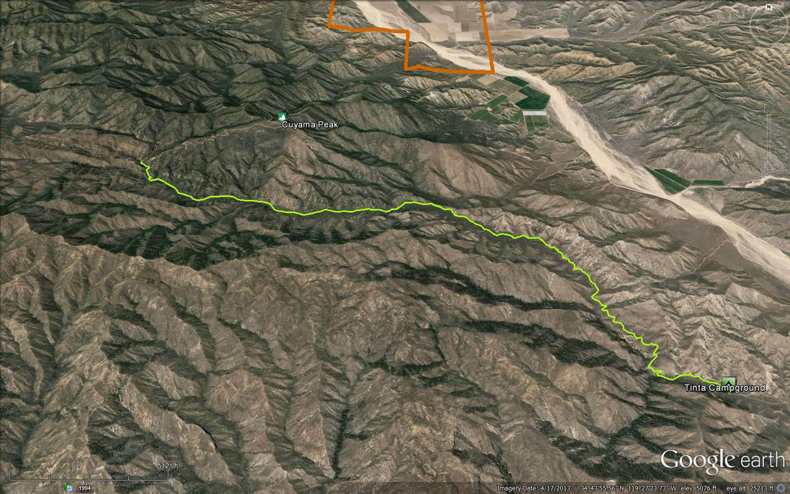
Wandering motorcycle trail up a canyon. Connects Tinta campground with West Dry Canyon Road.


 Tinta OHV Trail Survey - 01-09-2020 - by Valerie Norton
| Link: | Tinta OHV Trail |
| Date: | 01-09-2020 |
| Surveyor Name: | Valerie Norton |
| Trail description: | I hiked up to Brubaker, then started up the ridge to Cuyama Peak. I returned along the whole length of the trail. The tread was generally solid. I saw one spot where a switchback is going missing to be replaced by a rather steep trail. There's a log that is clearly giving the motorcycles a bit of trouble, but was an easy step for me. There's some tall white thorn that is bending in to grab the opened up space from the brushing. It goes 100 feet or so a little short of Brubaker. Coming down, I found the upper section has been thrashed some recent high winds at some point. There's a few blow downs. None of it is blocking, even to motorcycles, but it is a bit annoying to get through in spots. Otherwise, it looks like there was a narrow bulldozer through making the trail very clear indeed. |
| Mode of transport: | Hike |
| Trail condition: | Good shape and easy to follow |
Tinta OHV Trail Survey - 12-07-2019 - by Anonymous Surveyor| Link: | Tinta OHV Trail |
| Date: | 12-07-2019 |
| Surveyor Name: | Anonymous Surveyor |
| Trail description: | Good treadwork done recently from dry canyon rd to brubaker canyon rd. From brubaker canyon to tinta campground needs work. |
| Mode of transport: | O.H.V. |
| Trail condition: | Needs some work |
| Condition details: | Tinta trail from tinta campground to cuyama peak |
| Images: | Tinta campground trailhead "Helipad" @brubaker junction Trail overgrown before brubaker Looking southeast down tinta canyon trail Water in creek. |
Tinta OHV Trail Survey - 04-14-2019 - by Los Padres Forest Association| Link: | Tinta OHV Trail |
| Date: | 04-14-2019 |
| Surveyor Name: | Los Padres Forest Association |
| Trail description: | The LPFA in conjunction with VCMC, MPRP, SCA and NFWF organized a week-long trail project April 8-14, 2019 along the Tinta Trail. The focus of this work was to complete the final 2miles of brushing from Upper Tinta Camp down to Brubaker. Over the course of the past 2-3 years we've now finished brushing along the Tinta Trail. In addition, Ventura County Motorcycle Club has also completed tread work along the upper portion of the trail from Dry Canyon to Brubaker. There was water along the extent of Tinta Canyon. Upper Tinta Camp was a wonderful home-base for our workers as well. This is a good time to ride, bike or hike Tinta Trail. Go check it out...... |
| Mode of transport: | Array |
| Trail condition: | Good shape and easy to follow |
| Images: | How about that before and after?!!?? LPFA Volunteers hard at work..... |
Tinta OHV Trail Survey - 05-07-2019 - by Diane Soini| Link: | Tinta OHV Trail |
| Date: | 05-07-2019 |
| Surveyor Name: | Diane Soini |
| Trail description: | Trail is in good shape. There was water in the creek. It's a pretty trail at the upper portion near where it connects to Dry Canyon Road and kind of boring and wide toward the bottom portion. The trail camp is a big disappointment. No shade, nothing rewarding about it at all. |
| Mode of transport: | Hike |
| Trail condition: | Good shape and easy to follow |
Tinta OHV Trail Survey - 10-24-2018 - by Los Padres Forest Assocation| Link: | Tinta OHV Trail |
| Date: | 10-24-2018 |
| Surveyor Name: | Los Padres Forest Assocation |
| Trail description: | Brushing was completed along the middle section of Tinta Trail. ACE crew completed 2.25 miles of brushing and removed 2 downed trees. 2 miles of brushy trail conditions remain in the middle section beyond the old road bed/ gate. Severe rutting remains in sparse sections along the trail.  |
| Mode of transport: | Hike |
| Trail condition: | Good shape and easy to follow |
| Images: | Wide open! A lot of brushing... |
Tinta OHV Trail Survey - 11-22-2017 - by Los Padres Forest Association| Link: | Tinta OHV Trail |
| Date: | 11-22-2017 |
| Surveyor Name: | Los Padres Forest Association |
| Trail description: | The LPFA spent two weeks working the Tinta Trail as part of a NFWF trails grant. We cleared the top 1.6 miles from the upper trailhead down past Upper Tinta Camp. The trail is extremely brushy below the 1.6 mile mark with narrow tread, gullies, washouts and ruts. We're hoping to get back out there soon and finish it up. More details at the link below. http://arcg.is/2BeAXA3 |
| Mode of transport: | Hike |
| Trail condition: | Needs some work |
| Images: | This is what the brushy sections look like. This is what the cleared top 1.6 miles looks like. This is what Upper Tinta Camp looks like. |
Tinta OHV Trail Survey - 04-14-2017 - by Mike Maki| Link: | Tinta OHV Trail |
| Date: | 04-14-2017 |
| Surveyor Name: | Mike Maki |
| Trail description: | First three miles from the locked gate at Hwy 33 freshly graded to Tinta Camp. Still some water in Cuyama River. Lots of water in Tinta Creek. The trail past Tinta Camp is in good shape. Some areas a little brushy and some a little rutted. No poison oak! Easy to follow. I follow one set of motorcycle tracks all the way to Cuyama Peak. Water still flowing where the trail ends at Dry Canyon Road (8N19). Pics from a hike up Tinta to Cuyama Pk, down Dry Canyon, and out Santa Barbara Cyn. |
| Mode of transport: | Hike |
| Trail condition: | Good shape and easy to follow |
| Images: | One of several Arizona crossings on freshly graded Tinta Trail Roads end at trail start at Tinta Camp Typical trail condition (good!) and water in Tinta Creek Tinta Creek about 5 miles in Trails end at Dry Canyon Road |
Tinta OHV Trail Survey - 03-30-2015 - by Los Padres Forest Association| Link: | Tinta OHV Trail |
| Date: | 03-30-2015 |
| Surveyor Name: | Los Padres Forest Association |
| Trail description: | UTMC continued their onslaught on the fallen trees within the Mt Pinos Ranger District. Â If you were a tree blocking a trail in the MPRD, be worried, real worried! This time they logged 15 trees off the Tinta Trail and 10 leaners were felled from next to the trail. |
| Mode of transport: | Stock |
| Trail condition: | Needs some work |
 Survey / Report Form - Please click this box to open the form.