 Use Marker Groups
 Wolf 2002
Piru 2003
Day 2006
Zaca 2007
Gap 2008
La Brea 2009

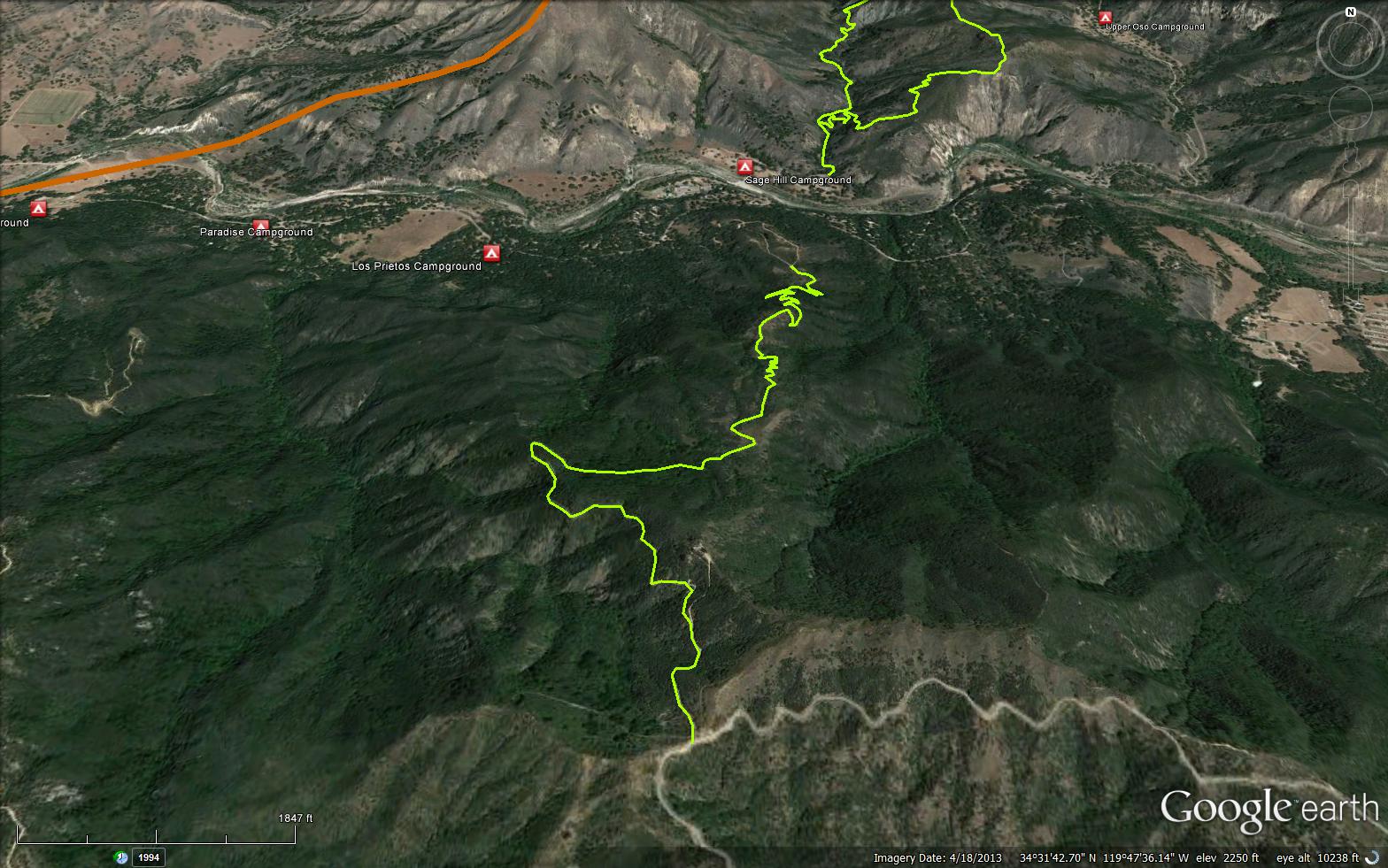
The first half mile of the Snyder Trail actually follows a dirt road which leads to a water tank—the Forest Service water supply. Beyond this it rises up through chamise chaparral to a shaded oak section which is quite unexpected. Switchbacks up through this allow you to enjoy an extended section of this, along with ferns, California bay, and other plants that prosper in the shade of the oak canopy.
In a mile the trail opens to grassy slopes, an environment that occurs here because of its proximity to the Santa Ynez Fault. The ground along the fault has been pulverized into a clay that grasses thrive on. At the two mile point from Paradise Road the trail ends and Knapp’s road begins. Heading to the left takes you down into Lewis Canyon. Though you’ll find old rusty pipes from the days when the Knapp Bathhouse was located here and two waterfalls, erosion and the intrusion of the chaparral makes it almost impossible to get to them.
The route up to the Castle leads to the right. It is another 1.25 miles to the ruins but the road is open and the climb gradual, making this part of the hike thoroughly pleasurable.
Ray Ford - www.SBOutdoors.com


 Snyder Trail Survey - 03-25-2023 - by Los Padres Forest Association
| Link: | Snyder Trail |
| Date: | 03-25-2023 |
| Surveyor Name: | Los Padres Forest Association |
| Trail description: | The LPFA partnered with the Forest Service and local scout troop #37 to restore the lower portion of the Snyder Trail. Most of the work was fixing busted erosion control and drains along the trail. Fun was had by all! We are always looking for scout troops to help with projects like these. Email us at VOLUNTEER@LPForest.org if you know a scout troop who might want to join in on the fun. |
| Mode of transport: | Array |
| Trail condition: | Needs some work |
Snyder Trail Survey - 05-25-2020 - by Los Padres Forest Association| Link: | Snyder Trail |
| Date: | 05-25-2020 |
| Surveyor Name: | Los Padres Forest Association |
| Trail description: | In addition to logging current trail conditions, HLP is also setup to record the history and changes within the Los Padres. Here is a great article about Knapp's Castle, located near the top of Snyder: |
| Mode of transport: | Hike |
| Trail condition: | Good shape and easy to follow |
Snyder Trail Survey - 04-10-2018 - by Los Padres Forest Assocation| Link: | Snyder Trail |
| Date: | 04-10-2018 |
| Surveyor Name: | Los Padres Forest Assocation |
| Trail description: | SBMTV (Santa Barbara Mountain bike Trail Volunteers) worked on water control along Snyder trail in April 2018. Trail is in good shape for bikes and hikers alike. Thank you volunteers! Happy riding. Read more here: |
| Mode of transport: | Bicycle |
| Trail condition: | Good shape and easy to follow |
Snyder Trail Survey - 02-19-2017 - by Michel Giroux| Link: | Snyder Trail |
| Date: | 02-19-2017 |
| Surveyor Name: | Michel Giroux |
| Trail description: | The trail sustained some damage from the recent storm. Two trees are blocking the trail and I removed a lot of branches that fell into it. The water breaks were not enough to retain all that water and it created ruts in a lot of places. There is also a few landslides, mostly minor besides one that might be dangerous for mountain bikers. See pictures. |
| Mode of transport: | Hike |
| Trail condition: | Needs some work |
| Images: | 34.541268,-119.791119 34.536769,-119.789044 34.529484,-119.791155 |
Snyder Trail Survey - 02-08-2015 - by FP| Link: | Snyder Trail |
| Date: | 02-08-2015 |
| Surveyor Name: | FP |
| Trail description: | This trail is very popular with mountain bikers on weekends. For that reason, it's not that enjoyable as a hiking trail. There are better options if you want to hike from Camino Cielo to Paradise Rd. The Fremont trail and the Arroyo Burro Trail are much nicer and with no bikers. |
| Mode of transport: | Hike |
| Trail condition: | Good shape and easy to follow |
 Survey / Report Form - Please click this box to open the form.