 Use Marker Groups
 Wolf 2002
Piru 2003
Day 2006
Zaca 2007
Gap 2008
La Brea 2009

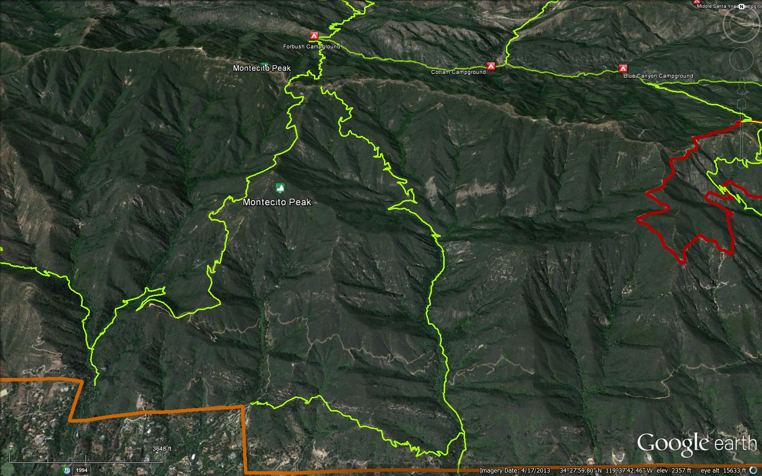
The trail begins just before the locked gate crossing on San Ysidro Creek. A small sign marked with the San Ysidro Ranch brand is fastened to a nearby oak tree. The path continues along the driveway for a hundred yards, then winds around the rear of a house and up onto a paved road. Follow this up to a wide dirt road that has a chain link gate partially across it and head up it. After a half mile you will come to a thick sequence of Coldwater Sandstone forming a deep “V”, a gateway to the inner canyon beyond.
Just before this “V” several connector trails lead off to the east and the west, providing access to the canyons on either side. The Old Pueblo Trail is to the right, leading east, sharply uphill, and over a ridgeline to upper Park Lane and the Buena Vista Trail. The McMenemy Trail is not too far beyond. This trail crosses San Ysidro Creek and leads up onto a grassy plateau above the San Ysidro Guest Ranch.
To reach the upper end of San Ysidro Canyon follow the dirt road through the narrow “V” created by the Coldwater Sandstone. Look for a large sandstone wall on your left. This is a popular rock-climbing area.
The road continues bobbing up and down along the right side of the canyon for another third mile through very pleasant forests of oak and sycamore. Occasionally there is an opening from which you can catch a glimpse of the upper canyon. The Buena Vista Catway is on the right. It turns sharply back to the right and is easy to miss.
Eventually the road turns left, crosses the creek, and heads up to Hot Springs Canyon. If you’ve gotten to the creek crossing this means you just missed the trail turnoff leading into the upper canyon. Look for the trail just before the road turns left.
The path wanders for a mile through canyon vegetation and oak woodland before heading up into the chaparral. This one mile section is the prettiest part of the canyon. The Cozy Dell Shale dominates, and the canyon is filled with small waterfalls, numerous pools, and many short paths leading down to picturesque spots for relaxing or picnicking.
As you continue on, the canyon narrows and steepens as the trail passes into the Matilija formation. Along one section you’ll find a pipe railing to aid the climb upward, though it is hardly needed. You might also follow the creek through the narrows if you are adventurous enough to brave the rock scrambling and occasional willow thickets. You won’t find it easy going but there are several waterfalls in the narrows which you can’t see from the trail which are very nice.
Eventually you will drop back down to the creek at a point where the canyon splits into an east and west fork. The trail crosses the creek and begins a steep uphill climb. This marks the beginning of the Juncal Formation, as well as the point at which you will no longer have access to water. You’ll need plenty if you plan to continue up to the crest.
The creek crossing is a favorite turn around spot for many hikers. If you‘d like to keep this a relaxing, cool, and moderately easy hike, stop here and explore each of the upper forks. You’ll discover the 80-foot waterfall not too far up the west fork. You might also try exploring the east fork. There is no trail, but the rock hopping is fun and the creek is very pretty.
If you are heading to the crest, the trail begins to climb immediately beyond the creek crossing. Several switchbacks provide 300’ of elevation gain, bringing you out on the side of the mountain and above the west fork of the creek. From here the trail contours above the west fork for three-fourths mile then switches back and forth up a prominent ridgeline. Hiking to the crest adds another two miles, but the effort of making it to the top is well worth it.
From Camino Cielo, the Cold Springs Trail is only a short distance to the west and it is tempting to make this a loop trip back down. This loop is one of my favorites. A good choice if you want to do the loop is to have a shuttle car at the Cold Springs trailhead to take you back to San Ysidro Canyon. That way you can enjoy a dip in the pools in lower Cold Springs.
To loop all the way back to the San Ysidro trailhead continue down the Cold Springs Trail to the catway and follow this east back into the upper canyon. Alternative routes down the Saddle Rock and McMenemy trails or Girard and McMenemy trails are also possible.


 San Ysidro Trail Survey - 11-28-2018 - by Los Padres Forest Assocation
| Link: | San Ysidro Trail |
| Date: | 11-28-2018 |
| Surveyor Name: | Los Padres Forest Assocation |
| Trail description: | Starting from June 2018 to November 2018, volunteers worked hard to reopen San Ysidro from the trailhead on Mountain Dr. to the waterfall (~2 miles). Debris, slides and missing sections have been repaired and are safely passable. Thanks Dave! NOTE: The trail above the waterfall is still damaged and unsafe for the average hiker. While it is open to the public, we do not recommend hiking the 2 miles above the waterfall to E. Camino especially in inclement weather. LPFA has performed emergency trail work on upper SY to keep water from eroding the trail, but there will be months of work ahead before the upper trail is stable and safe to hike. Photos courtesy of Dave Everett. |
| Mode of transport: | Hike |
| Trail condition: | Needs some work |
| Condition details: | Trail is in good shape from trailhead to the waterfall! |
| Images: | Breaking ground... Literally! Beautiful tread. Nice work! Long lost crib wall uncovered. The falls! |
San Ysidro Trail Survey - 04-15-2017 - by Los Padres Forest Association| Link: | San Ysidro Trail |
| Date: | 04-15-2017 |
| Surveyor Name: | Los Padres Forest Association |
| Trail description: | The Santa Barbara trail community ascended (and descended) on the San Ysidro Trail as part of California State Trails Day. Â Great work was done up and down the trail. Â Pictures are the proof: Photos by Dave Everett (Multi-Use Trails Coalition): https://photos.google.com/share/AF1QipMKbXorUTTT11aqTOpw0XWcQm5KICrKXWkBmDukQYmAg83KkRaEldC1km3xGBplTQ?key=UC1RRENHQTFmLVhVYkY0X19qNW5SVVUzcE02eTN3 Photos by Mike Tarpey (SBMTV): https://photos.google.com/share/AF1QipMD8wQCU3AiBr8lbBErfZDmOq8qE5oo6lJ8xz4wP03-AMqeHdNdP9OSeB0bGhj_yw?key=cDFDUmN3cE1zWkcyN0pNM2RXaTl2dTBMZm4xQzhR |
| Mode of transport: | Array |
| Trail condition: | Good shape and easy to follow |
San Ysidro Trail Survey - 12-25-2015 - by Aaron Songer| Link: | San Ysidro Trail |
| Date: | 12-25-2015 |
| Surveyor Name: | Aaron Songer |
| Trail description: | creek is lightly flowing, more flow further up canyon |
| Mode of transport: | Hike |
| Trail condition: | Good shape and easy to follow |
 Survey / Report Form - Please click this box to open the form.