 Use Marker Groups
 Wolf 2002
Piru 2003
Day 2006
Zaca 2007
Gap 2008
La Brea 2009

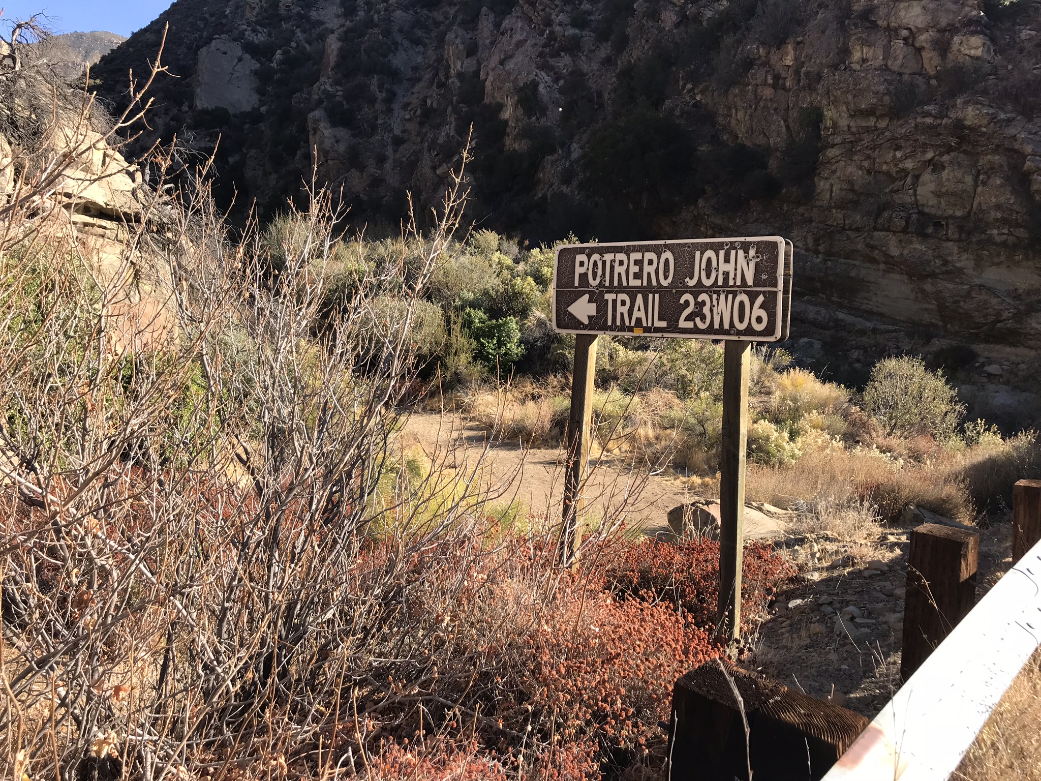
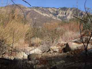
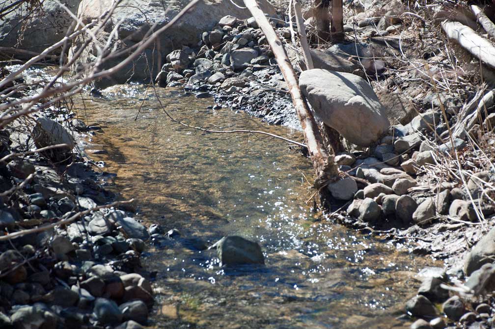
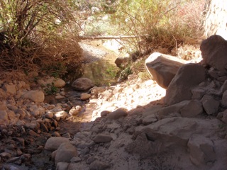
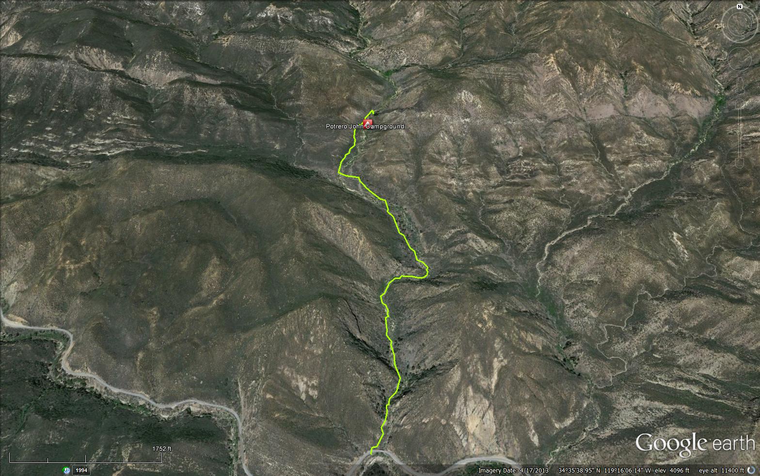
Take Highway 33 north of Ojai to the trailhead at mile marker 32.10. The trail is on the right hand side of the highway. This trail provides a beautiful day hike following a stream channel into the Sespe Wilderness. It has running water most of the year. The trail ends at Potrero John Camp, but it can be fun to explore the drainage beyond the camp. The camp and creek names were originally spelled "Jon" which was later anglicized to "'John". Named for John Power who was a man who lived in the area in the early 1900's. He used the area to pasture stock


.JPG)
.JPG)


 Potrero John Trail Survey - 07-26-2025 - by Los Padres Forest Association
| Link: | Potrero John Trail |
| Date: | 07-26-2025 |
| Surveyor Name: | Los Padres Forest Association |
| Trail description: | Dan McCaslin article about a recent hike he took up Potrero John Cyn: https://www.noozhawk.com/dan-mccaslin-potrero-john-trail-and-canyon-perfect-for-half-day-hike/ * Note: the Thomas Fire did not burn Potrero John |
| Mode of transport: | Hike |
| Trail condition: | Needs some work |
Potrero John Trail Survey - 05-14-2024 - by Dan W| Link: | Potrero John Trail |
| Date: | 05-14-2024 |
| Surveyor Name: | Dan W |
| Trail description: | Hiking this trail several times this spring, the planet are growing fast and overtaken the trail. Poison oak is encroaching on the trail in many spots. No downed trees across the trail for now. |
| Mode of transport: | Hike |
| Trail condition: | Needs some work |
| Condition details: | With all the rain this year the trail is getting overgrown fast |
Potrero John Trail Survey - 01-26-2024 - by bardley| Link: | Potrero John Trail |
| Date: | 01-26-2024 |
| Surveyor Name: | bardley |
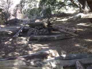
| Trail description: | Temps in the shade probably in the low-mid 60s, in the sun probably mid 70s. great day for a hike. no obstructions. water crossings can be made with dry feet. some not readily discernible due to washouts from recent rains. could use brushing in some areas. potrero john camp is wide open with many areas for tents. fire ring intact. box grill and grate present. the social trail to the waterfalls demands good navigational skills and major bushwhacking in numerous locations. trail washouts force hikers into the creek bed and onto creek islands. we turned back short of the falls due to time constraints. |
| Mode of transport: | Hike |
| Trail condition: | Needs some work |
| Condition details: | No obstructions |
Potrero John Trail Survey - 06-07-2022 - by Ari Songer| Link: | Potrero John Trail |
| Date: | 06-07-2022 |
| Surveyor Name: | Ari Songer |
| Trail description: | As a follow up to National Trails day, LPFA and 6 volunteers met at Potrero John Trailhead and hiked back to the camp. From there we worked on brushing toward the trailhead, clearing the thick willow section and trying our best to safely remove the encroaching poison oak. There is still more brushing to be done on the entire trail, but it is passable and easy to follow. We also cleared a downed tree and blocked a substantial social trail around the downed tree. There was still water in the creek and temps in the high 80's. |
| Mode of transport: | Hike |
| Trail condition: | Needs some work |
| Condition details: | LPFA Volunteer Project |
| Images: | Before After |
Potrero John Trail Survey - 06-01-2022 - by Dan Whelan | Link: | Potrero John Trail |
| Date: | 06-01-2022 |
| Surveyor Name: | Dan Whelan |
| Trail description: | Trail is easy to follow but quite overgrown in many spots. A downed tree in the meadow across the trail now has an established trail around it. The creek is dry in several spots but there is still plenty of flowing water at the campground. |
| Mode of transport: | Hike |
| Trail condition: | Needs some work |
| Images: | |
Potrero John Trail Survey - 01-25-2022 - by bardley| Link: | Potrero John Trail |
| Date: | 01-25-2022 |
| Surveyor Name: | bardley |
| Trail description: | The aforementioned trail-blocking trees were removed today by Mighty Mary and myself. The trail is now open for business. If you're looking for the camp, follow the sage advice from Craig R. Carey's Hiking and Backpacking Santa Barbara & Ventura 2nd Edition - "Follow the easy trail toward a solitary oak at the far end of the potrero, where you’ll find the spur trail (1.6 miles from the trailhead) leading across the creek to Potrero John Camp." emphasis mine. it is very easy to miss the turnoff. look for the solitary oak. |
| Mode of transport: | Hike |
| Trail condition: | Good shape and easy to follow |
| Images: | 1.19.2022 :: before 1.25.2022 :: after |
Potrero John Trail Survey - 01-15-2022 - by Scott Hathaway| Link: | Potrero John Trail |
| Date: | 01-15-2022 |
| Surveyor Name: | Scott Hathaway |
| Trail description: | The trail is in pretty good shape; however, there are a few fallen trees blocking the trail at different points. The water in the creeks is flowing nicely, but low enough to allow for easy rock hopping. The camp at the end of the trail was hard to identify. We saw a couple small campsite right along the river, but couldn’t find any set very far away from the water. |
| Mode of transport: | Hike |
| Trail condition: | Good shape and easy to follow |
Potrero John Trail Survey - 01-09-2021 - by Antonio Calderon| Link: | Potrero John Trail |
| Date: | 01-09-2021 |
| Surveyor Name: | Antonio Calderon |
| Mode of transport: | Hike |
| Trail condition: | Good shape and easy to follow |
| Images: | |
Potrero John Trail Survey - 12-12-2020 - by bardley| Link: | Potrero John Trail |
| Date: | 12-12-2020 |
| Surveyor Name: | bardley |
| Trail description: | the aforementioned hazard tree (leaner) was removed by a volunteer group of three. easy peasy - about 1100’ feet from the trailhead. they should all be this easy. |
| Mode of transport: | Hike |
| Trail condition: | Good shape and easy to follow |
Potrero John Trail Survey - 12-09-2020 - by Dan Whelan| Link: | Potrero John Trail |
| Date: | 12-09-2020 |
| Surveyor Name: | Dan Whelan |
| Trail description: | Trail is in great shape all the way. As I walked the trail hardly ever had vegetation touch me beside some low growing annuals and small shrubs. Water is flowing the entire length of the canyon. One large hazard tree across the trail, still partially standing as it is being held up by a live tree that is smaller then the dead tree. See photos |
| Mode of transport: | Hike |
| Trail condition: | Good shape and easy to follow |
| Images: | Leaning across the trail Hazard tree |
Potrero John Trail Survey - 03-09-2020 - by Los Padres Forest Association| Link: | Potrero John Trail |
| Date: | 03-09-2020 |
| Surveyor Name: | Los Padres Forest Association |
| Trail description: | As part of a Forest Service tick surveillance project, the ticks found on the Potrero John trail were negative for the presence of Borrelia species. |
| Mode of transport: | Hike |
| Trail condition: | Needs some work |
Potrero John Trail Survey - 06-21-2020 - by Jeremy Scarlett| Link: | Potrero John Trail |
| Date: | 06-21-2020 |
| Surveyor Name: | Jeremy Scarlett |
| Trail description: | Trail in good shape to the trail camp, but hemmed in with poison oak at quite a few spots. Wear pants and long sleeves. Up the canyon becomes a bit more of a pick your route the closer you get to the falls but still easy to follow. |
| Mode of transport: | Hike |
| Trail condition: | Good shape and easy to follow |
| Images: | Lower falls Upper falls |
Potrero John Trail Survey - 04-25-2020 - by Anonymous Surveyor| Link: | Potrero John Trail |
| Date: | 04-25-2020 |
| Surveyor Name: | Anonymous Surveyor |
| Trail description: | Trail is in great shape up to the third camp. 1.5 miles in. Trail is pretty good even in the creek as one follows the cairns towards the falls |
| Mode of transport: | Hike |
| Trail condition: | Good shape and easy to follow |
Potrero John Trail Survey - 12-01-2019 - by Anonymous Surveyor| Link: | Potrero John Trail |
| Date: | 12-01-2019 |
| Surveyor Name: | Anonymous Surveyor |
| Trail description: | Due to the amount of snow, the chaparral is blocking portions of the trail. Pushing through it makes you very wet. |
| Mode of transport: | Hike |
| Trail condition: | Needs some work |
| Condition details: | Lot of snow, but can follow the trail. |
| Images: | trail Camp |
Potrero John Trail Survey - 10-05-2019 - by Jasonn Beckstrand| Link: | Potrero John Trail |
| Date: | 10-05-2019 |
| Surveyor Name: | Jasonn Beckstrand |
| Trail description: | The last 1/2 mile of the trail is the worst section. But Since we just completed a trail maintenance project the trail is almost completely open. There will be one more project hosted on this trail to open it back up. Water is flowing down the creek the entire length of the trail. |
| Mode of transport: | Hike |
| Trail condition: | Needs some work |
| Condition details: | First Saturday Trail Maintenance |
| Images: | creek flowing Trail Maintenance |
Potrero John Trail Survey - 03-17-2019 - by Los Padres Forest Association| Link: | Potrero John Trail |
| Date: | 03-17-2019 |
| Surveyor Name: | Los Padres Forest Association |
| Trail description: | Sharing a report from our friend: Potrero John Trail had about 17 water crossings one-way
(34 total), and I’m not counting the times we were walking in little
tributaries, where the whole trail was wet. There was also a very
muddy/slippery section for about 50 feet. So
the hike took longer than expected. It took 6 hours 10 mins, and last time it took 4 hours, 40
mins. I did trail maintenance both out and back, but I doubt it will
make much difference. It looks like those shrubs are going to sprout out
like crazy in the next couple of months. We had a few tree limbs to
climb over as well. The good news is that I found only one piece of trash—a tiny piece of glass at the trailhead. |
| Mode of transport: | Hike |
| Trail condition: | Needs some work |
Potrero John Trail Survey - 03-15-2019 - by Los Padres Forest Association| Link: | Potrero John Trail | ||
| Date: | 03-15-2019 | ||
| Surveyor Name: | Los Padres Forest Association | ||
| Trail description: |
| ||
| Mode of transport: | Hike | ||
| Trail condition: | Needs some work |
Potrero John Trail Survey - 12-31-2018 - by Jim Kenney| Link: | Potrero John Trail |
| Date: | 12-31-2018 |
| Surveyor Name: | Jim Kenney |
| Trail description: | Hiked up canyon and the trail is good shape up to the camp. Once past the camp there is some brush clearing needed to the end of the trail. It was easily followed, but with the spring time the trail will be encroached and harder to travel.  |
| Mode of transport: | Hike |
| Trail condition: | Needs some work |
| Condition details: | Brush work needed |
Potrero John Trail Survey - 11-03-2018 - by Christopher P. Lord| Link: | Potrero John Trail |
| Date: | 11-03-2018 |
| Surveyor Name: | Christopher P. Lord |
| Trail description: | Trail is in excellent condition. Worked with the LPFA Saturday brushing the trail up until just pass the lower sites before the main Potrero John Camp. Water was available to filter at the stream crossings above these camps. You can read more here https://christopherplord.blogspot.com/2018/11/potrero-john-trail-maintenance-with-lpfa.html |
| Mode of transport: | Hike |
| Trail condition: | Good shape and easy to follow |
| Images: | |
Potrero John Trail Survey - 04-14-2018 - by The Lost Padre| Link: | Potrero John Trail |
| Date: | 04-14-2018 |
| Surveyor Name: | The Lost Padre |
| Trail description: | Trail to the camp is in pretty good shape. Removed a few ticks along the way (off me and the dog!)Â If you venture past camp, pay close attention to the use trail creek crossings. A few are harder to find & if you wind up walking the creek bed, it's no picnic. The poison oak is out, but it's not too bad as of this trip report. Some of the small meadow areas have flowers & the falls are nice :) |
| Mode of transport: | Hike |
| Trail condition: | Needs some work |
| Images: | Camp looks good, stove is in good shape Maybe from the same storm that flooded the coast on 1-9? |
Potrero John Trail Survey - 01-29-2017 - by Mike Maki| Link: | Potrero John Trail |
| Date: | 01-29-2017 |
| Surveyor Name: | Mike Maki |
| Trail description: | Trail in great shape. May need some brushing after this winters heavy rains and growth occurs. About 1/4 mile past camp a small car sized boulder cam down from the hiill and landed ring smack in the middle of the trail. Had not been but a few days earlier. |
| Mode of transport: | Hike |
| Trail condition: | Good shape and easy to follow |
| Images: | Grab a walikng stick and start hiking! Boulder on the trail past camp. Boulder path... Snow on the trail! |
Potrero John Trail Survey - 12-29-2016 - by Los Padres Forest Association| Link: | Potrero John Trail |
| Date: | 12-29-2016 |
| Surveyor Name: | Los Padres Forest Association |
| Trail description: | Great writeup by ValHikes featuring some of the sights and sounds (if you look really carefully) of the Potrero John Trail: http://valhikes.blogspot.com/2016/12/potrero-john.html?utm_source=feedburner&utm_medium=email&utm_campaign=Feed%3A+MomentsInDirtAndInk+%28Moments+in+Dirt+and+Ink%29 |
| Mode of transport: | Hike |
| Trail condition: | Needs some work |
Potrero John Trail Survey - 12-04-2016 - by Don Jackson| Link: | Potrero John Trail |
| Date: | 12-04-2016 |
| Surveyor Name: | Don Jackson |
| Trail description: | Trail is in generally good condition and now clear of downed tree and lean-to. Water condition on creek is low, but flowing well...with many pools. 1. At 1.6 mile up, could use a trail sign to identify campground on other side of the creek.2. For safety, there is need to rebuild the creek crossing from the trail to the campground, especially going down from the trail to the creek. 3. Campground and stove is in good shape.....very clean and welcoming. |
| Mode of transport: | Hike |
| Trail condition: | Needs some work |
| Condition details: | Last 1/3 mile before campground could use some brushing to widen the trail. |
| Images: | Down tree blocking the trail…..looking up-trai Cleared trail…..looking up-trail Down tree blocking the trail…..looking down-trail Cleared trail……looking down-trail |
Potrero John Trail Survey - 11-29-2016 - by Jim Kenney| Link: | Potrero John Trail |
| Date: | 11-29-2016 |
| Surveyor Name: | Jim Kenney |
| Trail description: | Decided to just knock this one off of the list. Â The start of the trail is well maintained and easy to follow. Â The creek is flowing nicely easily forded. Â There is a tree across the trail at about the 1/4 mile mark. Â The walk around is a little challenging. Â If you head up this way, bring a saw to clear the trail. Â i may head up there to do it in the next couple of weeks to complete it. Â TICKS are alive and abundant. Â Check yourself and if you take a pet check them also. Â I took my dog and removed about 10 by the time i got back to the truck. Â |
| Mode of transport: | Hike |
| Trail condition: | Needs some work |
| Condition details: | Nice little Day hike |
| Images: | |
Potrero John Trail Survey - 04-17-2016 - by Hiking Viking| Link: | Potrero John Trail |
| Date: | 04-17-2016 |
| Surveyor Name: | Hiking Viking |
| Trail description: | Water was flowing steadily but a bit low. Wildflowers were beautiful. Area was green and lush. |
| Mode of transport: | Hike |
| Trail condition: | Good shape and easy to follow |
Potrero John Trail Survey - 02-27-2016 - by Los Padres Forest Association| Link: | Potrero John Trail |
| Date: | 02-27-2016 |
| Surveyor Name: | Los Padres Forest Association |
| Trail description: | Ojai Ranger District led a trail project along Potrero John clearing the trail to the camp. Â Great work by Ranger Heidi and the volunteers! Â THANK YOU |
| Mode of transport: | Array |
| Trail condition: | Good shape and easy to follow |
| Images: | Photo Ranger Heidi |
Potrero John Trail Survey - 02-23-2016 - by Los Padres Forest Association| Link: | Potrero John Trail |
| Date: | 02-23-2016 |
| Surveyor Name: | Los Padres Forest Association |
| Trail description: | VWR project to remove one large stump which hung over the trail and several smaller trees. |
| Mode of transport: | Hike |
| Trail condition: | Good shape and easy to follow |
Potrero John Trail Survey - 10-11-2015 - by Ranger Rik| Link: | Potrero John Trail |
| Date: | 10-11-2015 |
| Surveyor Name: | Ranger Rik |
| Trail description: | Water was found in the lower portion of the trail just above Hwy 33. |
| Mode of transport: | Array |
| Trail condition: | Good shape and easy to follow |
| Images: | |
Potrero John Trail Survey - 01-15-2015 - by Ed Diaz| Link: | Potrero John Trail |
| Date: | 01-15-2015 |
| Surveyor Name: | Ed Diaz |
| Trail description: | Good water N of camp. Trail gets very brushy and thick about .5 miles N of camp |
| Mode of transport: | Hike |
| Trail condition: | Good shape and easy to follow |
| Images: | .50 mile north of PJ Camp |
Potrero John Trail Survey - 07-28-2014 - by Los Padres Forest Association| Link: | Potrero John Trail |
| Date: | 07-28-2014 |
| Surveyor Name: | Los Padres Forest Association |
| Trail description: | No water below the camp, but water available up to the falls once past the camp. |
| Mode of transport: | Hike |
Potrero John Trail Survey - 02-09-2014 - by Carol Day| Link: | Potrero John Trail |
| Date: | 02-09-2014 |
| Surveyor Name: | Carol Day |
| Trail description: | I was out doing a water/trail survey for the ORD on this short but scenic trail. The trail is good except at the last crossing and into the camp; also, the turn off is not marked. The trail goes up canyon part way toward the waterfalls. The brush is not bad for now, but some wild roses are threatening to grow into the trail. The camp is in excellent condition with some amenities. There was water flowing at every crossing and a pool deep enough for a sponge bath at the camp. |
| Mode of transport: | Hike |
| Trail condition: | Good shape and easy to follow |
| People Seen: | 1 |
| Images: | |
 Survey / Report Form - Please click this box to open the form.