 Use Marker Groups
 Wolf 2002
Piru 2003
Day 2006
Zaca 2007
Gap 2008
La Brea 2009

| Date | Surveyor | Water Report |
| 02-26-2022 | Andrew Kirmse | Flowing |
| 01-15-2018 | Los Padres Forest Association | Flowing |
| 10-24-2015 | L.North | Trickle |
| 11-29-2013 | Anonymous Surveyor | Trickle |
| 01-12-1968 | Troop 97 BSA Monterey Ca. | Flowing |
Pat Springs provides awesome ridge-front views overlooking the Pacific Ocean and Ventana Double Cones. One of the best wilderness places to watch the sunset anywhere within the Los Padres. This camp is along the Ventana Double Cone Trail and is a popular stop for peak baggers. Pat Springs is also along the Condor Trail.

 Pat Springs Camp Survey - 02-26-2022 - by Andrew Kirmse
| Link: | Pat Springs Camp |
| Date: | 02-26-2022 |
| Surveyor Name: | Andrew Kirmse |
| Camp Description: | |
| Water Source: | Flowing |
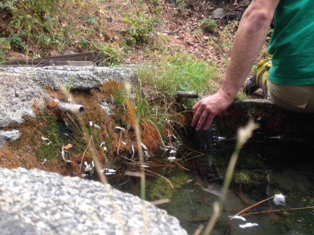
| Water Source Details: | Spring flowing strongly from one of two pipes |
| Weather Conditions: | |
| Images: | Pat Spring |
Pat Springs Camp Survey - 01-15-2018 - by Los Padres Forest Association| Link: | Pat Springs Camp |
| Date: | 01-15-2018 |
| Surveyor Name: | Los Padres Forest Association |
| Camp Description: | Cool writeup from Leor Pantilat who recently paid Pat Springs Camp a visit. Enjoy: |
| Water Source: | Flowing |
| Water Source Details: | "Always reliable Pat Spring." |
| Weather Conditions: |
Pat Springs Camp Survey - 10-24-2015 - by L.North| Link: | Pat Springs Camp |
| Date: | 10-24-2015 |
| Surveyor Name: | L.North |
| Camp Description: | The trail from Bottecher's Gap was a little crowded with brush, but nothing we couldn't push through even with packs. Pat Springs was the only water we saw or heard about from other hikers. The campsites were clear and quite nice with plenty of room. There were 4 or 5 other groups but we couldn't see or hear any of them from our campsite. There were LOTS of flies sunrise to sunset. They weren't the biting sort, but they were annoying. |
| Water Source: | Trickle |
| Water Source Details: | Water was steadily flowing into the basin. Top holding tank was full. |
| Weather Conditions: | 80 / 55 and clear. |
| Images: | Water source |
Pat Springs Camp Survey - 11-29-2013 - by Anonymous Surveyor| Link: | Pat Springs Camp |
| Date: | 11-29-2013 |
| Surveyor Name: | Anonymous Surveyor |
| Camp Description: | The real camping spot is a bit off the trail towards the ocean. You will see the place where people camped right before the cliff down. The views of the ocean are spectacular there. The park doesn't allow campfires but apparently some people didn't get the memo. Every time I come, there is a recent fire pit. One can also see Carmel from this campground and sometimes obtain cell signal. |
| Water Source: | Trickle |
| Water Source Details: | The water source is Pat Spring. Nice clean established spring with water buffer. |
| Weather Conditions: | Cold after sunset |
Pat Springs Camp Survey - 01-12-1968 - by Troop 97 BSA Monterey Ca.| Link: | Pat Springs Camp |
| Date: | 01-12-1968 |
| Surveyor Name: | Troop 97 BSA Monterey Ca. |
| Camp Description: | Back in 1968 thirty five boy scouts had to be air lifted by three army helicopters to Fort Ord Ca. The Troop 97 BSA with about 50 hikers left Botchers Gap saturday morning for Pat Springs Camp, a 10 mile trek. Sunday afternoon they left Pat Springs headed to Los Padres Dam, a 9 mile hike. They took the Ventana Trail by accident to Carmel River Campground instead of Blue Ridge Trail to the north. The trail was overgrown and simply disappeared on a ridgetop. The 10 lead scouts broke trail and slipped down to Rattlesnake Creek about 4pm sunday afternoon. They hopped rocks to Danish Creek, and hopped rocks to Carmel River. The scouts were trapped in the gorge of the Los Padres Dam, the water became too deep to wade across so they scaled the steep terrain in the dark with ropes. They came out in Jameburge about 3am with no food, water and flashlight batteries were dead. Monday afternoon the remainder of the hikers were spotted signaling by the air and they were flown out of the woods. This was in the Monterey Peninsula Herald spring 1968. If you are going to Los Padres Dam from Pat Springs, one must go back to Big Pines Camp and take the Blue Ridge Trail. |
| Water Source: | Flowing |
| Water Source Details: | fill your canteens at Pat Springs its the only water for 10 miles |
| Weather Conditions: |
 Survey / Report Form